Chest opened
+${chestReward.xp} XP
Explorer
NOUVEAU ×${chestReward.collectible.quantity}
tapez pour fermer
Chest locked

Open chests in the app

Around Us is built for your phone — chests unlock when you walk, explore and capture nearby places.

Enable Location

We need your location to show you interesting places around you

Discover nearby places

Find interesting locations and hidden gems around you

Precise directions

Get accurate directions and distances to places

Your location is never shared with other users. It's only used when you tap the location button.

Alaska North Slope

Log in to your account

Start exploring — it's free

Trusted by 72,980 travelers worldwide

Continue with Google
Continue with Apple
or

We will send you a code to connect

By continuing, you accept our Terms and Conditions and our Privacy Policy

Check your inbox

We've sent a pincode in your inbox. Please enter the code below.

Alaska North Slope
Discussion Reviews 1 Photos
44.6k Popularity

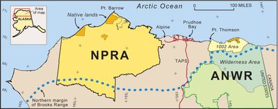
Alaska North Slope, Geographic region in northern Alaska, United States.

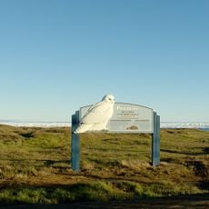
The Alaska North Slope is an expansive region at the far northern edge of the state, stretching between the Brooks Range and the Arctic Ocean. The landscape consists primarily of tundra terrain and mountain ranges beneath extreme climatic conditions.

Oil was discovered at Prudhoe Bay in 1968, leading to construction of the Trans-Alaska Pipeline System and fundamentally transforming the region's economy. This development brought industrial activity to an otherwise remote area and reshaped Alaska's future.

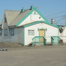
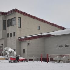
The Iñupiat people practice traditional hunting and fishing that sustains their communities and shapes how they relate to this land. These activities remain central to daily life and identity in settlements across the region.

Most locations are accessible only by small aircraft or seasonal ice roads that operate during winter, making overland travel limited and unpredictable. Visitors should prepare for extreme weather conditions and allow flexibility in their travel plans.

The region experiences 24-hour darkness in winter and constant daylight in summer, creating an unusual rhythm that affects wildlife patterns and human daily routines. This extreme light cycle shapes nearly every aspect of life throughout the year.

The community of curious travelers

AroundUs brings together thousands of curated places, local tips, and hidden gems, enriched daily by 60,000 contributors worldwide.

Start exploring
Location
GPS coordinates
69.05790,-152.86300
Latest update
March 5, 2026 18:15
Around this place
Arctic National Wildlife Refuge
United States of America

Arctic National Wildlife Refuge

376.3 km
Mount Isto
United States of America

Mount Isto

359.4 km
Rogers-Post Site
United States of America

Rogers-Post Site

282.1 km
Point Barrow Long Range Radar Site
United States of America

Point Barrow Long Range Radar Site

289.8 km
E. L. Patton Yukon River Bridge
United States of America

E. L. Patton Yukon River Bridge

378.9 km
Gates of the Arctic Wilderness
United States of America

Gates of the Arctic Wilderness

107 km
Mount Igikpak
United States of America

Mount Igikpak

202.6 km
Arrigetch Peaks
United States of America

Arrigetch Peaks

190.2 km
Point Barrow Refuge Station
United States of America

Point Barrow Refuge Station

289.6 km
Leffingwell Camp Site
United States of America

Leffingwell Camp Site

292.1 km
Noatak Wilderness
United States of America

Noatak Wilderness

293.6 km
Kanuti National Wildlife Refuge
United States of America

Kanuti National Wildlife Refuge

297.2 km
John River
United States of America

John River

182.2 km
Selawik National Wildlife Refuge
United States of America

Selawik National Wildlife Refuge

381.8 km
Birnirk Site
United States of America

Birnirk Site

287.8 km
North Fork Koyukuk River
United States of America

North Fork Koyukuk River

196.2 km
Selawik River
United States of America

Selawik River

367 km
Gallagher Flint Station Archeological Site
United States of America

Gallagher Flint Station Archeological Site

168 km
Onion Portage Archeological District
United States of America

Onion Portage Archeological District

313.9 km
Itkillik River
United States of America

Itkillik River

94.5 km
Squirrel River
United States of America

Squirrel River

394.3 km
Walker Lake
United States of America

Walker Lake

223.8 km
Iñupiat Heritage Center
United States of America

Iñupiat Heritage Center

289.3 km
Kanuti River
United States of America

Kanuti River

320.2 km
Peters Glacier (Brooks Range)
United States of America

Peters Glacier (Brooks Range)

313.8 km
Utqiaġvik Church Manse
United States of America

Utqiaġvik Church Manse

289.3 km
Salmon River
United States of America

Salmon River

332.2 km
Dall River
United States of America

Dall River

347.1 km
Show the full map
Reviews
Share your experience

No review yet

Discussions
Start a discussion...

No discussion yet

« Alaska North Slope - Geographic region in northern Alaska, United States » is provided by Around Us (aroundus.com). Images and texts are derived from Wikimedia project under a Creative Commons license. You are allowed to copy, distribute, and modify copies of this page, under the conditions set by the license, as long as this note is clearly visible.

Discover hidden gems everywhere you go!

From secret cafés to breathtaking viewpoints, skip the crowded tourist spots and find places that match your style. Our app makes it easy with voice search, smart filtering, route optimization, and insider tips from travelers worldwide. Download now for the complete mobile experience.

Around Us App Screenshot

A unique approach to discovering new places

Le Figaro

All the places worth exploring

France Info

A tailor-made excursion in just a few clicks

20 Minutes

Around Us
Travel Guide & Maps
Download

Send to your phone

QR Code
1

Open the camera app on your mobile.

2

Point at the QR code with your camera. A notification will appear.

3

Tap the notification to open the link.