Enable Location

We need your location to show you interesting places around you

Discover nearby places

Find interesting locations and hidden gems around you

Precise directions

Get accurate directions and distances to places

Your location is never shared with other users. It's only used when you tap the location button.

Deadhorse

Log in to your account

Start exploring — it's free

Trusted by 68,146 travelers worldwide

Continue with Google
Continue with Apple
or

We will send you a code to connect

By continuing, you accept our Terms and Conditions and our Privacy Policy

Check your inbox

We've sent a pincode in your inbox. Please enter the code below.

Discussion Reviews 1 Photos
69.6k Popularity

Deadhorse, Industrial community in North Slope Borough, Alaska, US

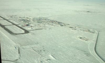
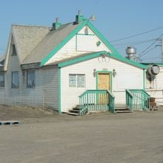
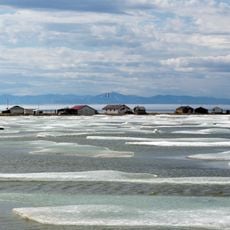
Deadhorse is an industrial settlement in North Slope Borough in northern Alaska near the Arctic Ocean. The buildings stand on gravel platforms scattered across the frozen tundra and consist mainly of barracks, warehouses and technical installations.

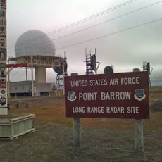
Deadhorse appeared in the late 1960s after large oil reserves were discovered at Prudhoe Bay. Infrastructure was quickly built to enable drilling and transport in the remote Arctic region.

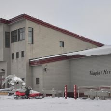
The name Deadhorse likely comes from an old pack animal found in the area before oil extraction began. Today simple dormitories and canteens shape the scenery, where workers rest after long shifts.

Most visitors arrive via the Dalton Highway, a long gravel road leading north from Fairbanks, or fly to the local airport. In summer the days remain bright, while in winter darkness and extreme cold make conditions harder.

The population swings between roughly 25 permanent residents and up to 3,000 people during work periods. Temperatures can drop to minus 40 degrees Fahrenheit (minus 40 Celsius) in winter, greatly limiting daily routines.

The community of curious travelers

AroundUs brings together thousands of curated places, local tips, and hidden gems, enriched daily by 60,000 contributors worldwide.

Start exploring
GPS coordinates
70.19995,-148.46182
Latest update
December 13, 2025 17:51
Around this place
Arctic National Wildlife Refuge
United States of America

Arctic National Wildlife Refuge

252 km
Ivvavik National Park
Canada

Ivvavik National Park

350.5 km
Vuntut National Park
Canada

Vuntut National Park

392.6 km
Mount Isto
United States of America

Mount Isto

211.4 km
Rogers-Post Site
United States of America

Rogers-Post Site

333.4 km
Point Barrow Long Range Radar Site
United States of America

Point Barrow Long Range Radar Site

324.7 km
E. L. Patton Yukon River Bridge
United States of America

E. L. Patton Yukon River Bridge

484.3 km
Gates of the Arctic Wilderness
United States of America

Gates of the Arctic Wilderness

296.4 km
Yukon Flats National Wildlife Refuge
United States of America

Yukon Flats National Wildlife Refuge

442.1 km
Mount Igikpak
United States of America

Mount Igikpak

405.5 km
Arrigetch Peaks
United States of America

Arrigetch Peaks

385.3 km
Point Barrow Refuge Station
United States of America

Point Barrow Refuge Station

328.3 km
Leffingwell Camp Site
United States of America

Leffingwell Camp Site

90.9 km
Noatak Wilderness
United States of America

Noatak Wilderness

498.9 km
Kanuti National Wildlife Refuge
United States of America

Kanuti National Wildlife Refuge

443.2 km
John River
United States of America

John River

338.6 km
Birnirk Site
United States of America

Birnirk Site

327 km
North Fork Koyukuk River
United States of America

North Fork Koyukuk River

319.6 km
Herschel Island-Qikiqtaruk Territorial Park
Canada

Herschel Island-Qikiqtaruk Territorial Park

366.6 km
Kendall Island Migratory Bird Sanctuary
Canada

Kendall Island Migratory Bird Sanctuary

522.7 km
Gallagher Flint Station Archeological Site
United States of America

Gallagher Flint Station Archeological Site

93.2 km
Onion Portage Archeological District
United States of America

Onion Portage Archeological District

526.4 km
Itkillik River
United States of America

Itkillik River

133 km
Walker Lake
United States of America

Walker Lake

416.9 km
Iñupiat Heritage Center
United States of America

Iñupiat Heritage Center

327.6 km
Kanuti River
United States of America

Kanuti River

460.3 km
Peters Glacier (Brooks Range)
United States of America

Peters Glacier (Brooks Range)

169.5 km
Utqiaġvik Church Manse
United States of America

Utqiaġvik Church Manse

328.4 km
Show the full map
Reviews
Share your experience

No review yet

Discussions
Start a discussion...

No discussion yet

« Deadhorse - Industrial community in North Slope Borough, Alaska, US » is provided by Around Us (aroundus.com). Images and texts are derived from Wikimedia project under a Creative Commons license. You are allowed to copy, distribute, and modify copies of this page, under the conditions set by the license, as long as this note is clearly visible.

Discover hidden gems everywhere you go!

From secret cafés to breathtaking viewpoints, skip the crowded tourist spots and find places that match your style. Our app makes it easy with voice search, smart filtering, route optimization, and insider tips from travelers worldwide. Download now for the complete mobile experience.

Around Us App Screenshot

A unique approach to discovering new places

Le Figaro

All the places worth exploring

France Info

A tailor-made excursion in just a few clicks

20 Minutes

Around Us
Travel Guide & Maps
Download

Send to your phone

QR Code
1

Open the camera app on your mobile.

2

Point at the QR code with your camera. A notification will appear.

3

Tap the notification to open the link.