Chest opened
+${chestReward.xp} XP
Explorer
NOUVEAU ×${chestReward.collectible.quantity}
tapez pour fermer
Chest locked

Open chests in the app

Around Us is built for your phone — chests unlock when you walk, explore and capture nearby places.

Enable Location

We need your location to show you interesting places around you

Discover nearby places

Find interesting locations and hidden gems around you

Precise directions

Get accurate directions and distances to places

Your location is never shared with other users. It's only used when you tap the location button.

Prudhoe Bay Oil Field

Log in to your account

Start exploring — it's free

Trusted by 72,880 travelers worldwide

Continue with Google
Continue with Apple
or

We will send you a code to connect

By continuing, you accept our Terms and Conditions and our Privacy Policy

Check your inbox

We've sent a pincode in your inbox. Please enter the code below.

Prudhoe Bay Oil Field
Discussion Reviews 2 Photos
59.4k Popularity

Prudhoe Bay Oil Field, Oil field in North Slope, Alaska, US.

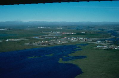
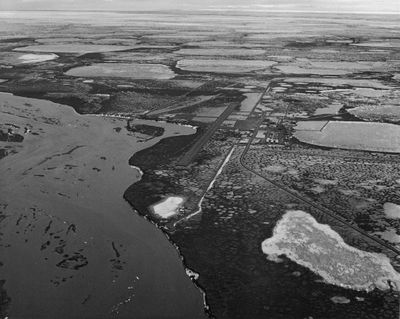
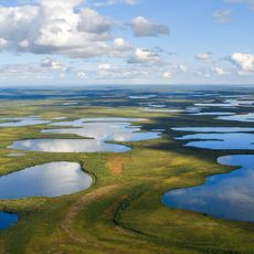
Prudhoe Bay Oil Field is an oil field on the Beaufort Sea coast in northern Alaska. The installations spread across a wide terrain with drilling rigs, processing facilities, and a network of pipelines running through the arctic landscape.

The first confirmation drilling took place in March 1968 after geologists surveyed the region for years. Commercial production began in June 1977 once the Trans-Alaska pipeline was completed and oil moved south for the first time.

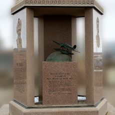
The Prudhoe Bay Oil Field Discovery Well Site earned recognition on the National Register of Historic Places for its role in Alaska's industrial development.

Access to the oil field is strictly controlled, and visitors need special permission to enter the site. The facilities operate year-round under extreme arctic conditions that become especially harsh in winter.

The discovery of the field triggered the construction of the longest pipeline in North America, spanning two mountain ranges and more than 800 rivers. The processed natural gas is not sold but pumped back underground to maintain pressure in the reservoirs.

The community of curious travelers

AroundUs brings together thousands of curated places, local tips, and hidden gems, enriched daily by 60,000 contributors worldwide.

Start exploring
Location
GPS coordinates
70.30670,-148.73200
Latest update
December 13, 2025 19:25
Around this place
Arctic National Wildlife Refuge
United States of America

Arctic National Wildlife Refuge

267.3 km
Kobuk Valley National Park
United States of America

Kobuk Valley National Park

520.9 km
Ivvavik National Park
Canada

Ivvavik National Park

362.4 km
Vuntut National Park
Canada

Vuntut National Park

407.2 km
Mount Isto
United States of America

Mount Isto

226.1 km
Rogers-Post Site
United States of America

Rogers-Post Site

319.5 km
Point Barrow Long Range Radar Site
United States of America

Point Barrow Long Range Radar Site

310.4 km
E. L. Patton Yukon River Bridge
United States of America

E. L. Patton Yukon River Bridge

495 km
Gates of the Arctic Wilderness
United States of America

Gates of the Arctic Wilderness

299.3 km
Yukon Flats National Wildlife Refuge
United States of America

Yukon Flats National Wildlife Refuge

456.2 km
Mount Igikpak
United States of America

Mount Igikpak

407.5 km
Arrigetch Peaks
United States of America

Arrigetch Peaks

388.4 km
Point Barrow Refuge Station
United States of America

Point Barrow Refuge Station

314 km
Leffingwell Camp Site
United States of America

Leffingwell Camp Site

101.7 km
Noatak Wilderness
United States of America

Noatak Wilderness

494.4 km
Kanuti National Wildlife Refuge
United States of America

Kanuti National Wildlife Refuge

451.2 km
John River
United States of America

John River

344.9 km
Birnirk Site
United States of America

Birnirk Site

312.8 km
North Fork Koyukuk River
United States of America

North Fork Koyukuk River

327.9 km
Herschel Island-Qikiqtaruk Territorial Park
Canada

Herschel Island-Qikiqtaruk Territorial Park

378.1 km
Gallagher Flint Station Archeological Site
United States of America

Gallagher Flint Station Archeological Site

104.7 km
Onion Portage Archeological District
United States of America

Onion Portage Archeological District

525.5 km
Itkillik River
United States of America

Itkillik River

137 km
Walker Lake
United States of America

Walker Lake

420.4 km
Iñupiat Heritage Center
United States of America

Iñupiat Heritage Center

313.4 km
Kanuti River
United States of America

Kanuti River

468.8 km
Peters Glacier (Brooks Range)
United States of America

Peters Glacier (Brooks Range)

184.7 km
Utqiaġvik Church Manse
United States of America

Utqiaġvik Church Manse

314.1 km
Show the full map
Reviews
Share your experience

No review yet

Discussions
Start a discussion...

No discussion yet

« Prudhoe Bay Oil Field - Oil field in North Slope, Alaska, US » is provided by Around Us (aroundus.com). Images and texts are derived from Wikimedia project under a Creative Commons license. You are allowed to copy, distribute, and modify copies of this page, under the conditions set by the license, as long as this note is clearly visible.

Discover hidden gems everywhere you go!

From secret cafés to breathtaking viewpoints, skip the crowded tourist spots and find places that match your style. Our app makes it easy with voice search, smart filtering, route optimization, and insider tips from travelers worldwide. Download now for the complete mobile experience.

Around Us App Screenshot

A unique approach to discovering new places

Le Figaro

All the places worth exploring

France Info

A tailor-made excursion in just a few clicks

20 Minutes

Around Us
Travel Guide & Maps
Download

Send to your phone

QR Code
1

Open the camera app on your mobile.

2

Point at the QR code with your camera. A notification will appear.

3

Tap the notification to open the link.