Chest opened
+${chestReward.xp} XP
Explorer
NOUVEAU ×${chestReward.collectible.quantity}
tapez pour fermer
Chest locked

Open chests in the app

Around Us is built for your phone — chests unlock when you walk, explore and capture nearby places.

Enable Location

We need your location to show you interesting places around you

Discover nearby places

Find interesting locations and hidden gems around you

Precise directions

Get accurate directions and distances to places

Your location is never shared with other users. It's only used when you tap the location button.

Deadhorse Airport

Log in to your account

Start exploring — it's free

Trusted by 72,985 travelers worldwide

Continue with Google
Continue with Apple
or

We will send you a code to connect

By continuing, you accept our Terms and Conditions and our Privacy Policy

Check your inbox

We've sent a pincode in your inbox. Please enter the code below.

Deadhorse Airport
Discussion Reviews 1 Photos
17.6k Popularity

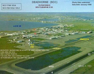
Deadhorse Airport, airport in Alaska

Deadhorse Airport is a small aerodrome on the North Slope in Alaska that primarily serves workers and visitors accessing the Prudhoe Bay oil field and surrounding region. The facility has basic counters and gates designed for practical operation rather than comfort, with minimal services beyond essentials.

The airport was established to support oil production in Prudhoe Bay, which began operating in the 1970s. It has served since then as the gateway for transporting personnel and supplies to this remote industrial region.

The airport is located in a region with harsh weather, so travelers should prepare for extreme cold and bring appropriate clothing for both the flight and time outside. Flights do not run on frequent schedules, so it is important to confirm connections ahead and allow for possible weather-related delays.

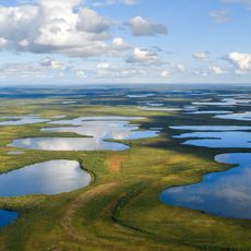
This airport is one of the few practical ways to reach this extremely remote region, as there are no continuous road connections to the area. Without this small facility, many people would have no economic way to access the jobs and resources in the North Slope.

The community of curious travelers

AroundUs brings together thousands of curated places, local tips, and hidden gems, enriched daily by 60,000 contributors worldwide.

Start exploring
Location
GPS coordinates
70.19516,-148.46482
Latest update
February 17, 2026 00:40
Around this place
Arctic National Wildlife Refuge
United States of America

Arctic National Wildlife Refuge

251.7 km
Ivvavik National Park
Canada

Ivvavik National Park

350.5 km
Vuntut National Park
Canada

Vuntut National Park

392.4 km
Mount Isto
United States of America

Mount Isto

211.2 km
Rogers-Post Site
United States of America

Rogers-Post Site

333.5 km
Point Barrow Long Range Radar Site
United States of America

Point Barrow Long Range Radar Site

324.8 km
E. L. Patton Yukon River Bridge
United States of America

E. L. Patton Yukon River Bridge

483.7 km
Gates of the Arctic Wilderness
United States of America

Gates of the Arctic Wilderness

295.9 km
Yukon Flats National Wildlife Refuge
United States of America

Yukon Flats National Wildlife Refuge

441.6 km
Mount Igikpak
United States of America

Mount Igikpak

405 km
Arrigetch Peaks
United States of America

Arrigetch Peaks

384.8 km
Point Barrow Refuge Station
United States of America

Point Barrow Refuge Station

328.4 km
Leffingwell Camp Site
United States of America

Leffingwell Camp Site

91 km
Noatak Wilderness
United States of America

Noatak Wilderness

498.5 km
Kanuti National Wildlife Refuge
United States of America

Kanuti National Wildlife Refuge

442.7 km
John River
United States of America

John River

338.1 km
Birnirk Site
United States of America

Birnirk Site

327.1 km
North Fork Koyukuk River
United States of America

North Fork Koyukuk River

319.1 km
Herschel Island-Qikiqtaruk Territorial Park
Canada

Herschel Island-Qikiqtaruk Territorial Park

366.6 km
Kendall Island Migratory Bird Sanctuary
Canada

Kendall Island Migratory Bird Sanctuary

522.8 km
Gallagher Flint Station Archeological Site
United States of America

Gallagher Flint Station Archeological Site

92.7 km
Onion Portage Archeological District
United States of America

Onion Portage Archeological District

526 km
Itkillik River
United States of America

Itkillik River

132.5 km
Walker Lake
United States of America

Walker Lake

416.5 km
Iñupiat Heritage Center
United States of America

Iñupiat Heritage Center

327.8 km
Kanuti River
United States of America

Kanuti River

459.7 km
Peters Glacier (Brooks Range)
United States of America

Peters Glacier (Brooks Range)

169.2 km
Utqiaġvik Church Manse
United States of America

Utqiaġvik Church Manse

328.5 km
Show the full map
Reviews
Share your experience

No review yet

Discussions
Start a discussion...

No discussion yet

« Deadhorse Airport - airport in Alaska » is provided by Around Us (aroundus.com). Images and texts are derived from Wikimedia project under a Creative Commons license. You are allowed to copy, distribute, and modify copies of this page, under the conditions set by the license, as long as this note is clearly visible.

Discover hidden gems everywhere you go!

From secret cafés to breathtaking viewpoints, skip the crowded tourist spots and find places that match your style. Our app makes it easy with voice search, smart filtering, route optimization, and insider tips from travelers worldwide. Download now for the complete mobile experience.

Around Us App Screenshot

A unique approach to discovering new places

Le Figaro

All the places worth exploring

France Info

A tailor-made excursion in just a few clicks

20 Minutes

Around Us
Travel Guide & Maps
Download

Send to your phone

QR Code
1

Open the camera app on your mobile.

2

Point at the QR code with your camera. A notification will appear.

3

Tap the notification to open the link.