Malpaís de Nealtican, Volcanic terrain in Tianguismanalco Municipality, Mexico
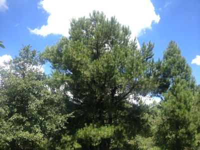
The Malpaís de Nealtican is an expansive volcanic rock formation with sharp lava outcrops that rise noticeably above the surrounding valley. The terrain spans a large area and creates a rough, uneven surface where a thick pine-oak forest grows.
This terrain formed about 2100 years ago from a major volcanic eruption that spread lava flows across the landscape. Since then, natural vegetation has taken root on the volcanic rock and shaped the land as it exists today.
The local communities use this space for traditional forest management and conservation efforts that keep the ecosystem protected. Visitors can observe how people care for the woodland and maintain the natural resources.
The site can be explored on foot using trails that lead to higher points and through different parts of the forest. It is best to wear sturdy footwear since the lava rocks are sharp and uneven.
The rocky ground and poor soil make this place unsuitable for farming, which means the original forest remains intact. These natural conditions have protected the area from conversion to farmland while surrounding regions are heavily cultivated.
Location: Tianguismanalco Municipality
GPS coordinates: 19.02425,-98.46228
Latest update: December 14, 2025 18:10
Popocatépetl
17 km
Great Pyramid of Cholula
17.3 km
Iztaccihuatl
25.7 km
Cholula
16.5 km
Zona arqueológica de Cholula
17.3 km
Estrella de Puebla
24.2 km
Puebla sinkhole
14.7 km
International Museum of the Baroque
22.7 km
Tonantzintla Observatory
15.5 km
San Francisco Acatepec church
16.2 km
Former convent of Saint Michael the Archangel
16.1 km
Iglesia de Nuestra Señora de los Remedios
17.3 km
San Gabriel Convent
17.1 km
La Constancia Mexicana
25.2 km
Torre Ejecutiva JV III
20.8 km
Santa María Tonantzintla
15 km
Former convent of Saint Andrew
8.4 km
Torre JV Juárez
25.5 km
Glaciar Norte
16.9 km
Monumento a los Héroes de la Independencia
26.4 km
Mercado de Sabores Poblanos
27.2 km
Our Lady of Guadalupe Sanctuary
27 km
Templo María Madre de la Iglesia, Huexotitla
26.6 kmTorre Ejecutiva JV II
20.7 km
Jardín Etnobotánico Francisco Peláez R.
16.3 km
Statue of Benito Juárez, Cholula
16.9 km
San Miguel Arcángel Fountain
16.9 km
Former convent of the Assumption of Our Lady
18.8 kmVisited this place? Tap the stars to rate it and share your experience / photos with the community! Try now! You can cancel it anytime.
Discover hidden gems everywhere you go!
From secret cafés to breathtaking viewpoints, skip the crowded tourist spots and find places that match your style. Our app makes it easy with voice search, smart filtering, route optimization, and insider tips from travelers worldwide. Download now for the complete mobile experience.
A unique approach to discovering new places❞
— Le Figaro
All the places worth exploring❞
— France Info
A tailor-made excursion in just a few clicks❞
— 20 Minutes