Chest opened
+${chestReward.xp} XP
Explorer
NOUVEAU ×${chestReward.collectible.quantity}
tapez pour fermer
Chest locked

Open chests in the app

Around Us is built for your phone — chests unlock when you walk, explore and capture nearby places.

Enable Location

We need your location to show you interesting places around you

Discover nearby places

Find interesting locations and hidden gems around you

Precise directions

Get accurate directions and distances to places

Your location is never shared with other users. It's only used when you tap the location button.

Upper Klamath Lake

Log in to your account

Start exploring — it's free

Trusted by 72,880 travelers worldwide

Continue with Google
Continue with Apple
or

We will send you a code to connect

By continuing, you accept our Terms and Conditions and our Privacy Policy

Check your inbox

We've sent a pincode in your inbox. Please enter the code below.

Upper Klamath Lake
Discussion Reviews 1 Photos
26k Popularity

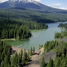
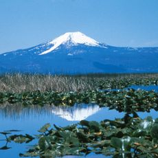
Upper Klamath Lake, Freshwater lake in Klamath County, Oregon.

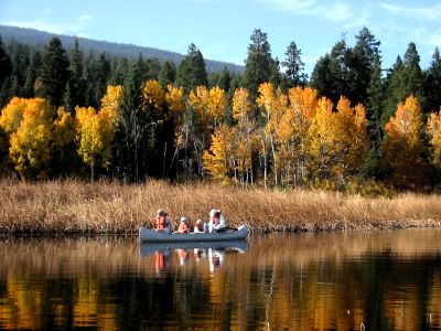
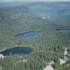
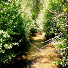
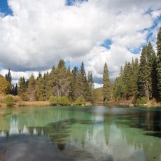
Upper Klamath Lake is a large freshwater body in a highland valley of Oregon with shorelines marked by reed beds and open meadows. The water spreads across considerable distances and offers wide, shallow areas with gently sloping banks throughout.

European fur traders from the Hudson's Bay Company reached the lake in 1826 and initially gave it a different name. This early exploration marked the start of outside contact with the water.

The lake holds deep meaning for the Klamath and Modoc peoples, who lived in this region for generations before outside settlement arrived. Their connection to the water and surrounding lands continues to shape how visitors understand the place today.

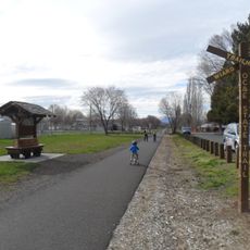
The lake has several boat launch points that appeal to anglers looking to fish for trout. Check which access points are available and plan your visit based on seasonal conditions before you go.

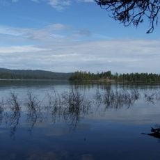
The water serves as a vital stopover for millions of migrating birds traveling between continents each year. Visitors can observe hundreds of bird species here, including white pelicans that seek refuge on the lake.

The community of curious travelers

AroundUs brings together thousands of curated places, local tips, and hidden gems, enriched daily by 60,000 contributors worldwide.

Start exploring
Location
Elevation above the sea
1,262 m
GPS coordinates
42.39222,-121.88028
Latest update
December 20, 2025 15:43
Around this place
Mount McLoughlin
United States of America

Mount McLoughlin

36.3 km
Train Mountain Railroad
United States of America

Train Mountain Railroad

20.1 km
Fort Klamath
United States of America

Fort Klamath

34.2 km
Fremont-Winema National Forest
United States of America

Fremont-Winema National Forest

44.8 km
Link River Dam
United States of America

Link River Dam

18.8 km
Sky Lakes Wilderness
United States of America

Sky Lakes Wilderness

38.3 km
OC&E Woods Line State Trail
United States of America

OC&E Woods Line State Trail

23.1 km
Collier Memorial State Park
United States of America

Collier Memorial State Park

27.9 km
Fish Lake
United States of America

Fish Lake

38.5 km
Sun Pass State Forest
United States of America

Sun Pass State Forest

38.4 km
John C. Boyle Dam
United States of America

John C. Boyle Dam

33 km
Jackson F. Kimball State Recreation Site
United States of America

Jackson F. Kimball State Recreation Site

39.4 km
Lake Ewauna
United States of America

Lake Ewauna

21.6 km
Mountain Lakes Wilderness
United States of America

Mountain Lakes Wilderness

18.7 km
Howard Prairie Lake
United States of America

Howard Prairie Lake

45.3 km
Bear Valley National Wildlife Refuge
United States of America

Bear Valley National Wildlife Refuge

38.1 km
Upper Klamath National Wildlife Refuge
United States of America

Upper Klamath National Wildlife Refuge

18.5 km
Fourmile Lake
United States of America

Fourmile Lake

31.8 km
Baldwin Hotel
United States of America

Baldwin Hotel

20.6 km
Willow Prairie Cabin
United States of America

Willow Prairie Cabin

42.2 km
Dead Indian Soda Springs
United States of America

Dead Indian Soda Springs

47.2 km
Lake of the Woods Ranger Station
United States of America

Lake of the Woods Ranger Station

28.5 km
Klamath Falls City Hall
United States of America

Klamath Falls City Hall

20.5 km
Blackburn Sanitarium
United States of America

Blackburn Sanitarium

19.8 km
Judge Henry L. Benson House
United States of America

Judge Henry L. Benson House

20.3 km
Honeymoon Creek Snow-Survey Cabin
United States of America

Honeymoon Creek Snow-Survey Cabin

40.2 km
Richardson–Ulrich House
United States of America

Richardson–Ulrich House

20.1 km
Klamath County Museum
United States of America

Klamath County Museum

20.2 km
Show the full map
Reviews
Share your experience

No review yet

Discussions
Start a discussion...

No discussion yet

« Upper Klamath Lake - Freshwater lake in Klamath County, Oregon » is provided by Around Us (aroundus.com). Images and texts are derived from Wikimedia project under a Creative Commons license. You are allowed to copy, distribute, and modify copies of this page, under the conditions set by the license, as long as this note is clearly visible.

Discover hidden gems everywhere you go!

From secret cafés to breathtaking viewpoints, skip the crowded tourist spots and find places that match your style. Our app makes it easy with voice search, smart filtering, route optimization, and insider tips from travelers worldwide. Download now for the complete mobile experience.

Around Us App Screenshot

A unique approach to discovering new places

Le Figaro

All the places worth exploring

France Info

A tailor-made excursion in just a few clicks

20 Minutes

Around Us
Travel Guide & Maps
Download

Send to your phone

QR Code
1

Open the camera app on your mobile.

2

Point at the QR code with your camera. A notification will appear.

3

Tap the notification to open the link.