Enable Location

We need your location to show you interesting places around you

Discover nearby places

Find interesting locations and hidden gems around you

Precise directions

Get accurate directions and distances to places

Your location is never shared with other users. It's only used when you tap the location button.

Bonneville Dam

Log in to your account

Start exploring — it's free

Trusted by 61,862 travelers worldwide

Continue with Google
Continue with Apple
or

We will send you a code to connect

By continuing, you accept our Terms and Conditions and our Privacy Policy

Check your inbox

We've sent a pincode in your inbox. Please enter the code below.

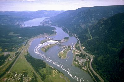
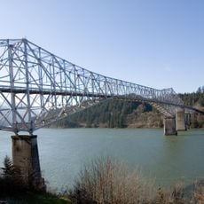
Bonneville Dam, Hydroelectric gravity dam on Columbia River, United States

Description

The Bonneville Dam stretches more than a kilometer between Oregon and Washington, using the drop of the Columbia River to generate power. The facility includes two powerhouses positioned at different points, along with a lock system for vessel traffic.

History

Construction began during the economic downturn as a work project and was completed within a few years. The facility was among the earliest large structures on the Columbia and transformed navigation upstream.

Culture

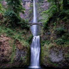
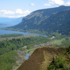
Fishing has been part of daily life along the Columbia River for centuries, and trails near the structure still recall that tradition. The visitor center shows how moving water produces power and what that means for the region.

Practical

The facility is accessible from both riverbanks, with parking available on the Oregon side. Visitors should allow enough time to see both the technical installations and the observation windows.

Did you know?

Underwater windows show salmon, trout, and other fish climbing through specially built ladders. These passages allow the animals to bypass the barrier and continue their migration routes.

Location
Location
Architects
Claussen and Claussen
Length
1,056 m
GPS coordinates
45.64417,-121.94083
Latest update
December 14, 2025 18:54

AroundUs brings together thousands of curated places, local tips, and hidden gems, enriched daily by 60,000 contributors worldwide. Discover all places nearby (Multnomah County).

Around this place
Multnomah Falls
United States of America

Multnomah Falls

15.6 km
Columbia River Gorge
United States of America

Columbia River Gorge

13.4 km
Bridge of the Gods
United States of America

Bridge of the Gods

3.7 km
United States of America

Bridge of the Gods

2.5 km
Beacon Rock State Park
United States of America

Beacon Rock State Park

6.2 km
Oneonta Gorge
United States of America

Oneonta Gorge

12.1 km
Punch Bowl Falls
United States of America

Punch Bowl Falls

4.4 km
Wahclella Falls
United States of America

Wahclella Falls

3 km
Horsetail Falls
United States of America

Horsetail Falls

11.6 km
Wahkeena Falls
United States of America

Wahkeena Falls

16.5 km
Cascade Locks and Canal
United States of America

Cascade Locks and Canal

4.4 km
Ainsworth State Park
United States of America

Ainsworth State Park

10.7 km
Table Mountain
United States of America

Table Mountain

6.3 km
Metlako Falls
United States of America

Metlako Falls

4 km
Franz Lake National Wildlife Refuge
United States of America

Franz Lake National Wildlife Refuge

11.5 km
Sheridan State Scenic Corridor
United States of America

Sheridan State Scenic Corridor

2.7 km
Greenleaf Peak
United States of America

Greenleaf Peak

8 km
Benson State Recreation Area
United States of America

Benson State Recreation Area

16.1 km
John B. Yeon State Scenic Corridor
United States of America

John B. Yeon State Scenic Corridor

4.5 km
Lake Bonneville
United States of America

Lake Bonneville

12.2 km
Twister Falls
United States of America

Twister Falls

9.8 km
Fort Raines
United States of America

Fort Raines

2 km
Cascade Locks Work Center
United States of America

Cascade Locks Work Center

8.7 km
Columbia Gorge Interpretive Center Museum
United States of America

Columbia Gorge Interpretive Center Museum

5.6 km
Beacon Rock
United States of America

Beacon Rock

6.5 km
Home Valley Beach
United States of America

Home Valley Beach

14.5 km
Bonneville Dam Historic District
United States of America

Bonneville Dam Historic District

427 m
Multnomah Falls Lodge and Footpath
United States of America

Multnomah Falls Lodge and Footpath

15.6 km
Show the full map
« Bonneville Dam - Hydroelectric gravity dam on Columbia River, United States » is provided by Around Us (aroundus.com). Images and texts are derived from Wikimedia project under a Creative Commons license. You are allowed to copy, distribute, and modify copies of this page, under the conditions set by the license, as long as this note is clearly visible.

Discover hidden gems everywhere you go!

From secret cafés to breathtaking viewpoints, skip the crowded tourist spots and find places that match your style. Our app makes it easy with voice search, smart filtering, route optimization, and insider tips from travelers worldwide. Download now for the complete mobile experience.

Around Us App Screenshot

A unique approach to discovering new places

Le Figaro

All the places worth exploring

France Info

A tailor-made excursion in just a few clicks

20 Minutes

Around Us
Travel Guide & Maps
Download

Send to your phone

QR Code
1

Open the camera app on your mobile.

2

Point at the QR code with your camera. A notification will appear.

3

Tap the notification to open the link.