Enable Location

We need your location to show you interesting places around you

Discover nearby places

Find interesting locations and hidden gems around you

Precise directions

Get accurate directions and distances to places

Your location is never shared with other users. It's only used when you tap the location button.

Alvord Desert

Log in to your account

Start exploring — it's free

Trusted by 61,554 travelers worldwide

Continue with Google
Continue with Apple
or

We will send you a code to connect

By continuing, you accept our Terms and Conditions and our Privacy Policy

Check your inbox

We've sent a pincode in your inbox. Please enter the code below.

Alvord Desert

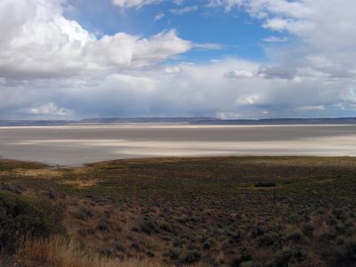
Alvord Desert, Dry lake and desert in Harney County, United States.

Description

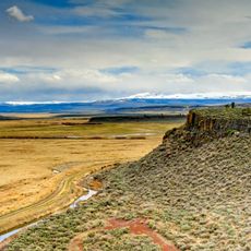
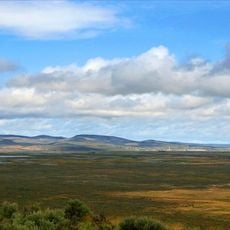
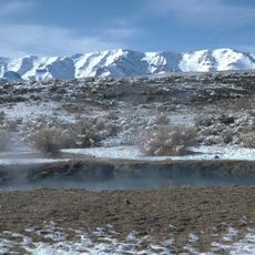
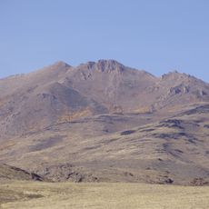
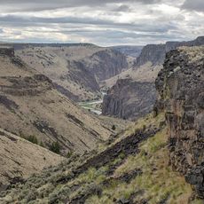
The Alvord Desert is a vast, flat basin of dried lakebed in southeastern Oregon's high desert region. The bare, light-colored surface is rimmed by mountains and offers minimal features beyond the hard, compact ground.

History

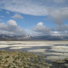
The basin dried out following the end of the last ice age, leaving behind a salty clay surface. The name honors General Benjamin Alvord, an army officer who served in the region during the Civil War.

Culture

The flat surface draws drivers seeking to break speed records, drawing those pursuing high-speed challenges. This location has become known to anyone interested in automotive record attempts.

Practical

The best time to visit is between July and November when the surface is dry enough for vehicles. Visitors should bring plenty of water, have reliable navigation, and understand the area is very remote.

Did you know?

The location sits between two mountain ranges, creating a rain shadow that keeps the area extremely dry. With minimal annual rainfall, this is one of Oregon's driest spots.

Location
Elevation above the sea
1,200 m
GPS coordinates
42.53545,-118.45601
Latest update
December 17, 2025 08:22

AroundUs brings together thousands of curated places, local tips, and hidden gems, enriched daily by 60,000 contributors worldwide. Discover all places nearby (Harney County).

Natural and historical sites across Oregon

Oregon offers a notable diversity of geological formations and natural landscapes ranging from the Pacific coastline to the volcanic plateaus of the eastern portion of the state. The Cascade Range dominates western Oregon with dense forests, waterfalls, and thermal springs, while the dry east...

Around this place
Malheur National Wildlife Refuge
United States of America

Malheur National Wildlife Refuge

87.2 km
Harney Basin
United States of America

Harney Basin

82.7 km
Sheldon National Wildlife Refuge
United States of America

Sheldon National Wildlife Refuge

105.1 km
Hart Mountain National Antelope Refuge
United States of America

Hart Mountain National Antelope Refuge

98.4 km
Steens Mountain Wilderness
United States of America

Steens Mountain Wilderness

28.2 km
Pete French Round Barn
United States of America

Pete French Round Barn

68.2 km
Northern Basin and Range ecoregion
United States of America

Northern Basin and Range ecoregion

129.7 km
Mickey Hot Springs
United States of America

Mickey Hot Springs

18.1 km
Fort McDermit
United States of America

Fort McDermit

93 km
David L. Shirk Ranch
United States of America

David L. Shirk Ranch

93.5 km
Sod House Ranch
United States of America

Sod House Ranch

87 km
Frenchglen Hotel State Heritage Site
United States of America

Frenchglen Hotel State Heritage Site

49.7 km
Greaser Petroglyph Site
United States of America

Greaser Petroglyph Site

117.9 km
P Ranch
United States of America

P Ranch

48 km
Camp Warner
United States of America

Camp Warner

105.2 km
United States of America

North Black Rock Range Wilderness

131.4 km
Riddle Ranch
United States of America

Riddle Ranch

60.9 km
Stone Bridge and the Oregon Central Military Wagon Road
United States of America

Stone Bridge and the Oregon Central Military Wagon Road

115.4 km
Granite Peak
United States of America

Granite Peak

120.2 km
United States of America

Old Camp Casino

127.8 km
Double-O Ranch Historic District
United States of America

Double-O Ranch Historic District

108 km
United States of America

North Jackson Mountains Wilderness

130.7 km
Deep Creek Falls
United States of America

Deep Creek Falls

129.3 km
Sheep Ranch Fortified House
United States of America

Sheep Ranch Fortified House

85.8 km
Desert Theatre
United States of America

Desert Theatre

126.7 km
Owyhee Canyon
United States of America

Owyhee Canyon

100.6 km
BLM Field Camp
United States of America

BLM Field Camp

78.7 km
BLM Field Camp
United States of America

BLM Field Camp

75.4 km
Show the full map
« Alvord Desert - Dry lake and desert in Harney County, United States » is provided by Around Us (aroundus.com). Images and texts are derived from Wikimedia project under a Creative Commons license. You are allowed to copy, distribute, and modify copies of this page, under the conditions set by the license, as long as this note is clearly visible.

Discover hidden gems everywhere you go!

From secret cafés to breathtaking viewpoints, skip the crowded tourist spots and find places that match your style. Our app makes it easy with voice search, smart filtering, route optimization, and insider tips from travelers worldwide. Download now for the complete mobile experience.

Around Us App Screenshot

A unique approach to discovering new places

Le Figaro

All the places worth exploring

France Info

A tailor-made excursion in just a few clicks

20 Minutes

Around Us
Travel Guide & Maps
Download

Send to your phone

QR Code
1

Open the camera app on your mobile.

2

Point at the QR code with your camera. A notification will appear.

3

Tap the notification to open the link.