Enable Location

We need your location to show you interesting places around you

Discover nearby places

Find interesting locations and hidden gems around you

Precise directions

Get accurate directions and distances to places

Your location is never shared with other users. It's only used when you tap the location button.

Pete French Round Barn

Log in to your account

Start exploring — it's free

Trusted by 62,369 travelers worldwide

Continue with Google
Continue with Apple
or

We will send you a code to connect

By continuing, you accept our Terms and Conditions and our Privacy Policy

Check your inbox

We've sent a pincode in your inbox. Please enter the code below.

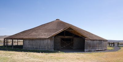
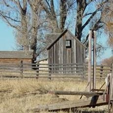
Pete French Round Barn, Heritage site in Harney County, United States.

The Pete French Round Barn is a circular building with a diameter of 100 feet, supported by 29 peeled juniper poles and topped with a cone-shaped roof above a stone perimeter wall. Inside, a circular stone wall encloses a central stable area, with an outer covered track running around it for horse exercise.

The barn was built in the 1880s by Peter French to train horses for his large cattle operation. It became part of one of the biggest ranches in the western region during that era.

The barn shows how American building ideas met Mexican vaquero traditions in the design of the interior space. Visitors can observe how these different practices came together to solve the problem of training horses year-round.

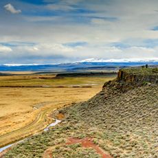
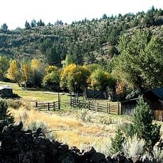
The site is located roughly 50 miles southeast of Burns and can be reached by car. Oregon Parks and Recreation Department maintains the property and welcomes visitors to explore the historic structure.

The circular design was an uncommon solution for the time, allowing horses to be trained in a covered space regardless of weather conditions. This type of layout was rare for large ranches in that era.

The community of curious travelers

AroundUs brings together thousands of curated places, local tips, and hidden gems, enriched daily by 60,000 contributors worldwide.

Start exploring
Location
GPS coordinates
43.13258,-118.64256
Latest update
December 11, 2025 11:07
Around this place
Malheur National Wildlife Refuge
United States of America

Malheur National Wildlife Refuge

22.1 km
Harney Basin
United States of America

Harney Basin

14.7 km
Owyhee Reservoir
United States of America

Owyhee Reservoir

111.8 km
Hart Mountain National Antelope Refuge
United States of America

Hart Mountain National Antelope Refuge

105.2 km
Steens Mountain Wilderness
United States of America

Steens Mountain Wilderness

52.6 km
Strawberry Mountain Wilderness
United States of America

Strawberry Mountain Wilderness

130.8 km
Northern Basin and Range ecoregion
United States of America

Northern Basin and Range ecoregion

134.4 km
Mickey Hot Springs
United States of America

Mickey Hot Springs

56.2 km
Lake Owyhee State Park
United States of America

Lake Owyhee State Park

126 km
David L. Shirk Ranch
United States of America

David L. Shirk Ranch

122.7 km
Sod House Ranch
United States of America

Sod House Ranch

23.1 km
Frenchglen Hotel State Heritage Site
United States of America

Frenchglen Hotel State Heritage Site

40.6 km
P Ranch
United States of America

P Ranch

39.4 km
Camp Warner
United States of America

Camp Warner

118.3 km
Monument Rock Wilderness
United States of America

Monument Rock Wilderness

133.9 km
Succor Creek State Natural Area
United States of America

Succor Creek State Natural Area

127.7 km
Riddle Ranch
United States of America

Riddle Ranch

8.3 km
Stone Bridge and the Oregon Central Military Wagon Road
United States of America

Stone Bridge and the Oregon Central Military Wagon Road

130.6 km
United States of America

Old Camp Casino

62.2 km
Double-O Ranch Historic District
United States of America

Double-O Ranch Historic District

56.5 km
Chickahominy Reservoir
United States of America

Chickahominy Reservoir

91 km
Moses and Mary Hart Stone House and Ranch Complex
United States of America

Moses and Mary Hart Stone House and Ranch Complex

120.2 km
Allison Ranger Station
United States of America

Allison Ranger Station

116.3 km
Sheep Ranch Fortified House
United States of America

Sheep Ranch Fortified House

92.3 km
Desert Theatre
United States of America

Desert Theatre

60.5 km
Owyhee Canyon
United States of America

Owyhee Canyon

82.9 km
BLM Field Camp
United States of America

BLM Field Camp

120 km
BLM Field Camp
United States of America

BLM Field Camp

98.2 km
Show the full map
« Pete French Round Barn - Heritage site in Harney County, United States » is provided by Around Us (aroundus.com). Images and texts are derived from Wikimedia project under a Creative Commons license. You are allowed to copy, distribute, and modify copies of this page, under the conditions set by the license, as long as this note is clearly visible.

Discover hidden gems everywhere you go!

From secret cafés to breathtaking viewpoints, skip the crowded tourist spots and find places that match your style. Our app makes it easy with voice search, smart filtering, route optimization, and insider tips from travelers worldwide. Download now for the complete mobile experience.

Around Us App Screenshot

A unique approach to discovering new places

Le Figaro

All the places worth exploring

France Info

A tailor-made excursion in just a few clicks

20 Minutes

Around Us
Travel Guide & Maps
Download

Send to your phone

QR Code
1

Open the camera app on your mobile.

2

Point at the QR code with your camera. A notification will appear.

3

Tap the notification to open the link.