See the monuments around you in AROpen chests in the app
Around Us is built for your phone — point your camera at the streets and discover the monuments and places around you in augmented reality.Around Us is built for your phone — chests unlock when you walk, explore and capture nearby places.
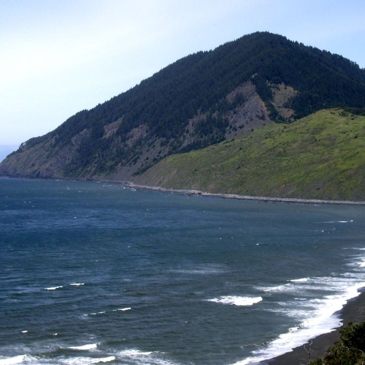
Oregon offers a notable diversity of geological formations and natural landscapes ranging from the Pacific coastline to the volcanic plateaus of the eastern portion of the state. The Cascade Range dominates western Oregon with dense forests, waterfalls, and thermal springs, while the dry east features desert areas, deep canyons, and extinct volcanic cones. The rugged coastline extends for 363 miles (584 km) and displays rock arches, historic lighthouses, and protected coastal sections. The region's geological history includes volcanic activity, lava flows, and rock layers dating back millions of years.
The collection includes natural hot springs such as Bagby Hot Springs, waterfalls like Abiqua Falls and Toketee Falls, and volcanic areas including Newberry National Volcanic Monument and Fort Rock. Coastal sites range from Cape Meares Lighthouse to Samuel H. Boardman State Scenic Corridor, while the interior presents locations such as the Painted Hills, the Alvord Desert, and the Owyhee Canyonlands. Lost Lake provides views of Mount Hood, Waldo Lake is known for its clarity, and Wizard Island rises from Crater Lake. The Steens Mountain Wilderness reaches elevations exceeding 9,000 feet (2,743 m), and Hells Canyon forms one of the deepest gorges in North America. These sites represent the geological processes and natural systems that have shaped Oregon across geological time.
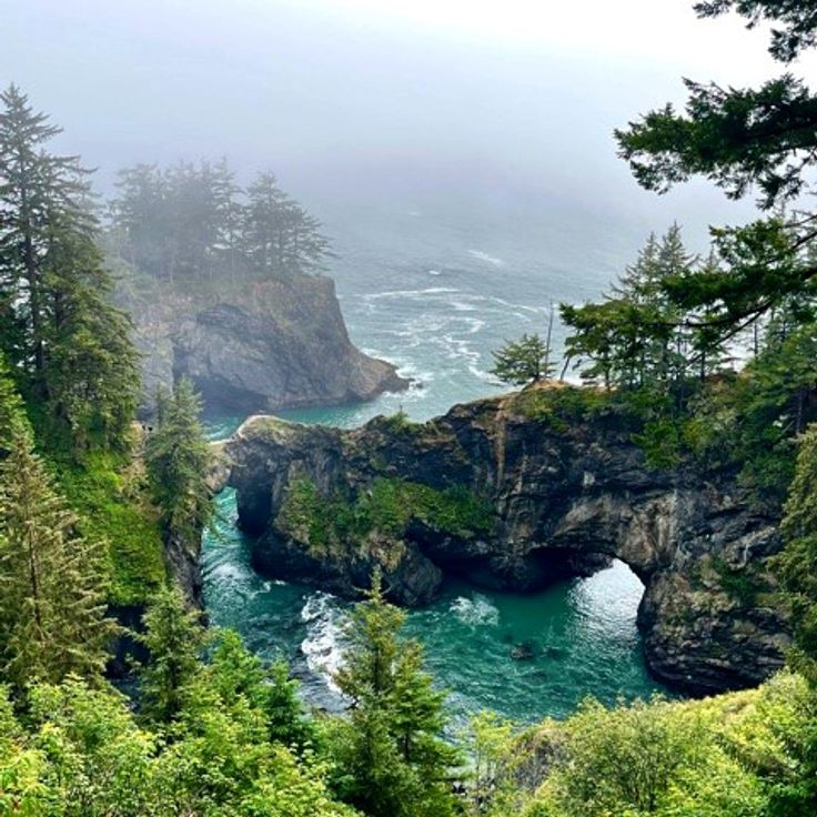
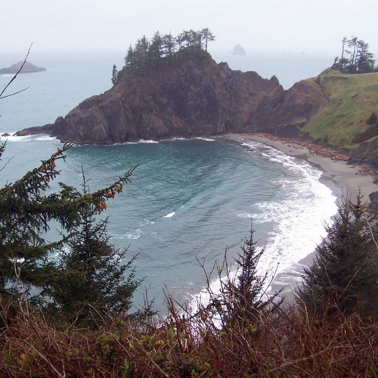
This rocky cove along southern Oregon's coastline contains three natural stone arches that span across the water, through which the Pacific flows. The formations resulted from erosion over thousands of years and provide habitat for sea turtles, seals, and various fish species. At low tide, visitors can explore tide pools and observe smaller marine life in the rock depressions, while the arches frame views of the open ocean.
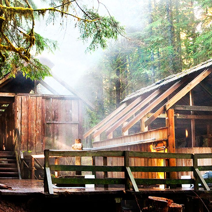
These geothermal springs in the Cascade Mountains reach temperatures up to 136°F (58°C) and sit within an old-growth forest in Oregon's natural landscape. Wooden bathhouses made from cedar provide visitors with space for soaking in the warm mineral waters.
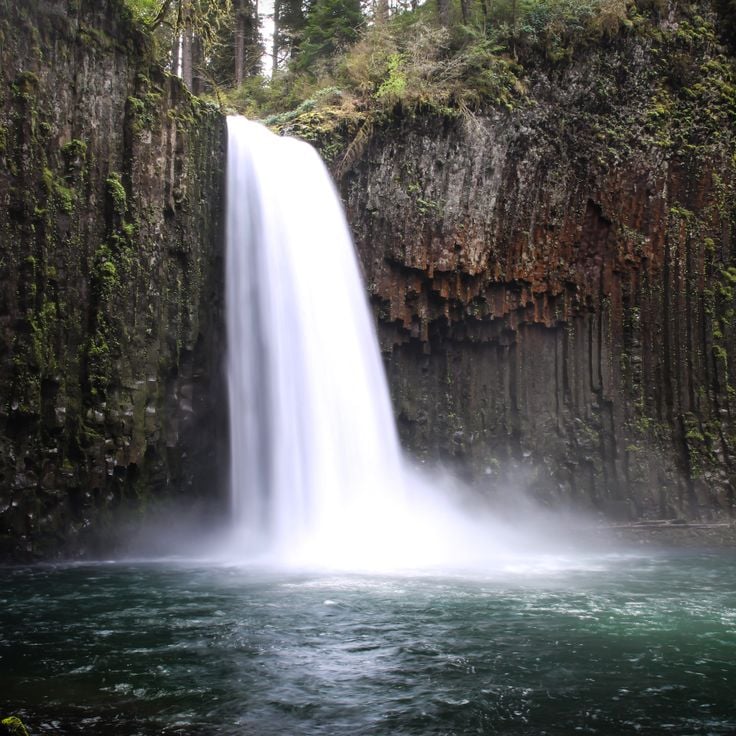
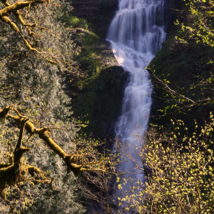
This 92-foot (28-meter) waterfall flows over basalt columns and ranks among Oregon's geological formations. Access to Abiqua Falls requires hiking through steep terrain with slippery sections, particularly challenging during winter and spring when water flow peaks.
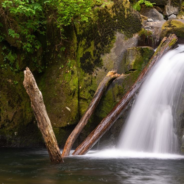
This waterfall formed in 1938 when engineers blasted a tunnel through rock to build the Columbia River Highway. Water drops roughly 100 feet (30 meters) to the ground below, creating an unusual feature along the historic road route. Hole-in-the-Wall Falls demonstrates how road construction projects occasionally produce new natural attractions. The waterfall sits within the forested slopes of the Columbia River Gorge area.
This natural basin along the McKenzie River fills with turquoise water from underground springs. The Blue Pool sits roughly 3 miles (5 km) upstream from Carmen Reservoir in an area where the river runs beneath a prehistoric lava field before reemerging at the surface. The water remains at approximately 37 degrees Fahrenheit (3 degrees Celsius) year-round, and swimming is prohibited here. Hikers reach the basin via the McKenzie River Trail through Douglas fir and cedar forest.
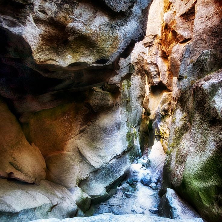
This narrow canyon in the Columbia River Gorge leads through moss covered rock walls to a 100 foot (30 meter) waterfall. Oneonta Gorge cuts through a basalt geological section and requires wading through water. The gorge is part of the geological formations that characterize Oregon. Access follows through a stream, and visitors must climb over driftwood to reach the waterfall. The rock walls rise up to 100 feet (30 meters) and create a damp microclimate with ferns and moss.
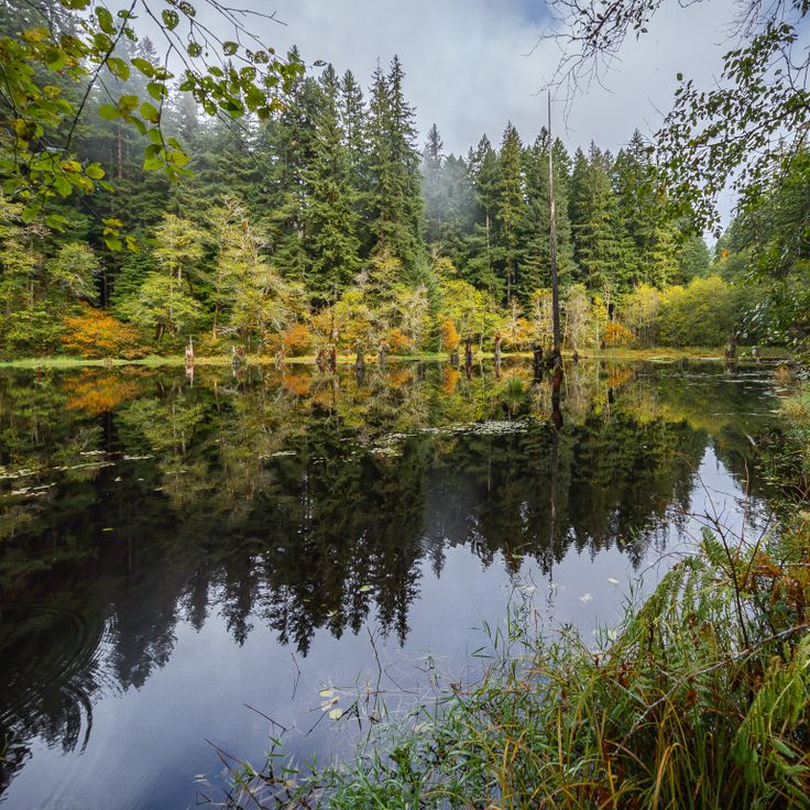
This alpine lake in the Mount Hood National Forest features a natural drain hole that depletes water levels during spring months. Lost Lake sits at roughly 3,200 feet (975 meters) elevation and offers views of Mount Hood. The drain hole, a lava tube of volcanic origin, typically empties the lake between May and July as snowmelt and precipitation decrease. The lake refills during fall and winter through rainfall and snow. Surrounding terrain includes hiking trails through conifer forests and lakeside camping areas.
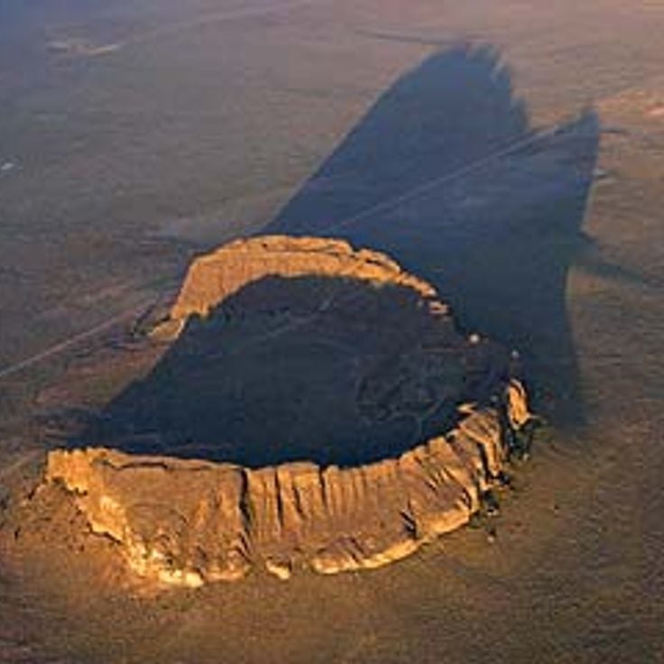
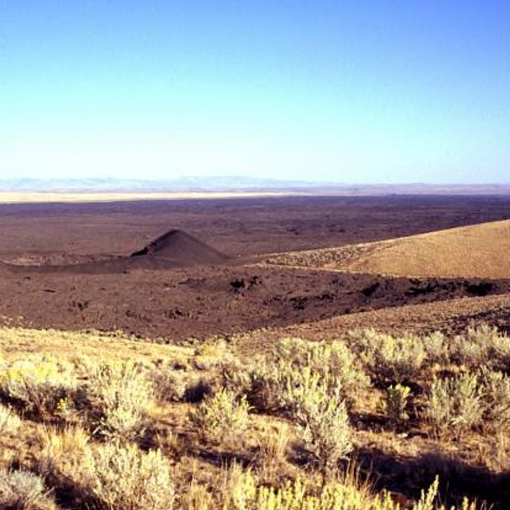
This natural area encompasses a circular volcanic crater rising 200 feet (60 meters) above the desert landscape and contains archaeological sites. Fort Rock State Natural Area represents one of Oregon's geological formations, documenting volcanic activity and early human settlement in the region. The crater formed through explosive interaction between lava and water.
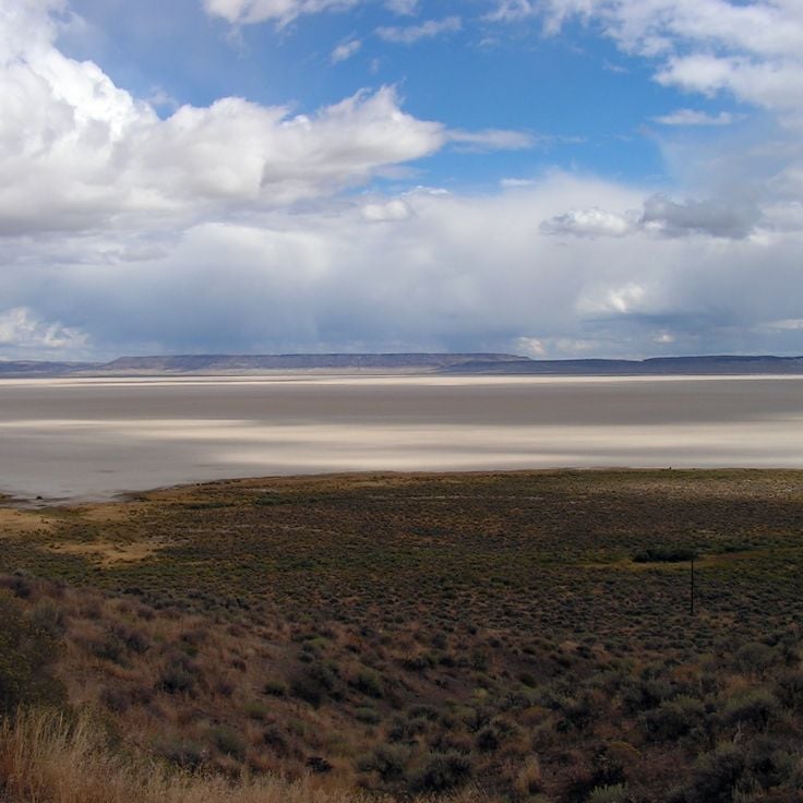
The Alvord Desert covers 84 square miles (217 square kilometers) with surface temperatures reaching 104°F (40°C) during summer months. This salt flat in southeastern Oregon contrasts with the volcanic landscapes and waterfalls found elsewhere across the state. The flat expanse formed from the evaporation of a prehistoric lake and displays characteristic salt deposits across the desert floor.
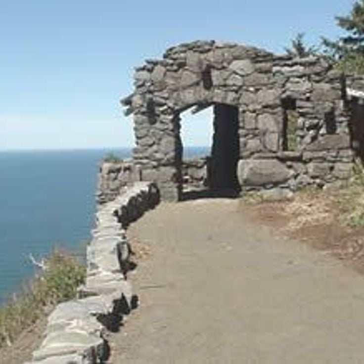
This cape sits on the Lincoln County coastline and rises 800 feet above sea level. Cape Perpetua ranks among the highest coastal points in Oregon and provides access to tide pools among the rocks and several trails along the cliffs. The landscape shows typical features of the region's volcanic geology with basalt formations and coastal vegetation. From the summit, visitors overlook the Pacific Ocean and the surrounding forest areas of Siuslaw National Forest.
This trail extends roughly 2.5 miles (4 kilometers) through a coastal forest and passes several cascades. Metal walkways and viewing platforms provide access to multiple waterfalls that flow through the rugged terrain of Lane County, offering insights into Oregon's geological formations and natural water features.
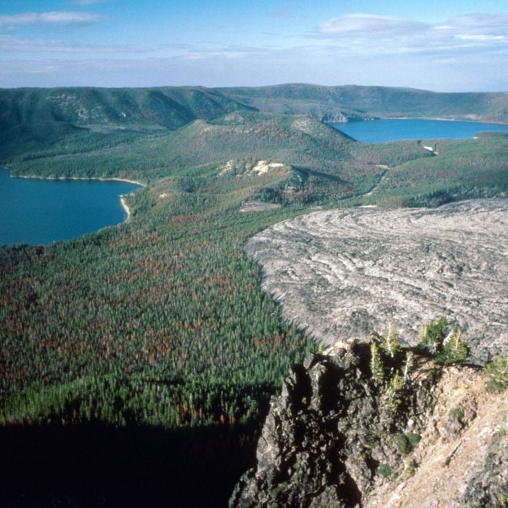
The Newberry National Volcanic Monument covers more than 80 square miles (210 square kilometers) of the Cascade volcanic chain in central Oregon, encompassing geological formations that illustrate the region's volcanic history. This protected area contains Paulina Peak, two crater lakes, extensive obsidian fields and the Big Obsidian Flow, a lava formation roughly 500 feet (150 meters) deep. Visitors can explore lava tubes, walk trails through various volcanic landscapes and observe the geological processes that shaped this environment over thousands of years.
Crack in the Ground is a volcanic fissure in Lake County, Oregon, extending approximately 2 miles (3.2 kilometers) and reaching depths of 70 feet (21 meters). This geological formation resulted from cooling lava flows roughly 1,000 years ago, when contracting basalt rock fractured and created an elongated chasm across the desert landscape. The fissure demonstrates volcanic activity in the region and displays textured basalt walls along its length. Visitors can walk along the floor of the fissure, where temperatures remain cooler than the surrounding terrain even during summer months. This site represents one of Oregon's less frequented geological features and illustrates the state's volcanic history.
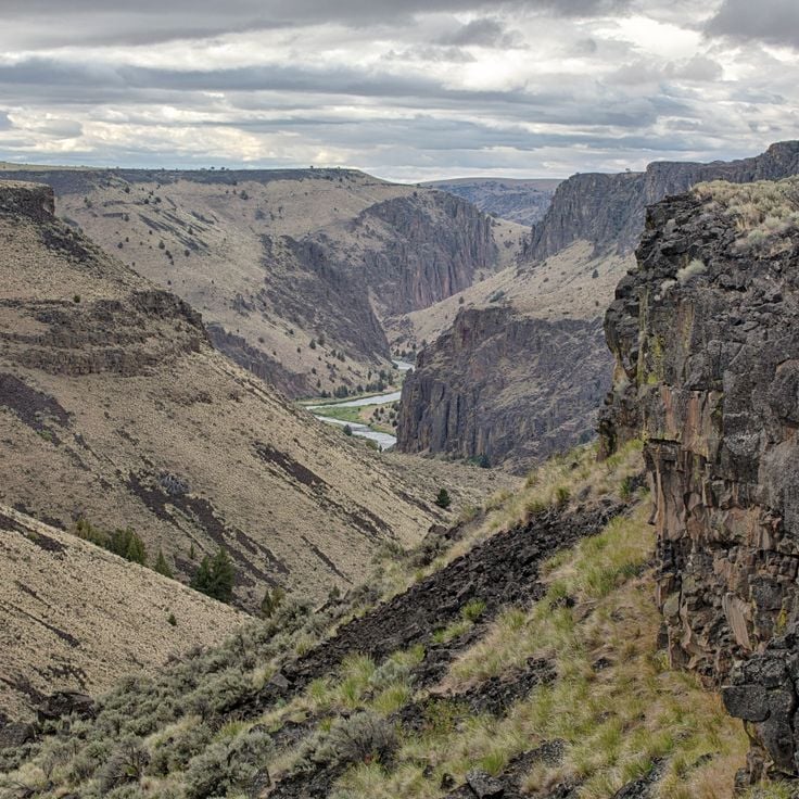
This region extends across 5,000 square miles (13,000 square kilometers) in remote sections of eastern Oregon with basalt cliffs rising up to 1,000 feet (300 meters) above canyon floors. The Owyhee Canyonlands contain multiple rivers and tributaries that have cut through volcanic rock to form canyon systems. The area consists of high desert plateaus, grasslands and arid sections with sparse vegetation. Hiking trails lead to viewpoints over the canyons and along river courses, while the geology displays volcanic activity dating back several million years.
This national monument sits at the convergence of three mountain ranges and hosts over 3500 plant and animal species across varied geological formations. The Cascade Siskiyou region demonstrates Oregon's natural diversity with connections between the Cascade Range, Siskiyou region, and Great Basin. The protected area covers approximately 114,000 acres (461 square kilometers) and presents ecosystems ranging from wetlands to alpine zones, accessible through hiking trails.
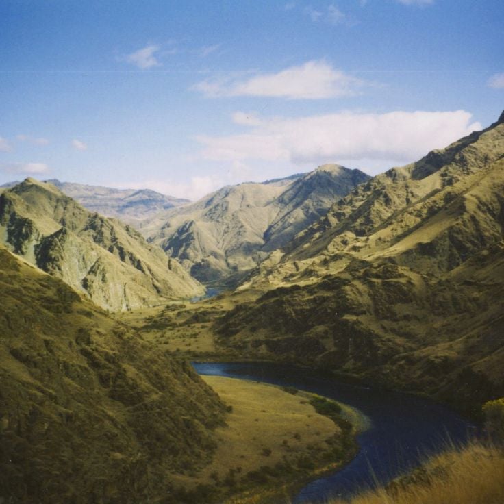
This canyon reaches 8000 feet (2440 meters) deep and marks the steep convergence of Oregon, Idaho and the Snake River. The Hells Canyon National Recreation Area preserves remnants of prehistoric Nez Perce settlements within the rock walls and along the plateaus, where archaeological sites document tools, petroglyphs and structural foundations. Trails traverse multiple climate zones from river level to alpine ridges. The Snake River section provides rafting through rapids between Idaho and Oregon, while higher elevations grant views across the Seven Devils Mountains and the Wallowa Range.
This 560-foot (170-meter) volcanic rock tower from the Cretaceous period rises above the Jackson County landscape and represents one of the geological features in southern Oregon. Pilot Rock formed roughly 80 million years ago through volcanic activity and now serves as a hiking destination with views of the Cascade Range. The ascent requires climbing experience for the upper sections.
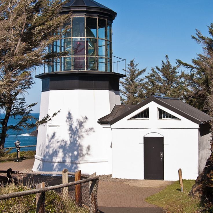
Cape Meares Lighthouse is one of Oregon's historic lighthouses, built in 1890 on a 200-foot (61-meter) cliff. The structure still houses its original first-order Fresnel lens and provides access to the state's coastal landscape.
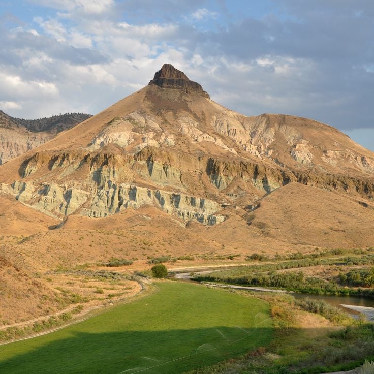
This unit of John Day Fossil Beds National Monument presents hills with red, black and gold mineral layering that documents 35 million years of geological development. The exposed formations belong to a broader collection of natural and historical sites across Oregon that includes volcanic landscapes and geological features. Visitors follow marked trails through the colored sedimentary deposits.
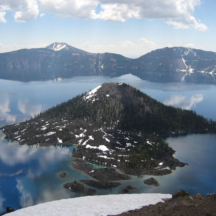
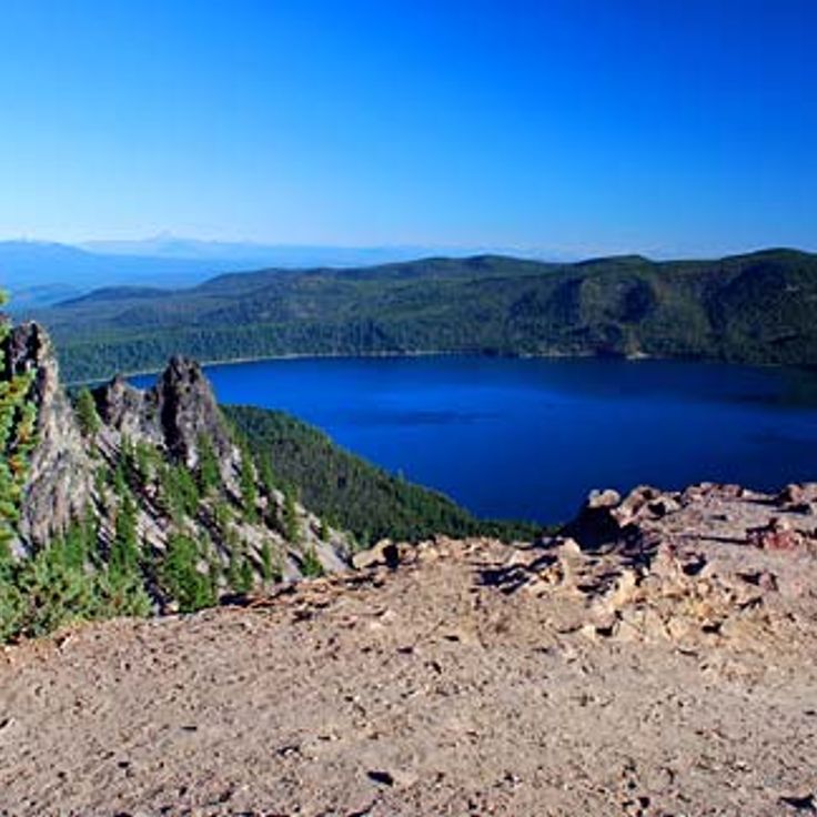
This volcanic island rises 763 feet (232 meters) above the surface of Crater Lake, forming a distinct cone with a 500-foot (150-meter) wide crater at its summit. Wizard Island formed through eruptions following the collapse of Mount Mazama approximately 7,700 years ago. Visitors can reach the island via boat tours and hike a steep trail to the summit crater. The island represents one of the geological formations that document Oregon's volcanic landscapes.
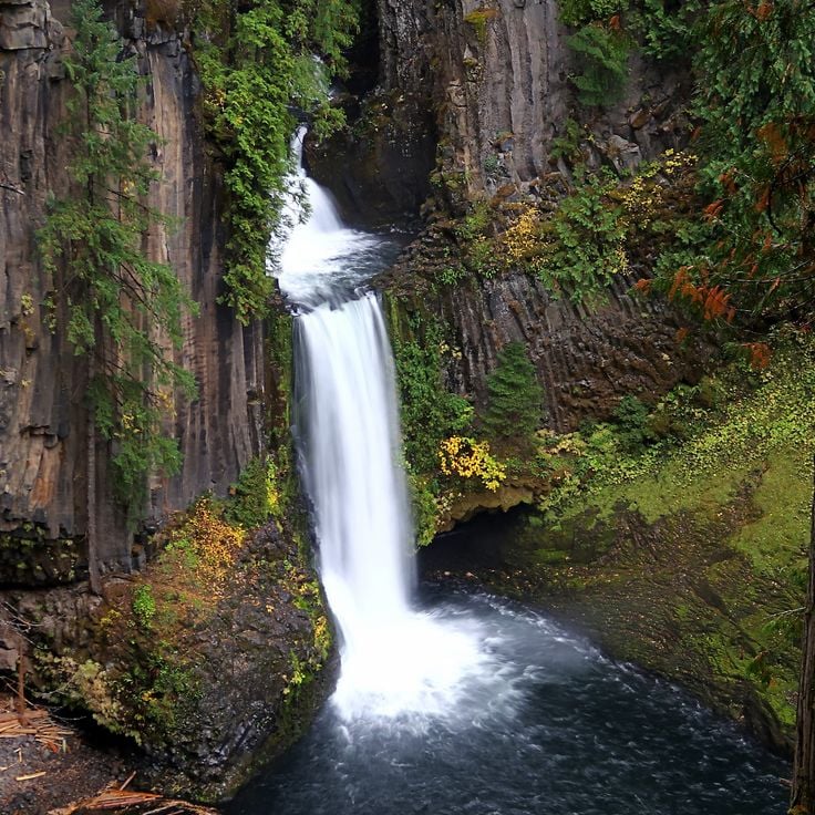
This waterfall stands among Oregon's notable geological formations, displaying two distinct tiers surrounded by a natural amphitheater of hexagonal basalt columns. Toketee Falls sits within the North Umpqua River drainage area, accessible via a short trail through coastal forest. The hexagonal basalt resulted from volcanic activity and lava cooling. The falls drop roughly 120 feet (36 meters) into a pool below.
This wilderness encompasses steep mountain slopes, glacial valleys and varied wildlife populations. Steens Mountain Wilderness sits in southeastern Oregon and displays volcanic rock layers that rise over several thousand feet. The area contains high plateaus, gorges and alpine meadows that provide different habitats for pronghorn antelope, bighorn sheep and golden eagles. Trails lead to viewpoints overlooking the Alvord Desert basin and the Great Basin.
The Samuel H. Boardman State Scenic Corridor extends for 12 miles along Oregon's southern coast and provides access to several remote beaches, offshore rock formations and clifftop trails. The corridor sits between Brookings and Gold Beach and includes natural arches, forested coastal sections and viewpoints above the Pacific Ocean. Hiking paths lead through Sitka spruce groves to coves with tide pools and rock outcrops that rise between 200 and 400 feet (60 and 120 meters) above sea level.
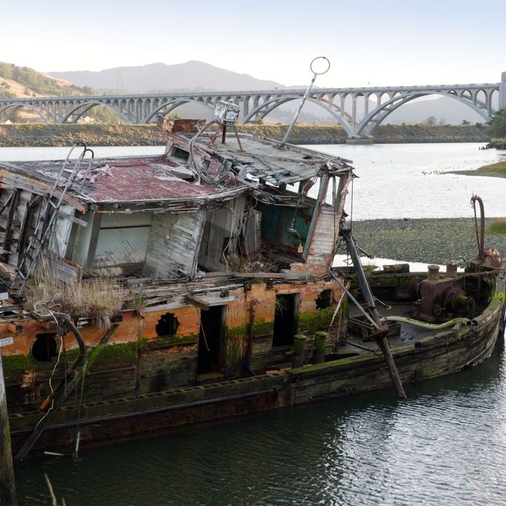
This shipwreck from the 19th century rests in the Rogue River after 104 years of service. The Mary D. Hume represents one of the few remaining steam powered vessels from that era along the Pacific Coast and documents Oregon's maritime history. The wreck lies partially submerged and continues to deteriorate, though it remains visible as an industrial monument. The ship served initially in whaling operations, then in timber transport and commercial fishing.
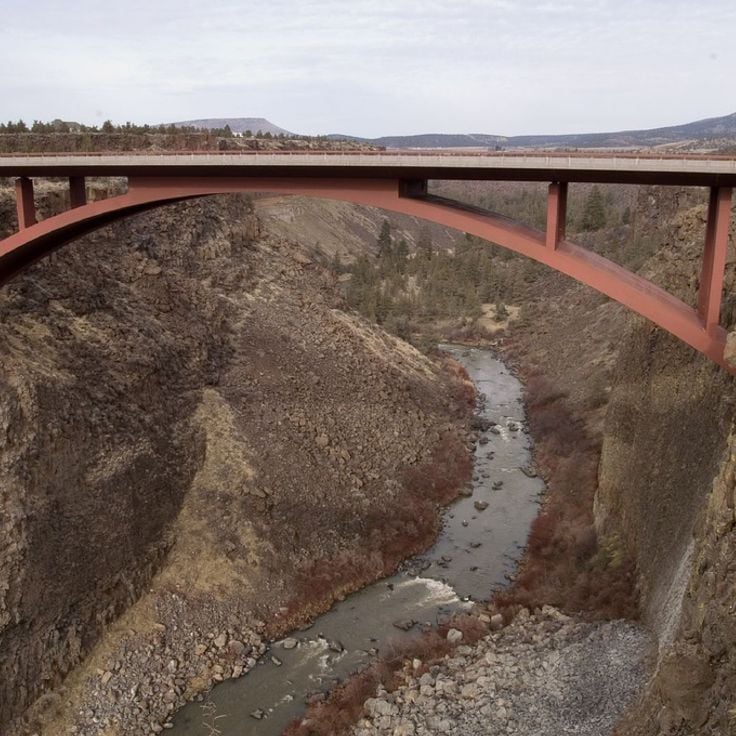
This viewpoint offers views of the Crooked River canyon, which drops 300 feet (91 meters) below, with three bridges spanning the gorge from different construction periods. The site illustrates how bridge engineering evolved from the early 20th century to present day while the winding river cuts through layers of volcanic rock. The canyon represents one of Oregon's geological formations shaped by volcanic activity and river erosion over thousands of years.
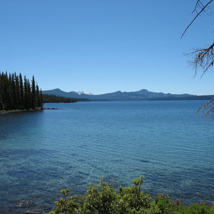
This lake sits in Willamette National Forest at 5,414 feet (1,650 meters) elevation and ranks among Oregon's notable geological formations. The water contains very low mineral content, allowing visibility to reach 157 feet (48 meters). Waldo Lake is surrounded by mountains and accessed via several hiking trails that provide entry to the region's volcanic landscapes.
This 8,000-acre (3,237-hectare) park extends along 16 miles (26 kilometers) of the John Day River and displays basalt cliffs and prairie landscapes. Cottonwood Canyon State Park sits within the river canyon and provides access to riparian areas with cottonwood groves. The terrain includes trails through grasslands and rocky sections typical of the region's geological formations.
This lava field extends across 27 square miles (70 square kilometers) of black basalt rock formed by volcanic eruptions approximately 3,200 years ago. Jordan Craters sits in southeastern Oregon and displays various volcanic formations including cinder cones, lava tubes and solidified lava flows. The terrain is accessible via unpaved roads and provides trails through the rough volcanic landscape. The area is remote and sees few visitors, with the nearest towns roughly 60 miles (97 kilometers) away. The lava field is managed by the Bureau of Land Management and represents Oregon's volcanic heritage in the High Desert country.
This wilderness sits in the Coast Range mountains and covers densely forested slopes rising to roughly 4,000 feet (1,200 meters). The area offers demanding trails through old-growth timber and steep ravines. Infrastructure remains deliberately limited to preserve its remote character. Devil's Staircase Wilderness ranks among Oregon's less visited protected areas and requires solid navigation skills.
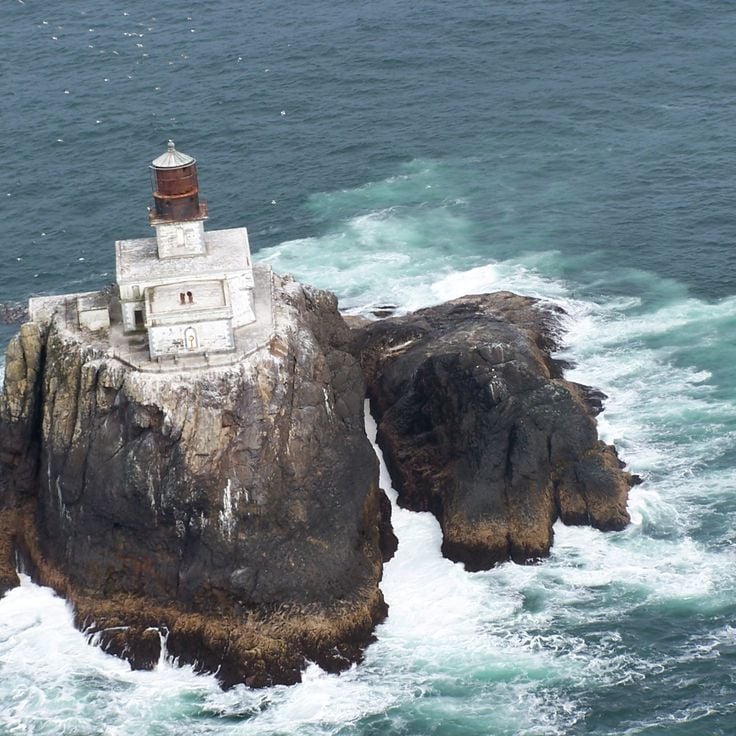
This lighthouse was built in 1881 on a rocky island located 1.2 miles (2 kilometers) off the Oregon coast in the Pacific Ocean. The remote location and severe weather conditions made construction and operation a significant engineering challenge. The structure served as a navigational aid for ships until 1957 and is part of the region's maritime history, which includes coastal sections, geological formations, and historic structures.
Munson Creek Falls presents a 95-meter (312-foot) waterfall in Tillamook County, set within a forest containing old cedar and spruce trees. This waterfall ranks among Oregon's higher cascades and is reached via a short, maintained trail that passes through dense coastal forest.
This 7,985-foot (2,434-meter) summit offers views across the Cascade Range, high desert terrain and two volcanic lakes within Oregon's geological formations and volcanic landscapes. Paulina Peak sits on the rim of Newberry Caldera and provides visitors with perspectives on the region's natural diversity, from forested volcanic slopes to the lava fields of the eastern highlands.
This state park encompasses nearly 10 miles (16 kilometers) of forest trails ascending to the 1,875-foot (570-meter) summit, which provides views across the Pacific Ocean. Humbug Mountain forms a prominent coastal peak in southern Oregon and belongs to the collection of natural and historical sites across the state that features geological formations, waterfalls, and volcanic landscapes.
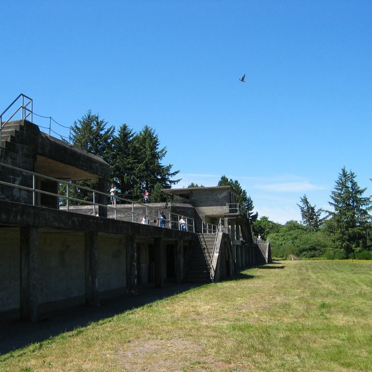
This Oregon state park preserves World War II military installations including gun batteries and bunkers along the coast. The steel skeleton of the Peter Iredale, which ran aground in 1906, rests on the beach as a reminder of the hazards of navigation along this coastline. The park spans 9 miles (14 kilometers) of sandy beach, freshwater lakes, and access to the Columbia River. Visitors explore historic fortifications, trails through coastal forest, and campgrounds overlooking the Pacific.
This coastal park occupies a rocky headland above the Pacific Ocean and offers around 2 miles of trails with views of cliffs and ocean. The former 1934 Coast Guard building now serves as a museum on maritime rescue history. Visitors find paths through coastal vegetation and can observe gray whales during their migration. The park contains the Port Orford Lifeboat Station Museum and provides access to overlooks along the bluffs.
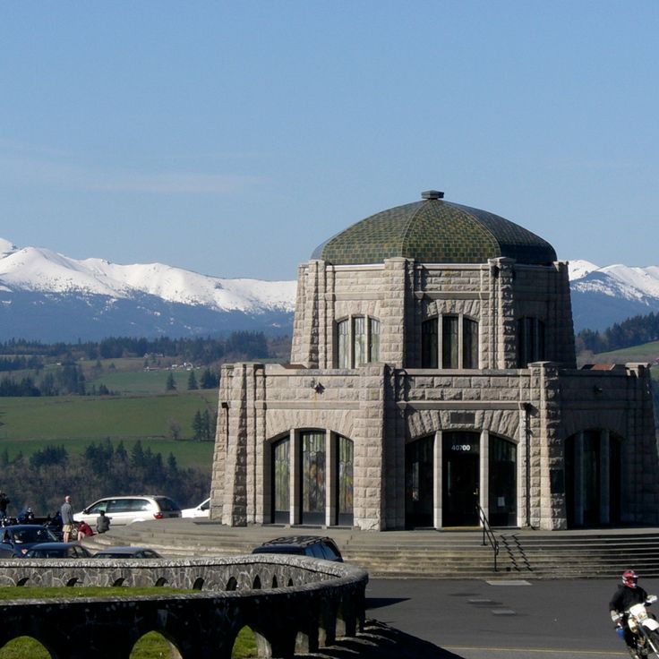
This octagonal stone building was completed in 1918 on a rocky cliff 725 feet (221 meters) above the Columbia River. Vista House at Crown Point serves as an observation tower and memorial to the Oregon Trail pioneers. The structure marks one of the highest points along the Historic Columbia River Highway and provides views of the river gorge cutting east through the Cascade Range. The building features multilevel terraces and an information center about the region's road construction history.
This rocky cove along southern Oregon's coastline contains three natural stone arches that span across the water, through which the Pacific flows. The formations resulted from erosion over thousands of years and provide habitat for sea turtles, seals, and various fish species. At low tide, visitors can explore tide pools and observe smaller marine life in the rock depressions, while the arches frame views of the open ocean.
These geothermal springs in the Cascade Mountains reach temperatures up to 136°F (58°C) and sit within an old-growth forest in Oregon's natural landscape. Wooden bathhouses made from cedar provide visitors with space for soaking in the warm mineral waters.
This 92-foot (28-meter) waterfall flows over basalt columns and ranks among Oregon's geological formations. Access to Abiqua Falls requires hiking through steep terrain with slippery sections, particularly challenging during winter and spring when water flow peaks.
This waterfall formed in 1938 when engineers blasted a tunnel through rock to build the Columbia River Highway. Water drops roughly 100 feet (30 meters) to the ground below, creating an unusual feature along the historic road route. Hole-in-the-Wall Falls demonstrates how road construction projects occasionally produce new natural attractions. The waterfall sits within the forested slopes of the Columbia River Gorge area.
This natural basin along the McKenzie River fills with turquoise water from underground springs. The Blue Pool sits roughly 3 miles (5 km) upstream from Carmen Reservoir in an area where the river runs beneath a prehistoric lava field before reemerging at the surface. The water remains at approximately 37 degrees Fahrenheit (3 degrees Celsius) year-round, and swimming is prohibited here. Hikers reach the basin via the McKenzie River Trail through Douglas fir and cedar forest.
This narrow canyon in the Columbia River Gorge leads through moss covered rock walls to a 100 foot (30 meter) waterfall. Oneonta Gorge cuts through a basalt geological section and requires wading through water. The gorge is part of the geological formations that characterize Oregon. Access follows through a stream, and visitors must climb over driftwood to reach the waterfall. The rock walls rise up to 100 feet (30 meters) and create a damp microclimate with ferns and moss.
This alpine lake in the Mount Hood National Forest features a natural drain hole that depletes water levels during spring months. Lost Lake sits at roughly 3,200 feet (975 meters) elevation and offers views of Mount Hood. The drain hole, a lava tube of volcanic origin, typically empties the lake between May and July as snowmelt and precipitation decrease. The lake refills during fall and winter through rainfall and snow. Surrounding terrain includes hiking trails through conifer forests and lakeside camping areas.
This natural area encompasses a circular volcanic crater rising 200 feet (60 meters) above the desert landscape and contains archaeological sites. Fort Rock State Natural Area represents one of Oregon's geological formations, documenting volcanic activity and early human settlement in the region. The crater formed through explosive interaction between lava and water.
The Alvord Desert covers 84 square miles (217 square kilometers) with surface temperatures reaching 104°F (40°C) during summer months. This salt flat in southeastern Oregon contrasts with the volcanic landscapes and waterfalls found elsewhere across the state. The flat expanse formed from the evaporation of a prehistoric lake and displays characteristic salt deposits across the desert floor.
This cape sits on the Lincoln County coastline and rises 800 feet above sea level. Cape Perpetua ranks among the highest coastal points in Oregon and provides access to tide pools among the rocks and several trails along the cliffs. The landscape shows typical features of the region's volcanic geology with basalt formations and coastal vegetation. From the summit, visitors overlook the Pacific Ocean and the surrounding forest areas of Siuslaw National Forest.
This trail extends roughly 2.5 miles (4 kilometers) through a coastal forest and passes several cascades. Metal walkways and viewing platforms provide access to multiple waterfalls that flow through the rugged terrain of Lane County, offering insights into Oregon's geological formations and natural water features.
The Newberry National Volcanic Monument covers more than 80 square miles (210 square kilometers) of the Cascade volcanic chain in central Oregon, encompassing geological formations that illustrate the region's volcanic history. This protected area contains Paulina Peak, two crater lakes, extensive obsidian fields and the Big Obsidian Flow, a lava formation roughly 500 feet (150 meters) deep. Visitors can explore lava tubes, walk trails through various volcanic landscapes and observe the geological processes that shaped this environment over thousands of years.
Crack in the Ground is a volcanic fissure in Lake County, Oregon, extending approximately 2 miles (3.2 kilometers) and reaching depths of 70 feet (21 meters). This geological formation resulted from cooling lava flows roughly 1,000 years ago, when contracting basalt rock fractured and created an elongated chasm across the desert landscape. The fissure demonstrates volcanic activity in the region and displays textured basalt walls along its length. Visitors can walk along the floor of the fissure, where temperatures remain cooler than the surrounding terrain even during summer months. This site represents one of Oregon's less frequented geological features and illustrates the state's volcanic history.
This region extends across 5,000 square miles (13,000 square kilometers) in remote sections of eastern Oregon with basalt cliffs rising up to 1,000 feet (300 meters) above canyon floors. The Owyhee Canyonlands contain multiple rivers and tributaries that have cut through volcanic rock to form canyon systems. The area consists of high desert plateaus, grasslands and arid sections with sparse vegetation. Hiking trails lead to viewpoints over the canyons and along river courses, while the geology displays volcanic activity dating back several million years.
This national monument sits at the convergence of three mountain ranges and hosts over 3500 plant and animal species across varied geological formations. The Cascade Siskiyou region demonstrates Oregon's natural diversity with connections between the Cascade Range, Siskiyou region, and Great Basin. The protected area covers approximately 114,000 acres (461 square kilometers) and presents ecosystems ranging from wetlands to alpine zones, accessible through hiking trails.
This canyon reaches 8000 feet (2440 meters) deep and marks the steep convergence of Oregon, Idaho and the Snake River. The Hells Canyon National Recreation Area preserves remnants of prehistoric Nez Perce settlements within the rock walls and along the plateaus, where archaeological sites document tools, petroglyphs and structural foundations. Trails traverse multiple climate zones from river level to alpine ridges. The Snake River section provides rafting through rapids between Idaho and Oregon, while higher elevations grant views across the Seven Devils Mountains and the Wallowa Range.
This 560-foot (170-meter) volcanic rock tower from the Cretaceous period rises above the Jackson County landscape and represents one of the geological features in southern Oregon. Pilot Rock formed roughly 80 million years ago through volcanic activity and now serves as a hiking destination with views of the Cascade Range. The ascent requires climbing experience for the upper sections.
Cape Meares Lighthouse is one of Oregon's historic lighthouses, built in 1890 on a 200-foot (61-meter) cliff. The structure still houses its original first-order Fresnel lens and provides access to the state's coastal landscape.
This unit of John Day Fossil Beds National Monument presents hills with red, black and gold mineral layering that documents 35 million years of geological development. The exposed formations belong to a broader collection of natural and historical sites across Oregon that includes volcanic landscapes and geological features. Visitors follow marked trails through the colored sedimentary deposits.
This volcanic island rises 763 feet (232 meters) above the surface of Crater Lake, forming a distinct cone with a 500-foot (150-meter) wide crater at its summit. Wizard Island formed through eruptions following the collapse of Mount Mazama approximately 7,700 years ago. Visitors can reach the island via boat tours and hike a steep trail to the summit crater. The island represents one of the geological formations that document Oregon's volcanic landscapes.
This waterfall stands among Oregon's notable geological formations, displaying two distinct tiers surrounded by a natural amphitheater of hexagonal basalt columns. Toketee Falls sits within the North Umpqua River drainage area, accessible via a short trail through coastal forest. The hexagonal basalt resulted from volcanic activity and lava cooling. The falls drop roughly 120 feet (36 meters) into a pool below.
This wilderness encompasses steep mountain slopes, glacial valleys and varied wildlife populations. Steens Mountain Wilderness sits in southeastern Oregon and displays volcanic rock layers that rise over several thousand feet. The area contains high plateaus, gorges and alpine meadows that provide different habitats for pronghorn antelope, bighorn sheep and golden eagles. Trails lead to viewpoints overlooking the Alvord Desert basin and the Great Basin.
The Samuel H. Boardman State Scenic Corridor extends for 12 miles along Oregon's southern coast and provides access to several remote beaches, offshore rock formations and clifftop trails. The corridor sits between Brookings and Gold Beach and includes natural arches, forested coastal sections and viewpoints above the Pacific Ocean. Hiking paths lead through Sitka spruce groves to coves with tide pools and rock outcrops that rise between 200 and 400 feet (60 and 120 meters) above sea level.
This shipwreck from the 19th century rests in the Rogue River after 104 years of service. The Mary D. Hume represents one of the few remaining steam powered vessels from that era along the Pacific Coast and documents Oregon's maritime history. The wreck lies partially submerged and continues to deteriorate, though it remains visible as an industrial monument. The ship served initially in whaling operations, then in timber transport and commercial fishing.
This viewpoint offers views of the Crooked River canyon, which drops 300 feet (91 meters) below, with three bridges spanning the gorge from different construction periods. The site illustrates how bridge engineering evolved from the early 20th century to present day while the winding river cuts through layers of volcanic rock. The canyon represents one of Oregon's geological formations shaped by volcanic activity and river erosion over thousands of years.
This lake sits in Willamette National Forest at 5,414 feet (1,650 meters) elevation and ranks among Oregon's notable geological formations. The water contains very low mineral content, allowing visibility to reach 157 feet (48 meters). Waldo Lake is surrounded by mountains and accessed via several hiking trails that provide entry to the region's volcanic landscapes.
This 8,000-acre (3,237-hectare) park extends along 16 miles (26 kilometers) of the John Day River and displays basalt cliffs and prairie landscapes. Cottonwood Canyon State Park sits within the river canyon and provides access to riparian areas with cottonwood groves. The terrain includes trails through grasslands and rocky sections typical of the region's geological formations.
This lava field extends across 27 square miles (70 square kilometers) of black basalt rock formed by volcanic eruptions approximately 3,200 years ago. Jordan Craters sits in southeastern Oregon and displays various volcanic formations including cinder cones, lava tubes and solidified lava flows. The terrain is accessible via unpaved roads and provides trails through the rough volcanic landscape. The area is remote and sees few visitors, with the nearest towns roughly 60 miles (97 kilometers) away. The lava field is managed by the Bureau of Land Management and represents Oregon's volcanic heritage in the High Desert country.
This wilderness sits in the Coast Range mountains and covers densely forested slopes rising to roughly 4,000 feet (1,200 meters). The area offers demanding trails through old-growth timber and steep ravines. Infrastructure remains deliberately limited to preserve its remote character. Devil's Staircase Wilderness ranks among Oregon's less visited protected areas and requires solid navigation skills.
This lighthouse was built in 1881 on a rocky island located 1.2 miles (2 kilometers) off the Oregon coast in the Pacific Ocean. The remote location and severe weather conditions made construction and operation a significant engineering challenge. The structure served as a navigational aid for ships until 1957 and is part of the region's maritime history, which includes coastal sections, geological formations, and historic structures.
Munson Creek Falls presents a 95-meter (312-foot) waterfall in Tillamook County, set within a forest containing old cedar and spruce trees. This waterfall ranks among Oregon's higher cascades and is reached via a short, maintained trail that passes through dense coastal forest.
This 7,985-foot (2,434-meter) summit offers views across the Cascade Range, high desert terrain and two volcanic lakes within Oregon's geological formations and volcanic landscapes. Paulina Peak sits on the rim of Newberry Caldera and provides visitors with perspectives on the region's natural diversity, from forested volcanic slopes to the lava fields of the eastern highlands.
This state park encompasses nearly 10 miles (16 kilometers) of forest trails ascending to the 1,875-foot (570-meter) summit, which provides views across the Pacific Ocean. Humbug Mountain forms a prominent coastal peak in southern Oregon and belongs to the collection of natural and historical sites across the state that features geological formations, waterfalls, and volcanic landscapes.
This Oregon state park preserves World War II military installations including gun batteries and bunkers along the coast. The steel skeleton of the Peter Iredale, which ran aground in 1906, rests on the beach as a reminder of the hazards of navigation along this coastline. The park spans 9 miles (14 kilometers) of sandy beach, freshwater lakes, and access to the Columbia River. Visitors explore historic fortifications, trails through coastal forest, and campgrounds overlooking the Pacific.
This coastal park occupies a rocky headland above the Pacific Ocean and offers around 2 miles of trails with views of cliffs and ocean. The former 1934 Coast Guard building now serves as a museum on maritime rescue history. Visitors find paths through coastal vegetation and can observe gray whales during their migration. The park contains the Port Orford Lifeboat Station Museum and provides access to overlooks along the bluffs.
This octagonal stone building was completed in 1918 on a rocky cliff 725 feet (221 meters) above the Columbia River. Vista House at Crown Point serves as an observation tower and memorial to the Oregon Trail pioneers. The structure marks one of the highest points along the Historic Columbia River Highway and provides views of the river gorge cutting east through the Cascade Range. The building features multilevel terraces and an information center about the region's road construction history.