Chest opened
+${chestReward.xp} XP
Explorer
NOUVEAU ×${chestReward.collectible.quantity}
tapez pour fermer
Chest locked

Open chests in the app

Around Us is built for your phone — chests unlock when you walk, explore and capture nearby places.

Enable Location

We need your location to show you interesting places around you

Discover nearby places

Find interesting locations and hidden gems around you

Precise directions

Get accurate directions and distances to places

Your location is never shared with other users. It's only used when you tap the location button.

Log in to your account

Start exploring — it's free

Trusted by 73,022 travelers worldwide

Continue with Google
Continue with Apple
or

We will send you a code to connect

By continuing, you accept our Terms and Conditions and our Privacy Policy

Check your inbox

We've sent a pincode in your inbox. Please enter the code below.

Quincy-Columbia Basin Irrigation District
Discussion Reviews Photo
1.6k Popularity

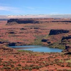
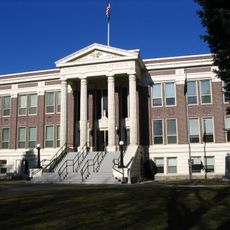
Quincy-Columbia Basin Irrigation District, Irrigation district in central Washington, United States.

The Quincy-Columbia Basin Irrigation District is a water management organization serving agricultural land across Grant County and parts of Adams County. It operates an irrigation infrastructure that delivers water to hundreds of thousands of acres used for farming.

The district was created as part of the Columbia Basin Project, which transformed irrigation in the region during the post-war period. It operates under an agreement with the U.S. Bureau of Reclamation to deliver water supplied by the Grand Coulee Dam.

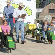
Farmers throughout the district grow a wide range of crops including alfalfa, wheat, soybeans, mint, potatoes, corn, and fruit, shaping the agricultural character of the region.

You can visit offices in Quincy and Royal City to ask about water management and irrigation services for the area. Staff members there can answer questions about how the water system works locally.

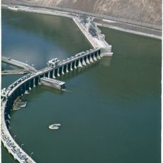
Beyond irrigation, the district partners with the Grand Coulee Hydropower Authority to generate electricity at the Quincy Chute. This dual function means the water system also powers local communities.

The community of curious travelers

AroundUs brings together thousands of curated places, local tips, and hidden gems, enriched daily by 60,000 contributors worldwide.

Start exploring
Location
GPS coordinates
47.08330,-119.66700
Latest update
December 14, 2025 13:02
Around this place
The Gorge Amphitheatre
United States of America

The Gorge Amphitheatre

24.9 km
B Reactor
United States of America

B Reactor

50.5 km
Ginkgo Petrified Forest State Park
United States of America

Ginkgo Petrified Forest State Park

29.6 km
Moses Lake
United States of America

Moses Lake

25.3 km
Iron Horse State Park
United States of America

Iron Horse State Park

44.7 km
Grandfather Cuts Loose the Ponies
United States of America

Grandfather Cuts Loose the Ponies

25.9 km
Potholes State Park
United States of America

Potholes State Park

26.6 km
Wanapum Dam
United States of America

Wanapum Dam

32.7 km
Potholes Reservoir
United States of America

Potholes Reservoir

30.6 km
Priest Rapids Dam
United States of America

Priest Rapids Dam

52.3 km
Wild Horse Wind and Solar Facility
United States of America

Wild Horse Wind and Solar Facility

42.3 km
Drumheller Channels National Natural Landmark
United States of America

Drumheller Channels National Natural Landmark

37.7 km
Rock Island Dam
United States of America

Rock Island Dam

43.3 km
Whiskey Dick Mountain
United States of America

Whiskey Dick Mountain

43.3 km
Abraham Lincoln
United States of America

Abraham Lincoln

54.2 km
Vantage Bridge
United States of America

Vantage Bridge

27.6 km
Columbia National Wildlife Refuge
United States of America

Columbia National Wildlife Refuge

27.7 km
Lake Lenore Caves State Park
United States of America

Lake Lenore Caves State Park

44.2 km
Beverly Railroad Bridge
United States of America

Beverly Railroad Bridge

35.3 km
Priest Rapids
United States of America

Priest Rapids

43.3 km
Vernita Bridge
United States of America

Vernita Bridge

49.3 km
Rock Island Railroad Bridge
United States of America

Rock Island Railroad Bridge

48.4 km
Wanapum Lake
United States of America

Wanapum Lake

32.9 km
Canada

Sentinel Gap

37 km
Surf 'n Slide Water Park
United States of America

Surf 'n Slide Water Park

29.7 km
Grant County Courthouse
United States of America

Grant County Courthouse

27.9 km
Grant County Fairgrounds
United States of America

Grant County Fairgrounds

28.1 km
Moses Lake Museum & Art Center
United States of America

Moses Lake Museum & Art Center

30.2 km
Show the full map
Reviews
Share your experience

No review yet

Discussions
Start a discussion...

No discussion yet

« Quincy-Columbia Basin Irrigation District - Irrigation district in central Washington, United States » is provided by Around Us (aroundus.com). Images and texts are derived from Wikimedia project under a Creative Commons license. You are allowed to copy, distribute, and modify copies of this page, under the conditions set by the license, as long as this note is clearly visible.

Discover hidden gems everywhere you go!

From secret cafés to breathtaking viewpoints, skip the crowded tourist spots and find places that match your style. Our app makes it easy with voice search, smart filtering, route optimization, and insider tips from travelers worldwide. Download now for the complete mobile experience.

Around Us App Screenshot

A unique approach to discovering new places

Le Figaro

All the places worth exploring

France Info

A tailor-made excursion in just a few clicks

20 Minutes

Around Us
Travel Guide & Maps
Download

Send to your phone

QR Code
1

Open the camera app on your mobile.

2

Point at the QR code with your camera. A notification will appear.

3

Tap the notification to open the link.