Enable Location

We need your location to show you interesting places around you

Discover nearby places

Find interesting locations and hidden gems around you

Precise directions

Get accurate directions and distances to places

Your location is never shared with other users. It's only used when you tap the location button.

Log in to your account

Start exploring — it's free

Trusted by 62,375 travelers worldwide

Continue with Google
Continue with Apple
or

We will send you a code to connect

By continuing, you accept our Terms and Conditions and our Privacy Policy

Check your inbox

We've sent a pincode in your inbox. Please enter the code below.

Bu Gia Map National Park

Bu Gia Map National Park, National park in Bình Phước Province, Vietnam

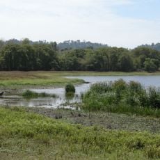
Bu Gia Map National Park is a protected forest reserve in Bình Phước Province covering primary woodland with areas reaching up to 700 meters in elevation. Two main rivers flow through the park, creating corridors of water and habitat throughout the landscape.

The park was officially established in 2002, elevating an existing conservation area to national park status. This transformation marked a turning point for protecting endangered species in the region.

Local communities have long valued this forest for medicinal plants used in traditional healing methods passed down through generations. Visitors can see how the forest remains integral to local knowledge and practices today.

Visitors must explore the park with a local guide who knows the trails and safety procedures. The best time to visit is from November to April, when dry weather makes hiking more comfortable.

The park is home to rare primates including a distinctive species with black coloring found in very few other locations. These animals make the place particularly valuable for wildlife researchers and visitors seeking to observe them.

The community of curious travelers

AroundUs brings together thousands of curated places, local tips, and hidden gems, enriched daily by 60,000 contributors worldwide.

Start exploring
Location
Elevation above the sea
633 m
GPS coordinates
12.21667,107.15000
Latest update
December 10, 2025 16:30
« Bu Gia Map National Park - National park in Bình Phước Province, Vietnam » is provided by Around Us (aroundus.com). Images and texts are derived from Wikimedia project under a Creative Commons license. You are allowed to copy, distribute, and modify copies of this page, under the conditions set by the license, as long as this note is clearly visible.

Discover hidden gems everywhere you go!

From secret cafés to breathtaking viewpoints, skip the crowded tourist spots and find places that match your style. Our app makes it easy with voice search, smart filtering, route optimization, and insider tips from travelers worldwide. Download now for the complete mobile experience.

Around Us App Screenshot

A unique approach to discovering new places

Le Figaro

All the places worth exploring

France Info

A tailor-made excursion in just a few clicks

20 Minutes

Around Us
Travel Guide & Maps
Download

Send to your phone

QR Code
1

Open the camera app on your mobile.

2

Point at the QR code with your camera. A notification will appear.

3

Tap the notification to open the link.