See the monuments around you in AROpen chests in the app
Around Us is built for your phone — point your camera at the streets and discover the monuments and places around you in augmented reality.Around Us is built for your phone — chests unlock when you walk, explore and capture nearby places.
Geological formations: rock structures, caves, thermal springs
This collection presents geological formations created through natural processes over millions of years. From layered sandstone waves in Arizona to volcanic basalt columns in Northern Ireland, these locations demonstrate Earth's geological diversity. Erosion, tectonic activity, and mineral deposits have shaped landscapes that provide insights into our planet's history.
The selection includes limestone caves in New Zealand with glowworms, thermal springs in Turkey with travertine terraces, and colored rock formations in China created by iron-rich minerals. Visitors will find glacier caves in Iceland, canyons in Utah, and salt pans in Namibia. Each location documents specific geological processes and offers opportunities to explore different rock formations and natural phenomena.
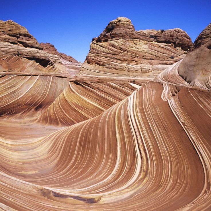
This sandstone formation in the Vermilion Cliffs displays striking red and orange layers shaped by erosional processes over millions of years. The Wave consists of Jurassic Navajo sandstone with undulating structures created by wind and water erosion. The parallel lines document different depositional periods in what was once a desert landscape. Access is limited to 20 people daily to protect the geological formation. The rock layers contain iron oxide compounds responsible for the characteristic coloring.
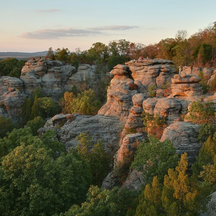
This geological formation in Shawnee National Forest displays sandstone structures spanning 1600 acres (647 hectares). The rocks and cliffs of Garden of the Gods formed through millions of years of erosion, creating distinct formations. Hiking trails wind between the sandstone structures, allowing visitors to observe the geological features at close range.
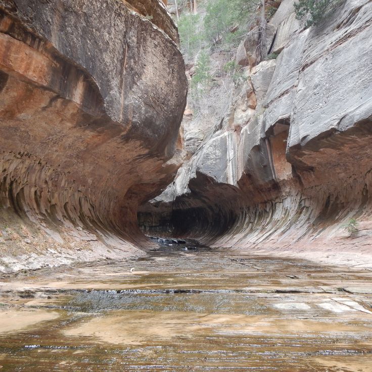
The Subway is a tube-shaped slot canyon with red rock walls and waterfalls in Zion National Park, formed by natural erosion processes. This geological formation demonstrates the transformative power of water over millions of years, carving the Navajo Sandstone into a narrow, winding passage. The canyon walls display complex layering and color variations that reflect different mineral compositions and periods of deposition. Water continues to flow through the formation, contributing to the ongoing shaping of its distinctive geometry.
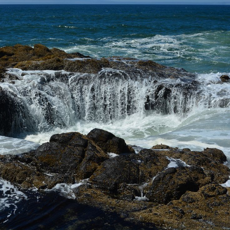
Thor's Well is a roughly 20-foot-deep (6-meter) depression in basalt rock that draws in seawater during high tide and expels it during low tide. This geological formation on the Pacific coast formed through the erosion of volcanic rock and the continuous action of waves and tides. The opening in the rock creates a natural pumping system where water circulates through the crater. The formation demonstrates the ongoing geological processes that shape coastal landscapes and represents an example of the interaction between volcanic structures and ocean erosion.
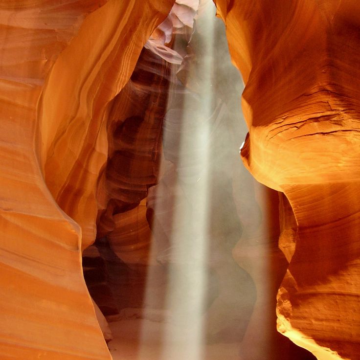
Antelope Canyon demonstrates the power of water erosion, which carved narrow, winding passages through red Navajo sandstone walls over millions of years. This geological formation near Page developed through seasonal flash floods that abraded and smoothed the soft sandstone rock. The passages reach depths of approximately 120 feet (37 meters) below the surface, with some corridors measuring only a few feet wide at their narrowest points. Light entering through openings at the surface creates shifting colors and shadows on the undulating rock walls.
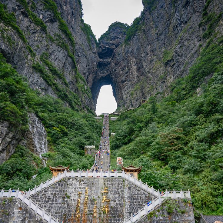
Tianmen Mountain is a geological formation in Zhangjiajie, marked by a natural arch located at 4265 feet above sea level. This opening in the limestone massif formed through thousands of years of erosion that carved away softer rock, creating a passage approximately 197 feet high and 187 feet wide. A winding mountain road with 99 switchbacks connects the valley floor to the summit plateau, ascending more than 3280 feet over a distance of 6.8 miles. The steep limestone walls display distinct layering from different geological periods.
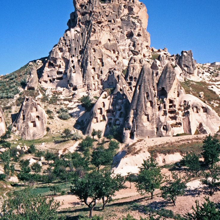
This volcanic landscape in central Anatolia displays cone-shaped tuff stone formations created by the erosion of volcanic ash deposits. The soft rock layers allowed people to carve dwellings and churches into the formations for centuries. The underground cities and rock-cut churches of Cappadocia demonstrate the geological malleability of tuff stone, which was deposited millions of years ago through volcanic activity. The characteristic fairy chimneys and valleys formed through differential erosion between harder and softer rock layers.
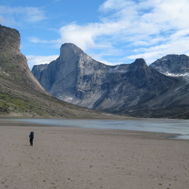
Mount Thor rises from Baffin Island and presents a vertical granite cliff face that drops over 4100 feet (1250 meters). This geological formation developed through glacial erosion during the last ice age, when glaciers carved away surrounding rock and left the steep cliff behind. The mountain extends across an area of about 40 square miles (105 square kilometers) and demonstrates the result of millions of years of geological processes in Canada's Arctic region.
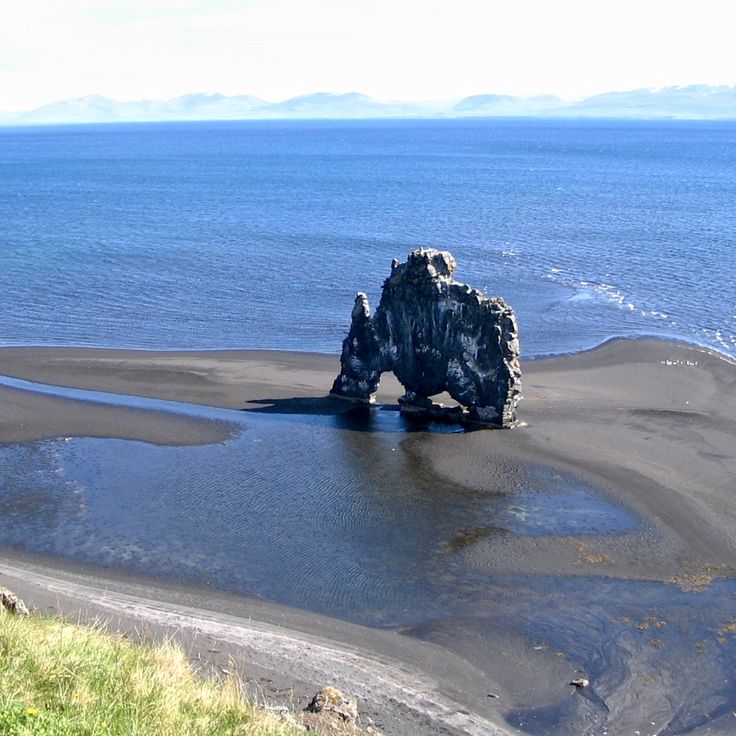
Hvitserkur is a 15-meter (49-foot) basalt formation on the coast of Vatnsnes shaped by millions of years of erosion. This rock structure rises from the sea and resembles the form of a drinking animal. The base has been reinforced with concrete to prevent further erosion from waves and tides. The geological formation demonstrates volcanic activity and the ongoing effects of marine processes on basalt rock.
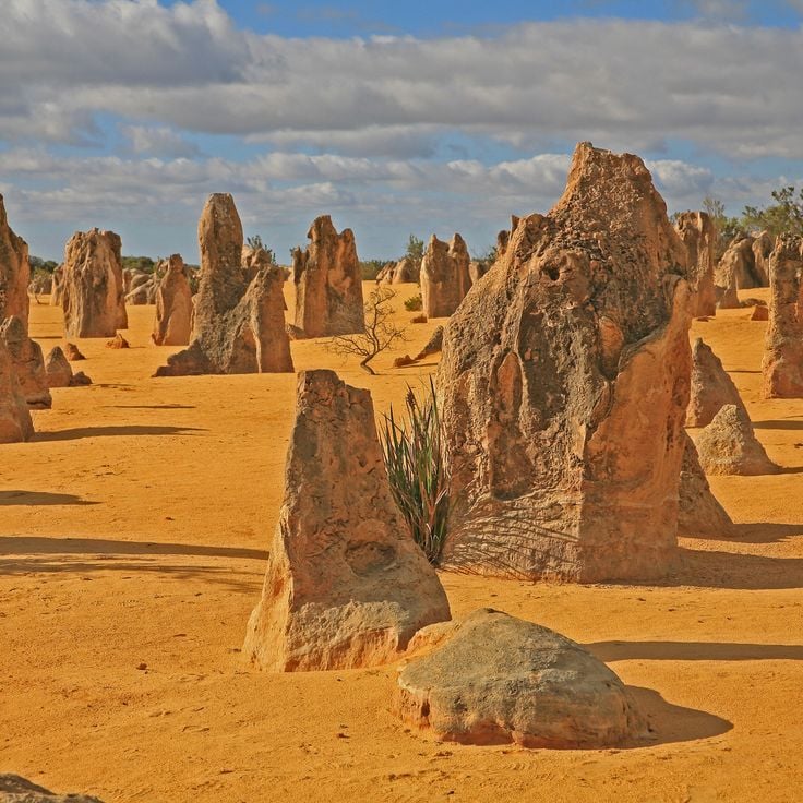
These limestone pillars rise from yellow sand in the Nambung Desert and document geological processes that developed over millions of years. The Pinnacles formed through the petrification of tree trunks and subsequent erosion of surrounding sediments. The vertical formations vary in height and shape, with some reaching several yards tall. The area displays thousands of these structures, shaped by calcium deposits and wind. The yellow color of the sand results from iron-bearing minerals. The Pinnacles demonstrate the interaction between organic material, mineral deposits, and erosional forces in this geological structure.
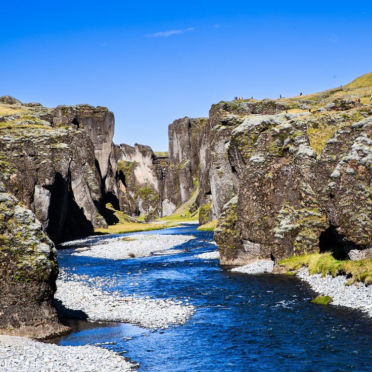
This canyon extends for two miles and reaches a depth of approximately 330 feet (100 meters). Fjadrargljufur formed during the last ice age as glacial meltwater carved through volcanic rock. The steep walls display layers of basalt and palagonite shaped by repeated erosion. The Fjadra River flows at the canyon floor, having cut the winding path through the bedrock over thousands of years. The geological formation documents glacial and fluvial processes that shaped Iceland's landscape during and after the ice age.
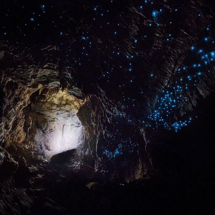
These caves house millions of Arachnocampa luminosa, a species of fungus gnat endemic to New Zealand. The larvae of these insects produce bioluminescent blue light on the cave ceilings as they attract prey with glowing silk threads. The cave system formed approximately 30 million years ago through limestone dissolution and erosion. The Waitomo Caves extend across several miles of underground galleries and rivers, with the Glowworm Grotto representing the most concentrated area of these luminescent organisms. The constant cave climate with high humidity allows the larvae to survive during their several-month developmental phase.
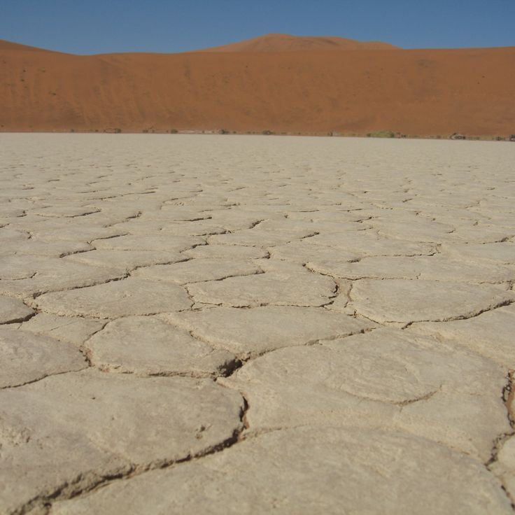
Deadvlei is a dried clay basin within Namib-Naukluft National Park, known for its black acacia stumps surrounded by tall red dunes. The basin formed around 900 years ago when the Tsauchab River changed course, leaving the trees to die from lack of water. The intense heat and aridity have preserved the trees without allowing them to decay. The surrounding dunes are among the tallest in the world, reaching heights of over 980 feet (300 meters). The contrast between the dark tree skeletons, white clay floor, and rust-colored dunes makes this geological formation a distinctive example of desert processes.
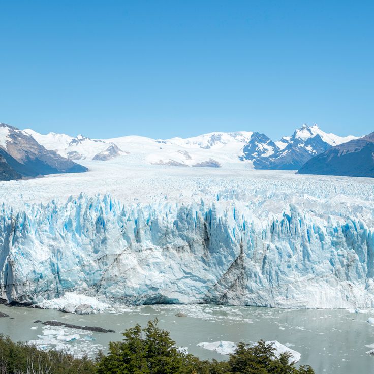
This glacier extends for 19 miles (30 kilometers) with a 3-mile (5-kilometer) wide front that advances from the Southern Patagonian Ice Field. The formation demonstrates active glacial processes where large ice pieces regularly calve from the terminal face into Lago Argentino. Perito Moreno Glacier represents one of the few glaciers worldwide maintaining an equilibrium state where ice accumulation balances melting processes. The ice mass reaches heights up to 240 feet (74 meters) above water level and documents geological climate processes spanning millennia.
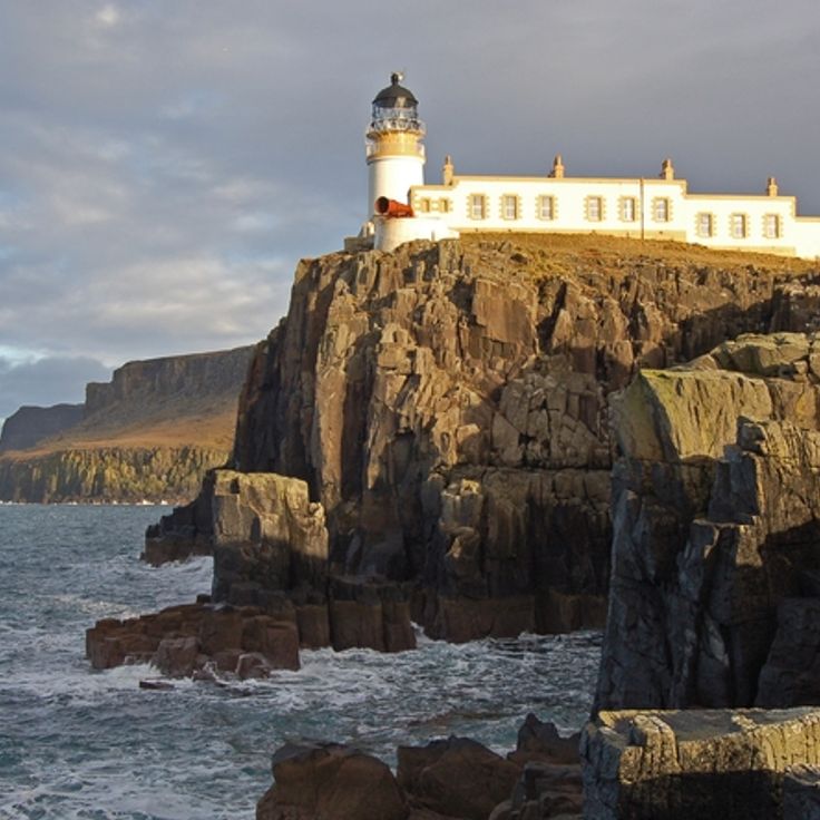
Neist Point is the westernmost cape of the Isle of Skye and displays geological layering of volcanic rock formed during the Tertiary period. The cliffs rise 328 feet (100 meters) above the sea and reveal basalt formations shaped by erosion and tectonic processes. A lighthouse built in 1909 stands at the end of the rocky peninsula, where the geological structures face marine weathering processes. The rock formations document volcanic activity that shaped this region millions of years ago and contributed to the formation of the distinctive coastal geology.
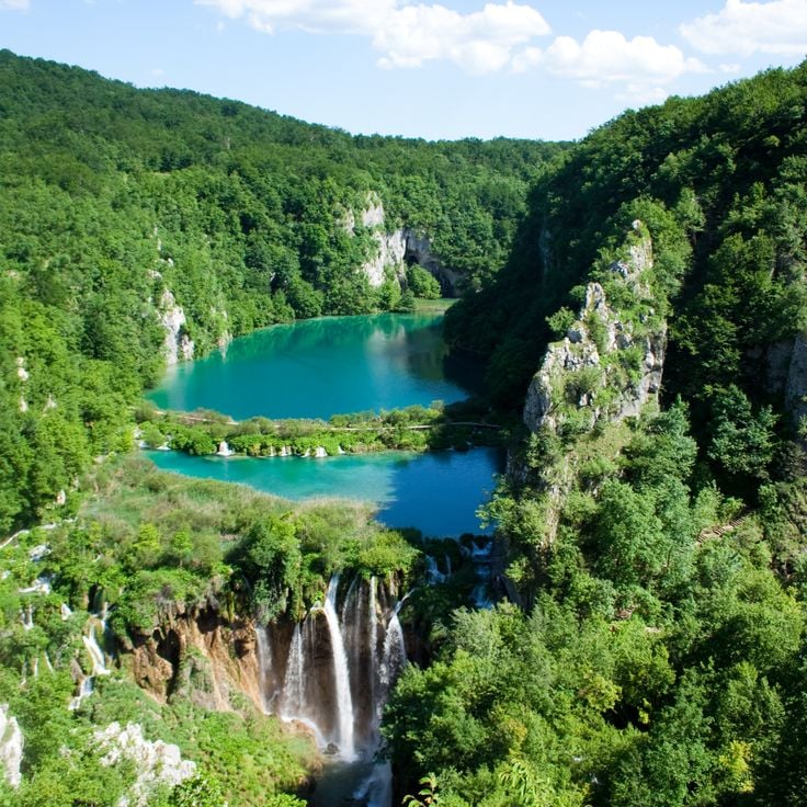
This national park comprises a system of 16 terraced lakes connected by waterfalls and underground karst rivers. Plitvice Lakes formed through calcium carbonate deposits over thousands of years, creating natural travertine barriers that separate individual basins. The geological system demonstrates the interaction between water, rock, and organic processes. The lakes sit at different elevations between the upper and lower sections of the park, with water flowing continuously from one basin to the next through a series of cascades and subterranean channels.
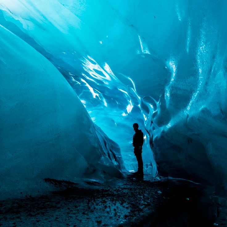
These natural tunnels form when meltwater flows through the glacier ice of Vatnajokull. The walls display various shades of blue and ice patterns shaped by the pressure and compaction of snow over centuries. Vatnajokull covers an area of approximately 3,100 square miles (8,100 square kilometers), making it the largest glacier in Europe. The ice caves are temporary geological formations that reform and change each year as meltwater streams carve new paths through the ice.
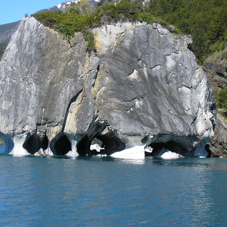
These marble caves consist of limestone formations shaped over a period of 6,000 years by the waters of Lake General Carrera. The geological structures demonstrate the result of continuous water erosion, where waves and currents gradually wore away the soft carbonate rock. The caves display smooth, undulating surfaces created by the mechanical action of the lake water. The turquoise water of the lake reflects against the cave walls, creating shifting color patterns. The formation sits at the edge of one of South America's largest lakes and is accessible only by boat.
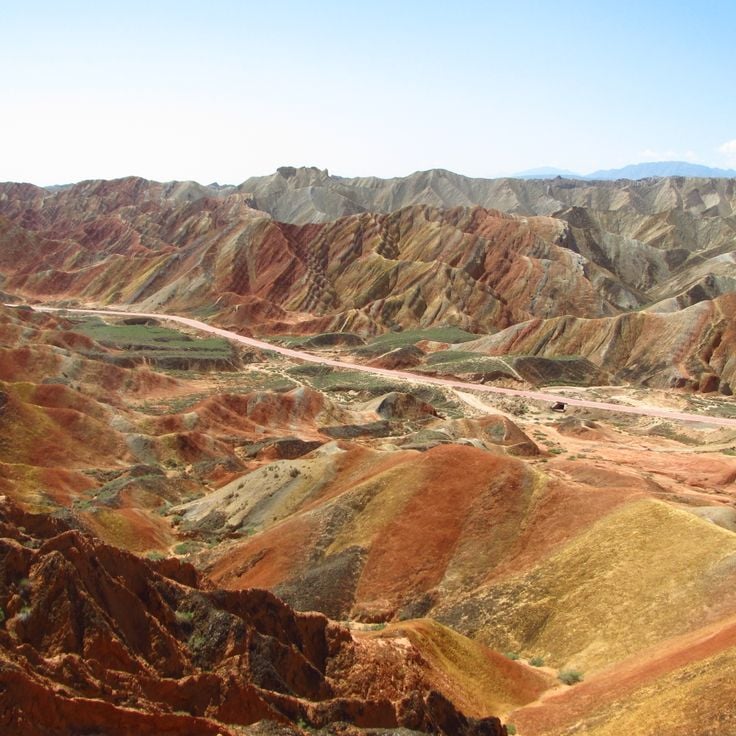
This geological formation in the Zhangye Danxia National Park displays layered red sandstone colored by iron oxides, along with yellow, orange and green stripes created by various mineral deposits. The multicolored rock layers formed over 24 million years through the deposition of sandstone and siltstone, followed by tectonic uplift and erosion. The landform covers approximately 193 square miles (500 square kilometers) and reaches heights of up to 1600 feet (490 meters) above the valley floor. The different colors result from oxidized iron and other minerals deposited under varying climatic conditions.
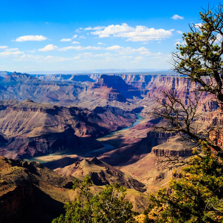
This canyon extends 277 miles (446 kilometers) through Arizona and reveals rock layers cut by a river over millions of years. The gorge reaches depths exceeding 6,000 feet (1,800 meters) and exposes a geological record spanning nearly two billion years. The different sedimentary strata display distinct epochs of Earth's history, from Precambrian formations to more recent deposits. The Colorado River shaped this geological structure through continuous erosion, creating one of the most significant exposures of tectonic and sedimentary processes in North America.
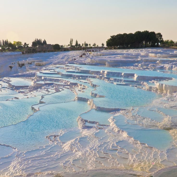
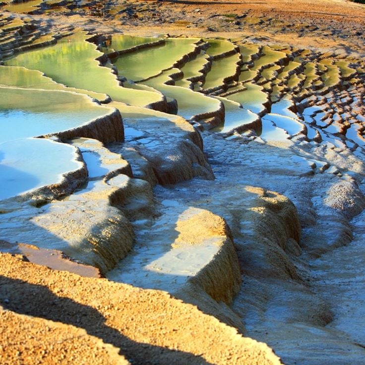
These thermal springs formed through mineral-rich water flowing down the mountain slope over thousands of years, creating the distinctive white limestone formations of Pamukkale. The water carries calcium carbonate from underground sources to the surface, where it crystallizes upon cooling and forms the terraced pools and travertine deposits. The geological processes that created this formation remain active today, continuously adding new layers to the existing limestone structure. The springs reach temperatures of approximately 95 degrees Fahrenheit (35 degrees Celsius) and have attracted people since ancient times.
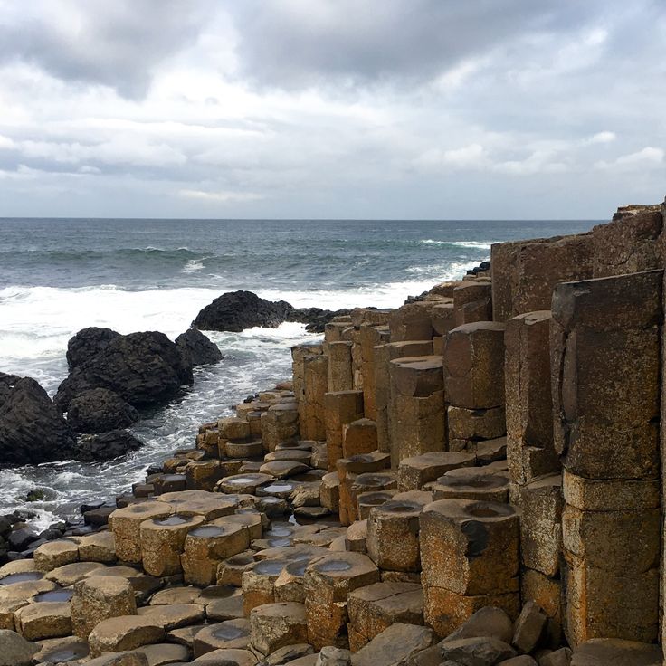
The Giant's Causeway consists of approximately 40,000 hexagonal basalt columns formed 60 million years ago through intense volcanic activity. This coastal geological structure in County Antrim displays the processes of solidified lava flows, where molten rock cooled and fractured into distinctive prismatic shapes. The columns reach heights of up to 39 feet (12 meters) and extend from the cliff face into the sea, where they become visible at low tide.
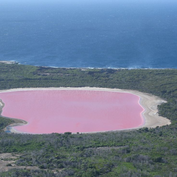
This saltwater lake on Middle Island displays pink coloration caused by the algae species Dunaliella salina and high salinity levels. Lake Hillier extends approximately 2,000 feet (600 meters) in length within the Recherche Archipelago. The pink hue remains even when water is removed from the lake. The geological formation resulted from marine processes and mineral deposition over extended periods. A narrow strip of sand separates the lake from the Southern Ocean, while dense vegetation surrounds its perimeter. The coloration demonstrates the interaction between microorganisms and extreme environmental conditions in this natural formation.
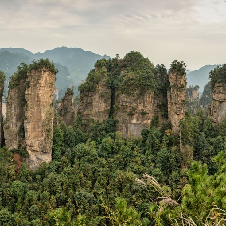
This stone forest area contains more than 3000 narrow sandstone pillars and peaks in Hunan Province, some rising over 650 feet (200 meters) high. The formations developed through physical erosion processes over millions of years. The geological structure displays various stages of weathering and removal of sandstone layers. The area demonstrates the diversity of Earth processes shaped by water and wind action.
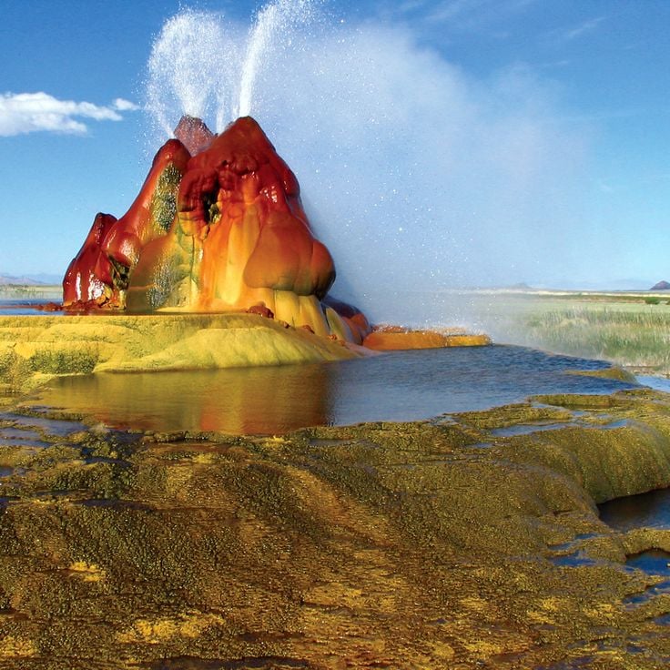
This geothermal geyser is an accidental geological structure created in 1964 through drilling attempts. Fly Geyser continuously releases mineral-rich water at approximately 200°F (93°C) from several openings. The expelled minerals formed terraced calcium carbonate deposits over decades, colored red, green, and orange by thermophilic algae. The formation reaches approximately 5 feet (1.5 meters) in height and continues growing through ongoing mineral deposition that shapes characteristic cones.
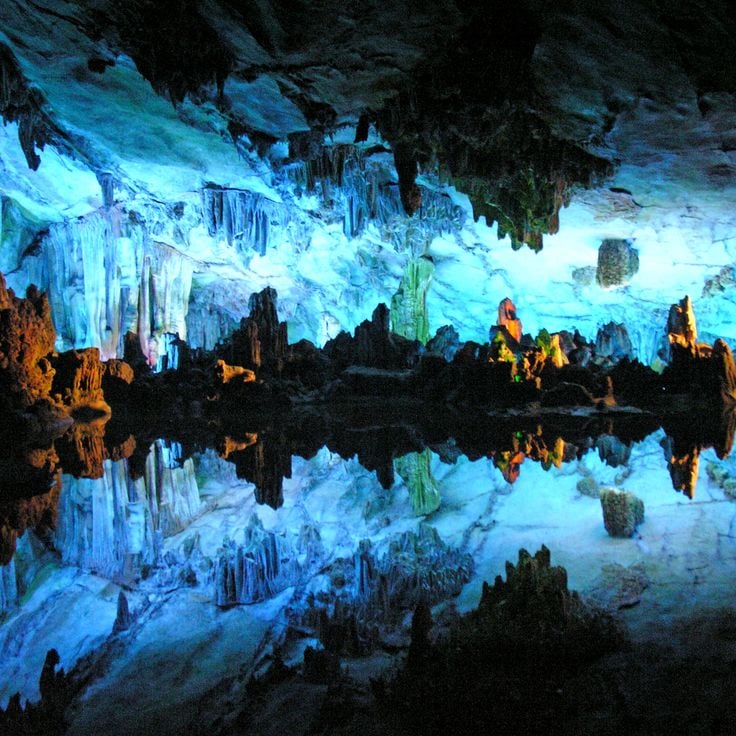
This 180-million-year-old limestone cave extends 787 feet (240 meters) underground. Reed Flute Cave displays stalactites, stalagmites, and other geological formations created through erosion and mineral deposits. Colored LED lighting highlights the natural structures within the cave, revealing the various rock layers that formed over geological time periods. The cave system demonstrates the ongoing processes of carbonate dissolution and precipitation that shape such subterranean environments.
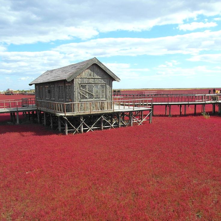
This coastal marsh in Panjin spans 2,400 acres (970 hectares) and turns red each autumn when Suaeda salsa, a salt-tolerant plant, develops its characteristic red coloration. The wetland formed through sediment deposits from the Liaohe River and provides habitat for numerous waterbirds. The geological formation demonstrates the interaction between river dynamics and tidal influence, where salt concentration in the soil enables growth of specialized vegetation. The area exhibits geological processes of coastal morphology and sediment formation.
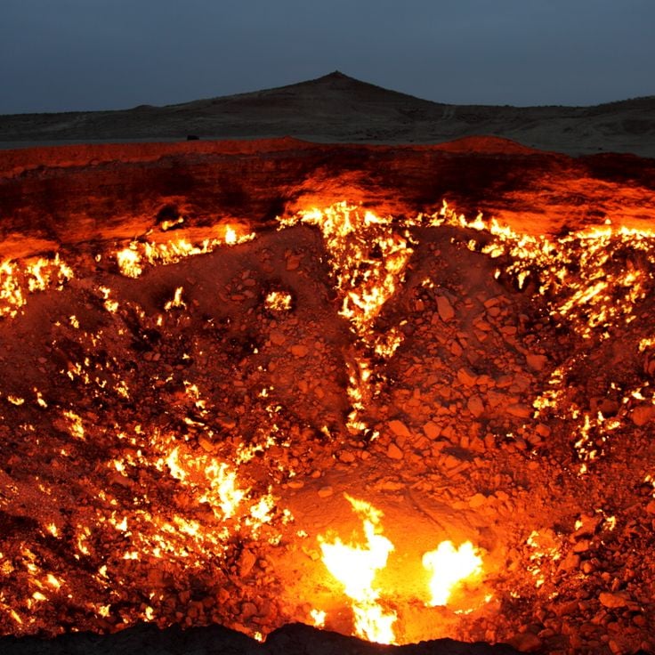
This crater formed in 1971 when Soviet geologists ignited an underground cavern of natural gas to prevent methane spread. The Door to Hell measures 230 feet (70 meters) wide and has burned continuously for over five decades. The fire within the crater is fueled by the ongoing release of natural gas from the reservoir below. This geological formation demonstrates the consequences of human intervention in natural gas deposits and shows the longevity of burning natural gas sources in the Karakum Desert.
This grotto consists of two connected caves extending over six kilometers, formed through limestone dissolution. Underground rivers have created stalagmites, stalactites, and other mineral formations over thousands of years. The upper cave is accessible by foot, while the lower features an active waterway navigable by boat. The system demonstrates geological processes of carbonate formation and mineral deposition typical of the region.
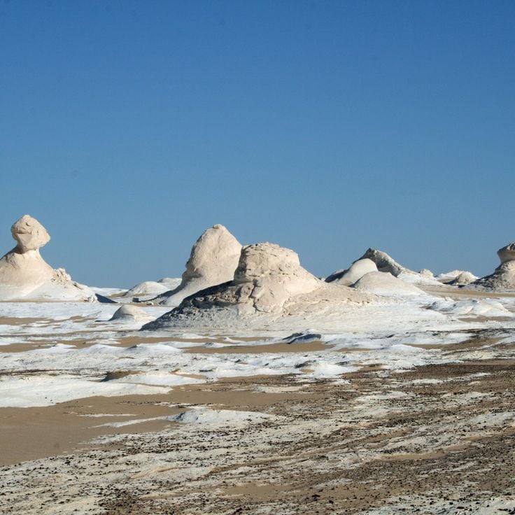
The White Desert covers a landscape of white limestone rock formations shaped by wind erosion over millions of years into structures resembling mushrooms and other forms. This geological formation demonstrates erosion processes where wind and sand abrade the limestone, revealing different levels of rock hardness. The pale formations contrast with the surrounding desert floor and create a concentrated collection of erosional structures. The area documents the long-term effects of wind weathering on sedimentary rock in arid climates.
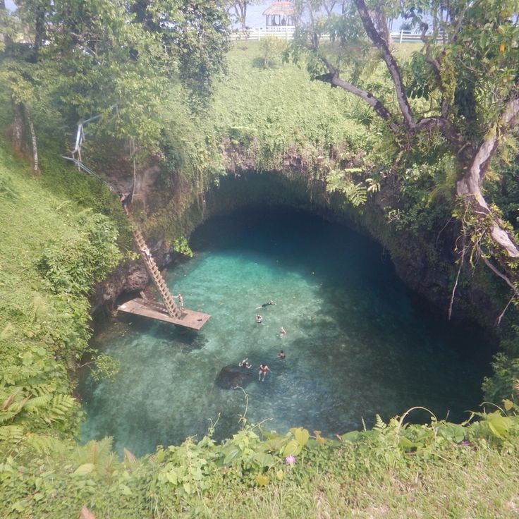
This natural formation developed through volcanic activity and forms a pool approximately 100 feet (30 meters) deep. The To Sua Ocean Trench connects to the Pacific Ocean through underground tunnels. Ocean water flows through these passages into the trench, creating a location where visitors can swim in a sheltered basin while tidal forces from the ocean circulate the water. Volcanic processes shaped this geological structure over extended periods, forming the characteristic lava rock walls.
The Badab-e Surt terraces are natural formations created by mineral deposits from two separate springs with different mineral compositions and water temperatures. The terraces display red and orange hues resulting from iron oxide and other minerals. Water flows over limestone layers, forming these stepped pools. The springs sit at different elevations in the Zagros Mountains and have developed distinct chemical properties. This geological formation took thousands of years to develop through continuous mineral deposition.
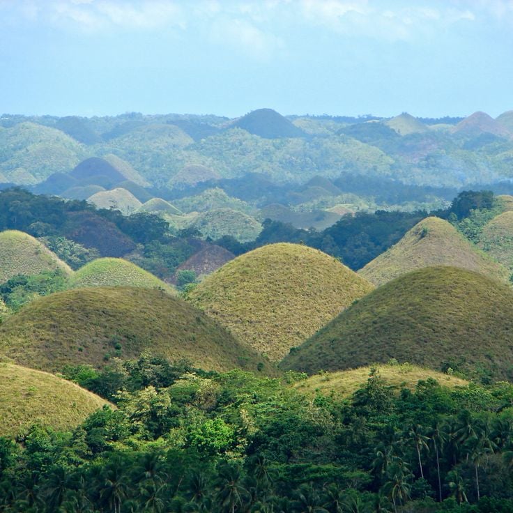
These geological hills in Bohol comprise over 1,200 near-symmetrical limestone cones spread across 19 square miles (50 square kilometers). The formations developed through the uplift of coral reefs and subsequent erosion over millions of years. During the dry season, the vegetation changes color from green to brown, creating the characteristic landscape. The hills rise between 98 and 164 feet (30 and 50 meters) above the plain and form a distinctive geological phenomenon within the Philippine karst landscape.
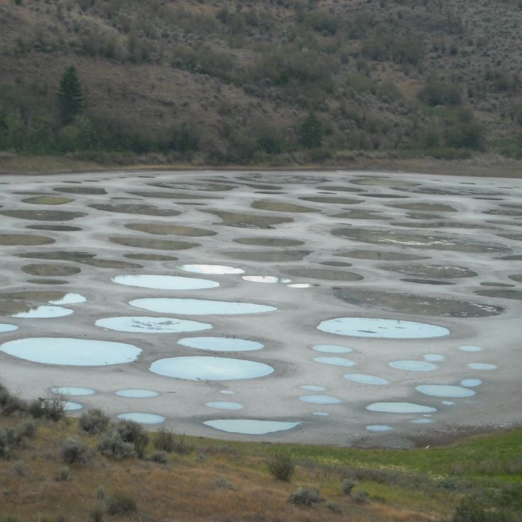
This mineral lake in Osoyoos contains high concentrations of minerals that create circular patterns on its surface during summer evaporation. The lake displays geological processes formed through mineral deposits over extended periods. The patterns change throughout the season as water evaporates and different mineral layers become visible. This lake is part of the geological structures shaped by mineral deposits that demonstrate Earth's diversity.
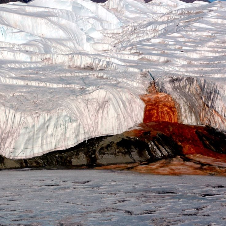
These ice formations at Taylor Glacier result from iron oxide rich salt water flowing from within the glacier and freezing upon contact with air. The high iron oxide content gives the frozen water a red coloration. The outflow occurs periodically and creates distinctive structures on the glacier surface through repeated freezing. The phenomenon documents subglacial water flows and the oxidation of dissolved minerals under extreme conditions.
This sandstone formation in the Vermilion Cliffs displays striking red and orange layers shaped by erosional processes over millions of years. The Wave consists of Jurassic Navajo sandstone with undulating structures created by wind and water erosion. The parallel lines document different depositional periods in what was once a desert landscape. Access is limited to 20 people daily to protect the geological formation. The rock layers contain iron oxide compounds responsible for the characteristic coloring.
This geological formation in Shawnee National Forest displays sandstone structures spanning 1600 acres (647 hectares). The rocks and cliffs of Garden of the Gods formed through millions of years of erosion, creating distinct formations. Hiking trails wind between the sandstone structures, allowing visitors to observe the geological features at close range.
The Subway is a tube-shaped slot canyon with red rock walls and waterfalls in Zion National Park, formed by natural erosion processes. This geological formation demonstrates the transformative power of water over millions of years, carving the Navajo Sandstone into a narrow, winding passage. The canyon walls display complex layering and color variations that reflect different mineral compositions and periods of deposition. Water continues to flow through the formation, contributing to the ongoing shaping of its distinctive geometry.
Thor's Well is a roughly 20-foot-deep (6-meter) depression in basalt rock that draws in seawater during high tide and expels it during low tide. This geological formation on the Pacific coast formed through the erosion of volcanic rock and the continuous action of waves and tides. The opening in the rock creates a natural pumping system where water circulates through the crater. The formation demonstrates the ongoing geological processes that shape coastal landscapes and represents an example of the interaction between volcanic structures and ocean erosion.
Antelope Canyon demonstrates the power of water erosion, which carved narrow, winding passages through red Navajo sandstone walls over millions of years. This geological formation near Page developed through seasonal flash floods that abraded and smoothed the soft sandstone rock. The passages reach depths of approximately 120 feet (37 meters) below the surface, with some corridors measuring only a few feet wide at their narrowest points. Light entering through openings at the surface creates shifting colors and shadows on the undulating rock walls.
Tianmen Mountain is a geological formation in Zhangjiajie, marked by a natural arch located at 4265 feet above sea level. This opening in the limestone massif formed through thousands of years of erosion that carved away softer rock, creating a passage approximately 197 feet high and 187 feet wide. A winding mountain road with 99 switchbacks connects the valley floor to the summit plateau, ascending more than 3280 feet over a distance of 6.8 miles. The steep limestone walls display distinct layering from different geological periods.
This volcanic landscape in central Anatolia displays cone-shaped tuff stone formations created by the erosion of volcanic ash deposits. The soft rock layers allowed people to carve dwellings and churches into the formations for centuries. The underground cities and rock-cut churches of Cappadocia demonstrate the geological malleability of tuff stone, which was deposited millions of years ago through volcanic activity. The characteristic fairy chimneys and valleys formed through differential erosion between harder and softer rock layers.
Mount Thor rises from Baffin Island and presents a vertical granite cliff face that drops over 4100 feet (1250 meters). This geological formation developed through glacial erosion during the last ice age, when glaciers carved away surrounding rock and left the steep cliff behind. The mountain extends across an area of about 40 square miles (105 square kilometers) and demonstrates the result of millions of years of geological processes in Canada's Arctic region.
Hvitserkur is a 15-meter (49-foot) basalt formation on the coast of Vatnsnes shaped by millions of years of erosion. This rock structure rises from the sea and resembles the form of a drinking animal. The base has been reinforced with concrete to prevent further erosion from waves and tides. The geological formation demonstrates volcanic activity and the ongoing effects of marine processes on basalt rock.
These limestone pillars rise from yellow sand in the Nambung Desert and document geological processes that developed over millions of years. The Pinnacles formed through the petrification of tree trunks and subsequent erosion of surrounding sediments. The vertical formations vary in height and shape, with some reaching several yards tall. The area displays thousands of these structures, shaped by calcium deposits and wind. The yellow color of the sand results from iron-bearing minerals. The Pinnacles demonstrate the interaction between organic material, mineral deposits, and erosional forces in this geological structure.
This canyon extends for two miles and reaches a depth of approximately 330 feet (100 meters). Fjadrargljufur formed during the last ice age as glacial meltwater carved through volcanic rock. The steep walls display layers of basalt and palagonite shaped by repeated erosion. The Fjadra River flows at the canyon floor, having cut the winding path through the bedrock over thousands of years. The geological formation documents glacial and fluvial processes that shaped Iceland's landscape during and after the ice age.
These caves house millions of Arachnocampa luminosa, a species of fungus gnat endemic to New Zealand. The larvae of these insects produce bioluminescent blue light on the cave ceilings as they attract prey with glowing silk threads. The cave system formed approximately 30 million years ago through limestone dissolution and erosion. The Waitomo Caves extend across several miles of underground galleries and rivers, with the Glowworm Grotto representing the most concentrated area of these luminescent organisms. The constant cave climate with high humidity allows the larvae to survive during their several-month developmental phase.
Deadvlei is a dried clay basin within Namib-Naukluft National Park, known for its black acacia stumps surrounded by tall red dunes. The basin formed around 900 years ago when the Tsauchab River changed course, leaving the trees to die from lack of water. The intense heat and aridity have preserved the trees without allowing them to decay. The surrounding dunes are among the tallest in the world, reaching heights of over 980 feet (300 meters). The contrast between the dark tree skeletons, white clay floor, and rust-colored dunes makes this geological formation a distinctive example of desert processes.
This glacier extends for 19 miles (30 kilometers) with a 3-mile (5-kilometer) wide front that advances from the Southern Patagonian Ice Field. The formation demonstrates active glacial processes where large ice pieces regularly calve from the terminal face into Lago Argentino. Perito Moreno Glacier represents one of the few glaciers worldwide maintaining an equilibrium state where ice accumulation balances melting processes. The ice mass reaches heights up to 240 feet (74 meters) above water level and documents geological climate processes spanning millennia.
Neist Point is the westernmost cape of the Isle of Skye and displays geological layering of volcanic rock formed during the Tertiary period. The cliffs rise 328 feet (100 meters) above the sea and reveal basalt formations shaped by erosion and tectonic processes. A lighthouse built in 1909 stands at the end of the rocky peninsula, where the geological structures face marine weathering processes. The rock formations document volcanic activity that shaped this region millions of years ago and contributed to the formation of the distinctive coastal geology.
This national park comprises a system of 16 terraced lakes connected by waterfalls and underground karst rivers. Plitvice Lakes formed through calcium carbonate deposits over thousands of years, creating natural travertine barriers that separate individual basins. The geological system demonstrates the interaction between water, rock, and organic processes. The lakes sit at different elevations between the upper and lower sections of the park, with water flowing continuously from one basin to the next through a series of cascades and subterranean channels.
These natural tunnels form when meltwater flows through the glacier ice of Vatnajokull. The walls display various shades of blue and ice patterns shaped by the pressure and compaction of snow over centuries. Vatnajokull covers an area of approximately 3,100 square miles (8,100 square kilometers), making it the largest glacier in Europe. The ice caves are temporary geological formations that reform and change each year as meltwater streams carve new paths through the ice.
These marble caves consist of limestone formations shaped over a period of 6,000 years by the waters of Lake General Carrera. The geological structures demonstrate the result of continuous water erosion, where waves and currents gradually wore away the soft carbonate rock. The caves display smooth, undulating surfaces created by the mechanical action of the lake water. The turquoise water of the lake reflects against the cave walls, creating shifting color patterns. The formation sits at the edge of one of South America's largest lakes and is accessible only by boat.
This geological formation in the Zhangye Danxia National Park displays layered red sandstone colored by iron oxides, along with yellow, orange and green stripes created by various mineral deposits. The multicolored rock layers formed over 24 million years through the deposition of sandstone and siltstone, followed by tectonic uplift and erosion. The landform covers approximately 193 square miles (500 square kilometers) and reaches heights of up to 1600 feet (490 meters) above the valley floor. The different colors result from oxidized iron and other minerals deposited under varying climatic conditions.
This canyon extends 277 miles (446 kilometers) through Arizona and reveals rock layers cut by a river over millions of years. The gorge reaches depths exceeding 6,000 feet (1,800 meters) and exposes a geological record spanning nearly two billion years. The different sedimentary strata display distinct epochs of Earth's history, from Precambrian formations to more recent deposits. The Colorado River shaped this geological structure through continuous erosion, creating one of the most significant exposures of tectonic and sedimentary processes in North America.
These thermal springs formed through mineral-rich water flowing down the mountain slope over thousands of years, creating the distinctive white limestone formations of Pamukkale. The water carries calcium carbonate from underground sources to the surface, where it crystallizes upon cooling and forms the terraced pools and travertine deposits. The geological processes that created this formation remain active today, continuously adding new layers to the existing limestone structure. The springs reach temperatures of approximately 95 degrees Fahrenheit (35 degrees Celsius) and have attracted people since ancient times.
The Giant's Causeway consists of approximately 40,000 hexagonal basalt columns formed 60 million years ago through intense volcanic activity. This coastal geological structure in County Antrim displays the processes of solidified lava flows, where molten rock cooled and fractured into distinctive prismatic shapes. The columns reach heights of up to 39 feet (12 meters) and extend from the cliff face into the sea, where they become visible at low tide.
This saltwater lake on Middle Island displays pink coloration caused by the algae species Dunaliella salina and high salinity levels. Lake Hillier extends approximately 2,000 feet (600 meters) in length within the Recherche Archipelago. The pink hue remains even when water is removed from the lake. The geological formation resulted from marine processes and mineral deposition over extended periods. A narrow strip of sand separates the lake from the Southern Ocean, while dense vegetation surrounds its perimeter. The coloration demonstrates the interaction between microorganisms and extreme environmental conditions in this natural formation.
This stone forest area contains more than 3000 narrow sandstone pillars and peaks in Hunan Province, some rising over 650 feet (200 meters) high. The formations developed through physical erosion processes over millions of years. The geological structure displays various stages of weathering and removal of sandstone layers. The area demonstrates the diversity of Earth processes shaped by water and wind action.
This geothermal geyser is an accidental geological structure created in 1964 through drilling attempts. Fly Geyser continuously releases mineral-rich water at approximately 200°F (93°C) from several openings. The expelled minerals formed terraced calcium carbonate deposits over decades, colored red, green, and orange by thermophilic algae. The formation reaches approximately 5 feet (1.5 meters) in height and continues growing through ongoing mineral deposition that shapes characteristic cones.
This 180-million-year-old limestone cave extends 787 feet (240 meters) underground. Reed Flute Cave displays stalactites, stalagmites, and other geological formations created through erosion and mineral deposits. Colored LED lighting highlights the natural structures within the cave, revealing the various rock layers that formed over geological time periods. The cave system demonstrates the ongoing processes of carbonate dissolution and precipitation that shape such subterranean environments.
This coastal marsh in Panjin spans 2,400 acres (970 hectares) and turns red each autumn when Suaeda salsa, a salt-tolerant plant, develops its characteristic red coloration. The wetland formed through sediment deposits from the Liaohe River and provides habitat for numerous waterbirds. The geological formation demonstrates the interaction between river dynamics and tidal influence, where salt concentration in the soil enables growth of specialized vegetation. The area exhibits geological processes of coastal morphology and sediment formation.
This crater formed in 1971 when Soviet geologists ignited an underground cavern of natural gas to prevent methane spread. The Door to Hell measures 230 feet (70 meters) wide and has burned continuously for over five decades. The fire within the crater is fueled by the ongoing release of natural gas from the reservoir below. This geological formation demonstrates the consequences of human intervention in natural gas deposits and shows the longevity of burning natural gas sources in the Karakum Desert.
This grotto consists of two connected caves extending over six kilometers, formed through limestone dissolution. Underground rivers have created stalagmites, stalactites, and other mineral formations over thousands of years. The upper cave is accessible by foot, while the lower features an active waterway navigable by boat. The system demonstrates geological processes of carbonate formation and mineral deposition typical of the region.
The White Desert covers a landscape of white limestone rock formations shaped by wind erosion over millions of years into structures resembling mushrooms and other forms. This geological formation demonstrates erosion processes where wind and sand abrade the limestone, revealing different levels of rock hardness. The pale formations contrast with the surrounding desert floor and create a concentrated collection of erosional structures. The area documents the long-term effects of wind weathering on sedimentary rock in arid climates.
This natural formation developed through volcanic activity and forms a pool approximately 100 feet (30 meters) deep. The To Sua Ocean Trench connects to the Pacific Ocean through underground tunnels. Ocean water flows through these passages into the trench, creating a location where visitors can swim in a sheltered basin while tidal forces from the ocean circulate the water. Volcanic processes shaped this geological structure over extended periods, forming the characteristic lava rock walls.
The Badab-e Surt terraces are natural formations created by mineral deposits from two separate springs with different mineral compositions and water temperatures. The terraces display red and orange hues resulting from iron oxide and other minerals. Water flows over limestone layers, forming these stepped pools. The springs sit at different elevations in the Zagros Mountains and have developed distinct chemical properties. This geological formation took thousands of years to develop through continuous mineral deposition.
These geological hills in Bohol comprise over 1,200 near-symmetrical limestone cones spread across 19 square miles (50 square kilometers). The formations developed through the uplift of coral reefs and subsequent erosion over millions of years. During the dry season, the vegetation changes color from green to brown, creating the characteristic landscape. The hills rise between 98 and 164 feet (30 and 50 meters) above the plain and form a distinctive geological phenomenon within the Philippine karst landscape.
This mineral lake in Osoyoos contains high concentrations of minerals that create circular patterns on its surface during summer evaporation. The lake displays geological processes formed through mineral deposits over extended periods. The patterns change throughout the season as water evaporates and different mineral layers become visible. This lake is part of the geological structures shaped by mineral deposits that demonstrate Earth's diversity.
These ice formations at Taylor Glacier result from iron oxide rich salt water flowing from within the glacier and freezing upon contact with air. The high iron oxide content gives the frozen water a red coloration. The outflow occurs periodically and creates distinctive structures on the glacier surface through repeated freezing. The phenomenon documents subglacial water flows and the oxidation of dissolved minerals under extreme conditions.