See the monuments around you in AROpen chests in the app
Around Us is built for your phone — point your camera at the streets and discover the monuments and places around you in augmented reality.Around Us is built for your phone — chests unlock when you walk, explore and capture nearby places.
Ethiopia offers photographers a range of subjects from medieval architecture to geologically active zones. In the north, Lalibela features eleven churches carved from solid tuff rock during the 12th and 13th centuries, while Axum holds obelisks from the Aksumite Empire that flourished from the 1st to 10th centuries. The Gheralta region of Tigray contains dozens of churches built into cliff faces, accessible via steep trails.The landscape extends from the peaks of the Simien Mountains, rising above 15,000 feet (4,500 meters), to the Danakil Depression, one of the lowest and hottest places on Earth. Bale Mountains National Park supports Ethiopian wolves in afroalpine moorlands, while Awash National Park features acacia woodlands and hot springs. The walled city of Harar Jugol, with its 368 lanes and 82 mosques dating from the 16th century, displays Islamic architecture. The monasteries on Lake Tana islands hold manuscripts from the 14th to 18th centuries, and in Gondar, Fasil Ghebbi documents Ethiopian rule through its 17th and 18th century palaces and churches.
Ethiopia offers photographers a range of subjects from medieval architecture to geologically active zones. In the north, Lalibela features eleven churches carved from solid tuff rock during the 12th and 13th centuries, while Axum holds obelisks from the Aksumite Empire that flourished from the 1st to 10th centuries. The Gheralta region of Tigray contains dozens of churches built into cliff faces, accessible via steep trails.The landscape extends from the peaks of the Simien Mountains, rising above 15,000 feet (4,500 meters), to the Danakil Depression, one of the lowest and hottest places on Earth. Bale Mountains National Park supports Ethiopian wolves in afroalpine moorlands, while Awash National Park features acacia woodlands and hot springs. The walled city of Harar Jugol, with its 368 lanes and 82 mosques dating from the 16th century, displays Islamic architecture. The monasteries on Lake Tana islands hold manuscripts from the 14th to 18th centuries, and in Gondar, Fasil Ghebbi documents Ethiopian rule through its 17th and 18th century palaces and churches.
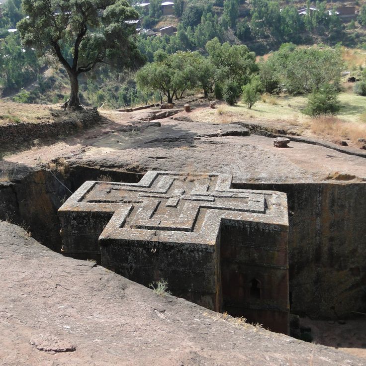
This religious site contains eleven churches carved from volcanic rock in the 12th century, representing examples of medieval architecture in Ethiopia. Lalibela documents the technical achievement of Ethiopian stonemasons who shaped each church as a monolithic structure from the bedrock, creating a reference point for medieval ecclesiastical construction in the region.
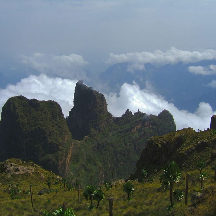
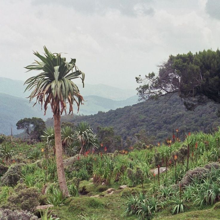
This national park presents high mountain landscapes with peaks exceeding 14,800 feet (4500 meters), including Ras Dashen, Ethiopia's highest mountain. The geology features eroded volcanic plateaus, deep valleys and vertical escarpments. The park hosts Ethiopian ibex, Gelada baboons and various raptors, including the lammergeier. Hiking routes traverse Afroalpine vegetation zones between 6,200 and 14,800 feet (1900 and 4500 meters).
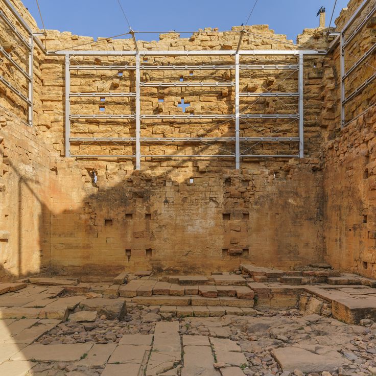
This historic city presents granite monuments from the 4th century spread across an area of roughly 5 square miles (8 square kilometers). The site includes multiple stelae, with the tallest standing example reaching 79 feet (24 meters), along with remains of palaces and tombs from the ancient kingdom of Aksum. The monoliths were carved from single blocks of stone without mortar, displaying ornamental details representing multi-story buildings. Archaeological excavations have revealed underground chambers and foundations that provide insights into early Christian construction methods in the region.
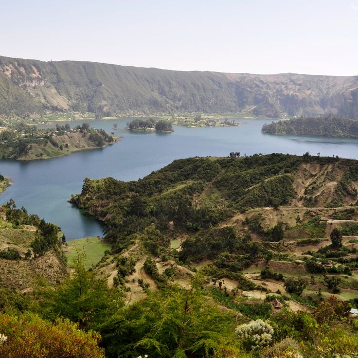
These monasteries on the islands of Lake Tana preserve 14th-century Orthodox architecture along with traditional wall paintings and historical texts that document Ethiopia's religious heritage and rank among the region's most significant photography subjects.
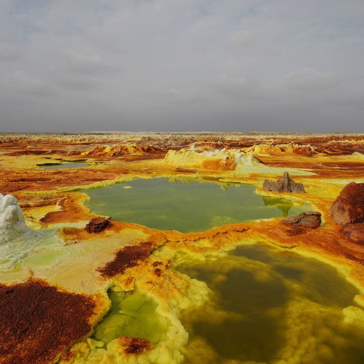
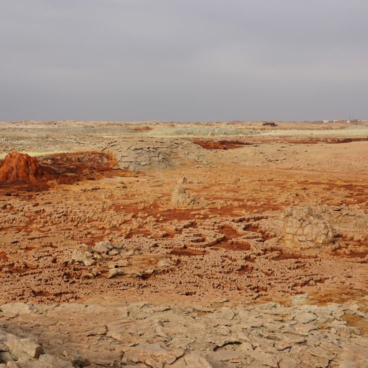
The Danakil Depression sits in the Afar region and forms a tectonic basin with mineral springs in various colors, yellow sulfur fields and white salt crusts. This area extends across volcanic terrain approximately 400 feet (120 meters) below sea level and displays geological processes resulting from plate tectonic activity. The formation represents one of the lowest land points in Africa and presents sulfur deposits, salt flats and hydrothermal springs that offer photographers unusual colors and textures.
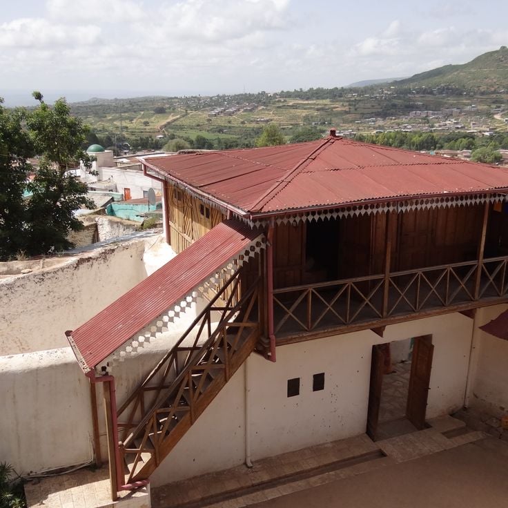
This walled city dating from the 13th century contains 82 mosques and 102 shrines within its historic fortifications. The narrow streets of Harar Jugol connect traditional markets with religious sites that document centuries of Islamic history in East Africa. The city serves as an important reference point for Ethiopia's architectural and cultural diversity within this collection of photography locations.
Bale Mountains National Park extends across a highland region with peaks reaching up to 14,418 feet (4,395 meters). The Sanetti Plateau holds the largest population of Ethiopian wolves, while afroalpine vegetation zones, glacial lakes and rock formations define the landscape. Valleys with heather moorlands and giant lobelias lead to mountain streams flowing through volcanic rock. The park covers several climate zones from 4,900 to over 13,000 feet (1,500 to over 4,000 meters) and serves as a watershed for the region.
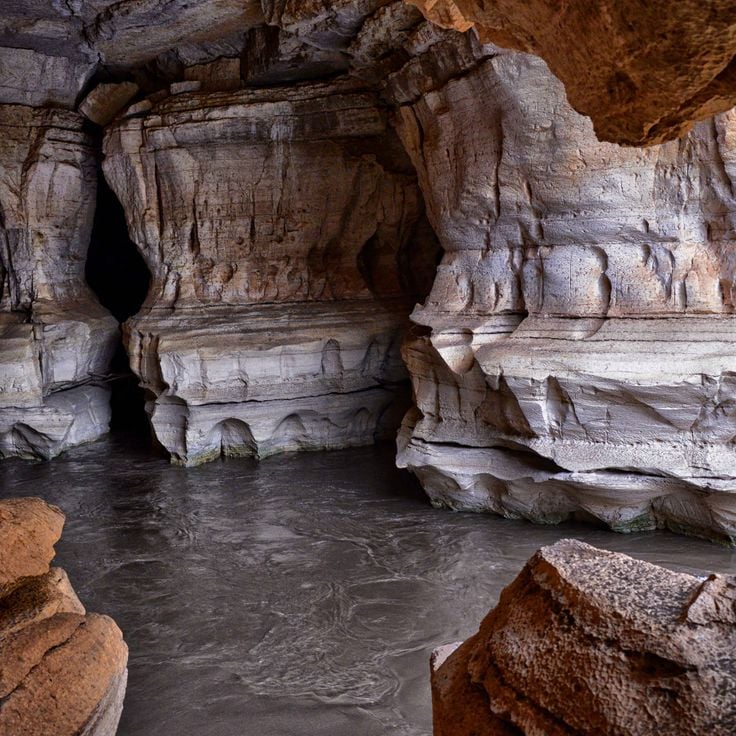
This limestone cave system extends for roughly 15 kilometers (about 9 miles) and displays underground rivers along with natural columns. Sof Omar Caves complements Ethiopia's geological diversity with formations shaped by water erosion over thousands of years, offering visitors insight into the region's subterranean landscape and contributing to the country's natural heritage alongside volcanic areas and national parks.
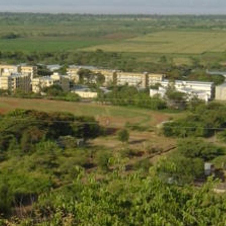
This capital city houses the National Museum with paleoanthropological collections, the expansive Merkato Market and the university campus. Addis Ababa serves as headquarters of the African Union and functions as the administrative and cultural center of the country that encompasses medieval churches, mountain landscapes and historical sites across its regions.
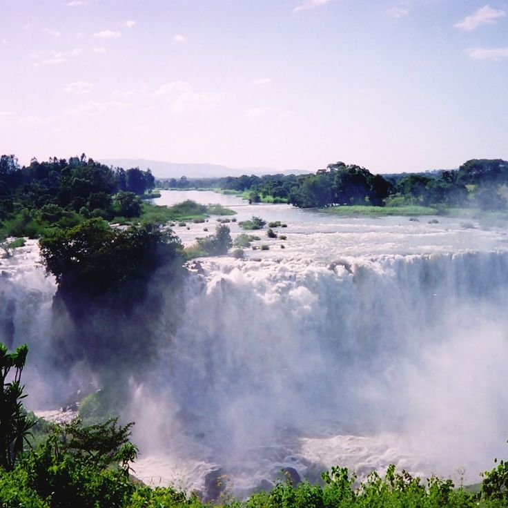
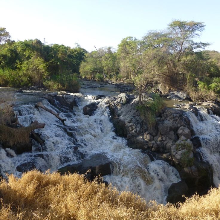
The Blue Nile Falls drop 45 meters (150 feet) and form one of the main water sources of the Nile River. Local people call the waterfall Tis Issat, meaning smoking river. The waters of the Abay River thunder over basalt cliffs and create a fine mist that forms rainbows in sunlight. The falls lie approximately 19 miles (30 kilometers) south of Bahir Dar in the Amhara Region and are part of the Ethiopian highland landscape. A footpath leads to several viewpoints along the gorge. Water volume varies by season and reaches its peak during the rainy period between June and September.
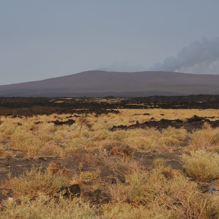
This volcano in the Danakil region contains one of the few permanent lava lakes on Earth, sitting at an elevation of 2011 feet (613 meters). Erta Ale maintains continuous volcanic activity with visible magma movement in the crater. The geological conditions provide photographers with opportunities to document molten lava and volcanic formations in one of Ethiopia's most geologically active zones.
This 17th-century church displays wall paintings with religious motifs and 104 winged angel faces on the ceiling. Debre Berhan Selassie stands in Gondar, a city known for its ecclesiastical buildings and fortifications. The site complements the medieval churches of Lalibela, ancient obelisks of Axum and lake monasteries on Tana islands as part of Ethiopia's religious and architectural photography subjects.
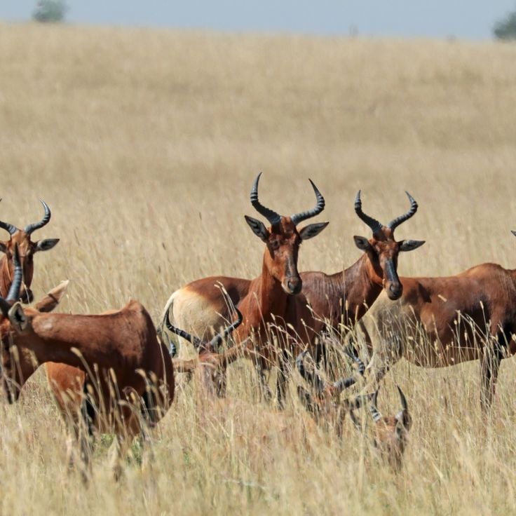
This national park covers 756 square kilometers (292 square miles) of savanna with antelopes, gazelles, lions and 450 bird species along the Awash riverbank, complementing Ethiopia's natural diversity through its wildlife and geological formations in the Afar region.
Southern Nations, Nationalities, and Peoples' Region, Ethiopia
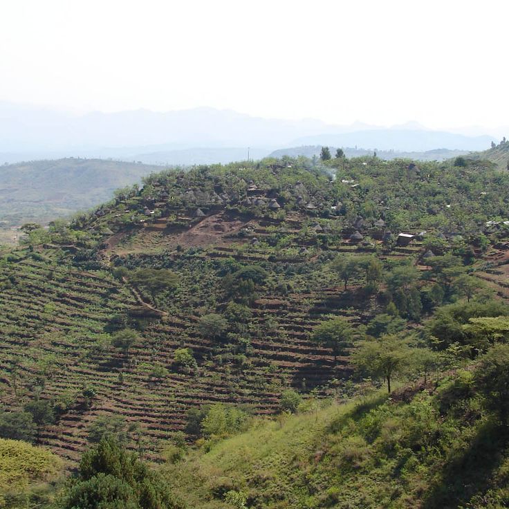
This cultural landscape displays the terraced fields and stone walls the Konso people built over generations across the hills of southern Ethiopia. The hilltop villages contain wooden grave statues and ritual poles that honor their ancestors. The dry stone walls stabilize the slopes for growing sorghum and other crops. The settlements cluster around central squares where ceremonial stones mark the social order of the community. This UNESCO site documents a sustainable land use system adapted to the topography and climate of this region.
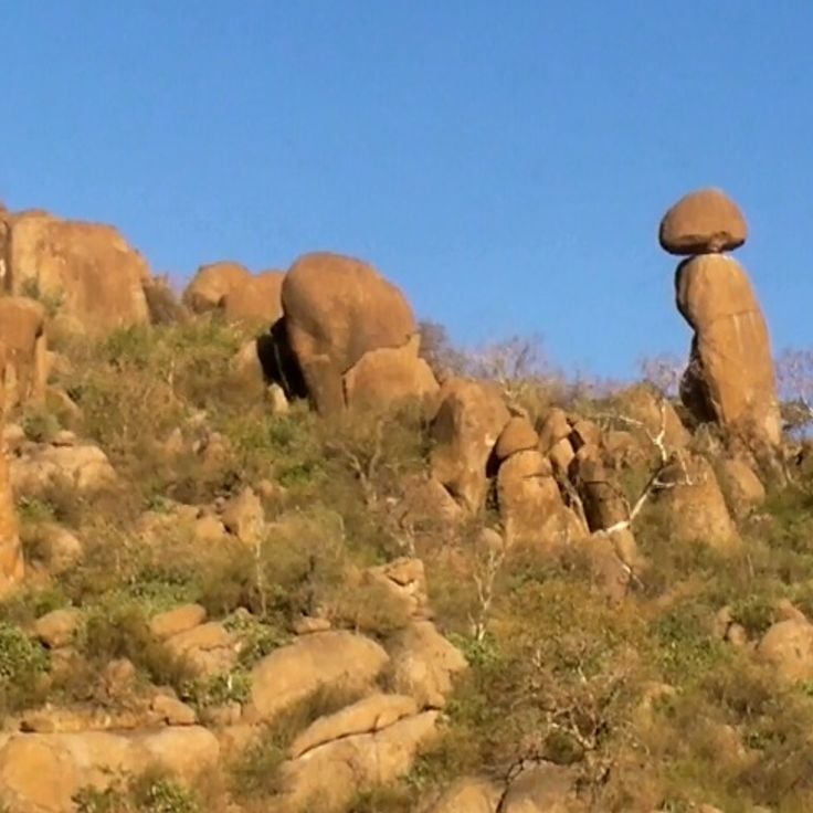
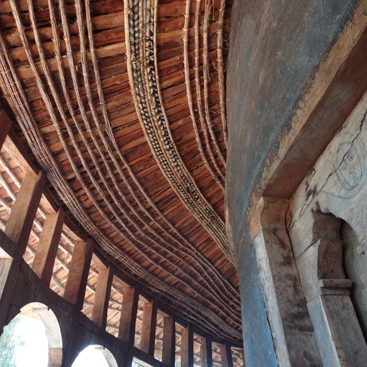
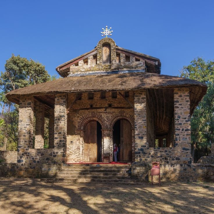
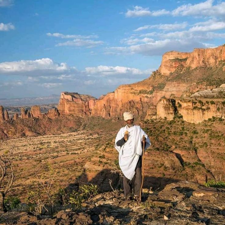
This mountain region in Tigray contains 30 orthodox rock churches from the sixth century carved into sandstone cliffs, featuring murals and religious artifacts spanning several centuries. Gheralta ranks among Ethiopia's major sites of orthodox architecture alongside the churches of Lalibela and the monasteries of Lake Tana, offering views across the surrounding highlands with steep table mountains and agricultural valleys.
Southern Nations, Nationalities, and Peoples' Region, Ethiopia
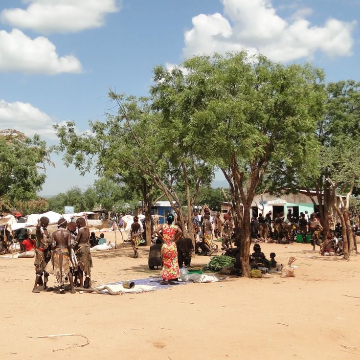
The Omo Valley hosts eight ethnic groups maintaining distinct languages, cultural practices and traditional dress along the Omo River corridor. This southern Ethiopian region provides insight into traditional ways of life, body decoration and ceremonial practices that continue across scattered settlements, offering documentary subjects for photographers interested in anthropological diversity and cultural traditions preserved in remote communities.
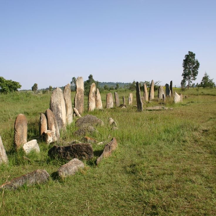
Tiya presents 36 decorated stone pillars from the 12th century that served as grave markers and form part of Ethiopia's cultural heritage. This archaeological site documents the historical burial practices of the region, complementing the medieval churches of Lalibela and ancient obelisks of Axum. The stelae display geometric and figurative motifs that provide insights into the prehistoric traditions of the area.
Dallol sits in the Danakil Depression and ranks among the hottest inhabited places on Earth, with average temperatures exceeding 93°F (34°C). The volcanic landscape displays yellow and orange sulfur springs, salt formations and mineral deposits created by geothermal activity. This site contrasts with the highland churches of Lalibela and the mountains of Simien National Park, adding to Ethiopia's geological diversity through its extreme climatic conditions and active hydrothermal fields.
Jinka serves as the commercial center for the Mursi and Ari peoples in the southern Ethiopian lowlands. The Museum of Southern Peoples displays ethnographic collections from the region, including clay vessels, cattle shields and ornaments made from metal and beads. The weekly market brings traders from surrounding villages who sell spices, basketwork and textiles. This town functions as a base for trips to villages in the Omo Valley, where traditional ways of life can be documented.
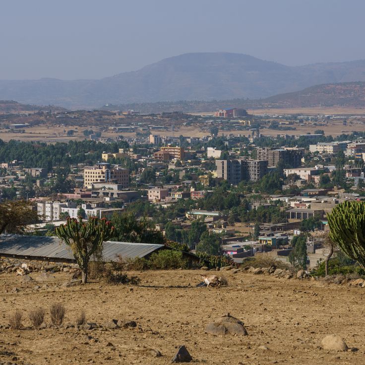
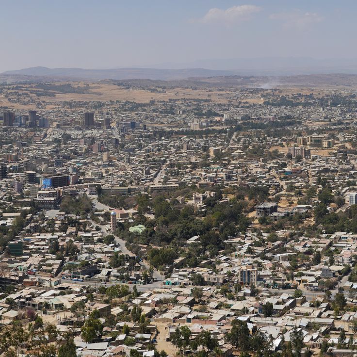
Mekele serves as the administrative center of the Tigray Region and sits at the southern gateway to the Simien Mountains. The Palace of Emperor Yohannes IV from the 19th century stands in the city center and displays the imperial architecture of Ethiopia from that era. The Regional History Museum preserves artifacts and documents related to Tigray history. This city forms a starting point for visits to the nearby rock churches and the Danakil region with its geological formations.
This national park extends along Lake Chamo and includes savanna and forested areas where zebras live in large numbers. The lake forms a natural boundary between different habitats. Nechisar complements the photographic range of Ethiopia, from geological formations to historic sites, with landscapes that combine wildlife and water margins for diverse shooting opportunities throughout the park.
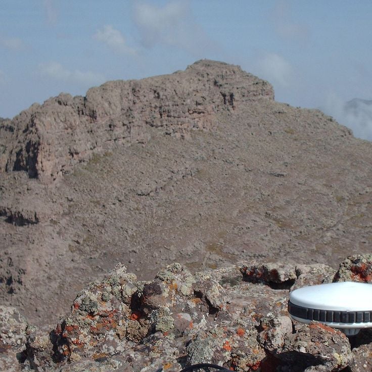
This summit reaches an elevation of 14,928 feet (4,550 meters) in the Simien Mountains and forms Ethiopia's highest massif. Ras Dashen provides a vantage point over the surrounding mountain range, which features rock formations shaped by erosion and deep valleys. The route to the summit passes through different vegetation zones, from highland grasslands to barren alpine areas. Photographers find subjects here with geological structures and changing light conditions across times of day and seasons. The ascent requires several days and acclimatization due to the altitude.
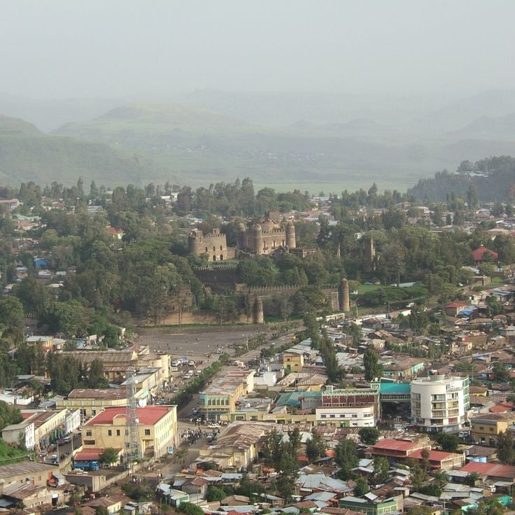
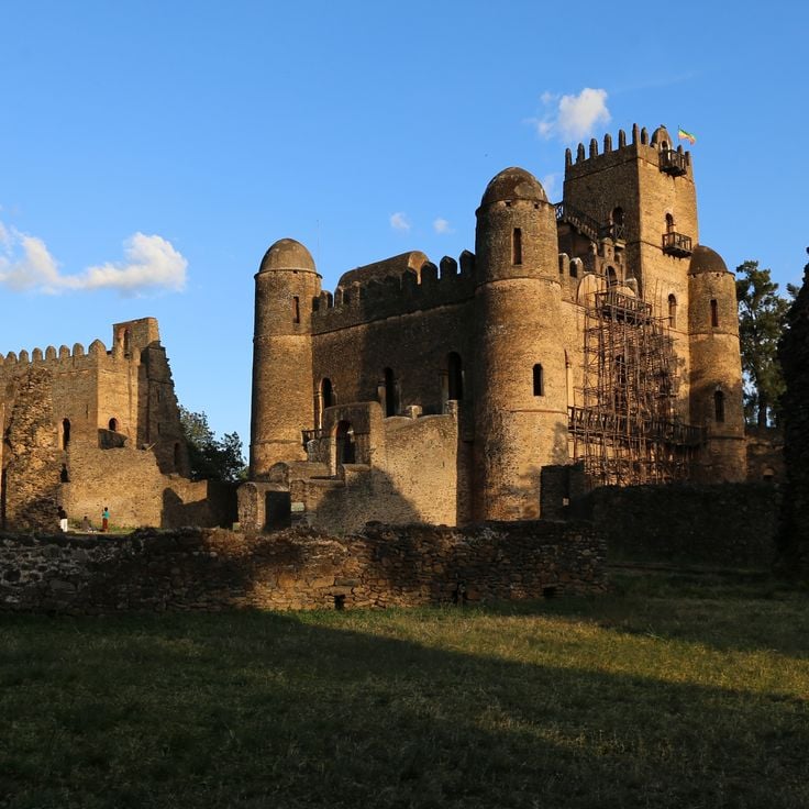
This historic site in Gondar displays the remains of Ethiopian imperial architecture from the 17th century, with multiple stone towers, palaces and fortified walls within the Royal Enclosure that serve as photographic documentation of the country's medieval building traditions.
Arba Minch sits between Lakes Abaya and Chamo in southern Ethiopia and serves as a base for photographers documenting the lake landscapes and surrounding national parks. The name means forty springs in the Amharic language and refers to the numerous natural water sources in the region. This city offers perspectives on both lakes as well as the Nech Sar Mountains to the east, which shelter various wildlife species.
This lake allows photographing water birds, traditional fishing boats and shoreline vegetation with acacia and fig trees, showcasing Hawassa's importance for migratory bird routes and local fishing communities and complementing Ethiopia's natural elements that include the medieval churches of Lalibela, the mountain ranges of Simien National Park and the ancient obelisks of Axum.
Chebera Churchura National Park offers varied terrain for wildlife photography in savannas and forests where elephants, antelopes and numerous bird species live. This landscape in the southern highlands presents an important protected area for large mammals and expands Ethiopia's photographic range beyond the medieval churches of Lalibela and ancient obelisks of Axum to include natural subjects in their native habitat.
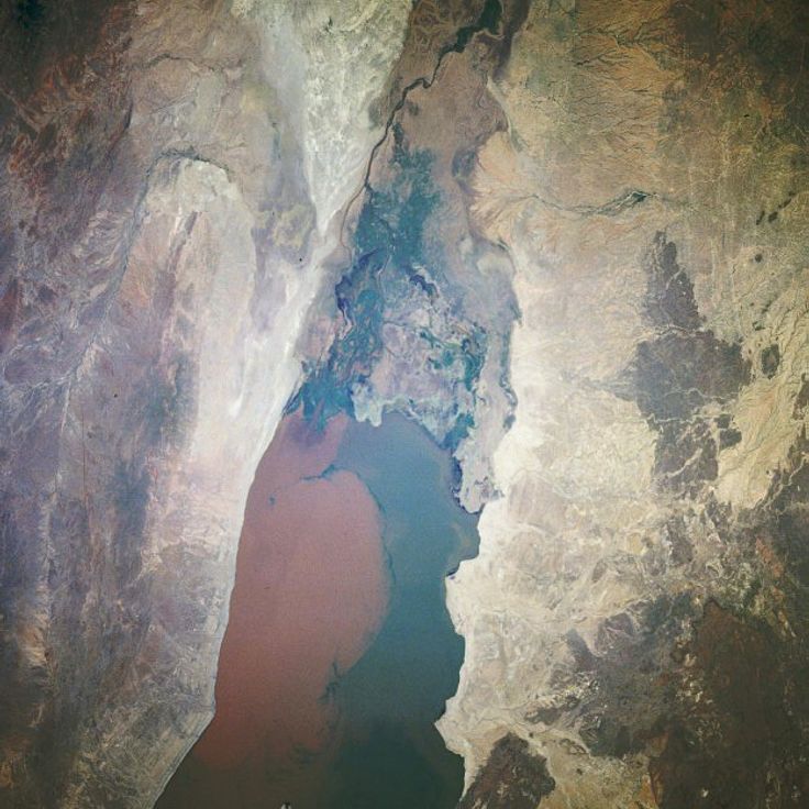
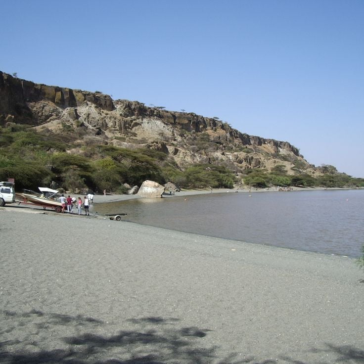
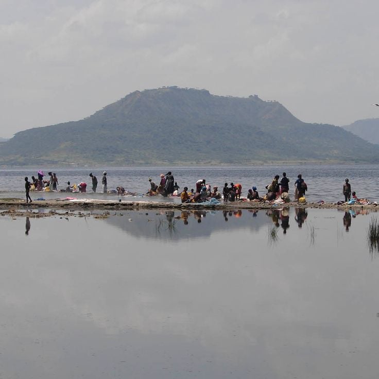
This lake in the East African Rift attracts photographers with its brown-tinted waters and sandy shores. The unusual coloration comes from volcanic minerals in the surrounding highlands. Sunrise and sunset shots reveal the contrasts between the dark water, pale beaches and changing skies over the Ethiopian landscape.
Wenchi Crater Lake sits in an extinct volcanic caldera in the Ethiopian highlands at roughly 10,000 feet (3,000 meters) elevation. Thermal springs emerge along several sections of the shoreline, while the surrounding slopes support barley and teff cultivation. A forested island rises from the center of the lake, accessible by boat, and contains a monastery that visitors can reach on foot.
Fasil Ghebbi, the 17th-century royal compound in Gondar, contains stone palaces, imperial baths and Ethiopian Orthodox churches. This residence of the rulers of the Solomonic Empire displays medieval architectural elements in the fortress walls, towers and halls of the various palaces, built over two centuries and representing the historic capital of Ethiopia as a photography location.
This orthodox monastery sits on a mountain above Lalibela and preserves manuscripts and wall paintings from the 13th century. Asheton Maryam contributes to the religious landscape of the region, where medieval churches form a central element. The climb to the monastery follows steep terrain and provides perspectives across the surrounding highlands. The site serves as a pilgrimage destination and houses monks who follow traditional monastic practices.
This nature reserve covers 2,496 square miles of savanna landscape in southern Ethiopia. Yabelo Wildlife Sanctuary serves as habitat for the white-tailed swallow, a bird species found only in this region. The acacia trees and open grasslands support populations of Grevy's zebras, ostriches and several antelope species typical of East African savanna vegetation.
The Senkele Swayne's Hartebeest Sanctuary protects 54 square kilometers (21 square miles) of open grassland in Oromia, established to conserve the critically endangered Swayne's hartebeest. Alongside these rare antelopes, the sanctuary supports populations of oribi, bohor reedbuck and various bird species. The flat terrain with scattered acacia trees provides good conditions for wildlife observation during early morning and late afternoon hours.
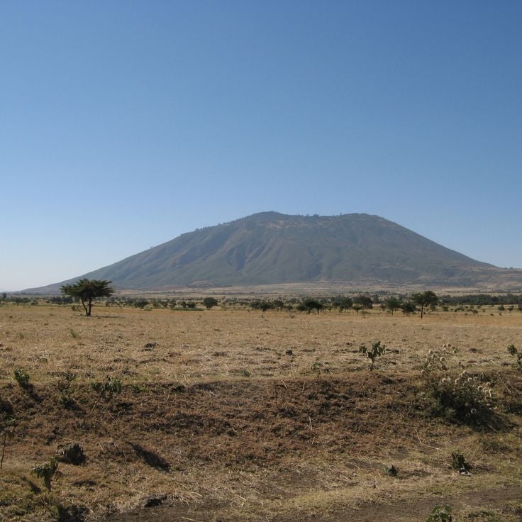
This volcano rises to 9,810 feet (2,989 meters) and contains a crater lake accessible via several mountain trails. Mount Zuqualla adds to Ethiopia's geological range alongside the volcanic formations of Danakil, the mountain ranges of Simien and Bale, and the medieval architecture of Lalibela that characterize this collection of photography locations across the country.
Wondo Genet features geothermal springs with temperatures reaching 149 degrees Fahrenheit (65 degrees Celsius). The facility sits in a region with coffee plantations and a forest research institute. These hot springs form part of the volcanic activity along the East African Rift and offer insight into the geological diversity of Ethiopia, spanning from the medieval churches of Lalibela to the volcanic areas of the Danakil region.
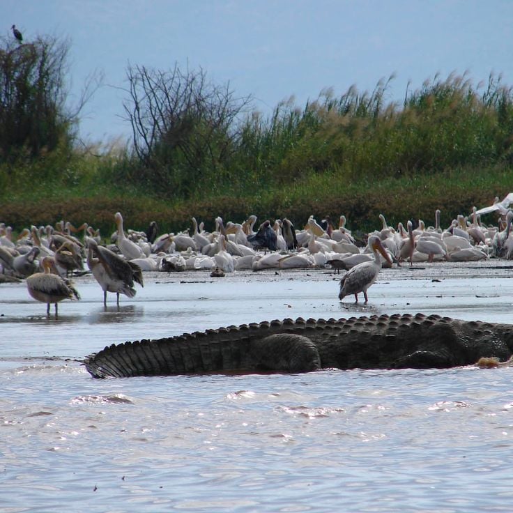
Lake Ziway hosts Orthodox monasteries on five islands and attracts 400 different bird species to its waters. This lake and island landscape sits within the Ethiopian Rift Valley region and provides photographers with religious architecture as well as waterfowl, including pelicans and African darters, gathering against the backdrop of the central highlands.
Southern Nations, Nationalities, and Peoples' Region, Ethiopia
Turmi is a trading center for the Hamer community in the Southern Nations Region. This town hosts regular market days where local communities exchange goods and sell everyday items. Visitors can observe the traditional lifestyle of the Hamer people and occasionally attend cultural ceremonies that offer insight into local customs, making Turmi a significant point among Ethiopia's photography locations.
This ancient temple in Tigray rises to 40 feet (12 meters) with stone walls constructed during the 7th century BCE. The structure provides a photographic record of early Sabean architecture in Ethiopia and demonstrates monumental building techniques from a period long before the medieval churches of Lalibela or the obelisks of Axum that also form part of the country's cultural elements.
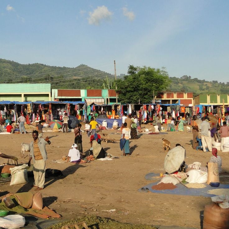
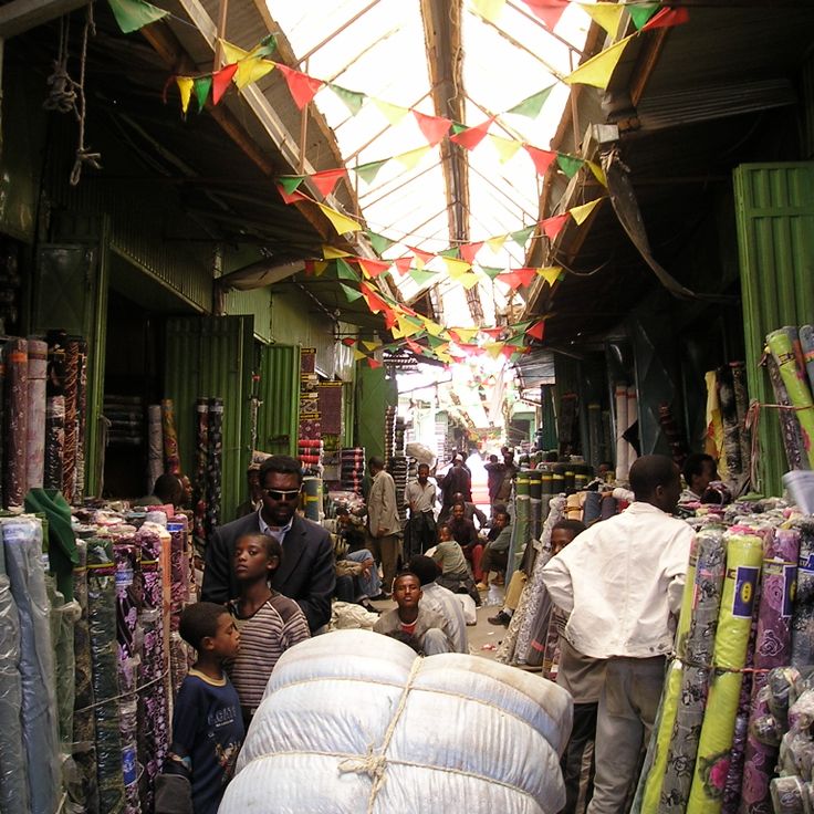
This trading space extends across several square kilometers with stalls selling spices, textiles, crafts and regional products from across Ethiopia. The selling areas are organized by product category and show the commercial life of the capital. Addis Mercato complements the photographic subjects of medieval churches in Lalibela and ancient obelisks in Axum with authentic urban trading scenes.
The Babile Elephant Sanctuary spans 6,982 square kilometers and provides habitat for approximately 400 African elephants in the Oromia region. This sanctuary protects the elephant population and offers photographers opportunities to document these animals in their natural environment as part of Ethiopia's natural diversity.
This religious site contains eleven churches carved from volcanic rock in the 12th century, representing examples of medieval architecture in Ethiopia. Lalibela documents the technical achievement of Ethiopian stonemasons who shaped each church as a monolithic structure from the bedrock, creating a reference point for medieval ecclesiastical construction in the region.
This national park presents high mountain landscapes with peaks exceeding 14,800 feet (4500 meters), including Ras Dashen, Ethiopia's highest mountain. The geology features eroded volcanic plateaus, deep valleys and vertical escarpments. The park hosts Ethiopian ibex, Gelada baboons and various raptors, including the lammergeier. Hiking routes traverse Afroalpine vegetation zones between 6,200 and 14,800 feet (1900 and 4500 meters).
This historic city presents granite monuments from the 4th century spread across an area of roughly 5 square miles (8 square kilometers). The site includes multiple stelae, with the tallest standing example reaching 79 feet (24 meters), along with remains of palaces and tombs from the ancient kingdom of Aksum. The monoliths were carved from single blocks of stone without mortar, displaying ornamental details representing multi-story buildings. Archaeological excavations have revealed underground chambers and foundations that provide insights into early Christian construction methods in the region.
These monasteries on the islands of Lake Tana preserve 14th-century Orthodox architecture along with traditional wall paintings and historical texts that document Ethiopia's religious heritage and rank among the region's most significant photography subjects.
The Danakil Depression sits in the Afar region and forms a tectonic basin with mineral springs in various colors, yellow sulfur fields and white salt crusts. This area extends across volcanic terrain approximately 400 feet (120 meters) below sea level and displays geological processes resulting from plate tectonic activity. The formation represents one of the lowest land points in Africa and presents sulfur deposits, salt flats and hydrothermal springs that offer photographers unusual colors and textures.
This walled city dating from the 13th century contains 82 mosques and 102 shrines within its historic fortifications. The narrow streets of Harar Jugol connect traditional markets with religious sites that document centuries of Islamic history in East Africa. The city serves as an important reference point for Ethiopia's architectural and cultural diversity within this collection of photography locations.
Bale Mountains National Park extends across a highland region with peaks reaching up to 14,418 feet (4,395 meters). The Sanetti Plateau holds the largest population of Ethiopian wolves, while afroalpine vegetation zones, glacial lakes and rock formations define the landscape. Valleys with heather moorlands and giant lobelias lead to mountain streams flowing through volcanic rock. The park covers several climate zones from 4,900 to over 13,000 feet (1,500 to over 4,000 meters) and serves as a watershed for the region.
This limestone cave system extends for roughly 15 kilometers (about 9 miles) and displays underground rivers along with natural columns. Sof Omar Caves complements Ethiopia's geological diversity with formations shaped by water erosion over thousands of years, offering visitors insight into the region's subterranean landscape and contributing to the country's natural heritage alongside volcanic areas and national parks.
This capital city houses the National Museum with paleoanthropological collections, the expansive Merkato Market and the university campus. Addis Ababa serves as headquarters of the African Union and functions as the administrative and cultural center of the country that encompasses medieval churches, mountain landscapes and historical sites across its regions.
The Blue Nile Falls drop 45 meters (150 feet) and form one of the main water sources of the Nile River. Local people call the waterfall Tis Issat, meaning smoking river. The waters of the Abay River thunder over basalt cliffs and create a fine mist that forms rainbows in sunlight. The falls lie approximately 19 miles (30 kilometers) south of Bahir Dar in the Amhara Region and are part of the Ethiopian highland landscape. A footpath leads to several viewpoints along the gorge. Water volume varies by season and reaches its peak during the rainy period between June and September.
This volcano in the Danakil region contains one of the few permanent lava lakes on Earth, sitting at an elevation of 2011 feet (613 meters). Erta Ale maintains continuous volcanic activity with visible magma movement in the crater. The geological conditions provide photographers with opportunities to document molten lava and volcanic formations in one of Ethiopia's most geologically active zones.
This 17th-century church displays wall paintings with religious motifs and 104 winged angel faces on the ceiling. Debre Berhan Selassie stands in Gondar, a city known for its ecclesiastical buildings and fortifications. The site complements the medieval churches of Lalibela, ancient obelisks of Axum and lake monasteries on Tana islands as part of Ethiopia's religious and architectural photography subjects.
This national park covers 756 square kilometers (292 square miles) of savanna with antelopes, gazelles, lions and 450 bird species along the Awash riverbank, complementing Ethiopia's natural diversity through its wildlife and geological formations in the Afar region.
Southern Nations, Nationalities, and Peoples' Region, Ethiopia
This cultural landscape displays the terraced fields and stone walls the Konso people built over generations across the hills of southern Ethiopia. The hilltop villages contain wooden grave statues and ritual poles that honor their ancestors. The dry stone walls stabilize the slopes for growing sorghum and other crops. The settlements cluster around central squares where ceremonial stones mark the social order of the community. This UNESCO site documents a sustainable land use system adapted to the topography and climate of this region.
This mountain region in Tigray contains 30 orthodox rock churches from the sixth century carved into sandstone cliffs, featuring murals and religious artifacts spanning several centuries. Gheralta ranks among Ethiopia's major sites of orthodox architecture alongside the churches of Lalibela and the monasteries of Lake Tana, offering views across the surrounding highlands with steep table mountains and agricultural valleys.
Southern Nations, Nationalities, and Peoples' Region, Ethiopia
The Omo Valley hosts eight ethnic groups maintaining distinct languages, cultural practices and traditional dress along the Omo River corridor. This southern Ethiopian region provides insight into traditional ways of life, body decoration and ceremonial practices that continue across scattered settlements, offering documentary subjects for photographers interested in anthropological diversity and cultural traditions preserved in remote communities.
Tiya presents 36 decorated stone pillars from the 12th century that served as grave markers and form part of Ethiopia's cultural heritage. This archaeological site documents the historical burial practices of the region, complementing the medieval churches of Lalibela and ancient obelisks of Axum. The stelae display geometric and figurative motifs that provide insights into the prehistoric traditions of the area.
Dallol sits in the Danakil Depression and ranks among the hottest inhabited places on Earth, with average temperatures exceeding 93°F (34°C). The volcanic landscape displays yellow and orange sulfur springs, salt formations and mineral deposits created by geothermal activity. This site contrasts with the highland churches of Lalibela and the mountains of Simien National Park, adding to Ethiopia's geological diversity through its extreme climatic conditions and active hydrothermal fields.
Jinka serves as the commercial center for the Mursi and Ari peoples in the southern Ethiopian lowlands. The Museum of Southern Peoples displays ethnographic collections from the region, including clay vessels, cattle shields and ornaments made from metal and beads. The weekly market brings traders from surrounding villages who sell spices, basketwork and textiles. This town functions as a base for trips to villages in the Omo Valley, where traditional ways of life can be documented.
Mekele serves as the administrative center of the Tigray Region and sits at the southern gateway to the Simien Mountains. The Palace of Emperor Yohannes IV from the 19th century stands in the city center and displays the imperial architecture of Ethiopia from that era. The Regional History Museum preserves artifacts and documents related to Tigray history. This city forms a starting point for visits to the nearby rock churches and the Danakil region with its geological formations.
This national park extends along Lake Chamo and includes savanna and forested areas where zebras live in large numbers. The lake forms a natural boundary between different habitats. Nechisar complements the photographic range of Ethiopia, from geological formations to historic sites, with landscapes that combine wildlife and water margins for diverse shooting opportunities throughout the park.
This summit reaches an elevation of 14,928 feet (4,550 meters) in the Simien Mountains and forms Ethiopia's highest massif. Ras Dashen provides a vantage point over the surrounding mountain range, which features rock formations shaped by erosion and deep valleys. The route to the summit passes through different vegetation zones, from highland grasslands to barren alpine areas. Photographers find subjects here with geological structures and changing light conditions across times of day and seasons. The ascent requires several days and acclimatization due to the altitude.
This historic site in Gondar displays the remains of Ethiopian imperial architecture from the 17th century, with multiple stone towers, palaces and fortified walls within the Royal Enclosure that serve as photographic documentation of the country's medieval building traditions.
Arba Minch sits between Lakes Abaya and Chamo in southern Ethiopia and serves as a base for photographers documenting the lake landscapes and surrounding national parks. The name means forty springs in the Amharic language and refers to the numerous natural water sources in the region. This city offers perspectives on both lakes as well as the Nech Sar Mountains to the east, which shelter various wildlife species.
This lake allows photographing water birds, traditional fishing boats and shoreline vegetation with acacia and fig trees, showcasing Hawassa's importance for migratory bird routes and local fishing communities and complementing Ethiopia's natural elements that include the medieval churches of Lalibela, the mountain ranges of Simien National Park and the ancient obelisks of Axum.
Chebera Churchura National Park offers varied terrain for wildlife photography in savannas and forests where elephants, antelopes and numerous bird species live. This landscape in the southern highlands presents an important protected area for large mammals and expands Ethiopia's photographic range beyond the medieval churches of Lalibela and ancient obelisks of Axum to include natural subjects in their native habitat.
This lake in the East African Rift attracts photographers with its brown-tinted waters and sandy shores. The unusual coloration comes from volcanic minerals in the surrounding highlands. Sunrise and sunset shots reveal the contrasts between the dark water, pale beaches and changing skies over the Ethiopian landscape.
Wenchi Crater Lake sits in an extinct volcanic caldera in the Ethiopian highlands at roughly 10,000 feet (3,000 meters) elevation. Thermal springs emerge along several sections of the shoreline, while the surrounding slopes support barley and teff cultivation. A forested island rises from the center of the lake, accessible by boat, and contains a monastery that visitors can reach on foot.
Fasil Ghebbi, the 17th-century royal compound in Gondar, contains stone palaces, imperial baths and Ethiopian Orthodox churches. This residence of the rulers of the Solomonic Empire displays medieval architectural elements in the fortress walls, towers and halls of the various palaces, built over two centuries and representing the historic capital of Ethiopia as a photography location.
This orthodox monastery sits on a mountain above Lalibela and preserves manuscripts and wall paintings from the 13th century. Asheton Maryam contributes to the religious landscape of the region, where medieval churches form a central element. The climb to the monastery follows steep terrain and provides perspectives across the surrounding highlands. The site serves as a pilgrimage destination and houses monks who follow traditional monastic practices.
This nature reserve covers 2,496 square miles of savanna landscape in southern Ethiopia. Yabelo Wildlife Sanctuary serves as habitat for the white-tailed swallow, a bird species found only in this region. The acacia trees and open grasslands support populations of Grevy's zebras, ostriches and several antelope species typical of East African savanna vegetation.
The Senkele Swayne's Hartebeest Sanctuary protects 54 square kilometers (21 square miles) of open grassland in Oromia, established to conserve the critically endangered Swayne's hartebeest. Alongside these rare antelopes, the sanctuary supports populations of oribi, bohor reedbuck and various bird species. The flat terrain with scattered acacia trees provides good conditions for wildlife observation during early morning and late afternoon hours.
This volcano rises to 9,810 feet (2,989 meters) and contains a crater lake accessible via several mountain trails. Mount Zuqualla adds to Ethiopia's geological range alongside the volcanic formations of Danakil, the mountain ranges of Simien and Bale, and the medieval architecture of Lalibela that characterize this collection of photography locations across the country.
Wondo Genet features geothermal springs with temperatures reaching 149 degrees Fahrenheit (65 degrees Celsius). The facility sits in a region with coffee plantations and a forest research institute. These hot springs form part of the volcanic activity along the East African Rift and offer insight into the geological diversity of Ethiopia, spanning from the medieval churches of Lalibela to the volcanic areas of the Danakil region.
Lake Ziway hosts Orthodox monasteries on five islands and attracts 400 different bird species to its waters. This lake and island landscape sits within the Ethiopian Rift Valley region and provides photographers with religious architecture as well as waterfowl, including pelicans and African darters, gathering against the backdrop of the central highlands.
Southern Nations, Nationalities, and Peoples' Region, Ethiopia
Turmi is a trading center for the Hamer community in the Southern Nations Region. This town hosts regular market days where local communities exchange goods and sell everyday items. Visitors can observe the traditional lifestyle of the Hamer people and occasionally attend cultural ceremonies that offer insight into local customs, making Turmi a significant point among Ethiopia's photography locations.
This ancient temple in Tigray rises to 40 feet (12 meters) with stone walls constructed during the 7th century BCE. The structure provides a photographic record of early Sabean architecture in Ethiopia and demonstrates monumental building techniques from a period long before the medieval churches of Lalibela or the obelisks of Axum that also form part of the country's cultural elements.
This trading space extends across several square kilometers with stalls selling spices, textiles, crafts and regional products from across Ethiopia. The selling areas are organized by product category and show the commercial life of the capital. Addis Mercato complements the photographic subjects of medieval churches in Lalibela and ancient obelisks in Axum with authentic urban trading scenes.
The Babile Elephant Sanctuary spans 6,982 square kilometers and provides habitat for approximately 400 African elephants in the Oromia region. This sanctuary protects the elephant population and offers photographers opportunities to document these animals in their natural environment as part of Ethiopia's natural diversity.