See the monuments around you in AROpen chests in the app
Around Us is built for your phone — point your camera at the streets and discover the monuments and places around you in augmented reality.Around Us is built for your phone — chests unlock when you walk, explore and capture nearby places.
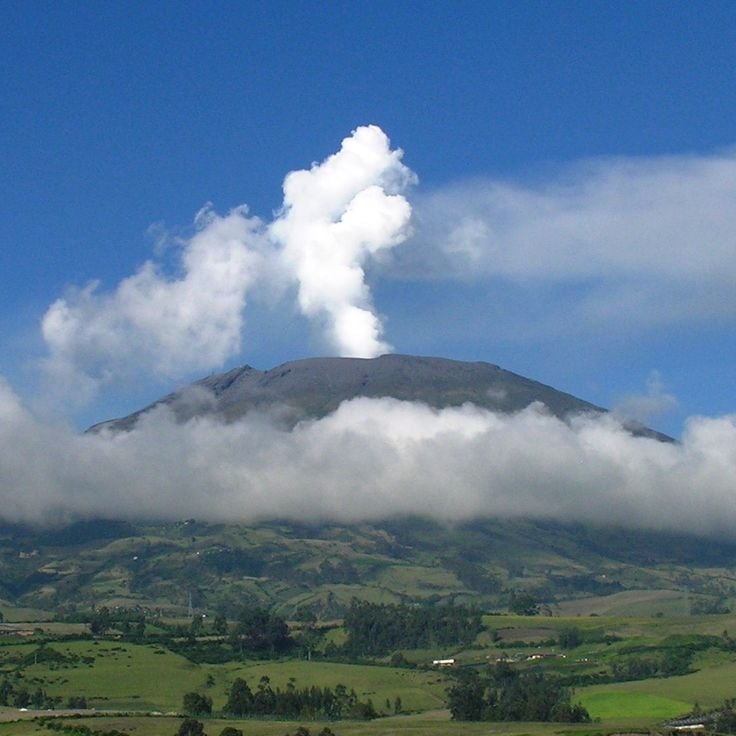
This collection brings together active volcanoes located on multiple continents, from Cotopaxi in the Ecuadorian Andes to Mount Fuji in Japan, including Vesuvius in Italy and Mauna Loa in Hawaii. Each site demonstrates different geological processes: stratovolcanoes like Mount Saint Helens and Etna produce explosive eruptions, while Hawaiian shield volcanoes generate flowing lava that can travel long distances.
The selection also includes sites that have marked history through their destructive power, such as Krakatoa, whose 1883 eruption caused tens of thousands of casualties, or Vesuvius, which buried Pompeii and Herculaneum in AD 79. Other volcanoes like Iceland's Eyjafjallajökull have recently shown their ability to disrupt human activities globally. These locations offer insight into how volcanic activity shapes landscapes and influences nearby populations.
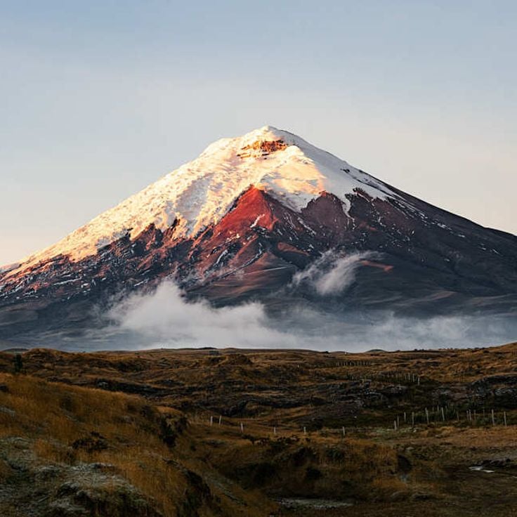
Cotopaxi rises to 19,347 feet (5,897 meters) above sea level in the Andes and represents the second highest peak in Ecuador. As one of the country's most active volcanoes, it displays various forms of volcanic activity with regular eruptions that shape its geological features. The snow-capped stratovolcano documents Earth's geological forces through its historical eruptions and ongoing volcanic activity, making it a significant example of Andean geology.
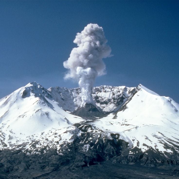
Mount Saint Helens is an active stratovolcano in the Cascade Range that gained worldwide attention through its 1980 eruption. During this eruption, the volcano lost over 1,300 feet (400 meters) of its height and destroyed surrounding forests across 230 square miles (600 square kilometers). The eruption produced a lateral blast that sent a massive ash cloud into the atmosphere and generated pyroclastic flows. This volcano demonstrates the geological processes of the Juan de Fuca Plate subducting beneath the North American Plate and remains an active research site for volcanologists.
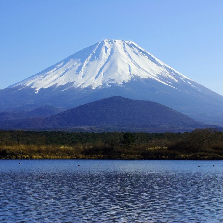
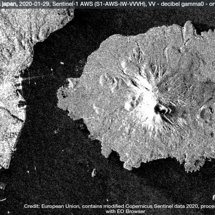
This stratovolcano on Japan's main island reaches 12,388 feet (3,776 meters) in height and has remained active since its last eruption in 1707. The mountain has shaped Japanese culture and history for centuries. Its symmetrical form and presence in art and literature make it a central element of Japanese identity. Mount Fuji is part of the collection of active volcanoes worldwide that document Earth's geological forces. Its past eruptions and continued seismic activity demonstrate the volcanic processes that shape the Earth's crust.
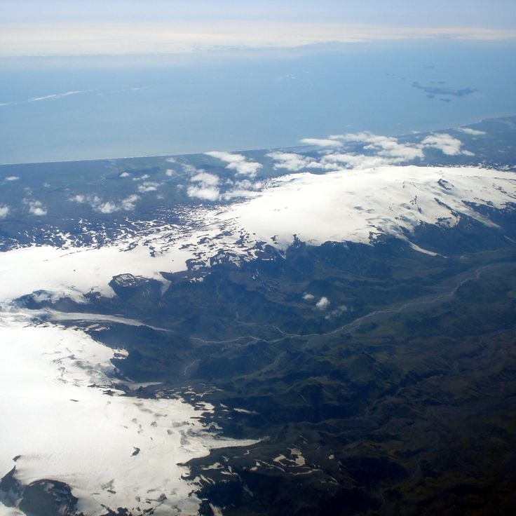
Eyjafjallajökull sits beneath a glacier at 5,465 feet (1,666 meters) in southern Iceland. This volcano last erupted in 2010, producing an ash cloud that led to extensive flight restrictions across Europe. The eruption lasted several weeks and significantly affected international air travel. The volcano forms a distinctive geological feature of Iceland together with its glacier and documents volcanic activity along the Mid-Atlantic Ridge zone.
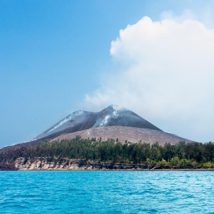
Krakatoa sits in the Sunda Strait between Java and Sumatra. This volcano experienced one of the most powerful documented eruptions in history during August 1883, claiming approximately 36,000 lives. The explosion destroyed two thirds of the original island and generated tsunami waves that devastated coastal communities throughout the region. The eruption caused atmospheric disturbances observed worldwide, including temperature drops and unusual sunsets for several years. Since 1927, a new volcanic cone called Anak Krakatau (Child of Krakatoa) has been growing at this location, remaining active and documenting the ongoing geological processes within this volcanic zone.
This shield volcano on the Big Island extends over 5000 square kilometers (1900 square miles) and rises 4169 meters (13678 feet) above sea level. Mauna Loa is among the most active volcanoes on Earth, documenting basaltic volcanic activity through regular eruptions that contribute to the expansion of the Hawaiian island chain. Its broad, flat shape results from fluid lava flows.
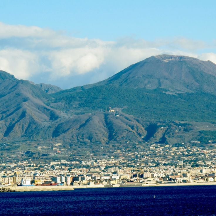
Mount Vesuvius is a stratovolcano that destroyed the Roman cities of Pompeii and Herculaneum in 79 CE through pyroclastic flows and ash fall. The volcano rises to about 4,203 feet (1,281 meters) above the Bay of Naples. The eruption of 79 CE buried both cities under several meters of volcanic material, preserving buildings, artwork, and human remains. Vesuvius is part of the Campanian volcanic arc and sits on the collision zone between the African and Eurasian tectonic plates. As the only active volcano on mainland Europe, it poses a potential hazard to the densely populated region around Naples.
Mount Etna, a volcano located south of Catania in Sicily, rises to 10,912 feet (3,326 meters), making it the highest active volcano in Europe. With over 200 lateral craters, the volcano documents a geological history dating back to 1500 BC. The eruptions of Mount Etna have shaped the landscape and life of the region for thousands of years. As one of the most active volcanoes in the world, it displays various forms of volcanic activity, from lava flows to explosive eruptions, providing insights into Earth's geological forces.
The Yellowstone Caldera is a supervolcano that spans an area of 3475 square miles (9000 square kilometers). This volcano generates numerous geothermal features, including geysers, hot springs, and mud pots. Volcanic activity beneath the surface drives these thermal phenomena, which rank among the most extensive geothermal systems in the world. The caldera formed through several massive eruptions, with the most recent occurring approximately 640,000 years ago.
Kilauea is a shield volcano in Hawaii that has been producing lava flows continuously since 1983, forming new land in the Pacific Ocean. At 4,091 feet (1,247 meters) in elevation, it ranks among the most active volcanoes on Earth. Its eruptions occur primarily from the main crater and from fissures along the rift zones. The fluid basaltic lava typically flows over considerable distances to the sea, where it solidifies upon contact with water and extends the coastline. Kilauea thus documents active volcanic processes and the ongoing transformation of the Hawaiian island chain through geological forces.
Popocatépetl is a 17,802-foot (5,426-meter) stratovolcano that regularly emits ash and releases steam clouds from its crater. This active volcano in central Mexico demonstrates ongoing volcanic activity with frequent eruptions that produce ash deposits across the surrounding region. The volcano's summit crater continuously produces steam and gas plumes visible from nearby communities.
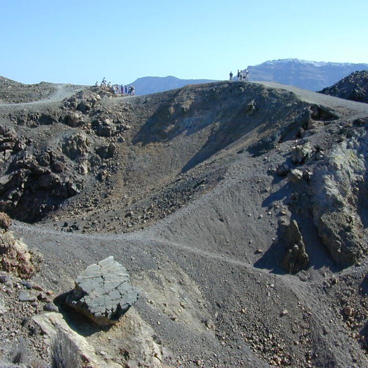
This caldera in the southern Aegean Sea formed through the collapse of a volcanic system approximately 3600 years ago. The collapse created a water-filled depression with steep cliffs rising up to 980 feet (300 meters) from the sea. The caldera documents one of the largest volcanic eruptions in human history and demonstrates geological processes occurring during highly explosive eruptions. The main crescent-shaped island and smaller islands surround the central basin, where submarine volcanic activity continues. This formation illustrates the dynamic geological forces shaping island volcanoes in the Mediterranean region.
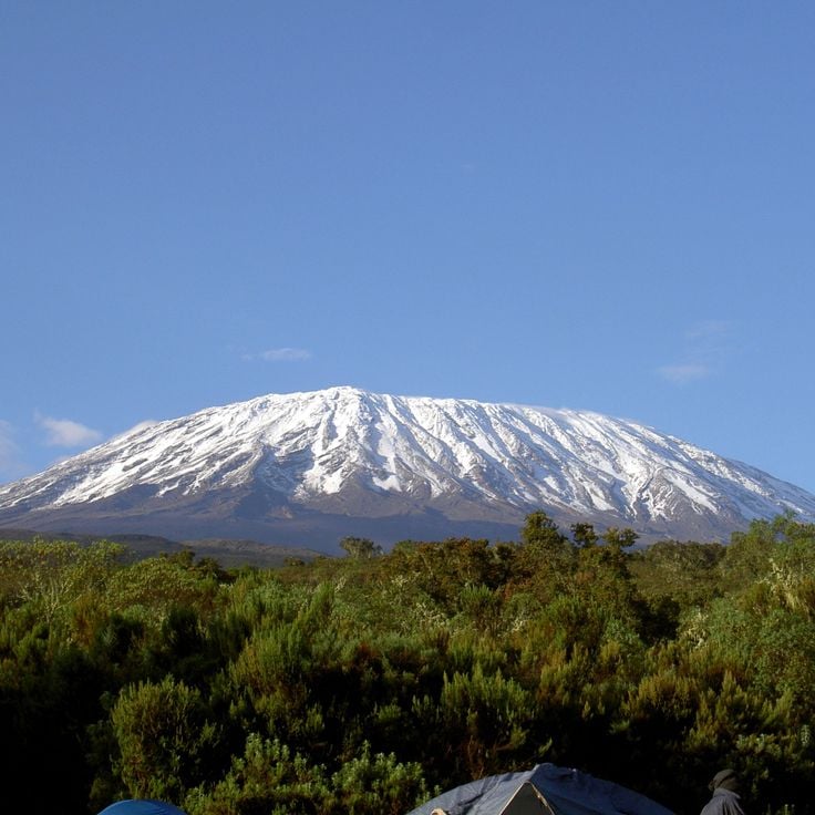
Mount Kilimanjaro is a dormant volcano in Tanzania that rises to 5,895 meters (19,341 feet), making it the highest mountain in Africa. This volcano consists of three volcanic cones: Kibo, the youngest and highest, Mawenzi, a heavily eroded peak, and Shira, the oldest and most degraded cone on the western side. Mount Kilimanjaro demonstrates different stages of volcanic development and documents geological processes spanning roughly one million years. The massif formed through repeated volcanic activity along the East African Rift and shows the tectonic forces that shaped the African highlands.
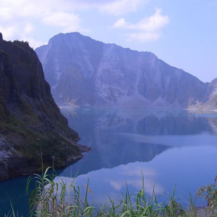
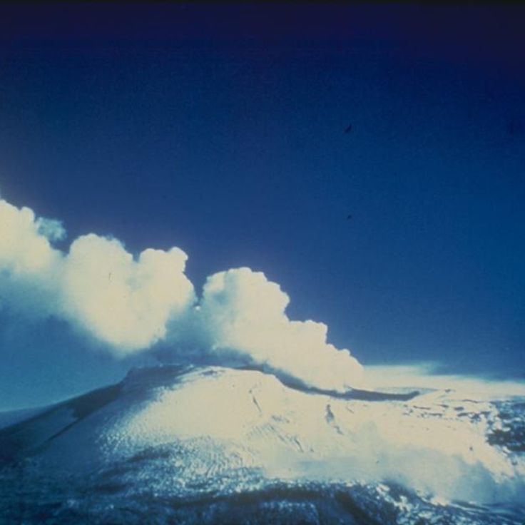
The Pinatubo sits on the Philippine island of Luzon and is a stratovolcano that remained largely quiet for centuries. In June 1991, this volcano experienced one of the most powerful eruptions of the 20th century, releasing roughly 2.4 cubic miles (10 cubic kilometers) of volcanic material. The eruption sent ash columns to heights of 115,000 feet (35 kilometers) and generated pyroclastic flows that filled several valleys. Sulfur dioxide emissions formed an aerosol layer in the stratosphere that reflected sunlight and lowered global average temperatures by about 0.9 degrees Fahrenheit (0.5 degrees Celsius) the following year. The eruption left a summit crater measuring 1.6 miles (2.5 kilometers) in diameter, which later filled with rainwater to form a crater lake. The Pinatubo documents the capacity of volcanoes to influence worldwide climate systems.
Galeras rises to 14029 feet (4276 meters) near the city of Pasto and ranks among Colombia's most active volcanoes. Since 1989, this stratovolcano has shown increased seismic activity with frequent eruptions and gas emissions. Its location near a major city makes it one of the country's most closely monitored volcanoes. The crater displays fumarolic activity, and the volcanic rocks document a long history of eruptions that illustrate geological processes of the Earth's crust.
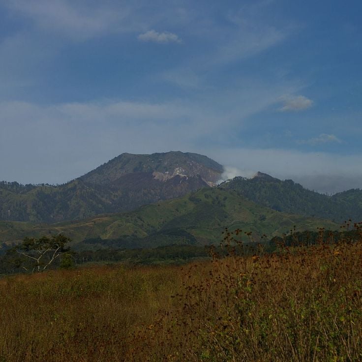
Merapi is an active stratovolcano in Indonesia that rises to 9738 feet (2968 meters). More than 80 eruptions have been documented since 1548, regularly producing pyroclastic flows. These flows of hot gas, ash, and rock fragments move down the slopes at high speed. The volcano sits on the island of Java and ranks among the most active volcanoes in the region. Its geological activity makes it a significant example of volcanism in the Pacific Ring of Fire.
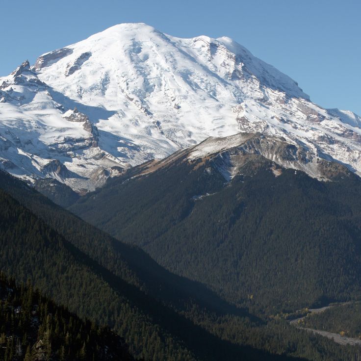
Mount Rainier is a 14,411-foot (4,392-meter) stratovolcano and the highest peak in the Cascade Range. This active volcano in western Washington ranks as one of the most hazardous volcanoes in the United States due to its proximity to the Seattle-Tacoma metropolitan area. The heavily glaciated mountain contains the largest glacier system of any single peak in the contiguous United States. Its most recent known eruptions occurred in the 19th century, but geological conditions require continuous monitoring for potential lahars that could threaten densely populated valleys.
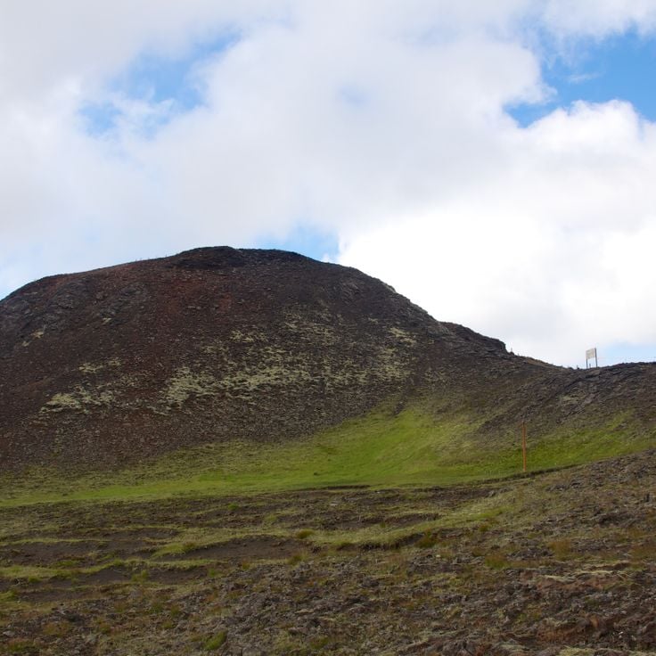
This volcano is located 12 miles (20 kilometers) from Reykjavík and contains an accessible magma chamber. Þríhnúkagígur is among the few volcanoes worldwide where visitors can descend into the empty magma chamber through guided tours. The chamber measures approximately 160 feet (50 meters) in width and 655 feet (200 meters) in depth. This underground space formed after an eruption that occurred around 4000 years ago, documenting volcanic activity in Iceland's capital region.
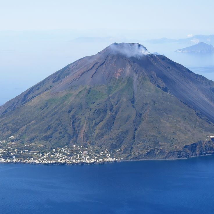
Stromboli ranks among the most active volcanoes in Europe and sits on an island in the Tyrrhenian Sea north of Sicily. This stratovolcano exhibits nearly continuous explosive eruptions that have been documented for over 2,000 years, ejecting small ash clouds and glowing rock fragments every 15 to 20 minutes. The eruption activity is so regular that it is termed Strombolian and serves as the reference for a particular volcano type worldwide. Lava flows from Stromboli descend along the Sciara del Fuoco, a steep channel on the northwest flank that runs directly into the sea. Around 500 people live on the island distributed across two settlements, residing there despite the ongoing volcanic activity.
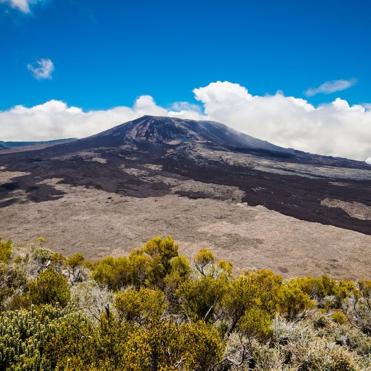
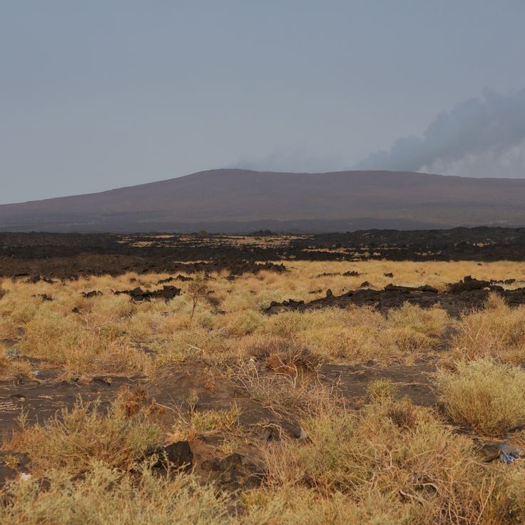
Piton de la Fournaise on Réunion Island ranks among the most active volcanoes on Earth, erupting on average every nine months. This shield volcano in the southeastern part of the island forms a central component of this collection of active volcanoes, as it produces lava flows that travel down its flanks to the Indian Ocean. The eruptions result from a mantle hotspot, similar to the Hawaiian volcanoes. The volcano lies within Réunion National Park and its Dolomieu crater reaches a depth of about 330 feet (100 meters). Recent eruptions have threatened several villages and created new land where the lava flowed into the sea.
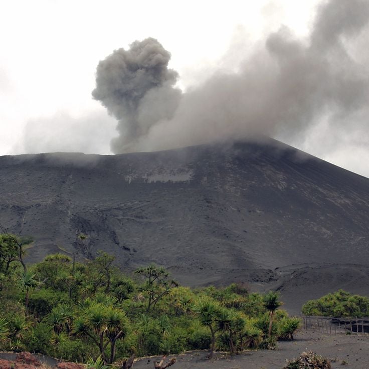
Erta Ale is a shield volcano in the Ethiopian Afar Triangle known for its persistent lava lake. This volcano forms part of the Danakil Depression and the East African Rift System, where tectonic plates are pulling apart. The summit crater contains a lava lake of molten basaltic rock at temperatures around 2000 degrees Fahrenheit (1090 degrees Celsius). Eruptions at Erta Ale produce fluid lava flows characteristic of shield volcanoes. The volcano rises about 2000 feet (610 meters) above sea level in one of the most geologically active regions in Africa.
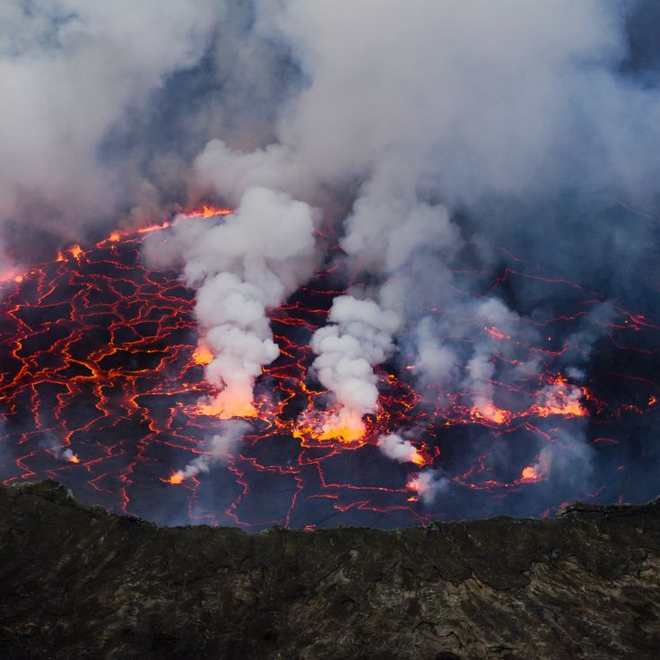
Nyiragongo is a stratovolcano in the Virunga Mountains that contains one of the world's largest lava lakes. The lava from this volcano is notable for its exceptional flow speed, which can reach velocities up to 60 miles per hour (100 kilometers per hour) during eruptions. The most recent major eruption in 2002 destroyed a significant portion of the nearby city of Goma and forced hundreds of thousands to flee. The permanent lava lake in the crater provides a window into the depths of Earth's crust and allows observation of volcanic processes that occur in other volcanoes in this collection only during eruptive phases.
Sakurajima is an active stratovolcano on Kyushu Island in Kagoshima Bay. This volcano ranks among the most active in Japan and produces regular explosive eruptions that send ash clouds several miles into the atmosphere. Since 1955, Sakurajima has been in a phase of continuous activity with frequent smaller eruptions that deposit volcanic ash on the nearby city of Kagoshima. The volcano was originally an island but became connected to the Osumi Peninsula through a massive lava flow in 1914. Residents of the region have adapted to living near this volcano and use early warning systems to monitor its activity.
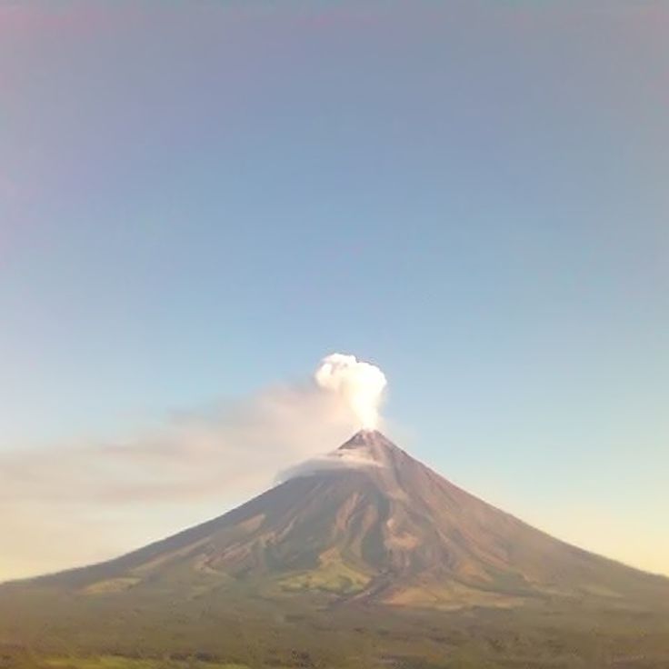
Mayon is an active stratovolcano in Albay Province on Luzon Island. The mountain rises to approximately 8,070 feet (2,460 meters) above sea level and displays a symmetrical conical shape. The volcano records regular eruptions that produce ash clouds and pyroclastic flows. The flanks of the mountain feature erosion channels that transport lahars during rainfall. Within this collection, Mayon illustrates the dynamics of Pacific stratovolcanoes, whose explosive activity results from the subduction of the Philippine Plate.
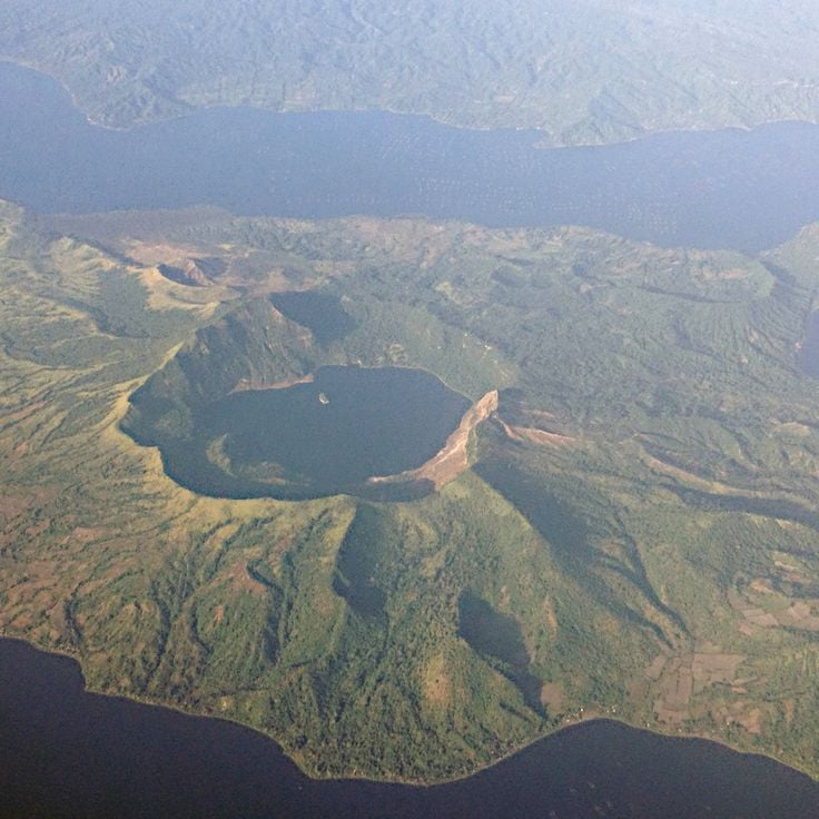
Taal on Luzon Island ranks among the most active volcanoes in the Philippines and sits about 30 miles south of Manila. This caldera formed through several explosive eruptions that caused the original volcanic structure to collapse. Within Taal Lake rises a volcanic cone that itself contains a crater lake. The system has recorded over 30 eruptions since the 16th century, including the 1911 event that claimed more than 1,300 lives. The most recent significant activity in January 2020 led to the evacuation of tens of thousands of residents from surrounding communities in Batangas Province.
Yasur is an active volcano on Tanna Island in Vanuatu that produces regular eruptions and allows visitors to observe volcanic activity at close range. This stratovolcano ejects glowing lava bombs and ash clouds several times per hour, making it one of the most accessible active volcanoes in the world. Yasur plays an important role in the lives of the local population, who have observed its activity for centuries and integrated it into their culture, while demonstrating how volcanic processes in the Pacific region shape landscapes and influence communities.
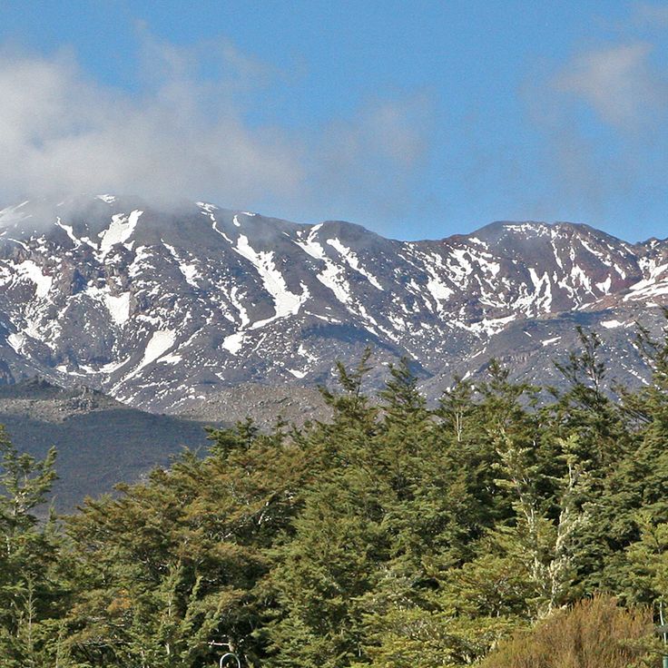
Mount Ruapehu is an active stratovolcano in Tongariro National Park on New Zealand's North Island. Standing at 9,177 feet (2,797 meters), it is the highest point on the North Island and contains a 0.2 square mile (0.5 square kilometer) crater lake at its summit. The volcano is known for its periodic eruptions, including major events in 1995 and 1996 that spread ash clouds across large portions of the region. The flanks of Mount Ruapehu support several glaciers and serve as ski areas during winter months. Its volcanic activity is monitored continuously, as sudden eruptions can occur without warning and lahar mudflows pose a hazard to surrounding valleys.
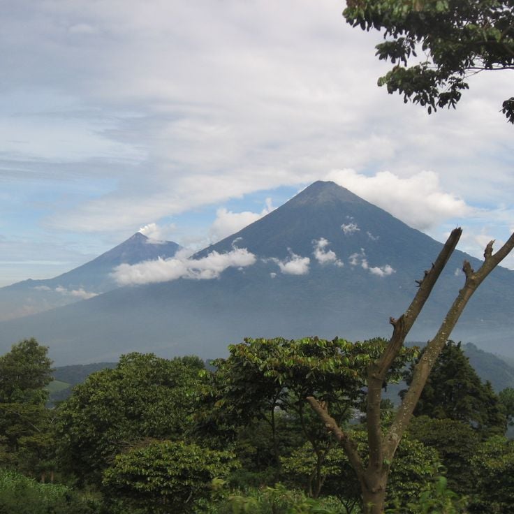
Volcán de Fuego is one of Central America's most active stratovolcanoes and ranks among Guatemala's three active volcanoes. Since its first recorded eruption in 1524, this volcano has displayed regular activity that includes explosive eruptions, pyroclastic flows, and ash emissions. The volcano rises to an elevation of 12,346 feet (3,763 meters) above sea level near the city of Antigua Guatemala. Its frequent activity has led to evacuations of surrounding communities and continues to influence the lives of local populations who practice agriculture in the region's fertile volcanic soils.
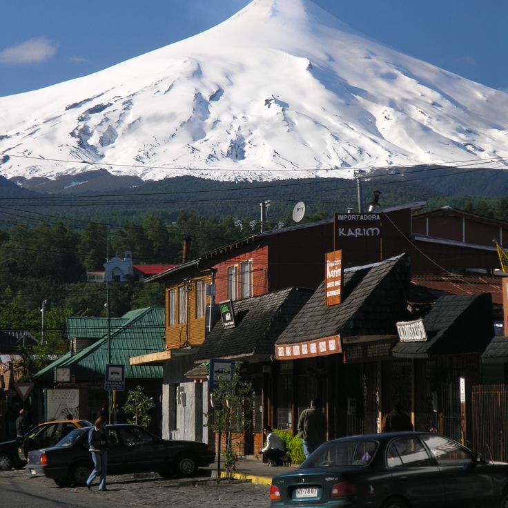
Villarrica is a stratovolcano in the Araucanía Region of Chile and ranks among the most active volcanoes in South America. The summit reaches 9,341 feet (2,847 meters) and contains a permanent lava lake within its crater. More than 60 eruptions have been documented since the 16th century, with 1971 marking a particularly intense phase. Volcanic activity manifests through regular Strombolian explosions and lava flows that have repeatedly reached the forested slopes. The volcano lies within a national park and attracts many climbers, while surrounding communities face ongoing risk from repeated eruptions.
Nevado del Ruiz is a stratovolcano in the Colombian Andes that rises approximately 17,400 feet (5,300 meters) in the Cordillera Central. This volcano features a glacial cap whose meltwater can generate lahars during eruptions. In November 1985, an eruption caused the destruction of the town of Armero, killing more than 23,000 people. The volcano's extensive glacial area feeds several regional rivers and lies within Los Nevados National Park. Volcanic activity manifests through fumaroles and seismic events that are continuously monitored.
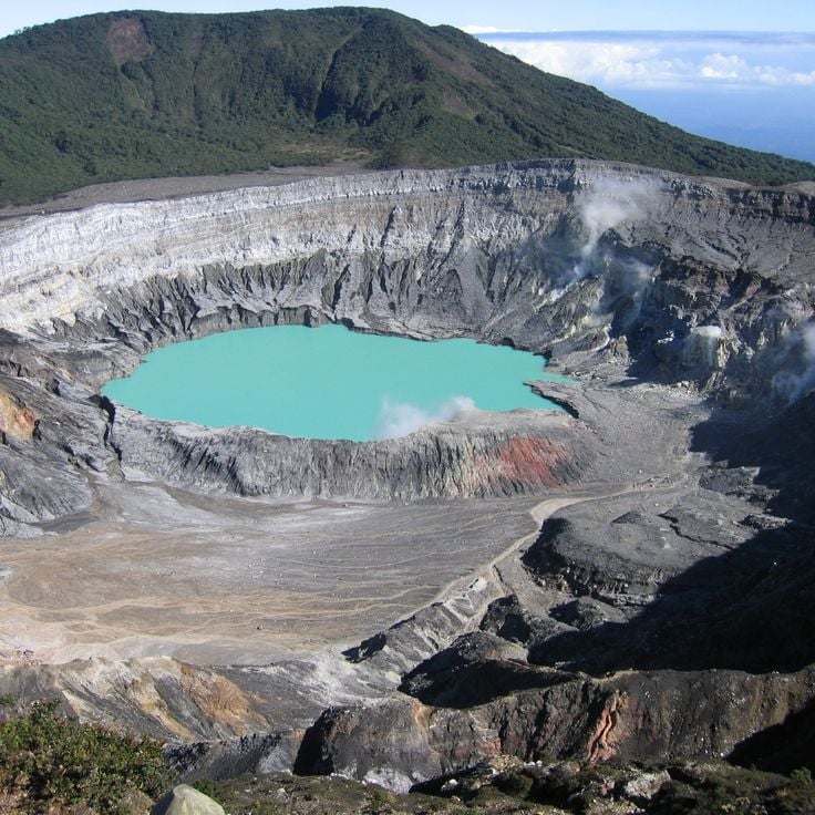
Poás is an active stratovolcano in central Costa Rica, rising about 23 miles (37 kilometers) north of the capital city San José. The mountain reaches 8885 feet (2708 meters) above sea level and hosts one of the world's largest active crater lakes. The main crater measures approximately 4265 feet (1300 meters) in diameter and extends roughly 985 feet (300 meters) in depth. Volcanic activity manifests through regular degassing, occasional geyser eruptions, and phreatic explosions that release acidic vapors and ash. The volcano sits within Poás National Park, where the surrounding highlands combine cloud forests with agricultural lands, embedding geological processes into an inhabited region. Recent eruption phases occurred between 2017 and 2018 with substantial ash emissions.
Cotopaxi rises to 19,347 feet (5,897 meters) above sea level in the Andes and represents the second highest peak in Ecuador. As one of the country's most active volcanoes, it displays various forms of volcanic activity with regular eruptions that shape its geological features. The snow-capped stratovolcano documents Earth's geological forces through its historical eruptions and ongoing volcanic activity, making it a significant example of Andean geology.
Mount Saint Helens is an active stratovolcano in the Cascade Range that gained worldwide attention through its 1980 eruption. During this eruption, the volcano lost over 1,300 feet (400 meters) of its height and destroyed surrounding forests across 230 square miles (600 square kilometers). The eruption produced a lateral blast that sent a massive ash cloud into the atmosphere and generated pyroclastic flows. This volcano demonstrates the geological processes of the Juan de Fuca Plate subducting beneath the North American Plate and remains an active research site for volcanologists.
This stratovolcano on Japan's main island reaches 12,388 feet (3,776 meters) in height and has remained active since its last eruption in 1707. The mountain has shaped Japanese culture and history for centuries. Its symmetrical form and presence in art and literature make it a central element of Japanese identity. Mount Fuji is part of the collection of active volcanoes worldwide that document Earth's geological forces. Its past eruptions and continued seismic activity demonstrate the volcanic processes that shape the Earth's crust.
Eyjafjallajökull sits beneath a glacier at 5,465 feet (1,666 meters) in southern Iceland. This volcano last erupted in 2010, producing an ash cloud that led to extensive flight restrictions across Europe. The eruption lasted several weeks and significantly affected international air travel. The volcano forms a distinctive geological feature of Iceland together with its glacier and documents volcanic activity along the Mid-Atlantic Ridge zone.
Krakatoa sits in the Sunda Strait between Java and Sumatra. This volcano experienced one of the most powerful documented eruptions in history during August 1883, claiming approximately 36,000 lives. The explosion destroyed two thirds of the original island and generated tsunami waves that devastated coastal communities throughout the region. The eruption caused atmospheric disturbances observed worldwide, including temperature drops and unusual sunsets for several years. Since 1927, a new volcanic cone called Anak Krakatau (Child of Krakatoa) has been growing at this location, remaining active and documenting the ongoing geological processes within this volcanic zone.
This shield volcano on the Big Island extends over 5000 square kilometers (1900 square miles) and rises 4169 meters (13678 feet) above sea level. Mauna Loa is among the most active volcanoes on Earth, documenting basaltic volcanic activity through regular eruptions that contribute to the expansion of the Hawaiian island chain. Its broad, flat shape results from fluid lava flows.
Mount Vesuvius is a stratovolcano that destroyed the Roman cities of Pompeii and Herculaneum in 79 CE through pyroclastic flows and ash fall. The volcano rises to about 4,203 feet (1,281 meters) above the Bay of Naples. The eruption of 79 CE buried both cities under several meters of volcanic material, preserving buildings, artwork, and human remains. Vesuvius is part of the Campanian volcanic arc and sits on the collision zone between the African and Eurasian tectonic plates. As the only active volcano on mainland Europe, it poses a potential hazard to the densely populated region around Naples.
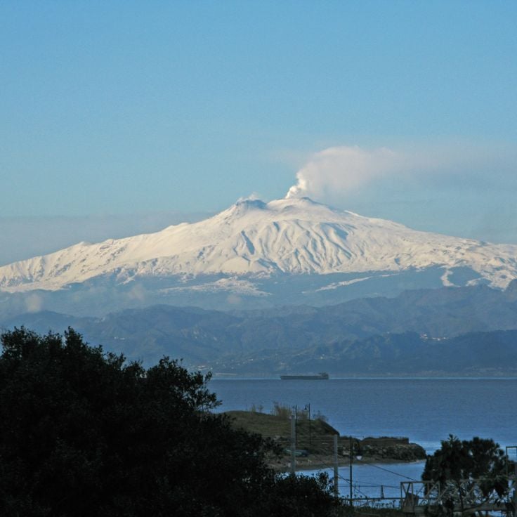
Mount Etna, a volcano located south of Catania in Sicily, rises to 10,912 feet (3,326 meters), making it the highest active volcano in Europe. With over 200 lateral craters, the volcano documents a geological history dating back to 1500 BC. The eruptions of Mount Etna have shaped the landscape and life of the region for thousands of years. As one of the most active volcanoes in the world, it displays various forms of volcanic activity, from lava flows to explosive eruptions, providing insights into Earth's geological forces.
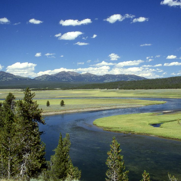
The Yellowstone Caldera is a supervolcano that spans an area of 3475 square miles (9000 square kilometers). This volcano generates numerous geothermal features, including geysers, hot springs, and mud pots. Volcanic activity beneath the surface drives these thermal phenomena, which rank among the most extensive geothermal systems in the world. The caldera formed through several massive eruptions, with the most recent occurring approximately 640,000 years ago.
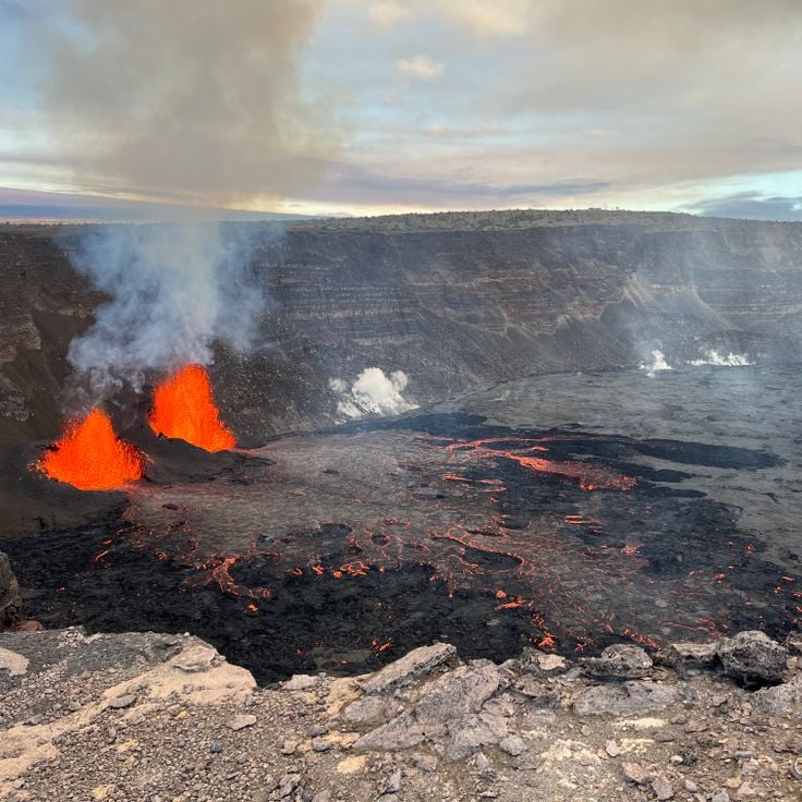
Kilauea is a shield volcano in Hawaii that has been producing lava flows continuously since 1983, forming new land in the Pacific Ocean. At 4,091 feet (1,247 meters) in elevation, it ranks among the most active volcanoes on Earth. Its eruptions occur primarily from the main crater and from fissures along the rift zones. The fluid basaltic lava typically flows over considerable distances to the sea, where it solidifies upon contact with water and extends the coastline. Kilauea thus documents active volcanic processes and the ongoing transformation of the Hawaiian island chain through geological forces.
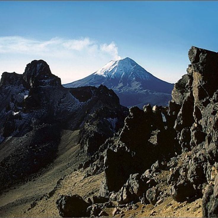
Popocatépetl is a 17,802-foot (5,426-meter) stratovolcano that regularly emits ash and releases steam clouds from its crater. This active volcano in central Mexico demonstrates ongoing volcanic activity with frequent eruptions that produce ash deposits across the surrounding region. The volcano's summit crater continuously produces steam and gas plumes visible from nearby communities.
This caldera in the southern Aegean Sea formed through the collapse of a volcanic system approximately 3600 years ago. The collapse created a water-filled depression with steep cliffs rising up to 980 feet (300 meters) from the sea. The caldera documents one of the largest volcanic eruptions in human history and demonstrates geological processes occurring during highly explosive eruptions. The main crescent-shaped island and smaller islands surround the central basin, where submarine volcanic activity continues. This formation illustrates the dynamic geological forces shaping island volcanoes in the Mediterranean region.
Mount Kilimanjaro is a dormant volcano in Tanzania that rises to 5,895 meters (19,341 feet), making it the highest mountain in Africa. This volcano consists of three volcanic cones: Kibo, the youngest and highest, Mawenzi, a heavily eroded peak, and Shira, the oldest and most degraded cone on the western side. Mount Kilimanjaro demonstrates different stages of volcanic development and documents geological processes spanning roughly one million years. The massif formed through repeated volcanic activity along the East African Rift and shows the tectonic forces that shaped the African highlands.
The Pinatubo sits on the Philippine island of Luzon and is a stratovolcano that remained largely quiet for centuries. In June 1991, this volcano experienced one of the most powerful eruptions of the 20th century, releasing roughly 2.4 cubic miles (10 cubic kilometers) of volcanic material. The eruption sent ash columns to heights of 115,000 feet (35 kilometers) and generated pyroclastic flows that filled several valleys. Sulfur dioxide emissions formed an aerosol layer in the stratosphere that reflected sunlight and lowered global average temperatures by about 0.9 degrees Fahrenheit (0.5 degrees Celsius) the following year. The eruption left a summit crater measuring 1.6 miles (2.5 kilometers) in diameter, which later filled with rainwater to form a crater lake. The Pinatubo documents the capacity of volcanoes to influence worldwide climate systems.
Galeras rises to 14029 feet (4276 meters) near the city of Pasto and ranks among Colombia's most active volcanoes. Since 1989, this stratovolcano has shown increased seismic activity with frequent eruptions and gas emissions. Its location near a major city makes it one of the country's most closely monitored volcanoes. The crater displays fumarolic activity, and the volcanic rocks document a long history of eruptions that illustrate geological processes of the Earth's crust.
Merapi is an active stratovolcano in Indonesia that rises to 9738 feet (2968 meters). More than 80 eruptions have been documented since 1548, regularly producing pyroclastic flows. These flows of hot gas, ash, and rock fragments move down the slopes at high speed. The volcano sits on the island of Java and ranks among the most active volcanoes in the region. Its geological activity makes it a significant example of volcanism in the Pacific Ring of Fire.
Mount Rainier is a 14,411-foot (4,392-meter) stratovolcano and the highest peak in the Cascade Range. This active volcano in western Washington ranks as one of the most hazardous volcanoes in the United States due to its proximity to the Seattle-Tacoma metropolitan area. The heavily glaciated mountain contains the largest glacier system of any single peak in the contiguous United States. Its most recent known eruptions occurred in the 19th century, but geological conditions require continuous monitoring for potential lahars that could threaten densely populated valleys.
This volcano is located 12 miles (20 kilometers) from Reykjavík and contains an accessible magma chamber. Þríhnúkagígur is among the few volcanoes worldwide where visitors can descend into the empty magma chamber through guided tours. The chamber measures approximately 160 feet (50 meters) in width and 655 feet (200 meters) in depth. This underground space formed after an eruption that occurred around 4000 years ago, documenting volcanic activity in Iceland's capital region.
Stromboli ranks among the most active volcanoes in Europe and sits on an island in the Tyrrhenian Sea north of Sicily. This stratovolcano exhibits nearly continuous explosive eruptions that have been documented for over 2,000 years, ejecting small ash clouds and glowing rock fragments every 15 to 20 minutes. The eruption activity is so regular that it is termed Strombolian and serves as the reference for a particular volcano type worldwide. Lava flows from Stromboli descend along the Sciara del Fuoco, a steep channel on the northwest flank that runs directly into the sea. Around 500 people live on the island distributed across two settlements, residing there despite the ongoing volcanic activity.
Piton de la Fournaise on Réunion Island ranks among the most active volcanoes on Earth, erupting on average every nine months. This shield volcano in the southeastern part of the island forms a central component of this collection of active volcanoes, as it produces lava flows that travel down its flanks to the Indian Ocean. The eruptions result from a mantle hotspot, similar to the Hawaiian volcanoes. The volcano lies within Réunion National Park and its Dolomieu crater reaches a depth of about 330 feet (100 meters). Recent eruptions have threatened several villages and created new land where the lava flowed into the sea.
Erta Ale is a shield volcano in the Ethiopian Afar Triangle known for its persistent lava lake. This volcano forms part of the Danakil Depression and the East African Rift System, where tectonic plates are pulling apart. The summit crater contains a lava lake of molten basaltic rock at temperatures around 2000 degrees Fahrenheit (1090 degrees Celsius). Eruptions at Erta Ale produce fluid lava flows characteristic of shield volcanoes. The volcano rises about 2000 feet (610 meters) above sea level in one of the most geologically active regions in Africa.
Nyiragongo is a stratovolcano in the Virunga Mountains that contains one of the world's largest lava lakes. The lava from this volcano is notable for its exceptional flow speed, which can reach velocities up to 60 miles per hour (100 kilometers per hour) during eruptions. The most recent major eruption in 2002 destroyed a significant portion of the nearby city of Goma and forced hundreds of thousands to flee. The permanent lava lake in the crater provides a window into the depths of Earth's crust and allows observation of volcanic processes that occur in other volcanoes in this collection only during eruptive phases.
Sakurajima is an active stratovolcano on Kyushu Island in Kagoshima Bay. This volcano ranks among the most active in Japan and produces regular explosive eruptions that send ash clouds several miles into the atmosphere. Since 1955, Sakurajima has been in a phase of continuous activity with frequent smaller eruptions that deposit volcanic ash on the nearby city of Kagoshima. The volcano was originally an island but became connected to the Osumi Peninsula through a massive lava flow in 1914. Residents of the region have adapted to living near this volcano and use early warning systems to monitor its activity.
Mayon is an active stratovolcano in Albay Province on Luzon Island. The mountain rises to approximately 8,070 feet (2,460 meters) above sea level and displays a symmetrical conical shape. The volcano records regular eruptions that produce ash clouds and pyroclastic flows. The flanks of the mountain feature erosion channels that transport lahars during rainfall. Within this collection, Mayon illustrates the dynamics of Pacific stratovolcanoes, whose explosive activity results from the subduction of the Philippine Plate.
Taal on Luzon Island ranks among the most active volcanoes in the Philippines and sits about 30 miles south of Manila. This caldera formed through several explosive eruptions that caused the original volcanic structure to collapse. Within Taal Lake rises a volcanic cone that itself contains a crater lake. The system has recorded over 30 eruptions since the 16th century, including the 1911 event that claimed more than 1,300 lives. The most recent significant activity in January 2020 led to the evacuation of tens of thousands of residents from surrounding communities in Batangas Province.
Yasur is an active volcano on Tanna Island in Vanuatu that produces regular eruptions and allows visitors to observe volcanic activity at close range. This stratovolcano ejects glowing lava bombs and ash clouds several times per hour, making it one of the most accessible active volcanoes in the world. Yasur plays an important role in the lives of the local population, who have observed its activity for centuries and integrated it into their culture, while demonstrating how volcanic processes in the Pacific region shape landscapes and influence communities.
Mount Ruapehu is an active stratovolcano in Tongariro National Park on New Zealand's North Island. Standing at 9,177 feet (2,797 meters), it is the highest point on the North Island and contains a 0.2 square mile (0.5 square kilometer) crater lake at its summit. The volcano is known for its periodic eruptions, including major events in 1995 and 1996 that spread ash clouds across large portions of the region. The flanks of Mount Ruapehu support several glaciers and serve as ski areas during winter months. Its volcanic activity is monitored continuously, as sudden eruptions can occur without warning and lahar mudflows pose a hazard to surrounding valleys.
Volcán de Fuego is one of Central America's most active stratovolcanoes and ranks among Guatemala's three active volcanoes. Since its first recorded eruption in 1524, this volcano has displayed regular activity that includes explosive eruptions, pyroclastic flows, and ash emissions. The volcano rises to an elevation of 12,346 feet (3,763 meters) above sea level near the city of Antigua Guatemala. Its frequent activity has led to evacuations of surrounding communities and continues to influence the lives of local populations who practice agriculture in the region's fertile volcanic soils.
Villarrica is a stratovolcano in the Araucanía Region of Chile and ranks among the most active volcanoes in South America. The summit reaches 9,341 feet (2,847 meters) and contains a permanent lava lake within its crater. More than 60 eruptions have been documented since the 16th century, with 1971 marking a particularly intense phase. Volcanic activity manifests through regular Strombolian explosions and lava flows that have repeatedly reached the forested slopes. The volcano lies within a national park and attracts many climbers, while surrounding communities face ongoing risk from repeated eruptions.
Nevado del Ruiz is a stratovolcano in the Colombian Andes that rises approximately 17,400 feet (5,300 meters) in the Cordillera Central. This volcano features a glacial cap whose meltwater can generate lahars during eruptions. In November 1985, an eruption caused the destruction of the town of Armero, killing more than 23,000 people. The volcano's extensive glacial area feeds several regional rivers and lies within Los Nevados National Park. Volcanic activity manifests through fumaroles and seismic events that are continuously monitored.
Poás is an active stratovolcano in central Costa Rica, rising about 23 miles (37 kilometers) north of the capital city San José. The mountain reaches 8885 feet (2708 meters) above sea level and hosts one of the world's largest active crater lakes. The main crater measures approximately 4265 feet (1300 meters) in diameter and extends roughly 985 feet (300 meters) in depth. Volcanic activity manifests through regular degassing, occasional geyser eruptions, and phreatic explosions that release acidic vapors and ash. The volcano sits within Poás National Park, where the surrounding highlands combine cloud forests with agricultural lands, embedding geological processes into an inhabited region. Recent eruption phases occurred between 2017 and 2018 with substantial ash emissions.
Cotopaxi rises to 19,347 feet (5,897 meters) above sea level in the Andes and represents the second highest peak in Ecuador. As one of the country's most active volcanoes, it displays various forms of volcanic activity with regular eruptions that shape its geological features. The snow-capped stratovolcano documents Earth's geological forces through its historical eruptions and ongoing volcanic activity, making it a significant example of Andean geology.
Mount Saint Helens is an active stratovolcano in the Cascade Range that gained worldwide attention through its 1980 eruption. During this eruption, the volcano lost over 1,300 feet (400 meters) of its height and destroyed surrounding forests across 230 square miles (600 square kilometers). The eruption produced a lateral blast that sent a massive ash cloud into the atmosphere and generated pyroclastic flows. This volcano demonstrates the geological processes of the Juan de Fuca Plate subducting beneath the North American Plate and remains an active research site for volcanologists.
This stratovolcano on Japan's main island reaches 12,388 feet (3,776 meters) in height and has remained active since its last eruption in 1707. The mountain has shaped Japanese culture and history for centuries. Its symmetrical form and presence in art and literature make it a central element of Japanese identity. Mount Fuji is part of the collection of active volcanoes worldwide that document Earth's geological forces. Its past eruptions and continued seismic activity demonstrate the volcanic processes that shape the Earth's crust.
Eyjafjallajökull sits beneath a glacier at 5,465 feet (1,666 meters) in southern Iceland. This volcano last erupted in 2010, producing an ash cloud that led to extensive flight restrictions across Europe. The eruption lasted several weeks and significantly affected international air travel. The volcano forms a distinctive geological feature of Iceland together with its glacier and documents volcanic activity along the Mid-Atlantic Ridge zone.
Krakatoa sits in the Sunda Strait between Java and Sumatra. This volcano experienced one of the most powerful documented eruptions in history during August 1883, claiming approximately 36,000 lives. The explosion destroyed two thirds of the original island and generated tsunami waves that devastated coastal communities throughout the region. The eruption caused atmospheric disturbances observed worldwide, including temperature drops and unusual sunsets for several years. Since 1927, a new volcanic cone called Anak Krakatau (Child of Krakatoa) has been growing at this location, remaining active and documenting the ongoing geological processes within this volcanic zone.
This shield volcano on the Big Island extends over 5000 square kilometers (1900 square miles) and rises 4169 meters (13678 feet) above sea level. Mauna Loa is among the most active volcanoes on Earth, documenting basaltic volcanic activity through regular eruptions that contribute to the expansion of the Hawaiian island chain. Its broad, flat shape results from fluid lava flows.
Mount Vesuvius is a stratovolcano that destroyed the Roman cities of Pompeii and Herculaneum in 79 CE through pyroclastic flows and ash fall. The volcano rises to about 4,203 feet (1,281 meters) above the Bay of Naples. The eruption of 79 CE buried both cities under several meters of volcanic material, preserving buildings, artwork, and human remains. Vesuvius is part of the Campanian volcanic arc and sits on the collision zone between the African and Eurasian tectonic plates. As the only active volcano on mainland Europe, it poses a potential hazard to the densely populated region around Naples.
Mount Etna, a volcano located south of Catania in Sicily, rises to 10,912 feet (3,326 meters), making it the highest active volcano in Europe. With over 200 lateral craters, the volcano documents a geological history dating back to 1500 BC. The eruptions of Mount Etna have shaped the landscape and life of the region for thousands of years. As one of the most active volcanoes in the world, it displays various forms of volcanic activity, from lava flows to explosive eruptions, providing insights into Earth's geological forces.
The Yellowstone Caldera is a supervolcano that spans an area of 3475 square miles (9000 square kilometers). This volcano generates numerous geothermal features, including geysers, hot springs, and mud pots. Volcanic activity beneath the surface drives these thermal phenomena, which rank among the most extensive geothermal systems in the world. The caldera formed through several massive eruptions, with the most recent occurring approximately 640,000 years ago.
Kilauea is a shield volcano in Hawaii that has been producing lava flows continuously since 1983, forming new land in the Pacific Ocean. At 4,091 feet (1,247 meters) in elevation, it ranks among the most active volcanoes on Earth. Its eruptions occur primarily from the main crater and from fissures along the rift zones. The fluid basaltic lava typically flows over considerable distances to the sea, where it solidifies upon contact with water and extends the coastline. Kilauea thus documents active volcanic processes and the ongoing transformation of the Hawaiian island chain through geological forces.
Popocatépetl is a 17,802-foot (5,426-meter) stratovolcano that regularly emits ash and releases steam clouds from its crater. This active volcano in central Mexico demonstrates ongoing volcanic activity with frequent eruptions that produce ash deposits across the surrounding region. The volcano's summit crater continuously produces steam and gas plumes visible from nearby communities.
This caldera in the southern Aegean Sea formed through the collapse of a volcanic system approximately 3600 years ago. The collapse created a water-filled depression with steep cliffs rising up to 980 feet (300 meters) from the sea. The caldera documents one of the largest volcanic eruptions in human history and demonstrates geological processes occurring during highly explosive eruptions. The main crescent-shaped island and smaller islands surround the central basin, where submarine volcanic activity continues. This formation illustrates the dynamic geological forces shaping island volcanoes in the Mediterranean region.
Mount Kilimanjaro is a dormant volcano in Tanzania that rises to 5,895 meters (19,341 feet), making it the highest mountain in Africa. This volcano consists of three volcanic cones: Kibo, the youngest and highest, Mawenzi, a heavily eroded peak, and Shira, the oldest and most degraded cone on the western side. Mount Kilimanjaro demonstrates different stages of volcanic development and documents geological processes spanning roughly one million years. The massif formed through repeated volcanic activity along the East African Rift and shows the tectonic forces that shaped the African highlands.
The Pinatubo sits on the Philippine island of Luzon and is a stratovolcano that remained largely quiet for centuries. In June 1991, this volcano experienced one of the most powerful eruptions of the 20th century, releasing roughly 2.4 cubic miles (10 cubic kilometers) of volcanic material. The eruption sent ash columns to heights of 115,000 feet (35 kilometers) and generated pyroclastic flows that filled several valleys. Sulfur dioxide emissions formed an aerosol layer in the stratosphere that reflected sunlight and lowered global average temperatures by about 0.9 degrees Fahrenheit (0.5 degrees Celsius) the following year. The eruption left a summit crater measuring 1.6 miles (2.5 kilometers) in diameter, which later filled with rainwater to form a crater lake. The Pinatubo documents the capacity of volcanoes to influence worldwide climate systems.
Galeras rises to 14029 feet (4276 meters) near the city of Pasto and ranks among Colombia's most active volcanoes. Since 1989, this stratovolcano has shown increased seismic activity with frequent eruptions and gas emissions. Its location near a major city makes it one of the country's most closely monitored volcanoes. The crater displays fumarolic activity, and the volcanic rocks document a long history of eruptions that illustrate geological processes of the Earth's crust.
Merapi is an active stratovolcano in Indonesia that rises to 9738 feet (2968 meters). More than 80 eruptions have been documented since 1548, regularly producing pyroclastic flows. These flows of hot gas, ash, and rock fragments move down the slopes at high speed. The volcano sits on the island of Java and ranks among the most active volcanoes in the region. Its geological activity makes it a significant example of volcanism in the Pacific Ring of Fire.
Mount Rainier is a 14,411-foot (4,392-meter) stratovolcano and the highest peak in the Cascade Range. This active volcano in western Washington ranks as one of the most hazardous volcanoes in the United States due to its proximity to the Seattle-Tacoma metropolitan area. The heavily glaciated mountain contains the largest glacier system of any single peak in the contiguous United States. Its most recent known eruptions occurred in the 19th century, but geological conditions require continuous monitoring for potential lahars that could threaten densely populated valleys.
This volcano is located 12 miles (20 kilometers) from Reykjavík and contains an accessible magma chamber. Þríhnúkagígur is among the few volcanoes worldwide where visitors can descend into the empty magma chamber through guided tours. The chamber measures approximately 160 feet (50 meters) in width and 655 feet (200 meters) in depth. This underground space formed after an eruption that occurred around 4000 years ago, documenting volcanic activity in Iceland's capital region.
Stromboli ranks among the most active volcanoes in Europe and sits on an island in the Tyrrhenian Sea north of Sicily. This stratovolcano exhibits nearly continuous explosive eruptions that have been documented for over 2,000 years, ejecting small ash clouds and glowing rock fragments every 15 to 20 minutes. The eruption activity is so regular that it is termed Strombolian and serves as the reference for a particular volcano type worldwide. Lava flows from Stromboli descend along the Sciara del Fuoco, a steep channel on the northwest flank that runs directly into the sea. Around 500 people live on the island distributed across two settlements, residing there despite the ongoing volcanic activity.
Piton de la Fournaise on Réunion Island ranks among the most active volcanoes on Earth, erupting on average every nine months. This shield volcano in the southeastern part of the island forms a central component of this collection of active volcanoes, as it produces lava flows that travel down its flanks to the Indian Ocean. The eruptions result from a mantle hotspot, similar to the Hawaiian volcanoes. The volcano lies within Réunion National Park and its Dolomieu crater reaches a depth of about 330 feet (100 meters). Recent eruptions have threatened several villages and created new land where the lava flowed into the sea.
Erta Ale is a shield volcano in the Ethiopian Afar Triangle known for its persistent lava lake. This volcano forms part of the Danakil Depression and the East African Rift System, where tectonic plates are pulling apart. The summit crater contains a lava lake of molten basaltic rock at temperatures around 2000 degrees Fahrenheit (1090 degrees Celsius). Eruptions at Erta Ale produce fluid lava flows characteristic of shield volcanoes. The volcano rises about 2000 feet (610 meters) above sea level in one of the most geologically active regions in Africa.
Nyiragongo is a stratovolcano in the Virunga Mountains that contains one of the world's largest lava lakes. The lava from this volcano is notable for its exceptional flow speed, which can reach velocities up to 60 miles per hour (100 kilometers per hour) during eruptions. The most recent major eruption in 2002 destroyed a significant portion of the nearby city of Goma and forced hundreds of thousands to flee. The permanent lava lake in the crater provides a window into the depths of Earth's crust and allows observation of volcanic processes that occur in other volcanoes in this collection only during eruptive phases.
Sakurajima is an active stratovolcano on Kyushu Island in Kagoshima Bay. This volcano ranks among the most active in Japan and produces regular explosive eruptions that send ash clouds several miles into the atmosphere. Since 1955, Sakurajima has been in a phase of continuous activity with frequent smaller eruptions that deposit volcanic ash on the nearby city of Kagoshima. The volcano was originally an island but became connected to the Osumi Peninsula through a massive lava flow in 1914. Residents of the region have adapted to living near this volcano and use early warning systems to monitor its activity.
Mayon is an active stratovolcano in Albay Province on Luzon Island. The mountain rises to approximately 8,070 feet (2,460 meters) above sea level and displays a symmetrical conical shape. The volcano records regular eruptions that produce ash clouds and pyroclastic flows. The flanks of the mountain feature erosion channels that transport lahars during rainfall. Within this collection, Mayon illustrates the dynamics of Pacific stratovolcanoes, whose explosive activity results from the subduction of the Philippine Plate.
Taal on Luzon Island ranks among the most active volcanoes in the Philippines and sits about 30 miles south of Manila. This caldera formed through several explosive eruptions that caused the original volcanic structure to collapse. Within Taal Lake rises a volcanic cone that itself contains a crater lake. The system has recorded over 30 eruptions since the 16th century, including the 1911 event that claimed more than 1,300 lives. The most recent significant activity in January 2020 led to the evacuation of tens of thousands of residents from surrounding communities in Batangas Province.
Yasur is an active volcano on Tanna Island in Vanuatu that produces regular eruptions and allows visitors to observe volcanic activity at close range. This stratovolcano ejects glowing lava bombs and ash clouds several times per hour, making it one of the most accessible active volcanoes in the world. Yasur plays an important role in the lives of the local population, who have observed its activity for centuries and integrated it into their culture, while demonstrating how volcanic processes in the Pacific region shape landscapes and influence communities.
Mount Ruapehu is an active stratovolcano in Tongariro National Park on New Zealand's North Island. Standing at 9,177 feet (2,797 meters), it is the highest point on the North Island and contains a 0.2 square mile (0.5 square kilometer) crater lake at its summit. The volcano is known for its periodic eruptions, including major events in 1995 and 1996 that spread ash clouds across large portions of the region. The flanks of Mount Ruapehu support several glaciers and serve as ski areas during winter months. Its volcanic activity is monitored continuously, as sudden eruptions can occur without warning and lahar mudflows pose a hazard to surrounding valleys.
Volcán de Fuego is one of Central America's most active stratovolcanoes and ranks among Guatemala's three active volcanoes. Since its first recorded eruption in 1524, this volcano has displayed regular activity that includes explosive eruptions, pyroclastic flows, and ash emissions. The volcano rises to an elevation of 12,346 feet (3,763 meters) above sea level near the city of Antigua Guatemala. Its frequent activity has led to evacuations of surrounding communities and continues to influence the lives of local populations who practice agriculture in the region's fertile volcanic soils.
Villarrica is a stratovolcano in the Araucanía Region of Chile and ranks among the most active volcanoes in South America. The summit reaches 9,341 feet (2,847 meters) and contains a permanent lava lake within its crater. More than 60 eruptions have been documented since the 16th century, with 1971 marking a particularly intense phase. Volcanic activity manifests through regular Strombolian explosions and lava flows that have repeatedly reached the forested slopes. The volcano lies within a national park and attracts many climbers, while surrounding communities face ongoing risk from repeated eruptions.
Nevado del Ruiz is a stratovolcano in the Colombian Andes that rises approximately 17,400 feet (5,300 meters) in the Cordillera Central. This volcano features a glacial cap whose meltwater can generate lahars during eruptions. In November 1985, an eruption caused the destruction of the town of Armero, killing more than 23,000 people. The volcano's extensive glacial area feeds several regional rivers and lies within Los Nevados National Park. Volcanic activity manifests through fumaroles and seismic events that are continuously monitored.
Poás is an active stratovolcano in central Costa Rica, rising about 23 miles (37 kilometers) north of the capital city San José. The mountain reaches 8885 feet (2708 meters) above sea level and hosts one of the world's largest active crater lakes. The main crater measures approximately 4265 feet (1300 meters) in diameter and extends roughly 985 feet (300 meters) in depth. Volcanic activity manifests through regular degassing, occasional geyser eruptions, and phreatic explosions that release acidic vapors and ash. The volcano sits within Poás National Park, where the surrounding highlands combine cloud forests with agricultural lands, embedding geological processes into an inhabited region. Recent eruption phases occurred between 2017 and 2018 with substantial ash emissions.