Enable Location

We need your location to show you interesting places around you

Discover nearby places

Find interesting locations and hidden gems around you

Precise directions

Get accurate directions and distances to places

Your location is never shared with other users. It's only used when you tap the location button.

Aleutians West Census Area

Log in to your account

Start exploring — it's free

Trusted by 61,349 travelers worldwide

Continue with Google
Continue with Apple
or

We will send you a code to connect

By continuing, you accept our Terms and Conditions and our Privacy Policy

Check your inbox

We've sent a pincode in your inbox. Please enter the code below.

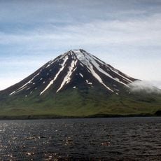
Aleutians West Census Area, Census area in western Alaska, United States

Description

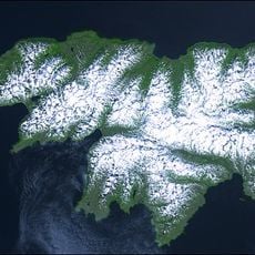
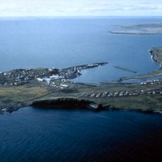
The Aleutians West Census Area is a sparsely populated administrative region in western Alaska that spreads across hundreds of miles of ocean and consists of numerous islands. The area includes the Aleutian Islands themselves as well as several other island groups that sit in cold waters between the Pacific Ocean and the Bering Sea.

History

The administrative region was established in 1980 by the US Census Bureau as a statistical district to better conduct census activities in this sparsely populated part of Alaska. The islands themselves, however, had been home to Aleutian peoples for thousands of years long before this modern administrative division was created.

Culture

The Aleutian islands have been home to Aleut peoples for thousands of years, and their descendants continue to live in today's communities while maintaining strong ties to the sea. This connection shapes daily life and local work, where fishing and seafood processing remain central to how people earn their living.

Practical

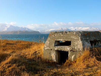
The islands are not connected by roads, so airplanes and boats are the only ways to travel between communities or reach the area. Visitors should expect unpredictable weather, long waits for transportation, and limited supply options, since logistics are challenging in this remote region.

Did you know?

The westernmost point of the United States sits on Attu Island within this area, while the Pribilof Islands further east in the Bering Sea hold critical importance for seal populations. This meeting of geographic extremes makes the region a place of global navigational and ecological importance.

Location
Inception
1980
Elevation above the sea
270 m
GPS coordinates
52.16298,-174.28505
Latest update
December 23, 2025 13:41

AroundUs brings together thousands of curated places, local tips, and hidden gems, enriched daily by 60,000 contributors worldwide. Discover all places nearby (Unorganized Borough).

Around this place
Attu Island
United States of America

Attu Island

869.9 km
Mount Cleveland
United States of America

Mount Cleveland

303.1 km
COBRA DANE
United States of America

COBRA DANE

790.3 km
Mount Okmok
United States of America

Mount Okmok

434.1 km
Dutch Harbor Naval Operating Base and Fort Mears, U.S. Army
United States of America

Dutch Harbor Naval Operating Base and Fort Mears, U.S. Army

553.6 km
Atka B-24D Liberator
United States of America

Atka B-24D Liberator

60.1 km
Alaska Maritime National Wildlife Refuge
United States of America

Alaska Maritime National Wildlife Refuge

26.6 km
Japanese Occupation Site, Kiska Island
United States of America

Japanese Occupation Site, Kiska Island

560.2 km
Mount Akutan
United States of America

Mount Akutan

595.5 km
Makushin Volcano
United States of America

Makushin Volcano

528.8 km
Mount Vsevidof
United States of America

Mount Vsevidof

392.5 km
SS Northwestern
United States of America

SS Northwestern

546.4 km
Mount Adagdak
United States of America

Mount Adagdak

158.6 km
Gareloi Volcano
United States of America

Gareloi Volcano

312.6 km
United States of America

Aleutian Islands Wilderness

51.4 km
Kanaga Volcano
United States of America

Kanaga Volcano

199.2 km
United States of America

Aleutian World War II National Historic Area

553.5 km
Cape Field at Fort Glenn
United States of America

Cape Field at Fort Glenn

451.3 km
Mount Amukta
United States of America

Mount Amukta

209.4 km
Mount Carlisle
United States of America

Mount Carlisle

297.5 km
Sts. Peter and Paul Church
United States of America

Sts. Peter and Paul Church

609 km
Davidof Volcano
United States of America

Davidof Volcano

506.1 km
Bogoslof Wilderness
United States of America

Bogoslof Wilderness

462 km
United States of America

Bering Sea Wilderness

924.7 km
United States of America

Akutan Hot Springs

602.4 km
Seal Island Historic District
United States of America

Seal Island Historic District

594.8 km
United States of America

Walrus Island

624.4 km
Mount Gilbert
United States of America

Mount Gilbert

619.7 km
Show the full map
« Aleutians West Census Area - Census area in western Alaska, United States » is provided by Around Us (aroundus.com). Images and texts are derived from Wikimedia project under a Creative Commons license. You are allowed to copy, distribute, and modify copies of this page, under the conditions set by the license, as long as this note is clearly visible.

Discover hidden gems everywhere you go!

From secret cafés to breathtaking viewpoints, skip the crowded tourist spots and find places that match your style. Our app makes it easy with voice search, smart filtering, route optimization, and insider tips from travelers worldwide. Download now for the complete mobile experience.

Around Us App Screenshot

A unique approach to discovering new places

Le Figaro

All the places worth exploring

France Info

A tailor-made excursion in just a few clicks

20 Minutes

Around Us
Travel Guide & Maps
Download

Send to your phone

QR Code
1

Open the camera app on your mobile.

2

Point at the QR code with your camera. A notification will appear.

3

Tap the notification to open the link.