Enable Location

We need your location to show you interesting places around you

Discover nearby places

Find interesting locations and hidden gems around you

Precise directions

Get accurate directions and distances to places

Your location is never shared with other users. It's only used when you tap the location button.

Log in to your account

Start exploring — it's free

Trusted by 62,574 travelers worldwide

Continue with Google
Continue with Apple
or

We will send you a code to connect

By continuing, you accept our Terms and Conditions and our Privacy Policy

Check your inbox

We've sent a pincode in your inbox. Please enter the code below.

Rice Valley Wilderness

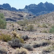
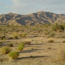
Rice Valley Wilderness, Desert wilderness area near Blythe, California, US

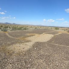
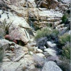
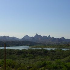
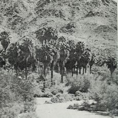
Rice Valley Wilderness is a protected desert area located southeast of Blythe, covering around 17,000 acres with sand and sparse vegetation. The landscape features a distinctive band of sand dunes that rise noticeably above the valley floor, creating the primary geographic characteristic of the terrain.

The wilderness was officially designated in 1994 through federal legislation that recognized the need to protect the California desert ecosystem. Since then, the area has remained protected from development and industrial activities.

The area attracts nature enthusiasts who visit to experience the remote desert landscape far from urban areas. Local communities value the wilderness for its role in preserving the natural habitat and providing a place for outdoor exploration.

Visitors must park well away from all roads before exploring on foot, with specific distances required depending on the road type. The area has no facilities, water sources, or shade, so come prepared with supplies and appropriate desert gear.

The sand dunes are part of a larger continuous system that stretches across multiple valleys in the California Desert, making this a significant example of dune formation in the region. Few visitors realize how extensive this dune network truly is compared to other desert features in the area.

The community of curious travelers

AroundUs brings together thousands of curated places, local tips, and hidden gems, enriched daily by 60,000 contributors worldwide.

Start exploring
GPS coordinates
33.94830,-114.74500
Latest update
December 12, 2025 09:04
Around this place
London Bridge
United States of America

London Bridge

68.8 km
Lake Havasu
United States of America

Lake Havasu

68.2 km
Central Arizona Project
United States of America

Central Arizona Project

70.1 km
Blythe Intaglios
United States of America

Blythe Intaglios

25.2 km
Colorado River Aqueduct
United States of America

Colorado River Aqueduct

65.1 km
Chuckawalla Valley State Prison
United States of America

Chuckawalla Valley State Prison

45.5 km
Hi Jolly Monument
United States of America

Hi Jolly Monument

56.7 km
Old Woman meteorite
United States of America

Old Woman meteorite

83.2 km
Buckskin Mountain State Park
United States of America

Buckskin Mountain State Park

65.8 km
Old Woman Mountains Wilderness
United States of America

Old Woman Mountains Wilderness

70.6 km
The Needles
United States of America

The Needles

85.8 km
Cibola National Wildlife Refuge
United States of America

Cibola National Wildlife Refuge

71.1 km
Cattail Cove State Park
United States of America

Cattail Cove State Park

69.4 km
Old Trails Bridge
United States of America

Old Trails Bridge

88.7 km
Bill Williams River National Wildlife Refuge
United States of America

Bill Williams River National Wildlife Refuge

73.2 km
United States of America

Topock Gorge

84.3 km
Corn Springs
United States of America

Corn Springs

64.5 km
Turtle Mountains
United States of America

Turtle Mountains

38.9 km
Windsor Beach
United States of America

Windsor Beach

69.9 km
Fort Tyson
United States of America

Fort Tyson

57.8 km
Riverside Mountains
United States of America

Riverside Mountains

20.6 km
Blythe Intake
United States of America

Blythe Intake

32.1 km
Trigo Mountains Wilderness
United States of America

Trigo Mountains Wilderness

86.2 km
Mohave Canyon
United States of America

Mohave Canyon

82.7 km
Parker Jail
United States of America

Parker Jail

47.2 km
Joshua Tree Wilderness
United States of America

Joshua Tree Wilderness

60 km
Bridgewater Links
United States of America

Bridgewater Links

68.5 km
Arizona and California Railroad Bridge
United States of America

Arizona and California Railroad Bridge

47.4 km
Show the full map
« Rice Valley Wilderness - Desert wilderness area near Blythe, California, US » is provided by Around Us (aroundus.com). Images and texts are derived from Wikimedia project under a Creative Commons license. You are allowed to copy, distribute, and modify copies of this page, under the conditions set by the license, as long as this note is clearly visible.

Discover hidden gems everywhere you go!

From secret cafés to breathtaking viewpoints, skip the crowded tourist spots and find places that match your style. Our app makes it easy with voice search, smart filtering, route optimization, and insider tips from travelers worldwide. Download now for the complete mobile experience.

Around Us App Screenshot

A unique approach to discovering new places

Le Figaro

All the places worth exploring

France Info

A tailor-made excursion in just a few clicks

20 Minutes

Around Us
Travel Guide & Maps
Download

Send to your phone

QR Code
1

Open the camera app on your mobile.

2

Point at the QR code with your camera. A notification will appear.

3

Tap the notification to open the link.