Santa Isabel do Rio Negro, Municipality in Amazonas, Brazil
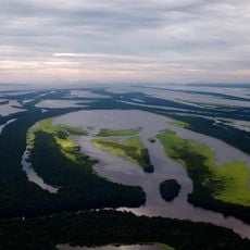
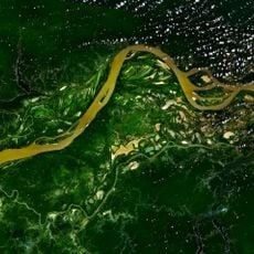
Santa Isabel do Rio Negro is a municipality in northern Amazonas, Brazil, located in an area of dense rainforests and numerous waterways. The settlement stretches along the Rio Negro and is surrounded by impenetrable forest.
The area was originally known as Tapuruquara and later became an administrative hub for the northwestern Amazon region. The settlement developed as a port for trade along the Rio Negro.
The town sits in the heart of the Amazon region, where indigenous communities have lived for generations and maintain their traditions. Visitors can experience the close relationship between people and the Rio Negro River, which shapes daily life here.
A small airport connects the municipality with other Amazon destinations and is the main arrival point for visitors. Travelers should prepare for regular rainfall and humid conditions and allow extra time for arrivals.
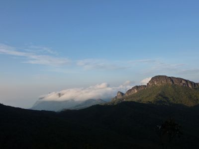
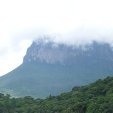
Within the municipal territory stands Pico da Neblina, Brazil's highest mountain at around 3,000 meters elevation. This striking peak lies within a protected nature area and is accessible to well-prepared hikers.
GPS coordinates: -0.25278,-64.98579
Latest update: December 8, 2025 13:43
Pico da Neblina
163.4 km
Amacayacu National Park
682.5 km
Cerro Autana
631.2 km
Piedra del Cocuy
263.2 km
Pico da Neblina National Park
124.2 km
Pico 31 de Março
163.7 km
Anavilhanas National Park
511.4 km
Jaú National Park
339.2 km
Serranía La Neblina National Park
177.7 km
Piedra del Cocuy Natural Monument
263.2 km
Jaua-Sarisariñama National Park
555.8 km
Yaigojé-Apaporis National Park
618.5 km
Parima-Tapirapecó National Park
400.1 km
Yapacana National Park
482 km
Duida-Marahuaca National Park
437.5 km
Mamirauá Sustainable Development Reserve
236.4 km
Cachoeira do El Dorado
222.1 km
Cerro Duida
415.1 km
Central Amazon Conservation Complex
404.3 km
Morro dos Seis Lagos Biological Reserve
200.3 km
Serra da Mocidade National Park
382.4 km
Central Amazon Ecological Corridor
473.2 km
Serra do Aracá State Park
270.7 km
Viruá National Park
462.3 km
Médio Juruá Extractive Reserve
664.5 km
Forte de São José de Marabitanas
251.6 km
Rio Negro Left Bank Environmental Protection Area
545.3 km
Tefé National Forest
362.6 kmVisited this place? Tap the stars to rate it and share your experience / photos with the community! Try now! You can cancel it anytime.
Discover hidden gems everywhere you go!
From secret cafés to breathtaking viewpoints, skip the crowded tourist spots and find places that match your style. Our app makes it easy with voice search, smart filtering, route optimization, and insider tips from travelers worldwide. Download now for the complete mobile experience.
A unique approach to discovering new places❞
— Le Figaro
All the places worth exploring❞
— France Info
A tailor-made excursion in just a few clicks❞
— 20 Minutes