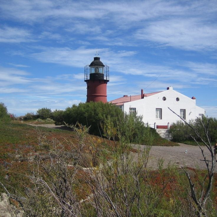
Argentina reveals beyond Buenos Aires, its capital, a world of canyons with red rock walls, granite mountains, and wetlands where caimans and capybaras live.
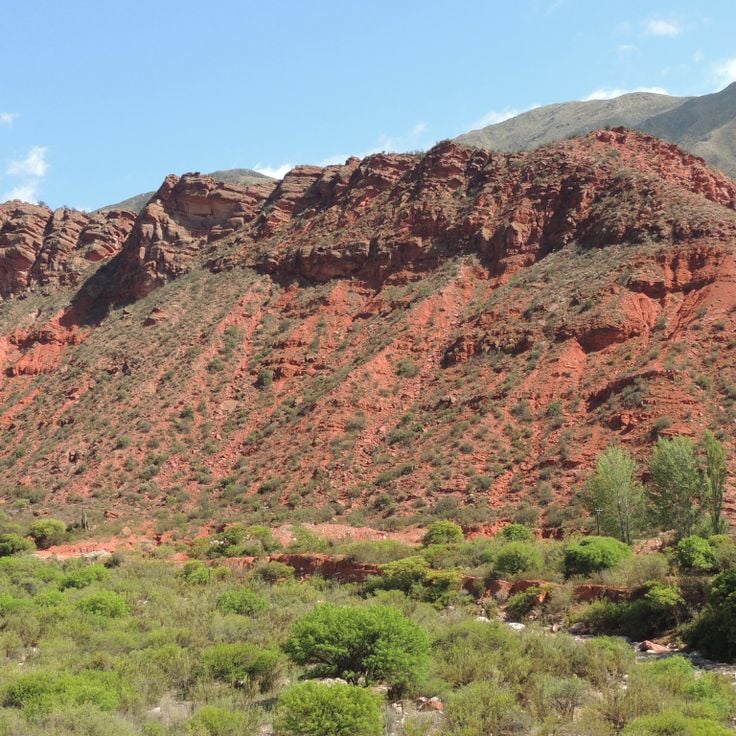
The Argentine landscape offers far more than its well-known urban centers. In the northwest, geological formations like Quebrada de las Conchas with its red sandstone cliffs and Talampaya National Park with its eroded canyons draw visitors. Quebrada de Humahuaca displays layers from millions of years of geological history, while Purmamarca sits at the base of the multicolored Cerro de los Siete Colores. Further north, Antofagasta de la Sierra allows access to high-altitude deserts and salt lakes.
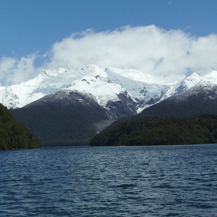
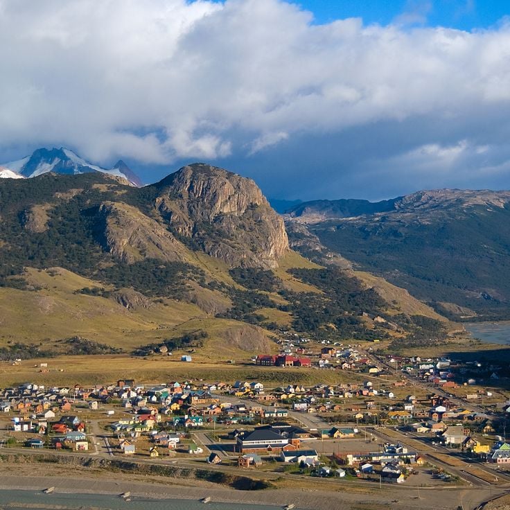
The Andes shape western Argentina with varied landscapes. The Uspallata Valley serves as a passage between Mendoza and Chile. In Patagonia, the granite spires of Monte Fitz Roy rise above glaciated valleys, while Los Alerces National Park protects ancient alerce trees and crystalline lakes. Villa Traful and Nahuel Huapi National Park show the Patagonian lake district with forested shores and volcanic peaks.
Archaeological sites and nature reserves complete these remote destinations. Cueva de las Manos preserves prehistoric rock art from more than 9,000 years ago. The Ruinas de Quilmes mark a pre-Columbian settlement in the Andes. Bosques Petrificados de Jaramillo contains fossilized araucaria trees from the Jurassic period. The Esteros del Iberá form one of South America's largest wetlands, home to caimans, capybaras and over 350 bird species. La Cumbrecita offers hiking trails through alpine forests in the Sierras de Córdoba, while Gaiman preserves the Welsh colonial history of Patagonia.
Argentina reveals beyond Buenos Aires, its capital, a world of canyons with red rock walls, granite mountains, and wetlands where caimans and capybaras live.
The Argentine landscape offers far more than its well-known urban centers. In the northwest, geological formations like Quebrada de las Conchas with its red sandstone cliffs and Talampaya National Park with its eroded canyons draw visitors. Quebrada de Humahuaca displays layers from millions of years of geological history, while Purmamarca sits at the base of the multicolored Cerro de los Siete Colores. Further north, Antofagasta de la Sierra allows access to high-altitude deserts and salt lakes.
The Andes shape western Argentina with varied landscapes. The Uspallata Valley serves as a passage between Mendoza and Chile. In Patagonia, the granite spires of Monte Fitz Roy rise above glaciated valleys, while Los Alerces National Park protects ancient alerce trees and crystalline lakes. Villa Traful and Nahuel Huapi National Park show the Patagonian lake district with forested shores and volcanic peaks.
Archaeological sites and nature reserves complete these remote destinations. Cueva de las Manos preserves prehistoric rock art from more than 9,000 years ago. The Ruinas de Quilmes mark a pre-Columbian settlement in the Andes. Bosques Petrificados de Jaramillo contains fossilized araucaria trees from the Jurassic period. The Esteros del Iberá form one of South America's largest wetlands, home to caimans, capybaras and over 350 bird species. La Cumbrecita offers hiking trails through alpine forests in the Sierras de Córdoba, while Gaiman preserves the Welsh colonial history of Patagonia.
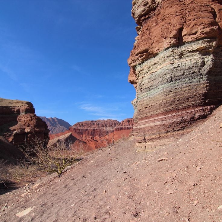
This canyon in northwestern Argentina displays geological layers of red and orange sandstone that document different periods of Earth's history. The formations developed through erosion and tectonic activity over millions of years. The road through Quebrada de las Conchas passes freestanding rock formations, including structures named El Anfiteatro and La Garganta del Diablo based on their shapes. The contrast between the rock colors and sparse vegetation demonstrates the geological diversity of the Argentine landscape.
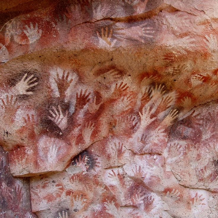
This cave in Argentina's remote locations collection holds over 800 prehistoric hand prints painted on rock walls by hunters and gatherers between approximately 9,000 and 13,000 years ago. The images show red, black and ochre negative handprints, along with depictions of guanacos and geometric patterns. Cueva de las Manos sits in an isolated canyon of the Río Pinturas and ranks among the major archaeological sites of Patagonia. The paintings record the cultural practices of the region's early inhabitants and can be reached via a marked trail from the Cañadón del Río Pinturas.
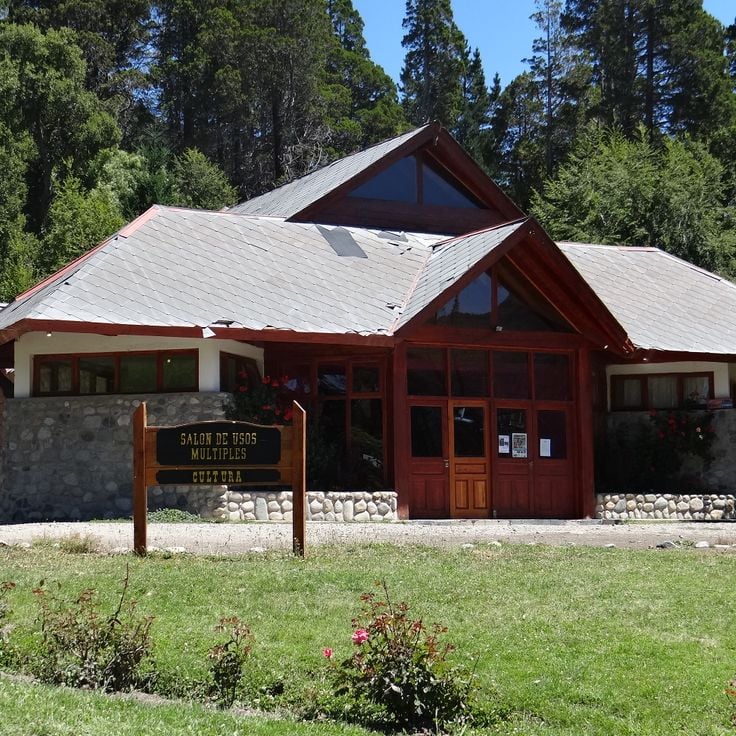
La Cumbrecita is a mountain village in the Sierras Grandes of Córdoba province at about 4,760 feet (1,450 meters) elevation. The village shows the influence of German settlers in its stone houses with wooden balconies. Motor vehicles are not allowed in the village center, so visitors park outside and walk to their accommodations. Hiking trails lead through araucaria forests to waterfalls and lookout points. The village sits in an isolated mountain region of Argentina and serves as a base for exploring the surrounding valleys and rock formations.
Bosques Petrificados de Jaramillo protects fossilized tree trunks and remains across the Patagonian steppe of Santa Cruz, part of Argentina's remote destinations. The petrified araucarias reach lengths of up to 30 meters (100 feet) and date from the Jurassic period, when this region was covered by tropical forests. Along with the stone trees, the park contains fossils of snails, clams and small mammals. The windswept terrain, scattered with rock fragments, reveals how geological processes transformed organic material into stone over millions of years. A walking trail leads through the fossil fields to the most significant sites.
Laguna Brava sits at 14,000 feet (4,200 m) above sea level in the remote Andes of La Rioja. This salt lake is surrounded by volcanic peaks rising above 19,700 feet (6,000 m). The mineral-rich water supports algae that flamingos and Andean gulls feed on, giving the birds their characteristic pink color. The road to the lake is only passable during the dry months and requires a four-wheel-drive vehicle.
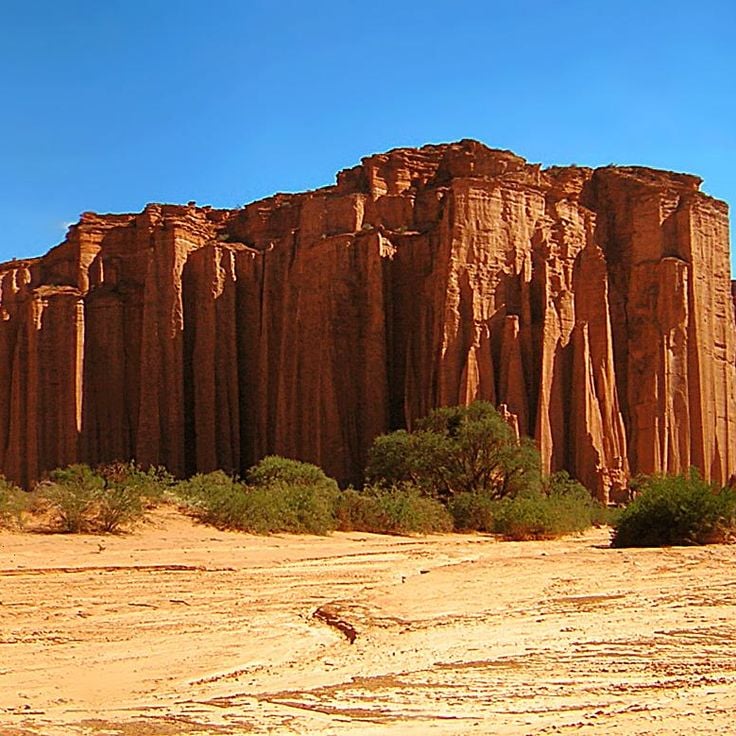
Talampaya National Park is among Argentina's most remote locations and displays a red sandstone canyon rising about 150 meters high. The park preserves fossils from the Triassic period and sits in a region where geological formations tell stories spanning millions of years. Visitors explore the canyon on foot and by vehicle, with the red rock walls revealing petroglyphs and prehistoric remains that record early human settlement.
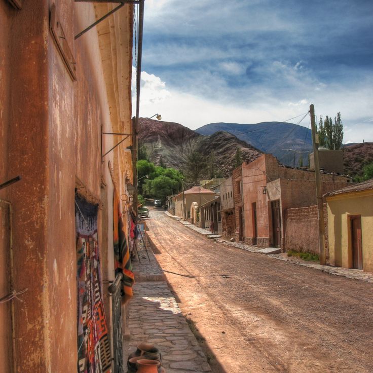
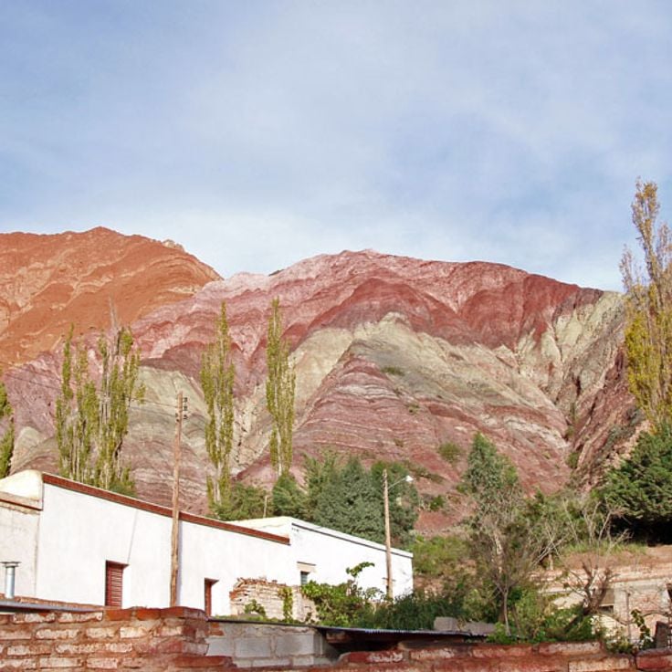
Purmamarca is one of the remote destinations in Argentina, showing the varied landscapes of the Andean highlands. This village sits at the base of Cerro de los Siete Colores, a mountain with layered sedimentary rock displaying bands of red, yellow and ochre from different minerals. Purmamarca was founded in the late 16th century and keeps its traditional architecture of adobe houses and a colonial church from 1648. The central square is surrounded by carob trees that provide shade for the local craft market. The village sits at 7,628 feet (2,324 meters) above sea level and serves as a base for exploring the Quebrada de Humahuaca, a canyon with pre-Columbian settlement sites. Narrow streets lead to small restaurants serving regional dishes like locro and tamales.
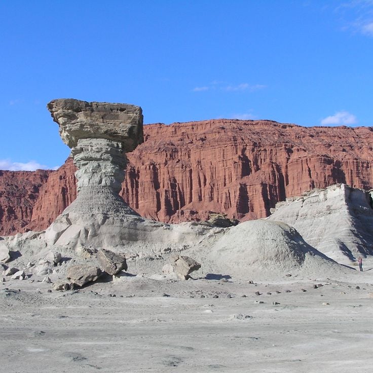
Valle de la Luna is a protected desert landscape in the San Juan mountains. This location preserves an exceptional paleontological site where sediments from the Triassic Period reveal fossils of dinosaurs and early mammals. The valley displays red rock cliffs and eroded formations shaped by wind and water over millions of years, giving visitors a direct view of ancient geological layers and the evolution of life in this region.
The Los Alerces National Park protects old alerce trees, which are among the oldest living things in Argentina, more than 3000 years old. The mountain landscape has glacier lakes like Lago Verde and Lago Futalaufquen, surrounded by southern beech forests and Patagonian cypresses. Andean condors fly over the valleys while pudús and huemuls live in the woods. The paths wind through thick plants to viewpoints overlooking snowy peaks and turquoise waters.
The Uspallata Valley serves in this collection as an example of Argentina's diverse Andean landscapes. This valley sits at about 1,900 meters elevation between the main Andes range and the Precordillera and was historically a vital link between Chile and Argentina along ancient Inca trails. The mountain flanks display distinct layers of red and green rock, shaped by volcanic activity and erosion. Archaeological sites document pre-Columbian settlement. The route connects Mendoza with the Chilean border today, passing through arid highland terrain with scattered vegetation.
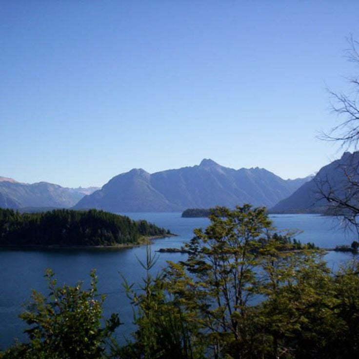
Villa Traful is a small settlement on the shore of its namesake lake in northern Patagonia, home to about 400 residents. Forests of arrayán and coihue trees surround the area, and the lake is known for trout and salmon fishing. Hiking trails lead through native vegetation, offering access to the natural landscape beyond the village. The community developed in the mid-20th century and has kept its low population density. Walking through Villa Traful, you notice a quiet pace of life shaped by the lake and mountains nearby.
This valley in the Argentine Andes extends for 96 miles (155 kilometers) and displays multicolored rock formations created by millions of years of geological processes. Quebrada de Humahuaca contains archaeological remains of pre-Columbian settlements and served as an important trade route between the Altiplano and the eastern plains. The rock walls show layers of red, yellow, green and ochre tones. Several historic villages lie along the valley, including Purmamarca, Tilcara and Humahuaca, where colonial-era churches and reconstructed fortifications stand. UNESCO has recognized this area as a World Heritage Site.
This national park stretches across the mountainous terrain of northern Patagonia along the Andean range. Here you find glacier lakes with deep blue waters nestled between steep mountain slopes. Volcanic mountain formations and forests of araucaria and southern beech trees characterize the landscape. Nahuel Huapi is the oldest protected area in Argentina and serves as a base for hikers exploring the valleys and mountain ridges of the region.
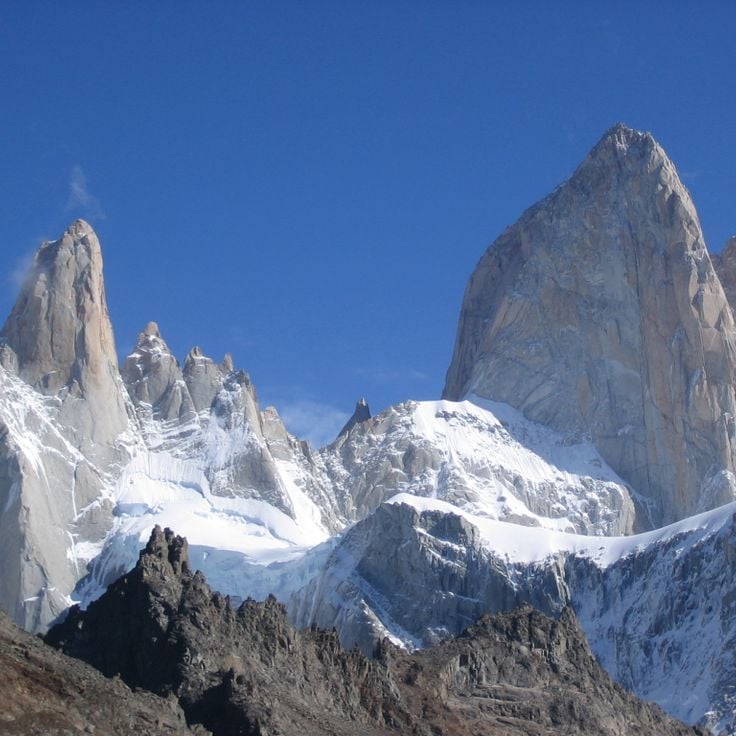
Monte Fitz Roy is a granite peak on the Argentina-Chile border that defines the remote Patagonian mountain region. This mountain draws experienced climbers with technically demanding routes on its steep rock faces. The first ascent took place in 1952. Monte Fitz Roy sits within Los Glaciares National Park, surrounded by glaciers and turquoise mountain lakes, and serves as a starting point for multiday treks through the windswept Patagonian landscape.
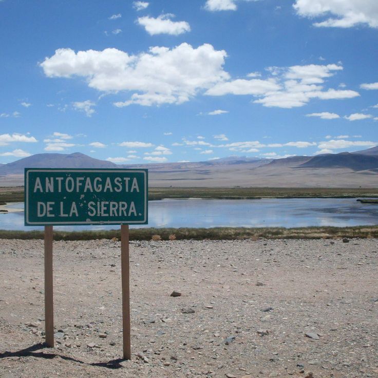
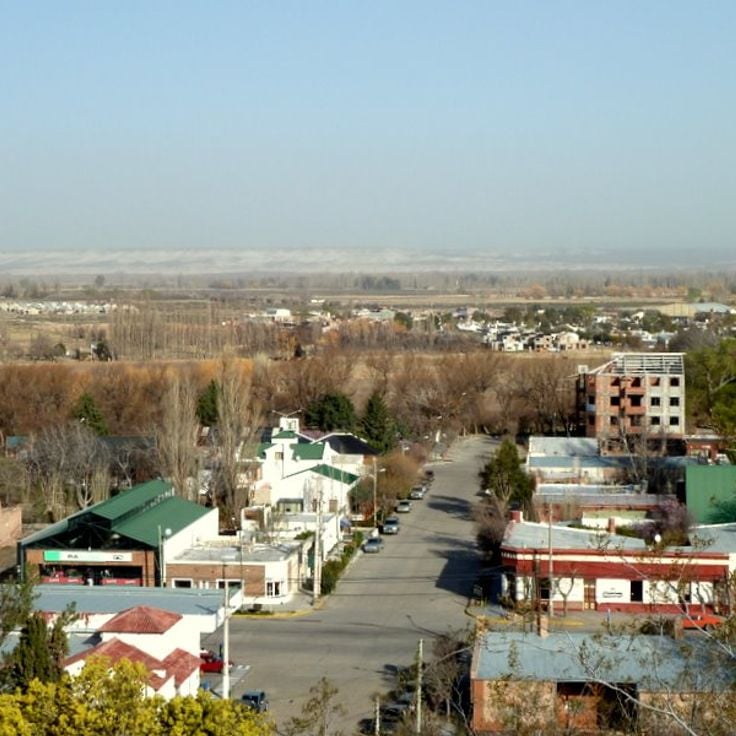
Antofagasta de la Sierra sits at roughly 3,400 meters (about 11,200 feet) on the Puna plateau in the Catamarca province. It works as a base for exploring the surrounding salt lakes, volcanoes, and the ruins of pre-Columbian settlements scattered across the high desert. The air is thin and dry, and the mineral-rich lakes nearby change color depending on the light and the season. The Laguna Blanca reserve, a short distance away, is a breeding ground for flamingos and one of the more remote natural sites in northwestern Argentina.
Gaiman preserves the traditions of its Welsh founders in this remote Patagonian location. The town was established in 1874 when immigrants from Wales arrived seeking religious freedom and farmland. Tea houses here serve Welsh specialties made from original recipes, including fruit cake and layered cake. The regional museum tells the story of the immigrants through photographs and farming implements. Gaiman sits in the Chubut Valley and serves as a gateway to exploring the remote regions of Patagonia.
The Ruinas de Quilmes is a pre-Columbian settlement on a mountain slope in Tucumán Province. It was inhabited from the 9th century until the Spanish conquest in the 17th century. The ruins spread across about 30 hectares (75 acres) and show the remains of homes, terraces and defensive structures built by the Quilmes people, who lived in this mountain region. The site reveals how a community developed and organized itself over several hundred years in this landscape. An archaeological museum at the site shares information about the history and daily life of those who lived here.
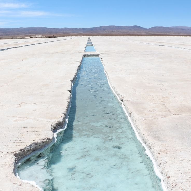
This vast salt flat lies at 12,000 feet in the Andes between Jujuy and Catamarca provinces. The white expanse of crystallized salt stretches across the high-altitude plateau, surrounded by peaks and volcanic formations. The landscape offers strong visual contrasts, with the brilliant white of the salt against the darker rock and sparse vegetation. Local communities have harvested salt here for generations using traditional methods. The site is accessible by vehicle, though road conditions depend on the season.
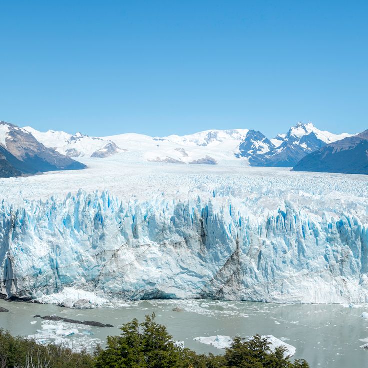
Perito Moreno Glacier in this remote corner of Argentina sits in Los Glaciares National Park. Unlike most glaciers worldwide, this one continues to advance, occasionally damming Lake Argentino and creating dramatic calving events where massive ice blocks break away and crash into the water. Visitors can watch the glacier from viewing platforms or take boat tours that bring you closer to the ice. The surrounding landscape shows how glacial ice, meltwater and mountain terrain interact.
This peninsula in Chubut juts into the Atlantic Ocean and forms a protected area for marine mammals. Southern right whales migrate here to breed and nurse calves between June and December. Orca pods hunt sea lions along the beaches. Elephant seals haul out on remote shores, and penguins nest in burrows across the terrain. The peninsula's beaches and cliffs provide viewpoints for observing wildlife. The landscape consists of windswept grasslands with minimal vegetation, and visitors drive between various wildlife colonies.
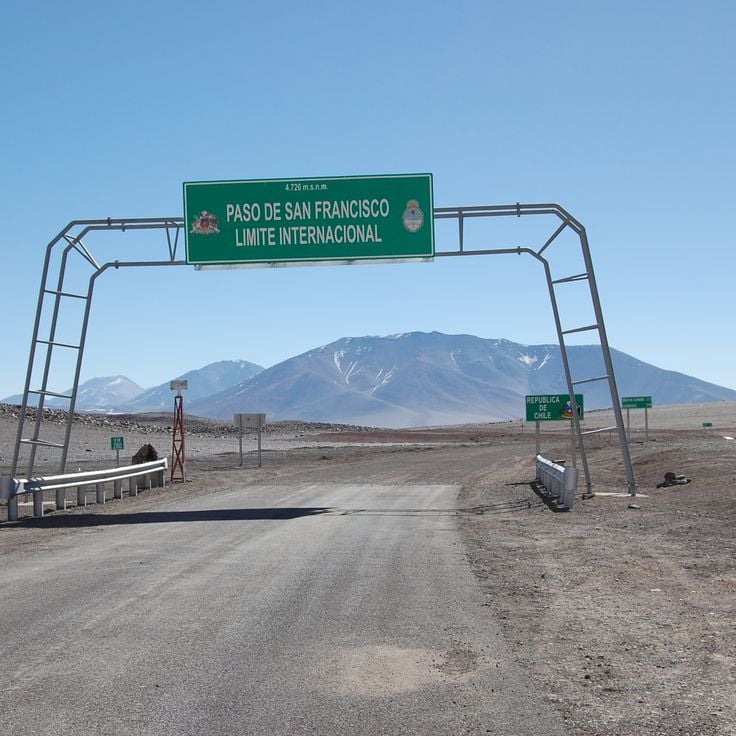
The Paso de San Francisco sits in the high Andes of Catamarca province, crossing the border between Argentina and Chile at 4,850 feet (4,850 m) above sea level. It connects the high plateau of the puna with the Chilean side of the Atacama desert region. The land around the pass is dry and bare, with sparse low vegetation, volcanic peaks in the distance, and a raw quality to the light that is most noticeable in the early morning hours. A four-wheel drive vehicle is required to travel this road.
This mountain pass in La Rioja descends from high desert plateaus toward lower river valleys with sharp switchbacks carved into the hillside. The road itself becomes a feature of the landscape, offering views across successive valleys and layered rock formations. The geological transitions visible from the pass show how elevation and climate create different ecosystems. The descent reveals changes from sparse high-altitude vegetation to more abundant growth in lower zones. Cuesta de Miranda stands as one of Argentina's remote locations, where the landscape reveals millions of years of geological history.
El Chaltén is a hiking destination in Santa Cruz that sits in the shadow of granite peaks including Mount Fitz Roy and Cerro Torre. The small village serves as a base for day hikes and multiday treks through the mountainous terrain. Trails lead through southern beech forests to viewpoints overlooking glacial valleys and turquoise lakes. The surrounding landscape shows the continuous reshaping of mountains by glacial ice and water erosion. Weather changes rapidly in the region, with clear mornings often followed by afternoon clouds.
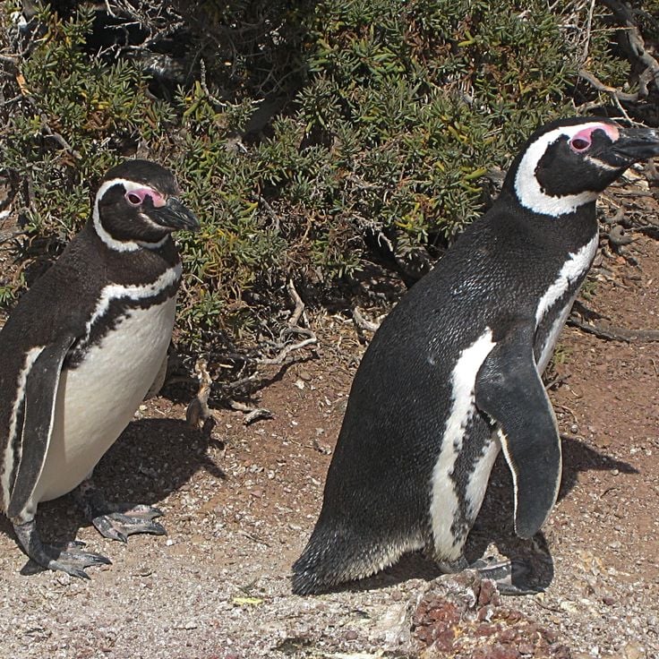
This reserve on the Chubut coast protects the largest Magellanic penguin colony in Argentina. Up to 2 million penguins nest in burrows across the reserve during breeding season, from September through April. Visitors walk among the nesting birds and observe their behavior, vocalizations and interactions. The reserve also provides habitat for other seabirds including cormorants and terns. The rocky shoreline offers views of the Atlantic Ocean and access to observe marine ecosystems.
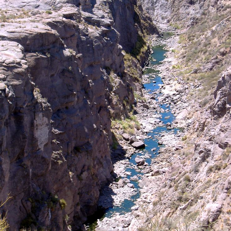
The Cañón del Atuel in Mendoza displays layered rock formations colored red, orange and purple, carved by the Río Atuel over millions of years. The canyon walls rise steeply from the river valley, creating a landscape of rock pillars and eroded formations. The contrast between the colorful rocks and the flowing river shows the geological processes that continue to shape the terrain. Visitors can explore the canyon by vehicle and on foot, accessing viewpoints from various elevations. It represents one of Argentina's remote locations, where the landscape extends far beyond the well-known urban centers.
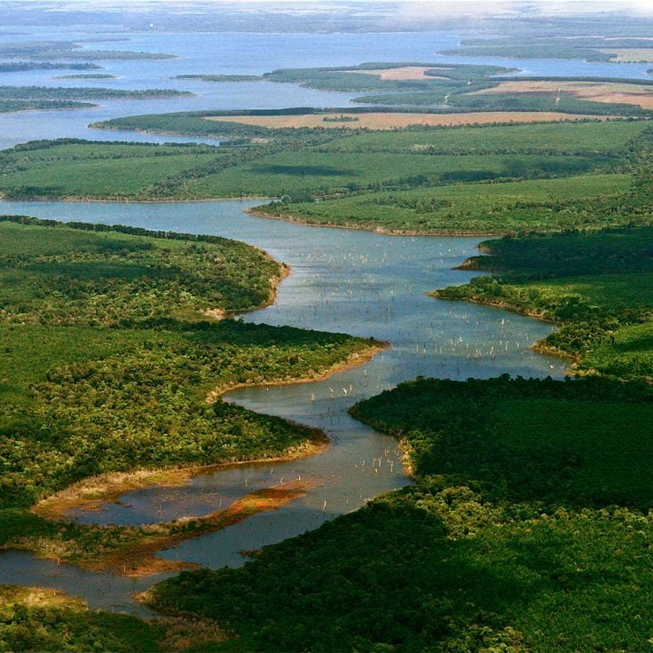
Within this collection of remote Argentine destinations, the Esteros del Iberá form a vast wetland system in northeastern Argentina, covering much of Corrientes Province. This freshwater landscape consists of shallow lagoons, floating islands and flooded grasslands. The area provides habitat for caimans, capybaras and more than 350 bird species. Visitors can explore the wetlands by boat and observe wildlife at close range. The Esteros del Iberá rank among Argentina's most important conservation areas and represent one of the largest wetland ecosystems in South America.
This canyon in northwestern Argentina displays geological layers of red and orange sandstone that document different periods of Earth's history. The formations developed through erosion and tectonic activity over millions of years. The road through Quebrada de las Conchas passes freestanding rock formations, including structures named El Anfiteatro and La Garganta del Diablo based on their shapes. The contrast between the rock colors and sparse vegetation demonstrates the geological diversity of the Argentine landscape.
This cave in Argentina's remote locations collection holds over 800 prehistoric hand prints painted on rock walls by hunters and gatherers between approximately 9,000 and 13,000 years ago. The images show red, black and ochre negative handprints, along with depictions of guanacos and geometric patterns. Cueva de las Manos sits in an isolated canyon of the Río Pinturas and ranks among the major archaeological sites of Patagonia. The paintings record the cultural practices of the region's early inhabitants and can be reached via a marked trail from the Cañadón del Río Pinturas.
La Cumbrecita is a mountain village in the Sierras Grandes of Córdoba province at about 4,760 feet (1,450 meters) elevation. The village shows the influence of German settlers in its stone houses with wooden balconies. Motor vehicles are not allowed in the village center, so visitors park outside and walk to their accommodations. Hiking trails lead through araucaria forests to waterfalls and lookout points. The village sits in an isolated mountain region of Argentina and serves as a base for exploring the surrounding valleys and rock formations.
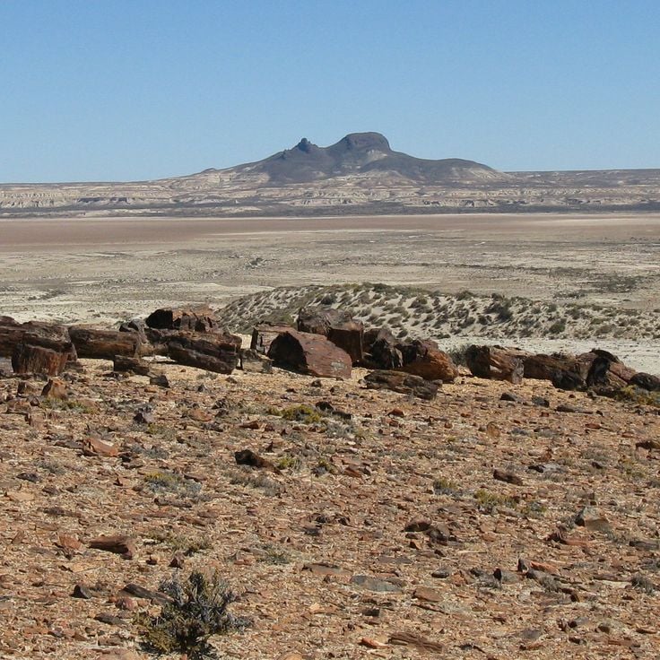
Bosques Petrificados de Jaramillo protects fossilized tree trunks and remains across the Patagonian steppe of Santa Cruz, part of Argentina's remote destinations. The petrified araucarias reach lengths of up to 30 meters (100 feet) and date from the Jurassic period, when this region was covered by tropical forests. Along with the stone trees, the park contains fossils of snails, clams and small mammals. The windswept terrain, scattered with rock fragments, reveals how geological processes transformed organic material into stone over millions of years. A walking trail leads through the fossil fields to the most significant sites.
Laguna Brava sits at 14,000 feet (4,200 m) above sea level in the remote Andes of La Rioja. This salt lake is surrounded by volcanic peaks rising above 19,700 feet (6,000 m). The mineral-rich water supports algae that flamingos and Andean gulls feed on, giving the birds their characteristic pink color. The road to the lake is only passable during the dry months and requires a four-wheel-drive vehicle.
Talampaya National Park is among Argentina's most remote locations and displays a red sandstone canyon rising about 150 meters high. The park preserves fossils from the Triassic period and sits in a region where geological formations tell stories spanning millions of years. Visitors explore the canyon on foot and by vehicle, with the red rock walls revealing petroglyphs and prehistoric remains that record early human settlement.
Purmamarca is one of the remote destinations in Argentina, showing the varied landscapes of the Andean highlands. This village sits at the base of Cerro de los Siete Colores, a mountain with layered sedimentary rock displaying bands of red, yellow and ochre from different minerals. Purmamarca was founded in the late 16th century and keeps its traditional architecture of adobe houses and a colonial church from 1648. The central square is surrounded by carob trees that provide shade for the local craft market. The village sits at 7,628 feet (2,324 meters) above sea level and serves as a base for exploring the Quebrada de Humahuaca, a canyon with pre-Columbian settlement sites. Narrow streets lead to small restaurants serving regional dishes like locro and tamales.
Valle de la Luna is a protected desert landscape in the San Juan mountains. This location preserves an exceptional paleontological site where sediments from the Triassic Period reveal fossils of dinosaurs and early mammals. The valley displays red rock cliffs and eroded formations shaped by wind and water over millions of years, giving visitors a direct view of ancient geological layers and the evolution of life in this region.
The Los Alerces National Park protects old alerce trees, which are among the oldest living things in Argentina, more than 3000 years old. The mountain landscape has glacier lakes like Lago Verde and Lago Futalaufquen, surrounded by southern beech forests and Patagonian cypresses. Andean condors fly over the valleys while pudús and huemuls live in the woods. The paths wind through thick plants to viewpoints overlooking snowy peaks and turquoise waters.
The Uspallata Valley serves in this collection as an example of Argentina's diverse Andean landscapes. This valley sits at about 1,900 meters elevation between the main Andes range and the Precordillera and was historically a vital link between Chile and Argentina along ancient Inca trails. The mountain flanks display distinct layers of red and green rock, shaped by volcanic activity and erosion. Archaeological sites document pre-Columbian settlement. The route connects Mendoza with the Chilean border today, passing through arid highland terrain with scattered vegetation.
Villa Traful is a small settlement on the shore of its namesake lake in northern Patagonia, home to about 400 residents. Forests of arrayán and coihue trees surround the area, and the lake is known for trout and salmon fishing. Hiking trails lead through native vegetation, offering access to the natural landscape beyond the village. The community developed in the mid-20th century and has kept its low population density. Walking through Villa Traful, you notice a quiet pace of life shaped by the lake and mountains nearby.
This valley in the Argentine Andes extends for 96 miles (155 kilometers) and displays multicolored rock formations created by millions of years of geological processes. Quebrada de Humahuaca contains archaeological remains of pre-Columbian settlements and served as an important trade route between the Altiplano and the eastern plains. The rock walls show layers of red, yellow, green and ochre tones. Several historic villages lie along the valley, including Purmamarca, Tilcara and Humahuaca, where colonial-era churches and reconstructed fortifications stand. UNESCO has recognized this area as a World Heritage Site.
This national park stretches across the mountainous terrain of northern Patagonia along the Andean range. Here you find glacier lakes with deep blue waters nestled between steep mountain slopes. Volcanic mountain formations and forests of araucaria and southern beech trees characterize the landscape. Nahuel Huapi is the oldest protected area in Argentina and serves as a base for hikers exploring the valleys and mountain ridges of the region.
Monte Fitz Roy is a granite peak on the Argentina-Chile border that defines the remote Patagonian mountain region. This mountain draws experienced climbers with technically demanding routes on its steep rock faces. The first ascent took place in 1952. Monte Fitz Roy sits within Los Glaciares National Park, surrounded by glaciers and turquoise mountain lakes, and serves as a starting point for multiday treks through the windswept Patagonian landscape.
Antofagasta de la Sierra sits at roughly 3,400 meters (about 11,200 feet) on the Puna plateau in the Catamarca province. It works as a base for exploring the surrounding salt lakes, volcanoes, and the ruins of pre-Columbian settlements scattered across the high desert. The air is thin and dry, and the mineral-rich lakes nearby change color depending on the light and the season. The Laguna Blanca reserve, a short distance away, is a breeding ground for flamingos and one of the more remote natural sites in northwestern Argentina.
Gaiman preserves the traditions of its Welsh founders in this remote Patagonian location. The town was established in 1874 when immigrants from Wales arrived seeking religious freedom and farmland. Tea houses here serve Welsh specialties made from original recipes, including fruit cake and layered cake. The regional museum tells the story of the immigrants through photographs and farming implements. Gaiman sits in the Chubut Valley and serves as a gateway to exploring the remote regions of Patagonia.
The Ruinas de Quilmes is a pre-Columbian settlement on a mountain slope in Tucumán Province. It was inhabited from the 9th century until the Spanish conquest in the 17th century. The ruins spread across about 30 hectares (75 acres) and show the remains of homes, terraces and defensive structures built by the Quilmes people, who lived in this mountain region. The site reveals how a community developed and organized itself over several hundred years in this landscape. An archaeological museum at the site shares information about the history and daily life of those who lived here.
This vast salt flat lies at 12,000 feet in the Andes between Jujuy and Catamarca provinces. The white expanse of crystallized salt stretches across the high-altitude plateau, surrounded by peaks and volcanic formations. The landscape offers strong visual contrasts, with the brilliant white of the salt against the darker rock and sparse vegetation. Local communities have harvested salt here for generations using traditional methods. The site is accessible by vehicle, though road conditions depend on the season.
Perito Moreno Glacier in this remote corner of Argentina sits in Los Glaciares National Park. Unlike most glaciers worldwide, this one continues to advance, occasionally damming Lake Argentino and creating dramatic calving events where massive ice blocks break away and crash into the water. Visitors can watch the glacier from viewing platforms or take boat tours that bring you closer to the ice. The surrounding landscape shows how glacial ice, meltwater and mountain terrain interact.
This peninsula in Chubut juts into the Atlantic Ocean and forms a protected area for marine mammals. Southern right whales migrate here to breed and nurse calves between June and December. Orca pods hunt sea lions along the beaches. Elephant seals haul out on remote shores, and penguins nest in burrows across the terrain. The peninsula's beaches and cliffs provide viewpoints for observing wildlife. The landscape consists of windswept grasslands with minimal vegetation, and visitors drive between various wildlife colonies.
The Paso de San Francisco sits in the high Andes of Catamarca province, crossing the border between Argentina and Chile at 4,850 feet (4,850 m) above sea level. It connects the high plateau of the puna with the Chilean side of the Atacama desert region. The land around the pass is dry and bare, with sparse low vegetation, volcanic peaks in the distance, and a raw quality to the light that is most noticeable in the early morning hours. A four-wheel drive vehicle is required to travel this road.
This mountain pass in La Rioja descends from high desert plateaus toward lower river valleys with sharp switchbacks carved into the hillside. The road itself becomes a feature of the landscape, offering views across successive valleys and layered rock formations. The geological transitions visible from the pass show how elevation and climate create different ecosystems. The descent reveals changes from sparse high-altitude vegetation to more abundant growth in lower zones. Cuesta de Miranda stands as one of Argentina's remote locations, where the landscape reveals millions of years of geological history.
El Chaltén is a hiking destination in Santa Cruz that sits in the shadow of granite peaks including Mount Fitz Roy and Cerro Torre. The small village serves as a base for day hikes and multiday treks through the mountainous terrain. Trails lead through southern beech forests to viewpoints overlooking glacial valleys and turquoise lakes. The surrounding landscape shows the continuous reshaping of mountains by glacial ice and water erosion. Weather changes rapidly in the region, with clear mornings often followed by afternoon clouds.
This reserve on the Chubut coast protects the largest Magellanic penguin colony in Argentina. Up to 2 million penguins nest in burrows across the reserve during breeding season, from September through April. Visitors walk among the nesting birds and observe their behavior, vocalizations and interactions. The reserve also provides habitat for other seabirds including cormorants and terns. The rocky shoreline offers views of the Atlantic Ocean and access to observe marine ecosystems.
The Cañón del Atuel in Mendoza displays layered rock formations colored red, orange and purple, carved by the Río Atuel over millions of years. The canyon walls rise steeply from the river valley, creating a landscape of rock pillars and eroded formations. The contrast between the colorful rocks and the flowing river shows the geological processes that continue to shape the terrain. Visitors can explore the canyon by vehicle and on foot, accessing viewpoints from various elevations. It represents one of Argentina's remote locations, where the landscape extends far beyond the well-known urban centers.
Within this collection of remote Argentine destinations, the Esteros del Iberá form a vast wetland system in northeastern Argentina, covering much of Corrientes Province. This freshwater landscape consists of shallow lagoons, floating islands and flooded grasslands. The area provides habitat for caimans, capybaras and more than 350 bird species. Visitors can explore the wetlands by boat and observe wildlife at close range. The Esteros del Iberá rank among Argentina's most important conservation areas and represent one of the largest wetland ecosystems in South America.
This canyon in northwestern Argentina displays geological layers of red and orange sandstone that document different periods of Earth's history. The formations developed through erosion and tectonic activity over millions of years. The road through Quebrada de las Conchas passes freestanding rock formations, including structures named El Anfiteatro and La Garganta del Diablo based on their shapes. The contrast between the rock colors and sparse vegetation demonstrates the geological diversity of the Argentine landscape.
This cave in Argentina's remote locations collection holds over 800 prehistoric hand prints painted on rock walls by hunters and gatherers between approximately 9,000 and 13,000 years ago. The images show red, black and ochre negative handprints, along with depictions of guanacos and geometric patterns. Cueva de las Manos sits in an isolated canyon of the Río Pinturas and ranks among the major archaeological sites of Patagonia. The paintings record the cultural practices of the region's early inhabitants and can be reached via a marked trail from the Cañadón del Río Pinturas.
La Cumbrecita is a mountain village in the Sierras Grandes of Córdoba province at about 4,760 feet (1,450 meters) elevation. The village shows the influence of German settlers in its stone houses with wooden balconies. Motor vehicles are not allowed in the village center, so visitors park outside and walk to their accommodations. Hiking trails lead through araucaria forests to waterfalls and lookout points. The village sits in an isolated mountain region of Argentina and serves as a base for exploring the surrounding valleys and rock formations.
Bosques Petrificados de Jaramillo protects fossilized tree trunks and remains across the Patagonian steppe of Santa Cruz, part of Argentina's remote destinations. The petrified araucarias reach lengths of up to 30 meters (100 feet) and date from the Jurassic period, when this region was covered by tropical forests. Along with the stone trees, the park contains fossils of snails, clams and small mammals. The windswept terrain, scattered with rock fragments, reveals how geological processes transformed organic material into stone over millions of years. A walking trail leads through the fossil fields to the most significant sites.
Laguna Brava sits at 14,000 feet (4,200 m) above sea level in the remote Andes of La Rioja. This salt lake is surrounded by volcanic peaks rising above 19,700 feet (6,000 m). The mineral-rich water supports algae that flamingos and Andean gulls feed on, giving the birds their characteristic pink color. The road to the lake is only passable during the dry months and requires a four-wheel-drive vehicle.
Talampaya National Park is among Argentina's most remote locations and displays a red sandstone canyon rising about 150 meters high. The park preserves fossils from the Triassic period and sits in a region where geological formations tell stories spanning millions of years. Visitors explore the canyon on foot and by vehicle, with the red rock walls revealing petroglyphs and prehistoric remains that record early human settlement.
Purmamarca is one of the remote destinations in Argentina, showing the varied landscapes of the Andean highlands. This village sits at the base of Cerro de los Siete Colores, a mountain with layered sedimentary rock displaying bands of red, yellow and ochre from different minerals. Purmamarca was founded in the late 16th century and keeps its traditional architecture of adobe houses and a colonial church from 1648. The central square is surrounded by carob trees that provide shade for the local craft market. The village sits at 7,628 feet (2,324 meters) above sea level and serves as a base for exploring the Quebrada de Humahuaca, a canyon with pre-Columbian settlement sites. Narrow streets lead to small restaurants serving regional dishes like locro and tamales.
Valle de la Luna is a protected desert landscape in the San Juan mountains. This location preserves an exceptional paleontological site where sediments from the Triassic Period reveal fossils of dinosaurs and early mammals. The valley displays red rock cliffs and eroded formations shaped by wind and water over millions of years, giving visitors a direct view of ancient geological layers and the evolution of life in this region.
The Los Alerces National Park protects old alerce trees, which are among the oldest living things in Argentina, more than 3000 years old. The mountain landscape has glacier lakes like Lago Verde and Lago Futalaufquen, surrounded by southern beech forests and Patagonian cypresses. Andean condors fly over the valleys while pudús and huemuls live in the woods. The paths wind through thick plants to viewpoints overlooking snowy peaks and turquoise waters.
The Uspallata Valley serves in this collection as an example of Argentina's diverse Andean landscapes. This valley sits at about 1,900 meters elevation between the main Andes range and the Precordillera and was historically a vital link between Chile and Argentina along ancient Inca trails. The mountain flanks display distinct layers of red and green rock, shaped by volcanic activity and erosion. Archaeological sites document pre-Columbian settlement. The route connects Mendoza with the Chilean border today, passing through arid highland terrain with scattered vegetation.
Villa Traful is a small settlement on the shore of its namesake lake in northern Patagonia, home to about 400 residents. Forests of arrayán and coihue trees surround the area, and the lake is known for trout and salmon fishing. Hiking trails lead through native vegetation, offering access to the natural landscape beyond the village. The community developed in the mid-20th century and has kept its low population density. Walking through Villa Traful, you notice a quiet pace of life shaped by the lake and mountains nearby.
This valley in the Argentine Andes extends for 96 miles (155 kilometers) and displays multicolored rock formations created by millions of years of geological processes. Quebrada de Humahuaca contains archaeological remains of pre-Columbian settlements and served as an important trade route between the Altiplano and the eastern plains. The rock walls show layers of red, yellow, green and ochre tones. Several historic villages lie along the valley, including Purmamarca, Tilcara and Humahuaca, where colonial-era churches and reconstructed fortifications stand. UNESCO has recognized this area as a World Heritage Site.
This national park stretches across the mountainous terrain of northern Patagonia along the Andean range. Here you find glacier lakes with deep blue waters nestled between steep mountain slopes. Volcanic mountain formations and forests of araucaria and southern beech trees characterize the landscape. Nahuel Huapi is the oldest protected area in Argentina and serves as a base for hikers exploring the valleys and mountain ridges of the region.
Monte Fitz Roy is a granite peak on the Argentina-Chile border that defines the remote Patagonian mountain region. This mountain draws experienced climbers with technically demanding routes on its steep rock faces. The first ascent took place in 1952. Monte Fitz Roy sits within Los Glaciares National Park, surrounded by glaciers and turquoise mountain lakes, and serves as a starting point for multiday treks through the windswept Patagonian landscape.
Antofagasta de la Sierra sits at roughly 3,400 meters (about 11,200 feet) on the Puna plateau in the Catamarca province. It works as a base for exploring the surrounding salt lakes, volcanoes, and the ruins of pre-Columbian settlements scattered across the high desert. The air is thin and dry, and the mineral-rich lakes nearby change color depending on the light and the season. The Laguna Blanca reserve, a short distance away, is a breeding ground for flamingos and one of the more remote natural sites in northwestern Argentina.
Gaiman preserves the traditions of its Welsh founders in this remote Patagonian location. The town was established in 1874 when immigrants from Wales arrived seeking religious freedom and farmland. Tea houses here serve Welsh specialties made from original recipes, including fruit cake and layered cake. The regional museum tells the story of the immigrants through photographs and farming implements. Gaiman sits in the Chubut Valley and serves as a gateway to exploring the remote regions of Patagonia.
The Ruinas de Quilmes is a pre-Columbian settlement on a mountain slope in Tucumán Province. It was inhabited from the 9th century until the Spanish conquest in the 17th century. The ruins spread across about 30 hectares (75 acres) and show the remains of homes, terraces and defensive structures built by the Quilmes people, who lived in this mountain region. The site reveals how a community developed and organized itself over several hundred years in this landscape. An archaeological museum at the site shares information about the history and daily life of those who lived here.
This vast salt flat lies at 12,000 feet in the Andes between Jujuy and Catamarca provinces. The white expanse of crystallized salt stretches across the high-altitude plateau, surrounded by peaks and volcanic formations. The landscape offers strong visual contrasts, with the brilliant white of the salt against the darker rock and sparse vegetation. Local communities have harvested salt here for generations using traditional methods. The site is accessible by vehicle, though road conditions depend on the season.
Perito Moreno Glacier in this remote corner of Argentina sits in Los Glaciares National Park. Unlike most glaciers worldwide, this one continues to advance, occasionally damming Lake Argentino and creating dramatic calving events where massive ice blocks break away and crash into the water. Visitors can watch the glacier from viewing platforms or take boat tours that bring you closer to the ice. The surrounding landscape shows how glacial ice, meltwater and mountain terrain interact.
This peninsula in Chubut juts into the Atlantic Ocean and forms a protected area for marine mammals. Southern right whales migrate here to breed and nurse calves between June and December. Orca pods hunt sea lions along the beaches. Elephant seals haul out on remote shores, and penguins nest in burrows across the terrain. The peninsula's beaches and cliffs provide viewpoints for observing wildlife. The landscape consists of windswept grasslands with minimal vegetation, and visitors drive between various wildlife colonies.
The Paso de San Francisco sits in the high Andes of Catamarca province, crossing the border between Argentina and Chile at 4,850 feet (4,850 m) above sea level. It connects the high plateau of the puna with the Chilean side of the Atacama desert region. The land around the pass is dry and bare, with sparse low vegetation, volcanic peaks in the distance, and a raw quality to the light that is most noticeable in the early morning hours. A four-wheel drive vehicle is required to travel this road.
This mountain pass in La Rioja descends from high desert plateaus toward lower river valleys with sharp switchbacks carved into the hillside. The road itself becomes a feature of the landscape, offering views across successive valleys and layered rock formations. The geological transitions visible from the pass show how elevation and climate create different ecosystems. The descent reveals changes from sparse high-altitude vegetation to more abundant growth in lower zones. Cuesta de Miranda stands as one of Argentina's remote locations, where the landscape reveals millions of years of geological history.
El Chaltén is a hiking destination in Santa Cruz that sits in the shadow of granite peaks including Mount Fitz Roy and Cerro Torre. The small village serves as a base for day hikes and multiday treks through the mountainous terrain. Trails lead through southern beech forests to viewpoints overlooking glacial valleys and turquoise lakes. The surrounding landscape shows the continuous reshaping of mountains by glacial ice and water erosion. Weather changes rapidly in the region, with clear mornings often followed by afternoon clouds.
This reserve on the Chubut coast protects the largest Magellanic penguin colony in Argentina. Up to 2 million penguins nest in burrows across the reserve during breeding season, from September through April. Visitors walk among the nesting birds and observe their behavior, vocalizations and interactions. The reserve also provides habitat for other seabirds including cormorants and terns. The rocky shoreline offers views of the Atlantic Ocean and access to observe marine ecosystems.
The Cañón del Atuel in Mendoza displays layered rock formations colored red, orange and purple, carved by the Río Atuel over millions of years. The canyon walls rise steeply from the river valley, creating a landscape of rock pillars and eroded formations. The contrast between the colorful rocks and the flowing river shows the geological processes that continue to shape the terrain. Visitors can explore the canyon by vehicle and on foot, accessing viewpoints from various elevations. It represents one of Argentina's remote locations, where the landscape extends far beyond the well-known urban centers.
Within this collection of remote Argentine destinations, the Esteros del Iberá form a vast wetland system in northeastern Argentina, covering much of Corrientes Province. This freshwater landscape consists of shallow lagoons, floating islands and flooded grasslands. The area provides habitat for caimans, capybaras and more than 350 bird species. Visitors can explore the wetlands by boat and observe wildlife at close range. The Esteros del Iberá rank among Argentina's most important conservation areas and represent one of the largest wetland ecosystems in South America.
If you are now truly ready to explore this hidden Argentina, prepare for long trips and often on unpaved roads. The best times are autumn and spring when the weather is steady. Bring plenty of water, especially in desert areas and at high altitudes, where dry air can surprise even experienced travelers.