See the monuments around you in AROpen chests in the app
Around Us is built for your phone — point your camera at the streets and discover the monuments and places around you in augmented reality.Around Us is built for your phone — chests unlock when you walk, explore and capture nearby places.
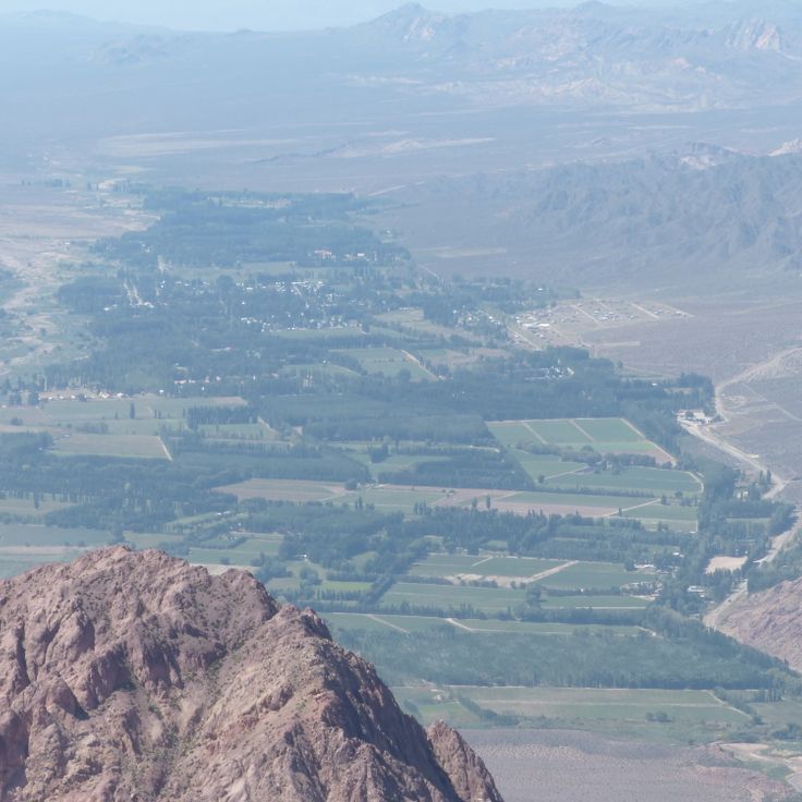
Argentina extends across multiple climate zones and contains numerous geological formations. The country encompasses high mountain ranges in the Andes, salt flats in the northwest, rock formations in Patagonia, and extensive grasslands. These areas display the region's geological history and the adaptation of human settlements to different environments.
The sites include volcanic craters, thermal springs, canyons, and historic villages. Many of these locations lie away from main routes and require several hours of travel. The regions document pre-Columbian cultures, colonial history, and traditional ways of life that continue today.
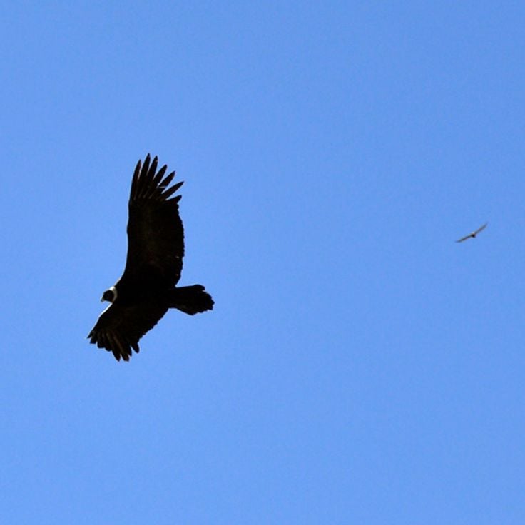
Quebrada de los Condores is a canyon located in La Rioja province, characterized by steep rock walls and its importance as a habitat for Andean condors. Visitors can observe these large raptors during their flight maneuvers along the cliffs, particularly in the morning hours when thermal updrafts facilitate soaring. The canyon extends through arid terrain with vegetation typical of the Argentine Andes and provides several viewpoints for bird watching.
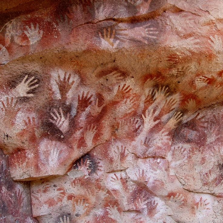
Cueva de las Manos is an archaeological site located in the valley of the Río Pinturas. This cave preserves over 800 hand prints and depictions of hunting scenes created approximately 13,000 years ago by prehistoric hunter-gatherer communities. The rock art features predominantly left hands rendered in red ochre, along with representations of guanacos and geometric patterns.
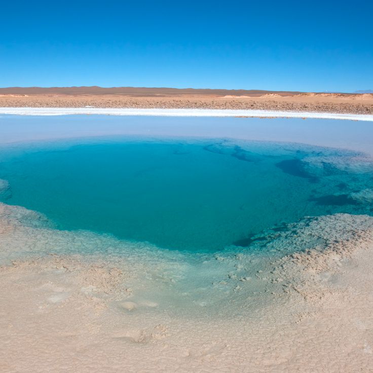
Ojo de Mar is a natural water basin located in the salt desert of Salta province. Underground springs continuously feed this body of water with mineral-rich content. The exceptional clarity of the water allows visibility of mineral deposits on the basin floor. This geological formation resulted from the interaction between groundwater flows and the surrounding salt-rich environment.
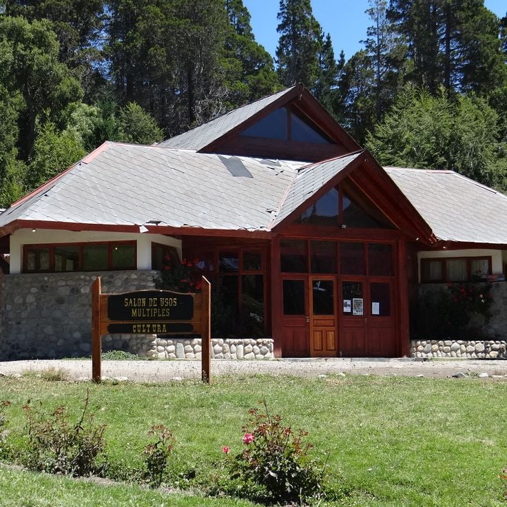
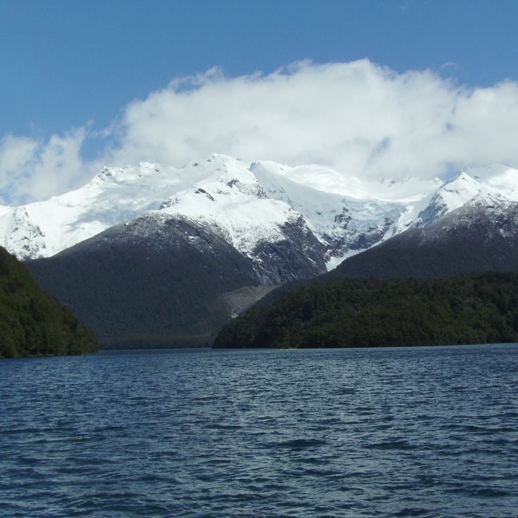
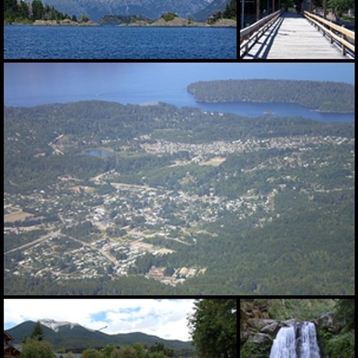
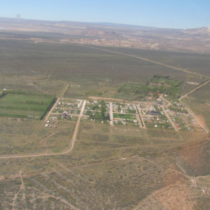
Villa Traful is a small village of approximately 400 inhabitants located on the shore of Lake Traful in the northern Patagonian province of Neuquén. The village sits nestled between forested slopes and mountains within Nahuel Huapi National Park. The lake provides opportunities for diving, kayaking, and fishing. Hiking trails lead through lenga and ñire forests to viewpoints and waterfalls. The area receives considerably fewer visitors than the nearby tourist centers of San Martín de los Andes and Bariloche.
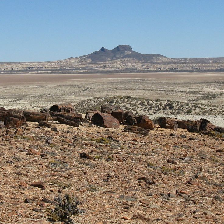
The Jaramillo Geological Preserve spans 15,000 hectares in Santa Cruz Province and protects one of the most significant petrified araucaria forests from the Jurassic period. The fossilized trees formed approximately 150 million years ago when volcanic activity buried the forest under layers of ash. The specimens preserve details of the wood structure and reach diameters of up to 3 meters. The preserve occupies a semi-arid plateau and documents the prehistoric flora of Patagonia.
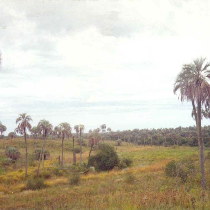
El Palmar National Park covers 8,500 hectares in eastern Argentina and protects one of the last major stands of Yatay palms. This palm species defines the park's landscape, forming open savannas. The park is home to armadillos, rheas, and over 200 bird species, including various parrots and raptors. Walking trails lead through the palm groves and along the Uruguay River. The region provides opportunities for wildlife observation, particularly during early morning and evening hours.
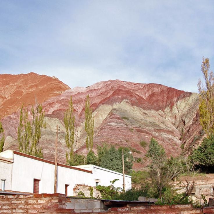
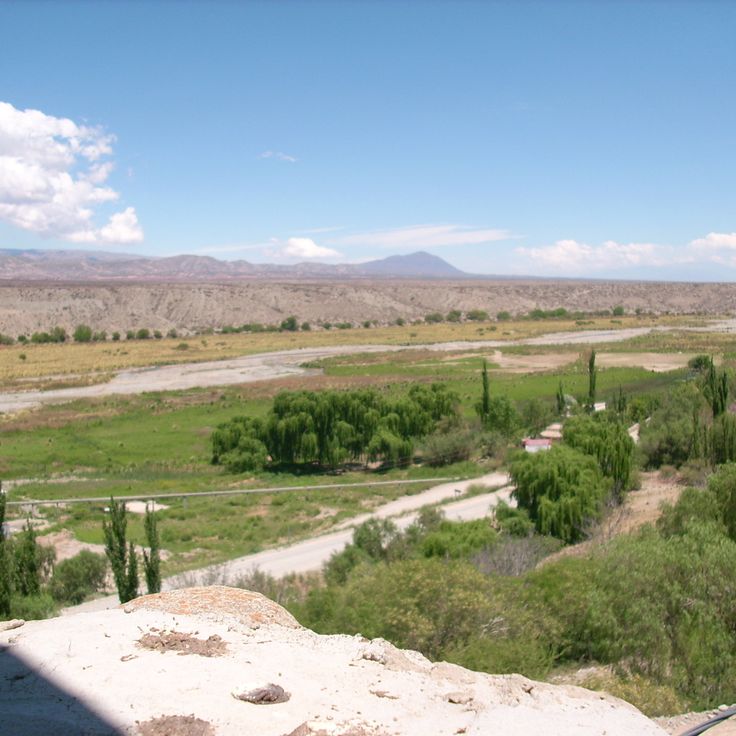
The Humahuaca Valley extends 155 kilometers through Jujuy Province, displaying rock formations in shades of red and purple. These geological structures formed through millions of years of erosion and mineral deposits. The valley served as a major trade route for the Inca Empire and contains archaeological remains of pre-Columbian settlements. Towns along the valley preserve colonial architecture and indigenous traditions.
The Inca Thermal Bridge is a 47-meter-long formation of mineral stone created by the continuous deposit of minerals from hot springs. The thermal waters flowing through this geological structure reach temperatures of approximately 35 degrees Celsius. This natural bridge is located in Mendoza Province and represents an example of geothermal activity in this region of the Argentine Andes.
Iguazu Falls comprises 275 individual cascades stretching across 2.7 kilometers. The Iguazu River plunges up to 82 meters into a gorge, generating permanent spray and mist. The Devil's Throat forms the centerpiece, a horseshoe-shaped chasm measuring 150 meters wide and 700 meters long.
Mount Fitz Roy rises 3405 meters above Los Glaciares National Park. The steep granite walls of this mountain draw alpinists from around the world. The summit often remains shrouded in clouds and reveals itself completely only a few days each year. Several hiking trails lead to viewpoints at the base of the mountain, including Laguna de los Tres.
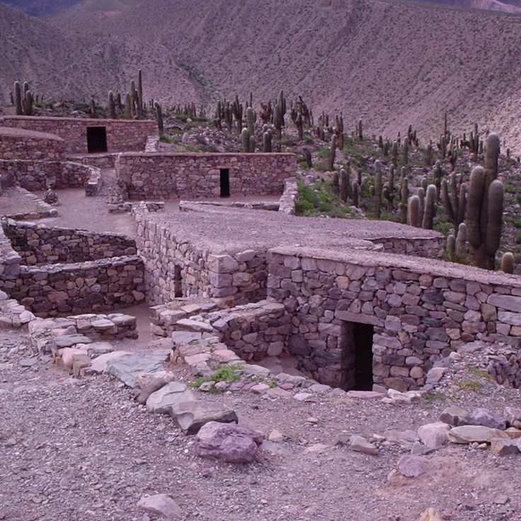
The Pucará de Tilcara consists of the remains of a 12th-century fortified settlement built on a hill in the Quebrada de Humahuaca. The site documents Omaguaca culture construction methods through preserved stone walls, agricultural terraces, and rectangular structures. The complex functioned as a defensive settlement and controlled important trade routes. Reconstructed sections display typical dwelling units and ceremonial spaces.
The Uspallata Valley is located in Mendoza Province and forms a natural corridor between Argentina and Chile through the Andes mountain range. The Inca civilization used this route as a major trade path, and today it is crossed by National Route 7. The valley sits at approximately 1,900 meters elevation and provides access to Aconcagua National Park.
Cajón del Azul is a river canyon in the Andes characterized by its turquoise-colored waters. Several marked hiking trails run along the canyon, offering different perspectives of the river and surrounding rock walls. The hike to the canyon begins near El Bolsón and passes through Valdivian rainforest terrain.
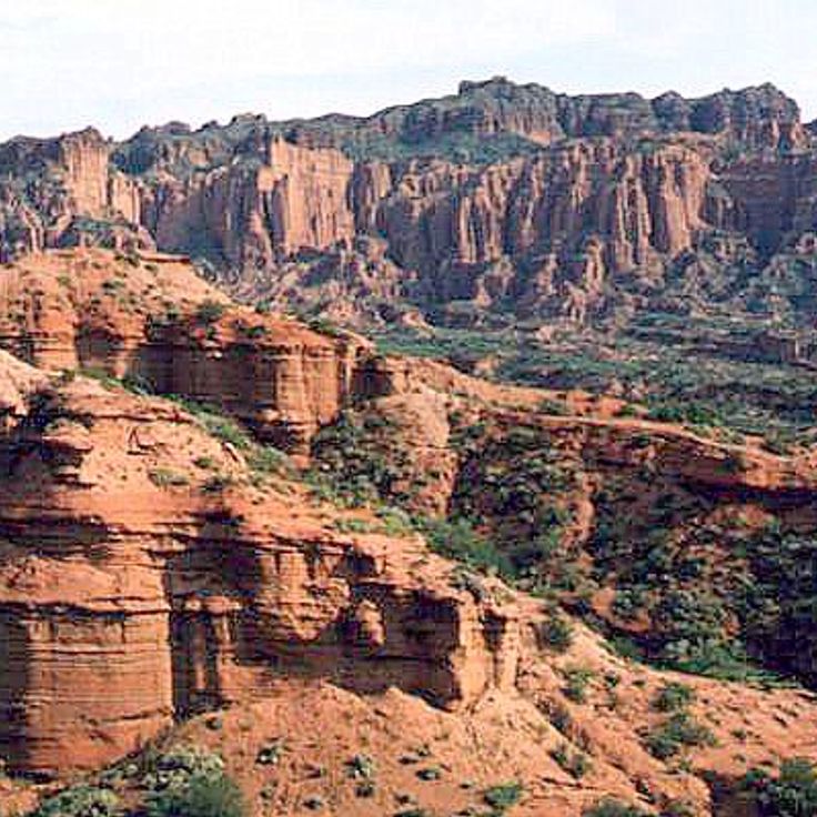
Talampaya National Park protects a desert landscape formed by red sandstone formations shaped over millions of years of erosion. The vertical rock walls reach heights of 150 meters, creating narrow canyons throughout the park. Paleontologists have discovered fossils of dinosaurs and other prehistoric reptiles from the Triassic period here. Indigenous peoples left petroglyphs on the rock walls depicting geometric patterns and animal figures.
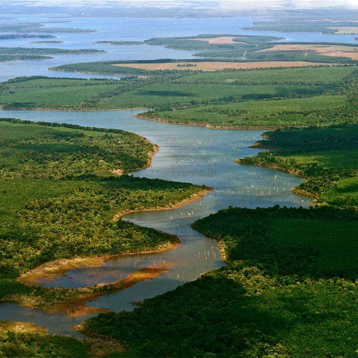
The Esteros del Iberá form one of South America's largest wetland systems, covering more than 13,000 square kilometers in Corrientes Province. The area consists of lagoons, marshes, floating islands and waterways. Visitors can observe capybaras, caimans, marsh deer and giant otters. Over 350 bird species inhabit the region, including storks, ibises and herons. Boat tours navigate through the channels and allow close wildlife observation. The reserve protects endangered species and serves as a reintroduction site for jaguars and giant anteaters.
Termas de Reyes is a natural thermal spring complex located in an Andean valley approximately 20 kilometers northwest of San Salvador de Jujuy. The springs emerge at varying temperatures between 22 and 84 degrees Celsius from different sources. The facility includes several pools and bathing areas used by local residents and visitors for therapeutic and recreational purposes. The surrounding landscape features typical Andean vegetation with mountains and river valleys.
La Cumbrecita is a car-free mountain village in the Córdoba Sierras, located at 1,450 meters elevation. The settlement was founded in 1934 by German immigrants and maintains its Central European character with alpine-style wooden houses. Visitors access the village on foot or by authorized shuttle buses. The surrounding area offers numerous hiking trails through pine forests leading to waterfalls, viewpoints, and rock formations. The cool mountain climate and dense vegetation contrast sharply with the surrounding Argentine landscapes.
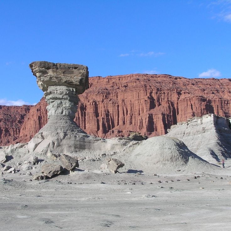
Valle de la Luna is a geological nature reserve in San Juan Province that displays red sandstone formations shaped by erosion. This region contains significant paleontological sites with fossils from the Triassic period, including early dinosaurs and other prehistoric reptiles. The various sedimentary layers document geological history spanning millions of years, making this site an important research area for scientists studying the evolution of life on Earth.
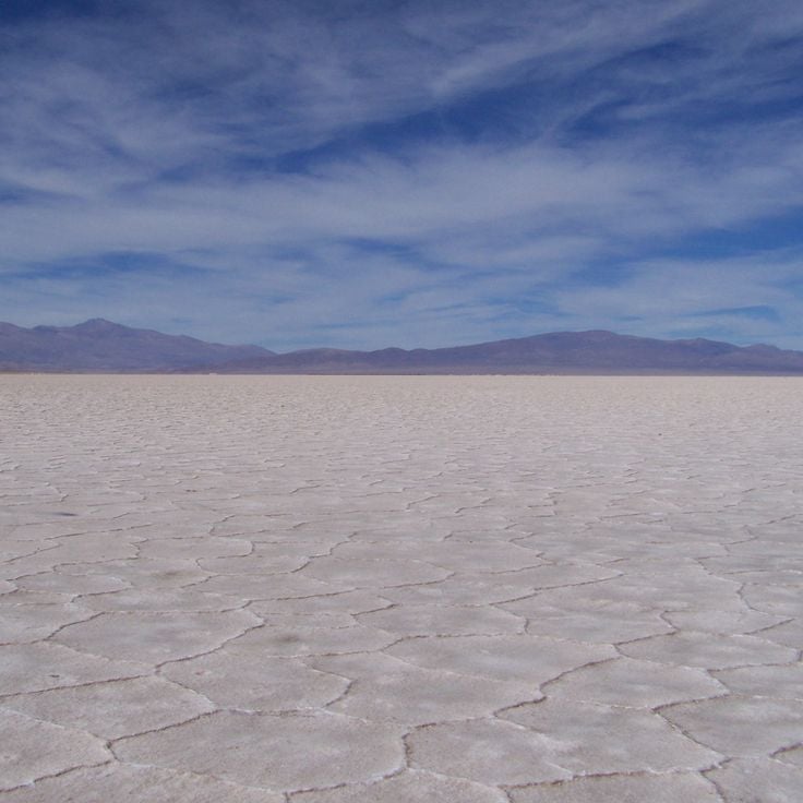
Salinas Grandes is an extensive salt lake situated at 3450 meters altitude in Jujuy Province. The white salt surface covers approximately 212 square kilometers, forming one of Argentina's largest salt deserts. Geometric extraction pools are used for traditional salt harvesting through evaporation. The site is located between Jujuy and Salta provinces on the Puna plateau.
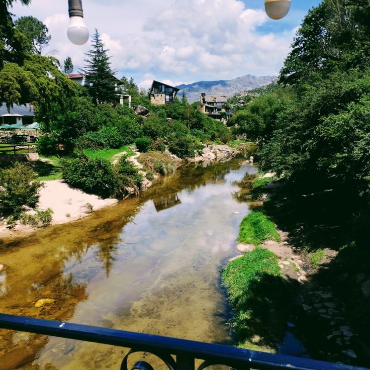
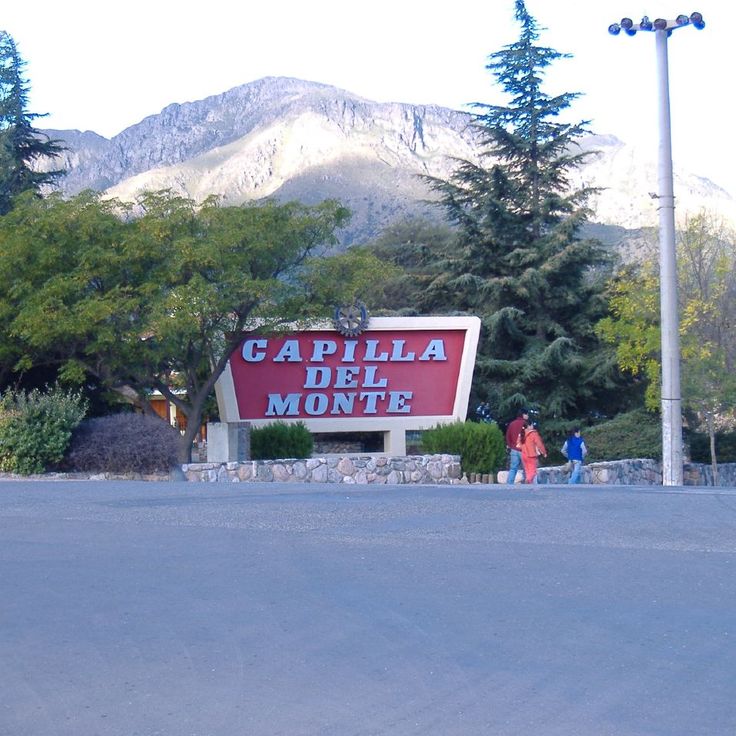
Capilla del Monte is a town in the Sierras Chicas range, known for Cerro Uritorco, a 1979-meter peak that attracts numerous hikers. The surrounding area offers various walking trails through mountainous terrain and features deposits of minerals and rock formations. The region serves as a base for exploring the nearby valleys and elevations of the Sierras range.
Los Alerces National Park covers 263,000 hectares in Chubut Province and protects ancient Alerce trees, some of which are over 3,000 years old. The park includes several glacial lakes with turquoise water, including Lago Futalaufquen and Lago Verde. The forests contain the Alerce tree, a species of cypress that ranks among the oldest living organisms on Earth. Visitors can hike on marked trails, take boat trips to remote areas, and explore the untouched Patagonian landscape.
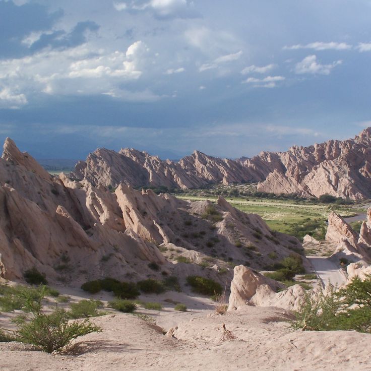
The Sierras de las Quijadas form a protected natural area characterized by distinctive red sandstone formations that have developed through millions of years of erosion. This national park covers approximately 150,000 hectares in San Luis Province. The rock formations reach heights of up to 120 meters, creating a labyrinth of canyons and valleys. The area was once an ocean floor during the Cretaceous period, which explains the discovery of numerous dinosaur fossils. Scientists have found remains of pterosaurs and various herbivorous dinosaurs here. The vegetation consists mainly of thorny shrubs and cacti adapted to the dry conditions.
The Sierra de la Ventana is a mountain system located in the southern part of Buenos Aires Province, with its highest point reaching 1,239 meters above sea level. This formation is part of the ancient Pampean mountain system and provides various ascending routes for hikers and climbers of different skill levels. The area includes several peaks, among them Cerro Tres Picos and Cerro de la Ventana, which features a distinctive natural rock window formation. The region serves as a base for outdoor activities and hosts diverse flora and fauna characteristic of the Pampas transition zone.
Villa Pehuenia sits at 1,200 meters elevation between Lago Aluminé and Lago Moquehue in the Patagonian Andes. The area is characterized by extensive forests of araucaria trees, which can live for several centuries. The settlement serves as a base for hiking, water sports on both lakes, and winter activities. These araucaria forests represent some of the southernmost populations of this tree species and are protected as part of the natural heritage.
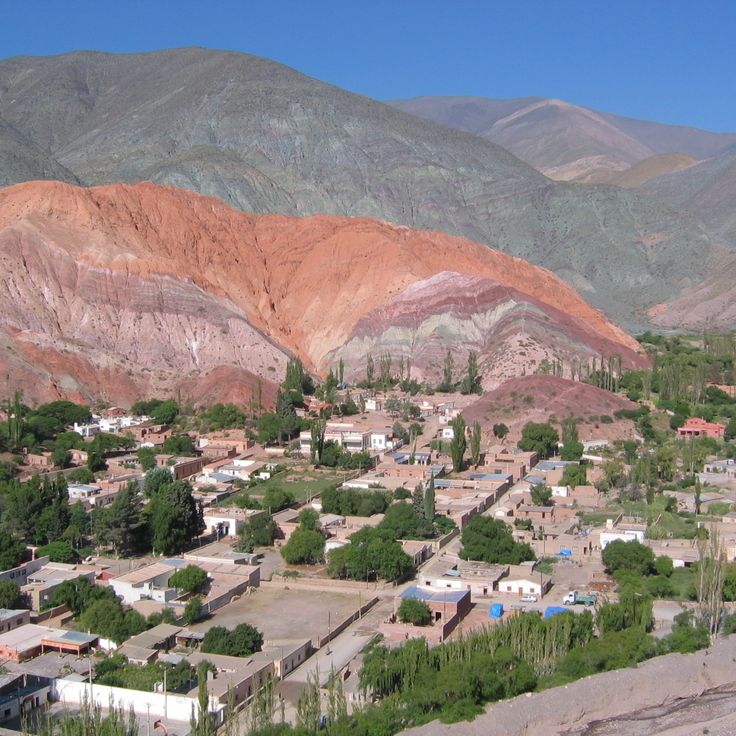
Cerro de los Siete Colores is a geological formation in the Quebrada de Humahuaca whose sedimentary layers appear in seven distinct colors due to various minerals and oxidation processes. The visible hues range from red and brown to yellow, orange, green and purple, created by iron oxides, copper sulfates and calcium carbonates. These layers formed over millions of years during different geological epochs and were exposed through tectonic movements.
Cachi is an Andean village situated at 2280 meters altitude, characterized by its colonial architecture. The houses are built from adobe and the streets maintain their historical character. The village serves as a starting point for visits to nearby archaeological sites and provides access to traditional artisan markets where local weaving techniques and ceramics are displayed.
El Maitén is a railroad town in Chubut Province known for its historic maintenance workshops serving the narrow gauge La Trochita railway line. The workshops date back to the 1920s and continue to maintain this traditional railway system. The town developed primarily around this railway infrastructure and preserves the technical heritage of Argentine narrow gauge railways.
Las Grutas sits on the coast of Río Negro and takes its name from the limestone caves carved into the cliffs by the sea. The town's beaches attract visitors who come to swim in the sheltered coves, where water temperatures rise to 25 degrees Celsius due to solar heating and tidal patterns. The caves are accessible on foot during low tide and provide shade along the shoreline.
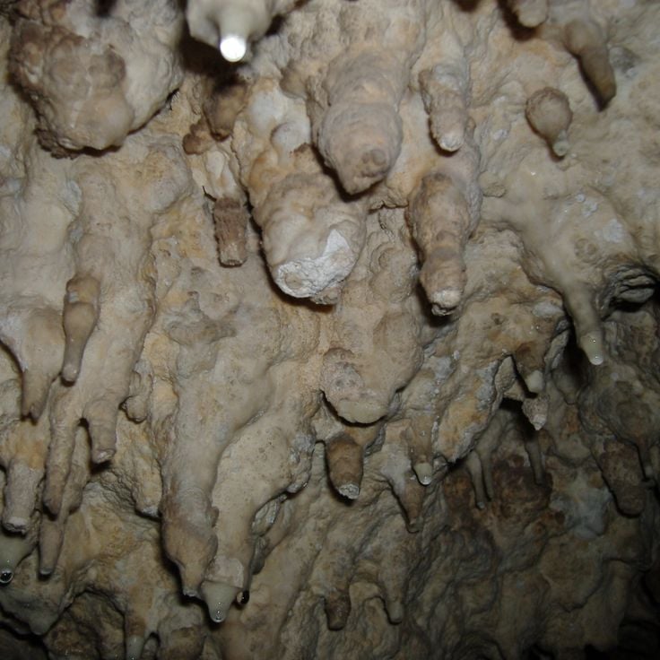
The Cueva de las Brujas is a limestone cave system that extends 150 meters below ground level. The cave displays various mineral formations, underground streams, and geological structures. Visitors can participate in guided tours that require safety equipment including helmets and lamps. Exploring the cave demands prior reservation and is accompanied by trained guides. The temperature inside the cave remains consistently cool throughout the year.
Villa La Angostura sits at 1000 meters elevation in the Patagonian Andes, combining wooden architecture with stone construction. The settlement stretches along the shore of Lake Nahuel Huapi, providing access to forested slopes and mountain trails. The center gathers restaurants serving regional Patagonian dishes alongside shops offering local products.
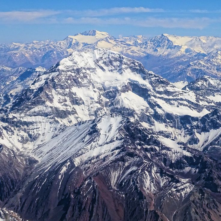
Cerro Aconcagua rises to 6962 meters, forming the highest summit in the Western and Southern Hemispheres. This massive formation of volcanic origin stands in the Andes near the Chilean border. Climbers from around the world undertake multi-day expeditions to this mountain, with official permits required. The normal route ascends through base camp Plaza de Mulas at approximately 4300 meters elevation.
Cholila sits in an Andean valley in Chubut Province and serves as a center for cattle ranching and horse breeding. The town hosts an annual meat grilling competition each January that draws visitors from the region. The surrounding grasslands extend to the foothills of the Andes and provide space for agricultural operations.
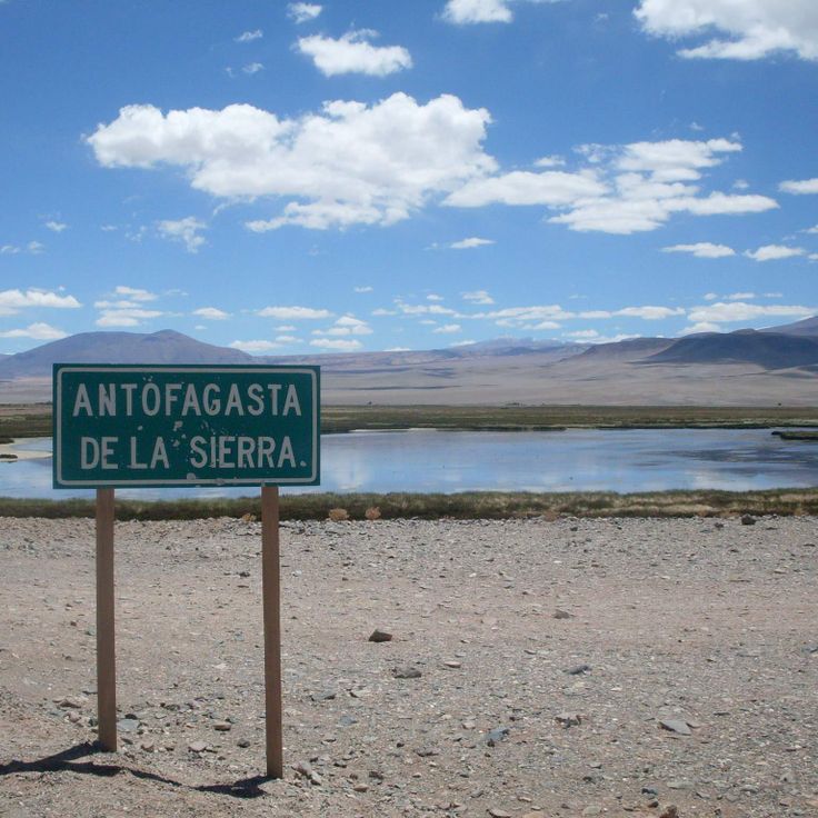
Antofagasta de la Sierra is a village in Catamarca Province located at an elevation of 3400 meters above sea level. The settlement is surrounded by extensive salt flats and volcanic rock formations that characterize the Puna highlands. The area experiences dry high-altitude conditions typical of the Andean plateau. The village serves as a base for exploring the surrounding geological formations and salt plains.
The Ruins of Quilmes spread across the slopes of the Calchaquí Valley and present the remains of a pre-Columbian settlement inhabited between the 9th and 17th centuries. The stone structures include residential areas, terraces, and ceremonial spaces built by the Quilmes people. The site documents the architectural techniques and social organization of this community, which resisted Spanish conquest until 1667.
Colonia Carlos Pellegrini is a small village located on the edge of the Iberá Wetlands in Corrientes Province. The settlement functions as the main access point for exploring the surrounding marshlands, where visitors can observe capybaras, caimans, marsh deer, and over 350 bird species in their natural habitat. The area offers guided boat tours and horseback riding excursions through the expansive water bodies and floating islands of the nature reserve.
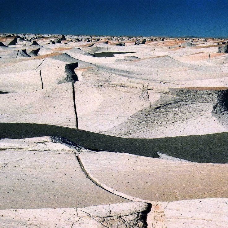
Campo de Piedra Pómez covers 25 square kilometers in Catamarca Province and consists of white pumice stone formations of volcanic origin. This geological site formed millions of years ago through intense volcanic activity in the region. The landscape displays unusual rock formations made of porous volcanic material, shaped by erosion into various forms. Located at over 3000 meters altitude in the Puna region, the area presents contrasts between the light-colored pumice deposits and the surrounding sparse highland vegetation.
The Payunia Volcanic Field extends across 30,000 square kilometers in Mendoza Province and contains more than 800 volcanic cones along with extensive black basalt flows. This geological area is located in the southern part of the province and demonstrates the volcanic activity that has shaped this region over thousands of years. The landscape consists of extinct craters, lava fields, and volcanic formations in various states of preservation.
Lake Posadas sits in the Patagonian steppe and features turquoise, mineral-rich water. The shoreline is bordered by red volcanic rock formations shaped over millennia by wind and erosion. Several cave systems in the surrounding area contain prehistoric rock paintings. The lake covers approximately 48 square kilometers and connects to the neighboring Lake Pueyrredón through a narrow channel. The contrasting colors of the water and rocks create a distinctive landscape in this remote region of southern Argentina.
The Quebrada de las Flechas is a canyon in Salta Province formed by thousands of years of erosion. The vertical sandstone formations rise approximately 20 meters high and display distinct rock layering. This canyon is located along Route 40 between Angastaco and Cafayate in the Calchaquí Valleys.
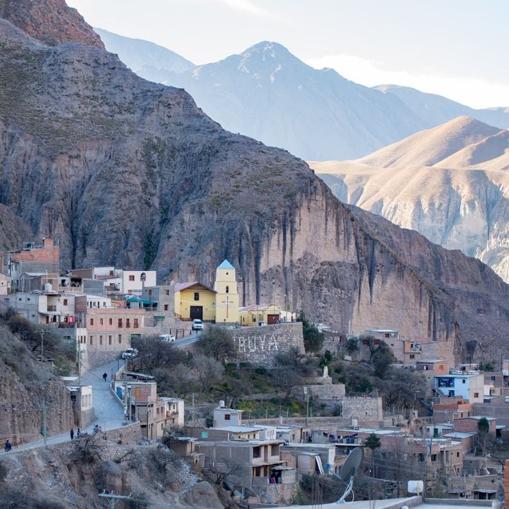
The mountain village of Iruya sits at 2,780 meters altitude in the Argentine Andes. Narrow cobblestone lanes wind between adobe houses that cling to steep slopes. Red rock walls surround the settlement and define the landscape. Access requires a winding mountain road through the Humahuaca Valley. Residents maintain traditional ways of life and agricultural practices.
Quebrada de los Condores is a canyon located in La Rioja province, characterized by steep rock walls and its importance as a habitat for Andean condors. Visitors can observe these large raptors during their flight maneuvers along the cliffs, particularly in the morning hours when thermal updrafts facilitate soaring. The canyon extends through arid terrain with vegetation typical of the Argentine Andes and provides several viewpoints for bird watching.
Cueva de las Manos is an archaeological site located in the valley of the Río Pinturas. This cave preserves over 800 hand prints and depictions of hunting scenes created approximately 13,000 years ago by prehistoric hunter-gatherer communities. The rock art features predominantly left hands rendered in red ochre, along with representations of guanacos and geometric patterns.
Ojo de Mar is a natural water basin located in the salt desert of Salta province. Underground springs continuously feed this body of water with mineral-rich content. The exceptional clarity of the water allows visibility of mineral deposits on the basin floor. This geological formation resulted from the interaction between groundwater flows and the surrounding salt-rich environment.
Villa Traful is a small village of approximately 400 inhabitants located on the shore of Lake Traful in the northern Patagonian province of Neuquén. The village sits nestled between forested slopes and mountains within Nahuel Huapi National Park. The lake provides opportunities for diving, kayaking, and fishing. Hiking trails lead through lenga and ñire forests to viewpoints and waterfalls. The area receives considerably fewer visitors than the nearby tourist centers of San Martín de los Andes and Bariloche.
The Jaramillo Geological Preserve spans 15,000 hectares in Santa Cruz Province and protects one of the most significant petrified araucaria forests from the Jurassic period. The fossilized trees formed approximately 150 million years ago when volcanic activity buried the forest under layers of ash. The specimens preserve details of the wood structure and reach diameters of up to 3 meters. The preserve occupies a semi-arid plateau and documents the prehistoric flora of Patagonia.
El Palmar National Park covers 8,500 hectares in eastern Argentina and protects one of the last major stands of Yatay palms. This palm species defines the park's landscape, forming open savannas. The park is home to armadillos, rheas, and over 200 bird species, including various parrots and raptors. Walking trails lead through the palm groves and along the Uruguay River. The region provides opportunities for wildlife observation, particularly during early morning and evening hours.
The Humahuaca Valley extends 155 kilometers through Jujuy Province, displaying rock formations in shades of red and purple. These geological structures formed through millions of years of erosion and mineral deposits. The valley served as a major trade route for the Inca Empire and contains archaeological remains of pre-Columbian settlements. Towns along the valley preserve colonial architecture and indigenous traditions.
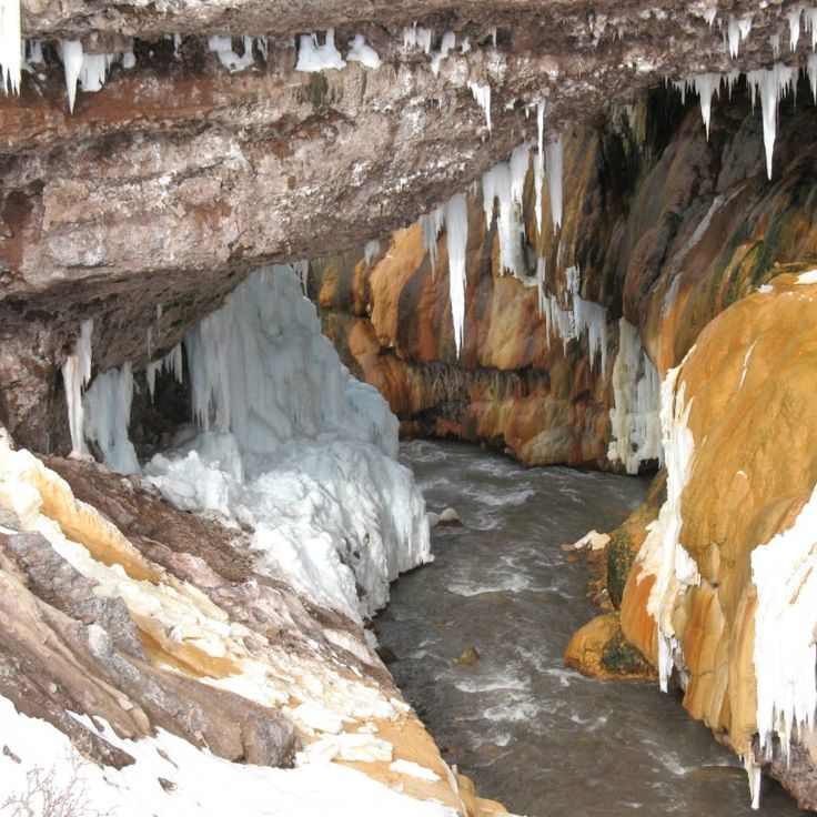
The Inca Thermal Bridge is a 47-meter-long formation of mineral stone created by the continuous deposit of minerals from hot springs. The thermal waters flowing through this geological structure reach temperatures of approximately 35 degrees Celsius. This natural bridge is located in Mendoza Province and represents an example of geothermal activity in this region of the Argentine Andes.
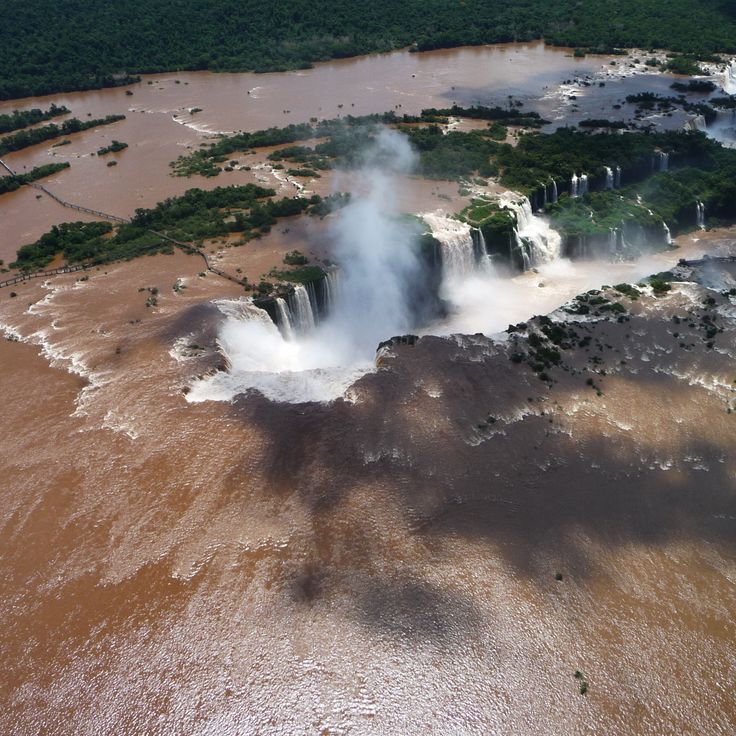
Iguazu Falls comprises 275 individual cascades stretching across 2.7 kilometers. The Iguazu River plunges up to 82 meters into a gorge, generating permanent spray and mist. The Devil's Throat forms the centerpiece, a horseshoe-shaped chasm measuring 150 meters wide and 700 meters long.
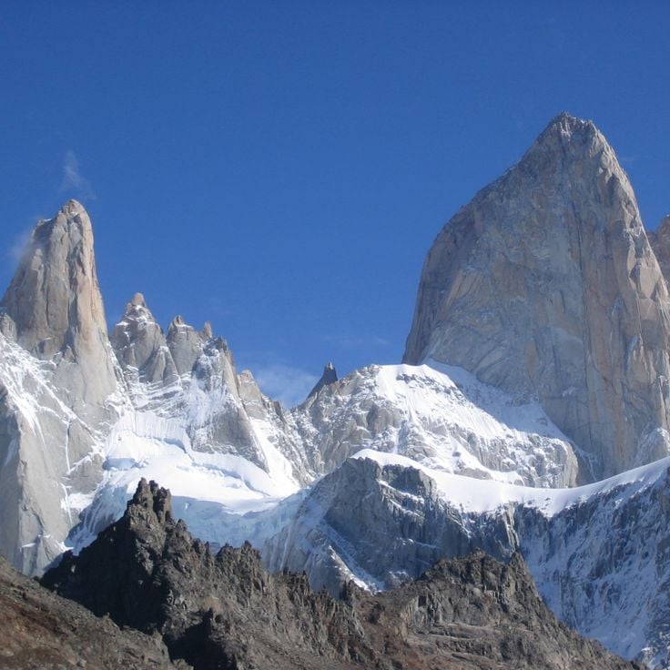
Mount Fitz Roy rises 3405 meters above Los Glaciares National Park. The steep granite walls of this mountain draw alpinists from around the world. The summit often remains shrouded in clouds and reveals itself completely only a few days each year. Several hiking trails lead to viewpoints at the base of the mountain, including Laguna de los Tres.
The Pucará de Tilcara consists of the remains of a 12th-century fortified settlement built on a hill in the Quebrada de Humahuaca. The site documents Omaguaca culture construction methods through preserved stone walls, agricultural terraces, and rectangular structures. The complex functioned as a defensive settlement and controlled important trade routes. Reconstructed sections display typical dwelling units and ceremonial spaces.
The Uspallata Valley is located in Mendoza Province and forms a natural corridor between Argentina and Chile through the Andes mountain range. The Inca civilization used this route as a major trade path, and today it is crossed by National Route 7. The valley sits at approximately 1,900 meters elevation and provides access to Aconcagua National Park.
Cajón del Azul is a river canyon in the Andes characterized by its turquoise-colored waters. Several marked hiking trails run along the canyon, offering different perspectives of the river and surrounding rock walls. The hike to the canyon begins near El Bolsón and passes through Valdivian rainforest terrain.
Talampaya National Park protects a desert landscape formed by red sandstone formations shaped over millions of years of erosion. The vertical rock walls reach heights of 150 meters, creating narrow canyons throughout the park. Paleontologists have discovered fossils of dinosaurs and other prehistoric reptiles from the Triassic period here. Indigenous peoples left petroglyphs on the rock walls depicting geometric patterns and animal figures.
The Esteros del Iberá form one of South America's largest wetland systems, covering more than 13,000 square kilometers in Corrientes Province. The area consists of lagoons, marshes, floating islands and waterways. Visitors can observe capybaras, caimans, marsh deer and giant otters. Over 350 bird species inhabit the region, including storks, ibises and herons. Boat tours navigate through the channels and allow close wildlife observation. The reserve protects endangered species and serves as a reintroduction site for jaguars and giant anteaters.
Termas de Reyes is a natural thermal spring complex located in an Andean valley approximately 20 kilometers northwest of San Salvador de Jujuy. The springs emerge at varying temperatures between 22 and 84 degrees Celsius from different sources. The facility includes several pools and bathing areas used by local residents and visitors for therapeutic and recreational purposes. The surrounding landscape features typical Andean vegetation with mountains and river valleys.
La Cumbrecita is a car-free mountain village in the Córdoba Sierras, located at 1,450 meters elevation. The settlement was founded in 1934 by German immigrants and maintains its Central European character with alpine-style wooden houses. Visitors access the village on foot or by authorized shuttle buses. The surrounding area offers numerous hiking trails through pine forests leading to waterfalls, viewpoints, and rock formations. The cool mountain climate and dense vegetation contrast sharply with the surrounding Argentine landscapes.
Valle de la Luna is a geological nature reserve in San Juan Province that displays red sandstone formations shaped by erosion. This region contains significant paleontological sites with fossils from the Triassic period, including early dinosaurs and other prehistoric reptiles. The various sedimentary layers document geological history spanning millions of years, making this site an important research area for scientists studying the evolution of life on Earth.
Salinas Grandes is an extensive salt lake situated at 3450 meters altitude in Jujuy Province. The white salt surface covers approximately 212 square kilometers, forming one of Argentina's largest salt deserts. Geometric extraction pools are used for traditional salt harvesting through evaporation. The site is located between Jujuy and Salta provinces on the Puna plateau.
Capilla del Monte is a town in the Sierras Chicas range, known for Cerro Uritorco, a 1979-meter peak that attracts numerous hikers. The surrounding area offers various walking trails through mountainous terrain and features deposits of minerals and rock formations. The region serves as a base for exploring the nearby valleys and elevations of the Sierras range.
Los Alerces National Park covers 263,000 hectares in Chubut Province and protects ancient Alerce trees, some of which are over 3,000 years old. The park includes several glacial lakes with turquoise water, including Lago Futalaufquen and Lago Verde. The forests contain the Alerce tree, a species of cypress that ranks among the oldest living organisms on Earth. Visitors can hike on marked trails, take boat trips to remote areas, and explore the untouched Patagonian landscape.
The Sierras de las Quijadas form a protected natural area characterized by distinctive red sandstone formations that have developed through millions of years of erosion. This national park covers approximately 150,000 hectares in San Luis Province. The rock formations reach heights of up to 120 meters, creating a labyrinth of canyons and valleys. The area was once an ocean floor during the Cretaceous period, which explains the discovery of numerous dinosaur fossils. Scientists have found remains of pterosaurs and various herbivorous dinosaurs here. The vegetation consists mainly of thorny shrubs and cacti adapted to the dry conditions.
The Sierra de la Ventana is a mountain system located in the southern part of Buenos Aires Province, with its highest point reaching 1,239 meters above sea level. This formation is part of the ancient Pampean mountain system and provides various ascending routes for hikers and climbers of different skill levels. The area includes several peaks, among them Cerro Tres Picos and Cerro de la Ventana, which features a distinctive natural rock window formation. The region serves as a base for outdoor activities and hosts diverse flora and fauna characteristic of the Pampas transition zone.
Villa Pehuenia sits at 1,200 meters elevation between Lago Aluminé and Lago Moquehue in the Patagonian Andes. The area is characterized by extensive forests of araucaria trees, which can live for several centuries. The settlement serves as a base for hiking, water sports on both lakes, and winter activities. These araucaria forests represent some of the southernmost populations of this tree species and are protected as part of the natural heritage.
Cerro de los Siete Colores is a geological formation in the Quebrada de Humahuaca whose sedimentary layers appear in seven distinct colors due to various minerals and oxidation processes. The visible hues range from red and brown to yellow, orange, green and purple, created by iron oxides, copper sulfates and calcium carbonates. These layers formed over millions of years during different geological epochs and were exposed through tectonic movements.
Cachi is an Andean village situated at 2280 meters altitude, characterized by its colonial architecture. The houses are built from adobe and the streets maintain their historical character. The village serves as a starting point for visits to nearby archaeological sites and provides access to traditional artisan markets where local weaving techniques and ceramics are displayed.
El Maitén is a railroad town in Chubut Province known for its historic maintenance workshops serving the narrow gauge La Trochita railway line. The workshops date back to the 1920s and continue to maintain this traditional railway system. The town developed primarily around this railway infrastructure and preserves the technical heritage of Argentine narrow gauge railways.
Las Grutas sits on the coast of Río Negro and takes its name from the limestone caves carved into the cliffs by the sea. The town's beaches attract visitors who come to swim in the sheltered coves, where water temperatures rise to 25 degrees Celsius due to solar heating and tidal patterns. The caves are accessible on foot during low tide and provide shade along the shoreline.
The Cueva de las Brujas is a limestone cave system that extends 150 meters below ground level. The cave displays various mineral formations, underground streams, and geological structures. Visitors can participate in guided tours that require safety equipment including helmets and lamps. Exploring the cave demands prior reservation and is accompanied by trained guides. The temperature inside the cave remains consistently cool throughout the year.
Villa La Angostura sits at 1000 meters elevation in the Patagonian Andes, combining wooden architecture with stone construction. The settlement stretches along the shore of Lake Nahuel Huapi, providing access to forested slopes and mountain trails. The center gathers restaurants serving regional Patagonian dishes alongside shops offering local products.
Cerro Aconcagua rises to 6962 meters, forming the highest summit in the Western and Southern Hemispheres. This massive formation of volcanic origin stands in the Andes near the Chilean border. Climbers from around the world undertake multi-day expeditions to this mountain, with official permits required. The normal route ascends through base camp Plaza de Mulas at approximately 4300 meters elevation.
Cholila sits in an Andean valley in Chubut Province and serves as a center for cattle ranching and horse breeding. The town hosts an annual meat grilling competition each January that draws visitors from the region. The surrounding grasslands extend to the foothills of the Andes and provide space for agricultural operations.
Antofagasta de la Sierra is a village in Catamarca Province located at an elevation of 3400 meters above sea level. The settlement is surrounded by extensive salt flats and volcanic rock formations that characterize the Puna highlands. The area experiences dry high-altitude conditions typical of the Andean plateau. The village serves as a base for exploring the surrounding geological formations and salt plains.
The Ruins of Quilmes spread across the slopes of the Calchaquí Valley and present the remains of a pre-Columbian settlement inhabited between the 9th and 17th centuries. The stone structures include residential areas, terraces, and ceremonial spaces built by the Quilmes people. The site documents the architectural techniques and social organization of this community, which resisted Spanish conquest until 1667.
Colonia Carlos Pellegrini is a small village located on the edge of the Iberá Wetlands in Corrientes Province. The settlement functions as the main access point for exploring the surrounding marshlands, where visitors can observe capybaras, caimans, marsh deer, and over 350 bird species in their natural habitat. The area offers guided boat tours and horseback riding excursions through the expansive water bodies and floating islands of the nature reserve.
Campo de Piedra Pómez covers 25 square kilometers in Catamarca Province and consists of white pumice stone formations of volcanic origin. This geological site formed millions of years ago through intense volcanic activity in the region. The landscape displays unusual rock formations made of porous volcanic material, shaped by erosion into various forms. Located at over 3000 meters altitude in the Puna region, the area presents contrasts between the light-colored pumice deposits and the surrounding sparse highland vegetation.
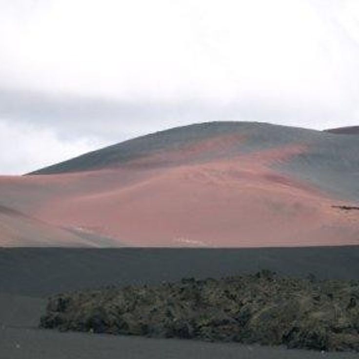
The Payunia Volcanic Field extends across 30,000 square kilometers in Mendoza Province and contains more than 800 volcanic cones along with extensive black basalt flows. This geological area is located in the southern part of the province and demonstrates the volcanic activity that has shaped this region over thousands of years. The landscape consists of extinct craters, lava fields, and volcanic formations in various states of preservation.
Lake Posadas sits in the Patagonian steppe and features turquoise, mineral-rich water. The shoreline is bordered by red volcanic rock formations shaped over millennia by wind and erosion. Several cave systems in the surrounding area contain prehistoric rock paintings. The lake covers approximately 48 square kilometers and connects to the neighboring Lake Pueyrredón through a narrow channel. The contrasting colors of the water and rocks create a distinctive landscape in this remote region of southern Argentina.
The Quebrada de las Flechas is a canyon in Salta Province formed by thousands of years of erosion. The vertical sandstone formations rise approximately 20 meters high and display distinct rock layering. This canyon is located along Route 40 between Angastaco and Cafayate in the Calchaquí Valleys.
The mountain village of Iruya sits at 2,780 meters altitude in the Argentine Andes. Narrow cobblestone lanes wind between adobe houses that cling to steep slopes. Red rock walls surround the settlement and define the landscape. Access requires a winding mountain road through the Humahuaca Valley. Residents maintain traditional ways of life and agricultural practices.
Quebrada de los Condores is a canyon located in La Rioja province, characterized by steep rock walls and its importance as a habitat for Andean condors. Visitors can observe these large raptors during their flight maneuvers along the cliffs, particularly in the morning hours when thermal updrafts facilitate soaring. The canyon extends through arid terrain with vegetation typical of the Argentine Andes and provides several viewpoints for bird watching.
Cueva de las Manos is an archaeological site located in the valley of the Río Pinturas. This cave preserves over 800 hand prints and depictions of hunting scenes created approximately 13,000 years ago by prehistoric hunter-gatherer communities. The rock art features predominantly left hands rendered in red ochre, along with representations of guanacos and geometric patterns.
Ojo de Mar is a natural water basin located in the salt desert of Salta province. Underground springs continuously feed this body of water with mineral-rich content. The exceptional clarity of the water allows visibility of mineral deposits on the basin floor. This geological formation resulted from the interaction between groundwater flows and the surrounding salt-rich environment.
Villa Traful is a small village of approximately 400 inhabitants located on the shore of Lake Traful in the northern Patagonian province of Neuquén. The village sits nestled between forested slopes and mountains within Nahuel Huapi National Park. The lake provides opportunities for diving, kayaking, and fishing. Hiking trails lead through lenga and ñire forests to viewpoints and waterfalls. The area receives considerably fewer visitors than the nearby tourist centers of San Martín de los Andes and Bariloche.
The Jaramillo Geological Preserve spans 15,000 hectares in Santa Cruz Province and protects one of the most significant petrified araucaria forests from the Jurassic period. The fossilized trees formed approximately 150 million years ago when volcanic activity buried the forest under layers of ash. The specimens preserve details of the wood structure and reach diameters of up to 3 meters. The preserve occupies a semi-arid plateau and documents the prehistoric flora of Patagonia.
El Palmar National Park covers 8,500 hectares in eastern Argentina and protects one of the last major stands of Yatay palms. This palm species defines the park's landscape, forming open savannas. The park is home to armadillos, rheas, and over 200 bird species, including various parrots and raptors. Walking trails lead through the palm groves and along the Uruguay River. The region provides opportunities for wildlife observation, particularly during early morning and evening hours.
The Humahuaca Valley extends 155 kilometers through Jujuy Province, displaying rock formations in shades of red and purple. These geological structures formed through millions of years of erosion and mineral deposits. The valley served as a major trade route for the Inca Empire and contains archaeological remains of pre-Columbian settlements. Towns along the valley preserve colonial architecture and indigenous traditions.
The Inca Thermal Bridge is a 47-meter-long formation of mineral stone created by the continuous deposit of minerals from hot springs. The thermal waters flowing through this geological structure reach temperatures of approximately 35 degrees Celsius. This natural bridge is located in Mendoza Province and represents an example of geothermal activity in this region of the Argentine Andes.
Iguazu Falls comprises 275 individual cascades stretching across 2.7 kilometers. The Iguazu River plunges up to 82 meters into a gorge, generating permanent spray and mist. The Devil's Throat forms the centerpiece, a horseshoe-shaped chasm measuring 150 meters wide and 700 meters long.
Mount Fitz Roy rises 3405 meters above Los Glaciares National Park. The steep granite walls of this mountain draw alpinists from around the world. The summit often remains shrouded in clouds and reveals itself completely only a few days each year. Several hiking trails lead to viewpoints at the base of the mountain, including Laguna de los Tres.
The Pucará de Tilcara consists of the remains of a 12th-century fortified settlement built on a hill in the Quebrada de Humahuaca. The site documents Omaguaca culture construction methods through preserved stone walls, agricultural terraces, and rectangular structures. The complex functioned as a defensive settlement and controlled important trade routes. Reconstructed sections display typical dwelling units and ceremonial spaces.
The Uspallata Valley is located in Mendoza Province and forms a natural corridor between Argentina and Chile through the Andes mountain range. The Inca civilization used this route as a major trade path, and today it is crossed by National Route 7. The valley sits at approximately 1,900 meters elevation and provides access to Aconcagua National Park.
Cajón del Azul is a river canyon in the Andes characterized by its turquoise-colored waters. Several marked hiking trails run along the canyon, offering different perspectives of the river and surrounding rock walls. The hike to the canyon begins near El Bolsón and passes through Valdivian rainforest terrain.
Talampaya National Park protects a desert landscape formed by red sandstone formations shaped over millions of years of erosion. The vertical rock walls reach heights of 150 meters, creating narrow canyons throughout the park. Paleontologists have discovered fossils of dinosaurs and other prehistoric reptiles from the Triassic period here. Indigenous peoples left petroglyphs on the rock walls depicting geometric patterns and animal figures.
The Esteros del Iberá form one of South America's largest wetland systems, covering more than 13,000 square kilometers in Corrientes Province. The area consists of lagoons, marshes, floating islands and waterways. Visitors can observe capybaras, caimans, marsh deer and giant otters. Over 350 bird species inhabit the region, including storks, ibises and herons. Boat tours navigate through the channels and allow close wildlife observation. The reserve protects endangered species and serves as a reintroduction site for jaguars and giant anteaters.
Termas de Reyes is a natural thermal spring complex located in an Andean valley approximately 20 kilometers northwest of San Salvador de Jujuy. The springs emerge at varying temperatures between 22 and 84 degrees Celsius from different sources. The facility includes several pools and bathing areas used by local residents and visitors for therapeutic and recreational purposes. The surrounding landscape features typical Andean vegetation with mountains and river valleys.
La Cumbrecita is a car-free mountain village in the Córdoba Sierras, located at 1,450 meters elevation. The settlement was founded in 1934 by German immigrants and maintains its Central European character with alpine-style wooden houses. Visitors access the village on foot or by authorized shuttle buses. The surrounding area offers numerous hiking trails through pine forests leading to waterfalls, viewpoints, and rock formations. The cool mountain climate and dense vegetation contrast sharply with the surrounding Argentine landscapes.
Valle de la Luna is a geological nature reserve in San Juan Province that displays red sandstone formations shaped by erosion. This region contains significant paleontological sites with fossils from the Triassic period, including early dinosaurs and other prehistoric reptiles. The various sedimentary layers document geological history spanning millions of years, making this site an important research area for scientists studying the evolution of life on Earth.
Salinas Grandes is an extensive salt lake situated at 3450 meters altitude in Jujuy Province. The white salt surface covers approximately 212 square kilometers, forming one of Argentina's largest salt deserts. Geometric extraction pools are used for traditional salt harvesting through evaporation. The site is located between Jujuy and Salta provinces on the Puna plateau.
Capilla del Monte is a town in the Sierras Chicas range, known for Cerro Uritorco, a 1979-meter peak that attracts numerous hikers. The surrounding area offers various walking trails through mountainous terrain and features deposits of minerals and rock formations. The region serves as a base for exploring the nearby valleys and elevations of the Sierras range.
Los Alerces National Park covers 263,000 hectares in Chubut Province and protects ancient Alerce trees, some of which are over 3,000 years old. The park includes several glacial lakes with turquoise water, including Lago Futalaufquen and Lago Verde. The forests contain the Alerce tree, a species of cypress that ranks among the oldest living organisms on Earth. Visitors can hike on marked trails, take boat trips to remote areas, and explore the untouched Patagonian landscape.
The Sierras de las Quijadas form a protected natural area characterized by distinctive red sandstone formations that have developed through millions of years of erosion. This national park covers approximately 150,000 hectares in San Luis Province. The rock formations reach heights of up to 120 meters, creating a labyrinth of canyons and valleys. The area was once an ocean floor during the Cretaceous period, which explains the discovery of numerous dinosaur fossils. Scientists have found remains of pterosaurs and various herbivorous dinosaurs here. The vegetation consists mainly of thorny shrubs and cacti adapted to the dry conditions.
The Sierra de la Ventana is a mountain system located in the southern part of Buenos Aires Province, with its highest point reaching 1,239 meters above sea level. This formation is part of the ancient Pampean mountain system and provides various ascending routes for hikers and climbers of different skill levels. The area includes several peaks, among them Cerro Tres Picos and Cerro de la Ventana, which features a distinctive natural rock window formation. The region serves as a base for outdoor activities and hosts diverse flora and fauna characteristic of the Pampas transition zone.
Villa Pehuenia sits at 1,200 meters elevation between Lago Aluminé and Lago Moquehue in the Patagonian Andes. The area is characterized by extensive forests of araucaria trees, which can live for several centuries. The settlement serves as a base for hiking, water sports on both lakes, and winter activities. These araucaria forests represent some of the southernmost populations of this tree species and are protected as part of the natural heritage.
Cerro de los Siete Colores is a geological formation in the Quebrada de Humahuaca whose sedimentary layers appear in seven distinct colors due to various minerals and oxidation processes. The visible hues range from red and brown to yellow, orange, green and purple, created by iron oxides, copper sulfates and calcium carbonates. These layers formed over millions of years during different geological epochs and were exposed through tectonic movements.
Cachi is an Andean village situated at 2280 meters altitude, characterized by its colonial architecture. The houses are built from adobe and the streets maintain their historical character. The village serves as a starting point for visits to nearby archaeological sites and provides access to traditional artisan markets where local weaving techniques and ceramics are displayed.
El Maitén is a railroad town in Chubut Province known for its historic maintenance workshops serving the narrow gauge La Trochita railway line. The workshops date back to the 1920s and continue to maintain this traditional railway system. The town developed primarily around this railway infrastructure and preserves the technical heritage of Argentine narrow gauge railways.
Las Grutas sits on the coast of Río Negro and takes its name from the limestone caves carved into the cliffs by the sea. The town's beaches attract visitors who come to swim in the sheltered coves, where water temperatures rise to 25 degrees Celsius due to solar heating and tidal patterns. The caves are accessible on foot during low tide and provide shade along the shoreline.
The Cueva de las Brujas is a limestone cave system that extends 150 meters below ground level. The cave displays various mineral formations, underground streams, and geological structures. Visitors can participate in guided tours that require safety equipment including helmets and lamps. Exploring the cave demands prior reservation and is accompanied by trained guides. The temperature inside the cave remains consistently cool throughout the year.
Villa La Angostura sits at 1000 meters elevation in the Patagonian Andes, combining wooden architecture with stone construction. The settlement stretches along the shore of Lake Nahuel Huapi, providing access to forested slopes and mountain trails. The center gathers restaurants serving regional Patagonian dishes alongside shops offering local products.
Cerro Aconcagua rises to 6962 meters, forming the highest summit in the Western and Southern Hemispheres. This massive formation of volcanic origin stands in the Andes near the Chilean border. Climbers from around the world undertake multi-day expeditions to this mountain, with official permits required. The normal route ascends through base camp Plaza de Mulas at approximately 4300 meters elevation.
Cholila sits in an Andean valley in Chubut Province and serves as a center for cattle ranching and horse breeding. The town hosts an annual meat grilling competition each January that draws visitors from the region. The surrounding grasslands extend to the foothills of the Andes and provide space for agricultural operations.
Antofagasta de la Sierra is a village in Catamarca Province located at an elevation of 3400 meters above sea level. The settlement is surrounded by extensive salt flats and volcanic rock formations that characterize the Puna highlands. The area experiences dry high-altitude conditions typical of the Andean plateau. The village serves as a base for exploring the surrounding geological formations and salt plains.
The Ruins of Quilmes spread across the slopes of the Calchaquí Valley and present the remains of a pre-Columbian settlement inhabited between the 9th and 17th centuries. The stone structures include residential areas, terraces, and ceremonial spaces built by the Quilmes people. The site documents the architectural techniques and social organization of this community, which resisted Spanish conquest until 1667.
Colonia Carlos Pellegrini is a small village located on the edge of the Iberá Wetlands in Corrientes Province. The settlement functions as the main access point for exploring the surrounding marshlands, where visitors can observe capybaras, caimans, marsh deer, and over 350 bird species in their natural habitat. The area offers guided boat tours and horseback riding excursions through the expansive water bodies and floating islands of the nature reserve.
Campo de Piedra Pómez covers 25 square kilometers in Catamarca Province and consists of white pumice stone formations of volcanic origin. This geological site formed millions of years ago through intense volcanic activity in the region. The landscape displays unusual rock formations made of porous volcanic material, shaped by erosion into various forms. Located at over 3000 meters altitude in the Puna region, the area presents contrasts between the light-colored pumice deposits and the surrounding sparse highland vegetation.
The Payunia Volcanic Field extends across 30,000 square kilometers in Mendoza Province and contains more than 800 volcanic cones along with extensive black basalt flows. This geological area is located in the southern part of the province and demonstrates the volcanic activity that has shaped this region over thousands of years. The landscape consists of extinct craters, lava fields, and volcanic formations in various states of preservation.
Lake Posadas sits in the Patagonian steppe and features turquoise, mineral-rich water. The shoreline is bordered by red volcanic rock formations shaped over millennia by wind and erosion. Several cave systems in the surrounding area contain prehistoric rock paintings. The lake covers approximately 48 square kilometers and connects to the neighboring Lake Pueyrredón through a narrow channel. The contrasting colors of the water and rocks create a distinctive landscape in this remote region of southern Argentina.
The Quebrada de las Flechas is a canyon in Salta Province formed by thousands of years of erosion. The vertical sandstone formations rise approximately 20 meters high and display distinct rock layering. This canyon is located along Route 40 between Angastaco and Cafayate in the Calchaquí Valleys.
The mountain village of Iruya sits at 2,780 meters altitude in the Argentine Andes. Narrow cobblestone lanes wind between adobe houses that cling to steep slopes. Red rock walls surround the settlement and define the landscape. Access requires a winding mountain road through the Humahuaca Valley. Residents maintain traditional ways of life and agricultural practices.