The central west region of Brazil encompasses states including Goiás, Mato Grosso and Mato Grosso do Sul. These areas contain national parks with hiking trails, waterfalls and cave systems. Chapada dos Veadeiros National Park near Alto Paraíso de Goiás displays cerrado vegetation and rock formations. Bonito offers clear rivers for snorkeling, while Pirenópolis combines colonial architecture with nearby nature reserves. Terra Ronca State Park contains underground rivers and limestone caves. The Pantanal area spans Mato Grosso and hosts various wildlife species. Chapada dos Guimarães near Cuiabá shows sandstone formations and viewpoints over the surrounding plains. The Jalapão region in Tocantins features dune landscapes and natural springs. These locations draw hikers, cave explorers and travelers looking to experience remote natural areas.

São Domingos, Brazil
This state park covers 57,000 hectares (141,000 acres) of protected land in central west Brazil's Goiás state, preserving more than 750 documented caves with underground rivers and limestone formations. The area provides access to one of South America's largest cave systems. Visitors can take guided tours to several main caves, some requiring multi-hour hikes through underground chambers with geological formations. The park protects cerrado vegetation and Atlantic dry forest.

Alto Paraíso de Goiás, Brazil
This site in the Cerrado highlands was formed by the erosive power of the São Miguel River, which carved the black quartz rock into its present shape over millions of years. The rock surfaces display grooves, pools and smooth depressions created by flowing water. The valley sits within one of South America's geologically oldest regions and forms part of Chapada dos Veadeiros, an area with exceptional biodiversity. Visitors can walk along the riverbed and explore the different formations, which continue to be modified by the water's movement during the rainy season.

Pirenópolis, Brazil
This waterfall drops 115 feet (35 meters) into a natural pool and sits within one of central west Brazil's principal natural areas. Araras Waterfall is surrounded by native vegetation that supports numerous bird species common to the Cerrado ecosystem. The area around Pirenópolis contains several waterfalls, colonial architecture and access points to regional conservation areas. The waterfall is reached via trails through Cerrado woodland and offers access to rock formations and swimming opportunities in the pool below the falls.

Cavalcante, Brazil
This cave in the Central West region of Brazil contains an underground lake with clear water that appears blue due to its mineral content. The Blue Cave is located in a remote area of Cavalcante and belongs to the natural attractions of the region known for its waterfalls, cave systems and underground rivers. The lake inside the cave displays a characteristic color effect created by the interplay of minerals and light.

Pirenópolis, Brazil
This mountain range extends over 12 miles (20 kilometers) and contains numerous animal species found only in this region. The Serra dos Pireneus features trails through cerrado vegetation and provides opportunities to observe birds, mammals and reptiles. The highest peaks reach approximately 4,530 feet (1,380 meters). The area sits near the colonial town of Pirenópolis and serves as a starting point for excursions into the surrounding nature of the central Brazilian highlands.

Alto Paraíso de Goiás, Brazil
This national park covers 240,611 hectares (595,000 acres) and protects highland vegetation of the Brazilian Cerrado with documented populations of more than 1,600 plant species. The area includes waterfalls cascading over quartzite cliffs, cave systems and rock formations that developed over millions of years. Trails lead through different vegetation zones, from gallery forests along the rivers to open savanna landscapes on the plateaus. Chapada dos Veadeiros sits at an average elevation of around 3,300 feet (1,000 meters) and provides habitat for pumas, maned wolves and various bird species typical of the Cerrado biome in the central west region of Brazil.

Formosa, Brazil
This natural crater measures 1,640 feet (500 meters) in diameter and 330 feet (100 meters) deep. The steep walls provide nesting sites for numerous parrots and macaws, which are particularly visible during sunrise and sunset. Buraco das Araras sits in a region of central west Brazil known for its geological formations and birdlife. A trail along the upper rim of the crater offers visitors multiple viewpoints. The formation resulted from the collapse of an underground cave, creating a distinct habitat for various bird species in this remote part of the country.

Bonito, Brazil
This river in central west Brazil offers exceptional underwater visibility, allowing freshwater fish and aquatic plants to be seen at depths of up to 130 feet (40 meters). The Rio do Prata is located in the Bonito region and attracts snorkelers and divers interested in observing the clear water and diverse underwater fauna. The river's clarity results from limestone filtration in the surrounding terrain, which removes sediment and keeps the water free of suspended particles. This river is among the natural attractions of the central Brazilian plateau, where underground rivers, caves and springs shape the landscape.

Alto Paraíso de Goiás, Brazil
This observation point offers views across the rock formations and valleys of Chapada dos Veadeiros National Park in central west Brazil. The Mirante da Janela sits at an elevated position, allowing visitors to observe the geological structures of the region. The surrounding area shows typical Cerrado vegetation and stone formations created by erosion. The national park protects waterfalls, underground rivers and various wildlife species that inhabit this section of the Brazilian highlands.

Jardim, Brazil
This freshwater spring reaches depths of 720 feet (220 meters) and offers clear views of native fish in their natural habitat. Lagoa Misteriosa sits within a private nature reserve in Mato Grosso do Sul and attracts divers and snorkelers who come to explore the transparent water and geological formations. The spring maintains a steady temperature of about 68°F (20°C) throughout the year and ranks among the deepest flooded sinkholes in Brazil. Access is through guided tours that provide equipment and safety briefings. The surrounding vegetation protects the ecosystem and contributes to the water clarity.

Formosa, Brazil
This 168-meter waterfall lies near Formosa and is surrounded by native vegetation of the Brazilian Cerrado. Salto do Itiquira ranks among the taller waterfalls in central west Brazil and serves as a natural attraction in a region known for its waterfalls, caves and protected areas. Access follows trails through Cerrado landscape where visitors observe various plant species and wildlife typical of this savanna region. The waterfall drops over multiple rock ledges into a pool below and displays its greatest water volume during the rainy season.

Tocantins, Brazil
This river island covers 19,000 square kilometers (7,300 square miles) in central Brazil's Tocantins state, positioned in the Araguaia River. The Ilha de Bananal contains jaguars, capuchin monkeys and over 250 bird species throughout its floodplains and gallery forests. The island forms part of the natural diversity of Brazil's Central West region, an area that features waterfalls, caves and remote locations with extensive wildlife.

Pirenópolis, Brazil
This historic center preserves 18th century Portuguese colonial architecture with cobblestone streets and traditional houses. Pirenópolis lies in a remote region of central west Brazil that combines colonial history with access to natural sites. The streets lead to churches from the early gold mining period and to houses with characteristic verandas and tile roofs. The center serves as a base for trips to nearby waterfalls and nature reserves.

Pirenópolis, Brazil
This natural reserve lies about 11 miles (18 kilometers) southeast of Pirenópolis and protects several waterfalls that descend between tall granite cliffs. Reserva do Abade extends across tropical forests containing native plant species that grow along the steep slopes and watercourses. The rock formations reach heights exceeding 330 feet (100 meters) and form natural pools where visitors can swim. Hiking trails lead through the grounds to various viewpoints overlooking the waterfalls and the surrounding landscape of the central Brazilian highlands.

Cavalcante, Brazil
This waterfall sits within Chapada dos Veadeiros National Park and requires a hike of several miles through forested terrain. The Cachoeira Santa Bárbara drops 98 feet (30 meters) over rock faces into a natural pool, where turquoise water results from minerals in the surrounding stone. Quartz crystals in the rock formations reflect sunlight and enhance the water's coloration. Access to the waterfall involves guided tours arranged through local communities that manage the area.

Chapada dos Veadeiros, Brazil
This waterfall lies in a remote valley within Chapada dos Veadeiros and requires a 5 kilometer (3 mile) trek through the Cerrado to reach. The trail passes through the characteristic vegetation of central west Brazil before arriving at the rock formation where water drops roughly 100 meters (330 feet). The hike demands sturdy footwear and sufficient water, as there are no facilities along the route. Cachoeira do Segredo counts among the more isolated natural sites in the region and accordingly sees fewer visitors than the better known falls within the national park.

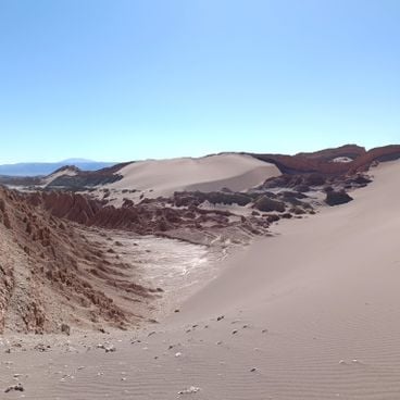
Jalapão, Brazil
This natural pool in Jalapão is fed by underground springs whose upward flow keeps swimmers afloat at the surface. The clear water rises through sandy substrate, creating a natural buoyancy effect. Fervedouro Bela Vista is among the natural formations found in the Jalapão region, a remote area in central west Brazil known for its waterfalls, caves and geological features. Visitors can experience the constant upward current that holds anyone at the water's surface.

Alto Paraíso de Goiás, Brazil
This two-tiered waterfall sits within Chapada dos Veadeiros National Park, a protected area in central west Brazil known for extensive savanna landscapes and geological formations. Water drops approximately 150 feet (45 m) over rock ledges into a wide natural pool deep enough for swimming. Vegetation around Almécegas Waterfall consists of typical cerrado plants, including low trees with twisted trunks and various grasses. Access requires a walk of roughly 1.2 miles (2 km) along unpaved trails through the protected area.

Mato Grosso do Sul, Brazil
Serra da Bodoquena National Park sits in the southern part of Mato Grosso do Sul state and protects a landscape of limestone formations, rivers and caves. As part of central west Brazil's natural locations, this park forms a corridor between the Pantanal wetlands and the Atlantic Forest. The rivers emerge from the hills and flow over tufa terraces. The caves host populations of bats and invertebrates. Vegetation includes dry forests and gallery forests along the watercourses.

Chapada dos Veadeiros, Brazil
This waterfall drops 130 feet (40 meters) into a canyon within Chapada dos Veadeiros National Park, one of the main protected areas in the Central West region. The rocks surrounding Cachoeira do Abismo provide views of the forested valley below and the surrounding plateaus. Access is via trails through cerrado vegetation, known for its biodiversity. The area is part of one of the oldest geological formations in Brazil.

Pirenópolis, Brazil
This granite boulder rises 20 meters (66 feet) above the cerrado grassland near Pirenópolis, balanced on a narrow base that gives it the appearance of a giant balloon. Pedra Balão is part of the Serra dos Pireneus, a mountain range containing several geological formations shaped by millions of years of erosion. The rock sits about 25 kilometers (16 miles) from the historic town center and is reached via unpaved roads and walking trails. The surrounding area offers views of the savanna landscape and other rock formations that define the highlands of this central west region of Brazil.

Bonito, Brazil
This 236-foot (72-meter) deep cave forms part of the natural attractions in central west Brazil and contains an underground lake with stalactites. Visitors can rappel down through the opening or dive in the clear waters of the lake. Abismo Anhumas sits in the Bonito region, known for its karst formations and freshwater systems. The cave provides access to a geological system that has developed over thousands of years.

Jalapão, Brazil
This waterfall formation in Jalapão represents one of the natural attractions in central west Brazil. The Cachoeira do Formiga drops 20 feet (6 meters) into a turquoise pool surrounded by Cerrado vegetation. The site sits within an area that contains additional geological formations, caves and underground rivers characteristic of the central savanna region.

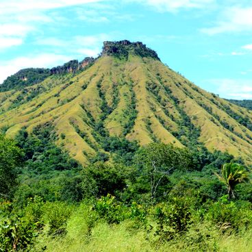
Chapada dos Guimarães, Brazil
This national park covers roughly 33,000 hectares (82,000 acres) and ranks among the most geologically notable natural sites in central west Brazil. Red sandstone cliffs rise to heights of approximately 2,600 feet (800 meters), forming dramatic escarpments above the surrounding savanna. Several waterfalls cut through the park, including the Véu de Noiva, which drops 280 feet (86 meters). Vegetation alternates between cerrado savanna and gallery forests along watercourses. Trails lead to viewpoints, caves and rock inscriptions left by pre-Columbian peoples.

Chapada dos Guimarães, Brazil
This sandstone cave extends for around 4,600 feet (1,400 meters) and contains an underground lake with clear water. Aroe Jari Cave sits within the Chapada dos Guimarães region of central west Brazil, an area known for waterfalls, caves and underground rivers. The geological formations consist of red sandstone characteristic of this region. The underground lake inside the cave remains cool throughout the year and provides insight into the hydrological systems that shape this landscape. Access to the cave requires hiking through surrounding terrain and proper equipment for underground exploration.

Bom Jardim, Brazil
This lake in the Bom Jardim region serves as a gathering point for hundreds of red and blue macaws that arrive to drink and rest during the early morning and late afternoon hours. Macaw Lake sits in one of the more remote areas of central west Brazil and offers visitors the opportunity to observe the natural behavior of these large parrots in their native habitat. The birds appear in groups and use the water source regularly, with the best viewing times occurring during the twilight hours when the animals are most active and their bright plumage is most visible against the surrounding landscape.

Capitólio, Brazil
This 66-foot (20-meter) waterfall in central west Brazil features natural pools for swimming and rock walls for climbing. Capivara Waterfall sits in a region known for its geological formations and waterways. The area around the falls is part of the natural attractions in the Central West region, where colonial towns, archaeological sites and national parks with diverse wildlife are located.

Mato Grosso, Brazil
This waterfall divides into seven separate cascades over basalt formations in the Brazilian Cerrado grassland. The Sete Quedas falls reach a combined height of 295 feet (90 meters) and lie in a region of Mato Grosso state known for its geological formations and water features. Access to this remote natural site requires several hours of driving from major towns and passes through typical Cerrado vegetation with open grasslands and scattered trees. The basalt layers over which the water flows formed through volcanic activity millions of years ago.

Mato Grosso, Brazil
This national park covers 135,000 hectares (333,590 acres) of marshes, lakes and rivers in Brazil's central west region. Pantanal National Park is home to 650 bird species and 80 mammal species across its wetland habitats. The protected area serves as critical habitat for jaguars, caimans, giant otters and capybaras. The reserve sits within one of the world's largest floodplains, where seasonal water level changes concentrate wildlife and facilitate observation.

Costa Rica, Brazil
This river flows through the region, forming rapids and sandbars along its course. The clear water of Rio Sucuriú allows observation of various freshwater fish species in their natural habitat. The river lies in a remote part of central west Brazil and offers visitors the opportunity to study the region's aquatic fauna. This waterway is part of the larger ecosystem that includes waterfalls, caves and protected natural areas.

Januária, Brazil
This national park protects an extensive cave system in the limestone mountains of Brazil's Central West region. The Peruaçu caves contain prehistoric rock paintings created by early human inhabitants. The limestone formations provide habitat for numerous bat species. The protected area lies in a remote location and preserves both archaeological heritage and natural cave ecosystems.