Brazil's Northeast region extends from the coast to the interior, connecting national parks, colonial towns and natural areas. The landscape shifts between coastal stretches, tablelands, river deltas and protected ecosystems. Geological formations, waterfalls and historic settlements mark the territory, which covers several Brazilian states.
Places in this collection include the white dunes and lagoons of Lençóis Maranhenses National Park in Maranhão, the Delta do Parnaíba along the Piauí coast, and the cliffs of Morro Branco in Ceará. Jericoacoara National Park protects coastal habitats and formations such as Pedra Furada. Inland, Chapada Diamantina National Park and Chapada das Mesas National Park in Bahia and Maranhão feature tablelands, caves and waterfalls including Cachoeira do Buracão. Serra da Capivara National Park in Piauí preserves prehistoric rock paintings, while Vale do Catimbau National Park in Pernambuco is marked by rock formations. The coastal zone offers the Fernando de Noronha Archipelago off Pernambuco, marine parks at Areia Vermelha and Praia de Calhetas, and the canyons of the São Francisco River between Alagoas and Sergipe. Colonial centers such as Olinda and the historic center of João Pessoa preserve architecture from earlier centuries.
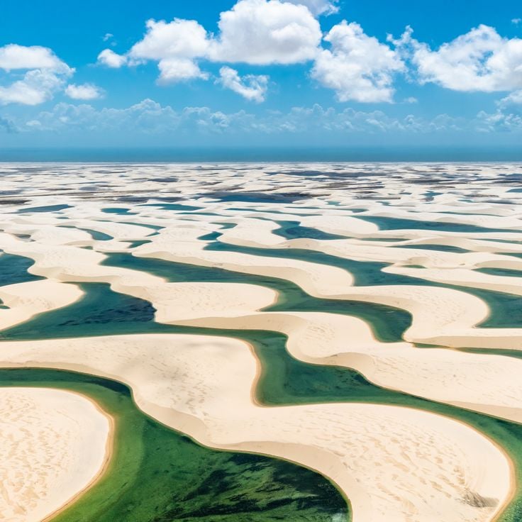
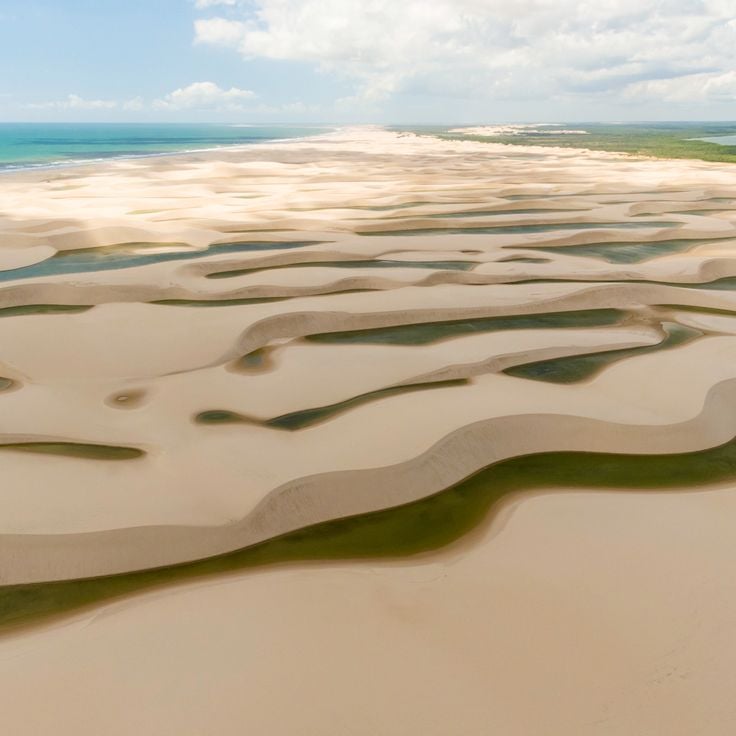
This national park in Maranhão state covers a large area and shows white sand carried by winds from the Atlantic into the interior. The dunes rise to heights of more than 50 meters (165 feet) and absorb fresh water during the rainy season, forming lagoons between the sand formations. From May through September, the water is most visible when the pools are full and create a contrast with the sand. People visit the park to walk through the dunes and swim in the lagoons, which vary in shape and location each year.
This delta forms where the Parnaíba River meets the Atlantic, creating over seventy islands between mangrove forests and sand banks. The water splits into multiple channels that wind through flat coastal land. At low tide, wide stretches of sand appear, while the mangroves shelter crabs and birds. Fishermen move between the islands in small boats, passing occasional houses built on stilts. The transition zones between fresh and salt water create habitats where land and sea blend daily.
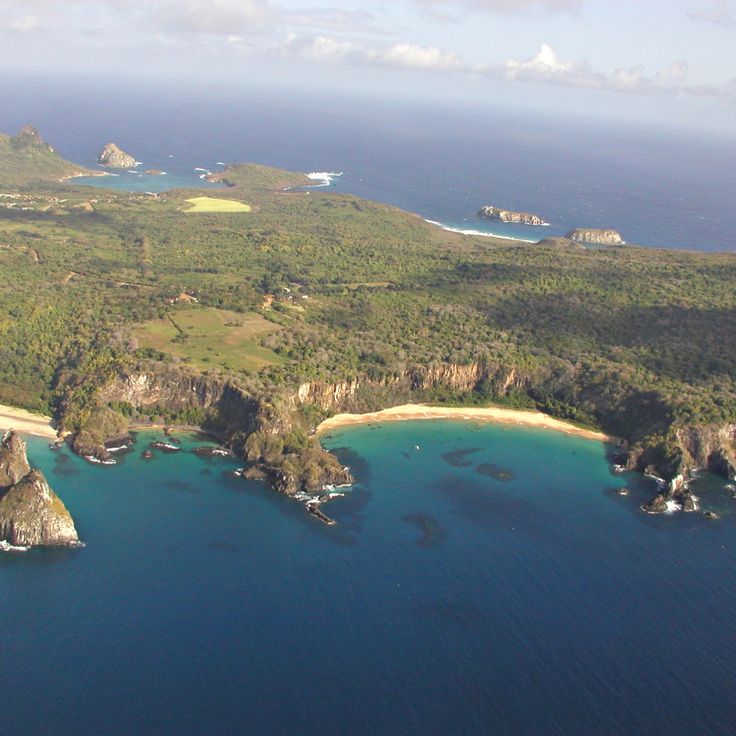
Fernando de Noronha Archipelago consists of 21 volcanic islands in the Atlantic Ocean off the coast of Pernambuco. The area is known for coral reefs, dolphins, sea turtles, and over 230 fish species. The islands form an important marine protected area and represent one of the natural treasures of northeastern Brazil.
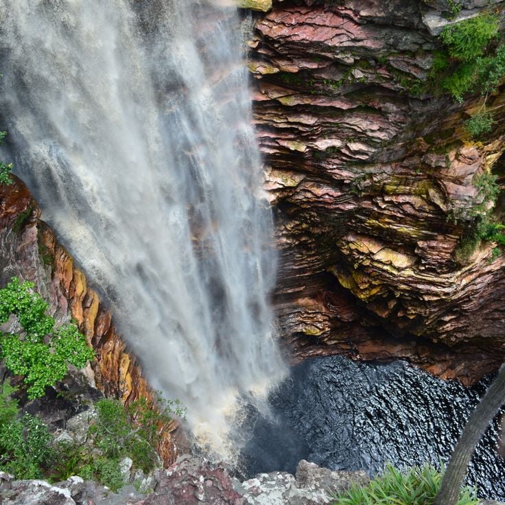
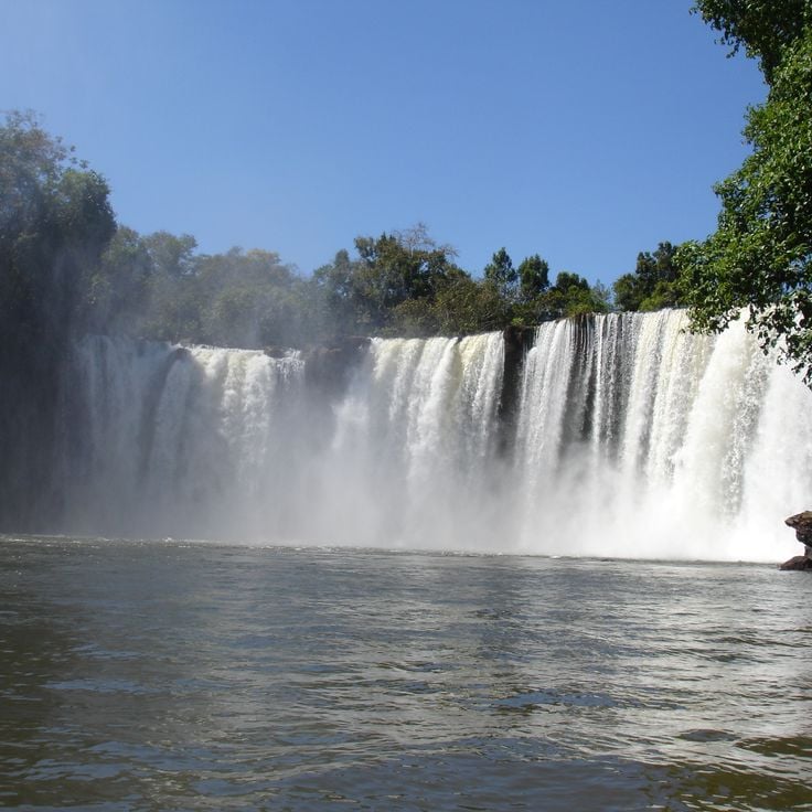
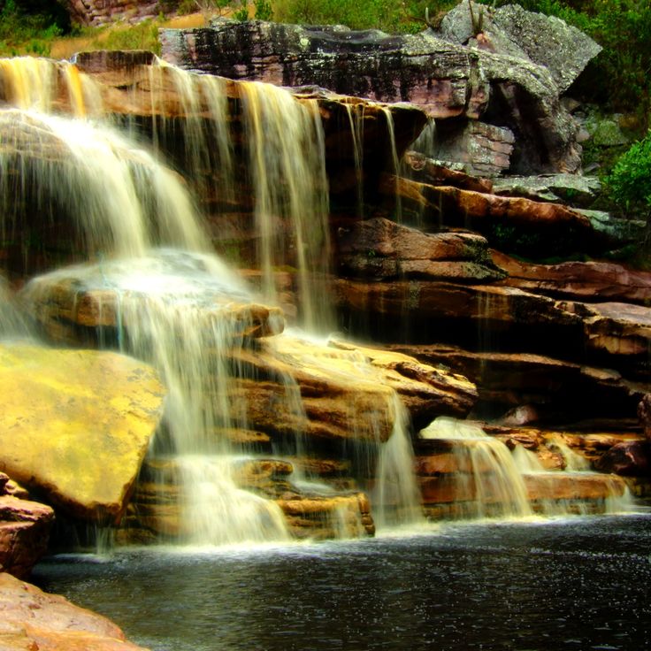
This waterfall in Bahia state drops 85 meters into a sandstone gorge where natural pools form at the base. The vertical rock walls frame the water and create a space where light hits the stone and reveals the shape of the canyon. Visitors can hike down to the bottom of the gorge and swim in the clear water of the pools. The trail passes through a landscape typical of the Bahia interior, with dry rock and low vegetation. The site is part of the collection of natural and cultural sites in northeast Brazil and shows the geological formations of the region. The gorge remains cool and shaded even when the sun is high above the plateau. The sound of falling water echoes between the walls.
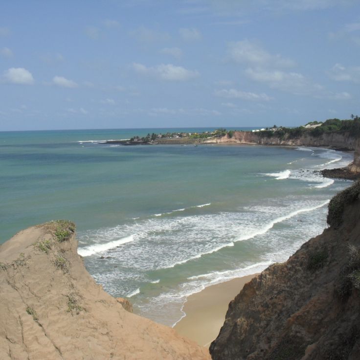
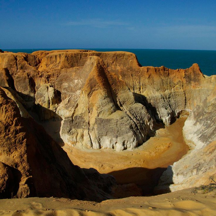
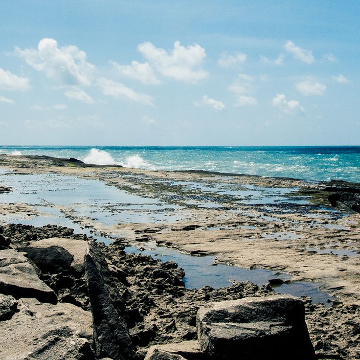
These cliffs of red and yellow sand shape the coast of Ceará for several kilometers, creating a geological window into the history of northeast Brazil. The formations show layers of different mineral composition, exposed by wind and water. Narrow paths run between the sandstone columns, where visitors observe the color contrasts and ongoing erosion. The sea continues to shape the base of the cliffs, while rain carves the upper sections.
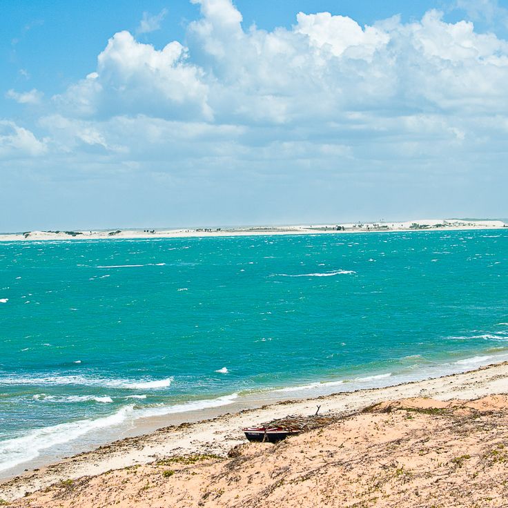
This national park covers 8,850 hectares (about 21,900 acres) of dunes, mangroves and lagoons along the coast. Jericoacoara is part of the natural landscapes in northeast Brazil and provides habitat for various coastal birds. The dunes form tall sand hills that shift with the wind. Between the dunes lie freshwater lagoons that invite swimming. The mangroves grow in sheltered areas near the sea. The park shows the typical coastal forms of this region with wide beaches and shallow lagoons. Birds nest in the mangroves and search for food near the water.
This cape marks the easternmost point of the American continent. A lighthouse stands over the ocean and an observation deck offers views across the Atlantic. The coastline here shows rock formations and beaches, where the water appears in different shades of blue. Visitors often arrive early in the morning to watch the sunrise, or in the afternoon for photographs. The lighthouse still serves navigation, and information panels explain the geographic importance of Ponta do Seixas among the natural and cultural sites of northeast Brazil.
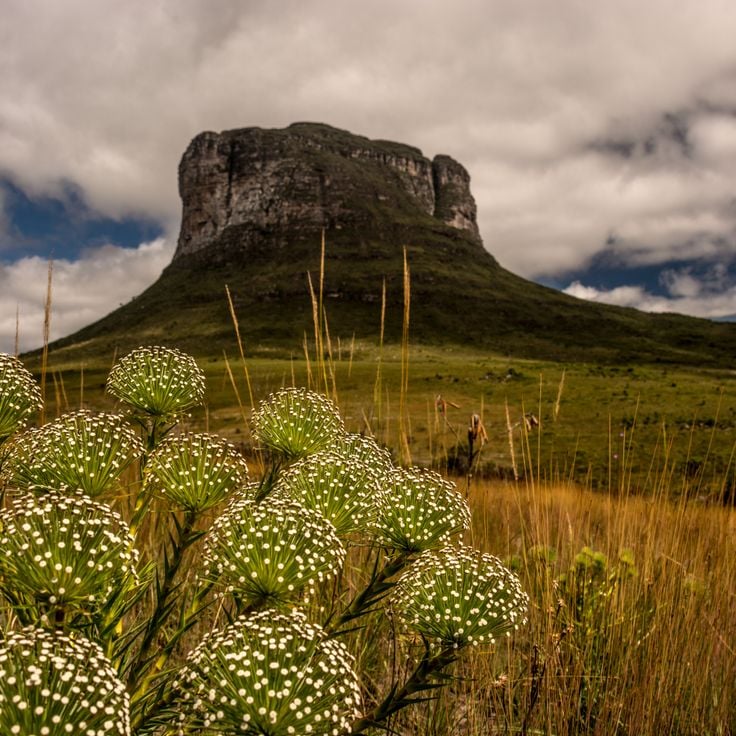
This national park in northeast Brazil covers 160,000 hectares of plateau mountains with rivers and waterfalls. The tablelands display red sandstone formations carved by erosion over time. Visitors can follow trails to natural pools and viewpoints across the terrain. Vegetation shifts between cerrado and wetter zones along watercourses. Chapada das Mesas sits away from major cities and attracts travelers who accept longer journeys to reach the area.
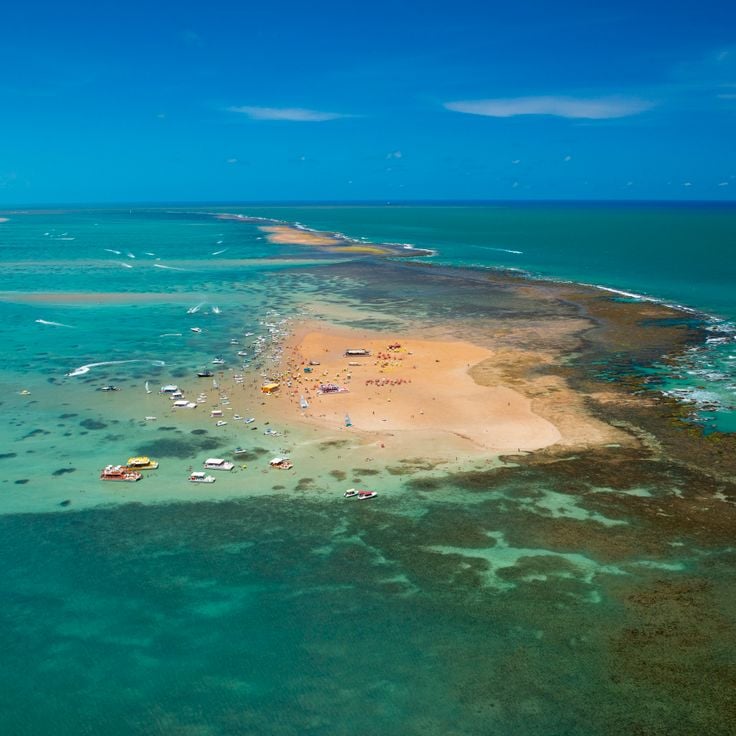
This marine park lies off the coast of Cabedelo and features a natural sandbank that emerges from the water twice daily during low tide. The sand strip extends for about a mile (1.5 kilometers) and is surrounded by coral reefs that become visible when the water recedes, forming a temporary island in the Atlantic.
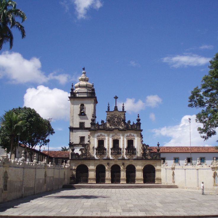
This historic center preserves 16th-century buildings with baroque churches, government structures and trading houses from the Portuguese colonial period, showing the development of João Pessoa as an early settlement along the northeastern coast of Brazil with broad plazas and facades that line streets from different eras.
This canyon follows the course of the Sao Francisco River, with rock walls that drop up to 560 feet (170 meters) below. The gorge runs for 25 miles (40 kilometers) through the Alagoas landscape, and boat tours move through narrower passages where the water flows quietly between steep cliffs. The rock faces show layers of sediment shaped over centuries by the river.
This 16th-century town stands on a hill above the sea and keeps the original layout of its streets. More than twenty baroque churches rise between colonial houses with colored facades and wooden shutters. Palm trees line the cobbled lanes that lead to squares with fountains and stone crosses. Portuguese tiles decorate the walls while carved doors and ironwork mark the entrances.
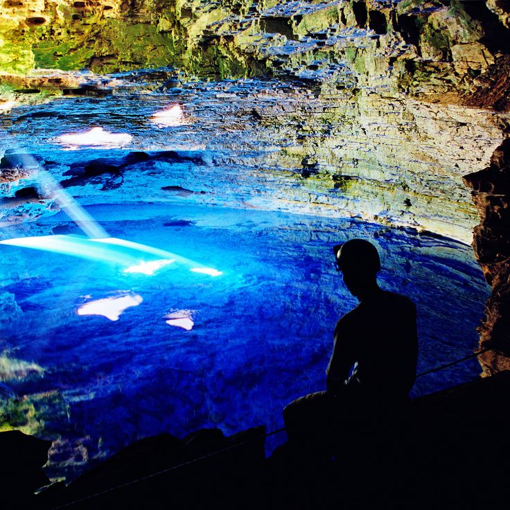
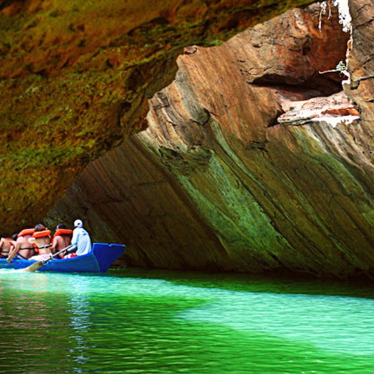
This underground lake sits inside a limestone cave in Chapada Diamantina and owes its turquoise color to rainwater filtered through the rock. Between April and September, rays of sunlight enter through an opening in the ceiling and illuminate the water in shades of blue. The cave lies about 200 feet (60 meters) below ground level. The light reaches the bottom of the lake, which is roughly 200 feet (61 meters) deep, making it one of the clearest underground bodies of water in Brazil. Visitors stand on platforms above the water and watch the reflections on the cave walls.
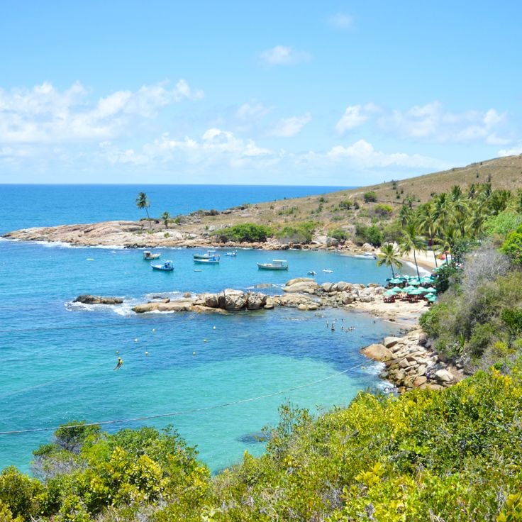
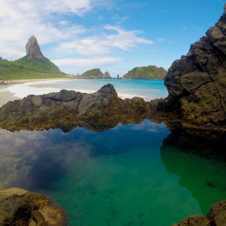
This bay sits between rocks on the Pernambuco coast, surrounded by dense Atlantic forest. The sand is pale and coconut palms line the shore. The water stays calm, sheltered by rock formations that rise on both sides. At low tide, natural pools form among the stones. Access follows narrow paths under tree cover, past roots and low shrub. The beach itself holds little development, just scattered huts. The water shifts from green to turquoise depending on light and depth. Locals come here to swim and fish.
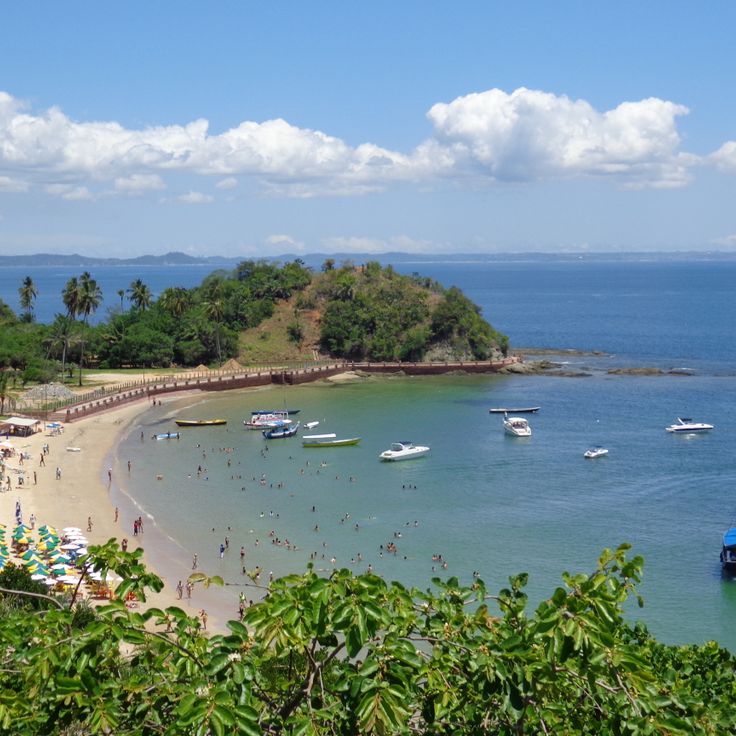
This island sits in Salvador's bay and contains tropical rainforest, sandy beaches and coral reefs. The water is warm and calm, many visitors come for swimming or diving among the corals. Small fishing villages are scattered along the coast. Boats travel regularly from the mainland. Paths run through dense forest, where birds and insects can be heard. Simple restaurants near the beach serve fresh fish.
This national park covers a mountain range with flat-topped peaks, deep valleys and cave systems. Rivers disappear into the rock and emerge elsewhere. Waterfalls drop over cliff edges into natural pools. Trails pass through forests and open highlands where erosion has exposed layers of sandstone. The park sits in Brazil's northeast interior.
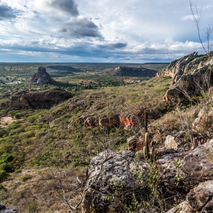
This national park displays sandstone walls with historical rock drawings from indigenous peoples. Vale do Catimbau shelters many rare plants and animals and sits in the dry inland of Pernambuco, where erosion has created distinct formations over thousands of years. The rock drawings tell stories of earlier inhabitants who lived in this area.
This national park in the northeast of Brazil preserves thousands of rock paintings from the Stone Age. The drawings show hunting scenes, dances and everyday actions of early inhabitants of the continent. Along with the painted rocks, Serra da Capivara contains excavation sites with skeletons of extinct animals and traces of human settlement that reach back several thousand years.
This national park in northeast Brazil protects rainforest sections and savanna areas across a mountain range that rises to 660 meters (2,165 feet) above sea level. The elevation creates different vegetation zones with forest patches, open grasslands and rock formations. Visitors walk trails through dense green areas and drier landscapes where plants grow lower and more sky becomes visible.
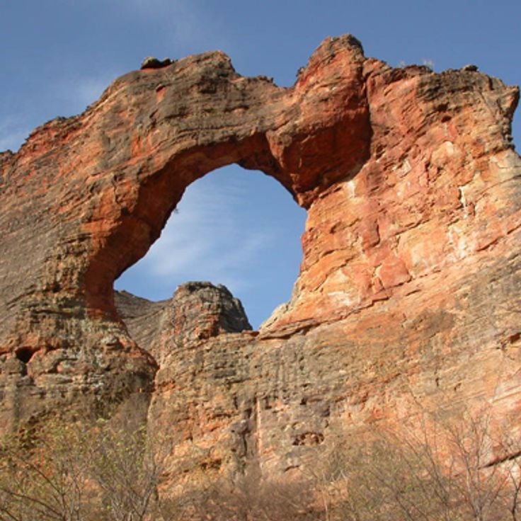
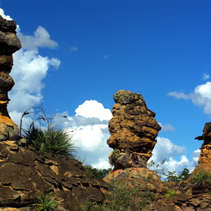
This national park contains red sandstone formations with natural arches and caves. The landscape alternates between grasslands and forested areas. The rocks display shades of red and ochre, shaped by erosion over time. Trails wind through the rock formations, passing rock faces and passages. Vegetation varies with the terrain, where open areas are interrupted by denser forest sections. The park sits in Brazil's Northeast region, which extends from coast to inland with colonial towns and natural areas.
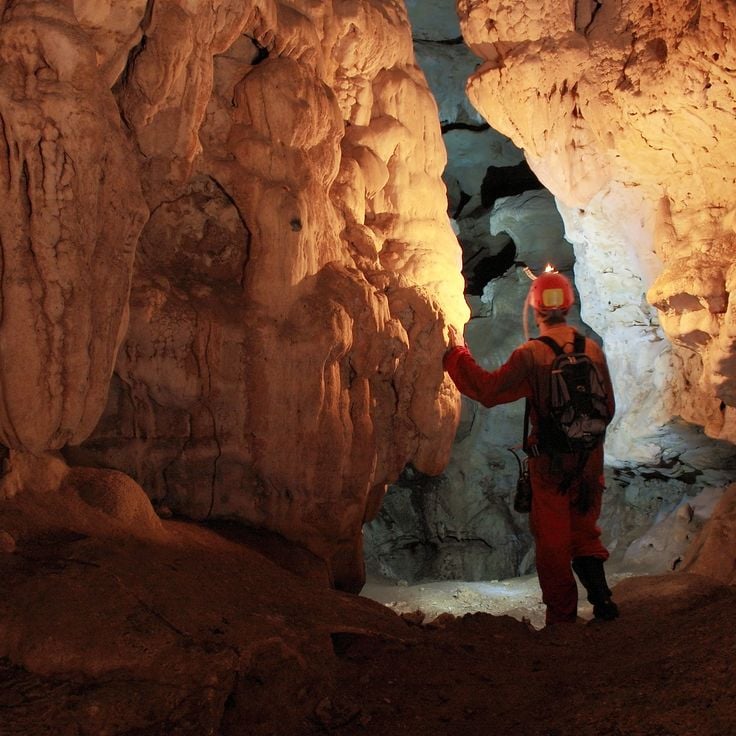
This national park protects 105 documented caves and rock walls within the typical Caatinga vegetation of northeastern Brazil. The underground formations in limestone developed over thousands of years through the slow dissolution of rock. Visitors can explore several caves that shelter bats and other animals adapted to darkness. The dry vegetation at the surface contrasts with the humid, cool interiors of the caves. Walking trails connect different entrances and pass through the dusty landscape of cacti and thorn bushes. Geologists study the cave systems to understand the development of this karst terrain.
This coastal headland lies south of Recife and brings together history and nature. Portuguese fortresses from the 16th century stand on cliffs overlooking the Atlantic. Sandy beaches draw visitors throughout the year. The natural harbor once served the sugar trade. Small fishing communities mark the area. The site forms part of the historical points of Brazil's Northeast and shows colonial traces alongside coastal vegetation.
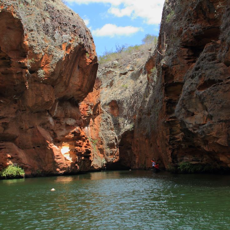
Xingó Canyon cuts up to 558 feet (170 meters) into the rock along the São Francisco River and runs for 40 miles (65 kilometers) through the border area between Alagoas and Sergipe. Steep walls of reddish and gray stone frame the river as it pushes through a narrow gorge. During a boat ride, you see the height of the walls and the layers in the rock that formed over millions of years. In some places, springs emerge from the walls, while in others, cacti and low bushes grow on the ledges. The river water is calm and greenish because it is regulated by the Sobradinho Dam farther north. This canyon is one of the geological formations in northeastern Brazil and sits far from the larger cities in a dry region.
These natural pools sit along a coastal stretch in Ceará, where rock formations have been shaped by the sea into shallow basins. At low tide, clear seawater collects between the stones, creating small bathing areas. Fish and other marine creatures typical of the northeastern Brazilian coast swim in these pools. The rock underfoot is dark volcanic stone. Visitors come to wade and observe the underwater life. The pools lie close to the beach and can be reached on foot.
This research station works to protect sea turtles along the Brazilian coast. The Tamar Project welcomes visitors who can watch injured or sick animals receiving treatment and learn about breeding programs. Tanks hold turtles of different species being cared for before release back into the ocean. Information panels explain the life cycles of these reptiles and the threats they face in the wild. The beach in front of the station sometimes serves as a natural nesting site, and biologists patrol at night to protect egg clutches. This station is part of a network of facilities across northeast Brazil that has operated since the 1980s. Children can join feeding sessions and learn how fishing nets and gear harm turtles. A small shop sells souvenirs with proceeds supporting conservation work.
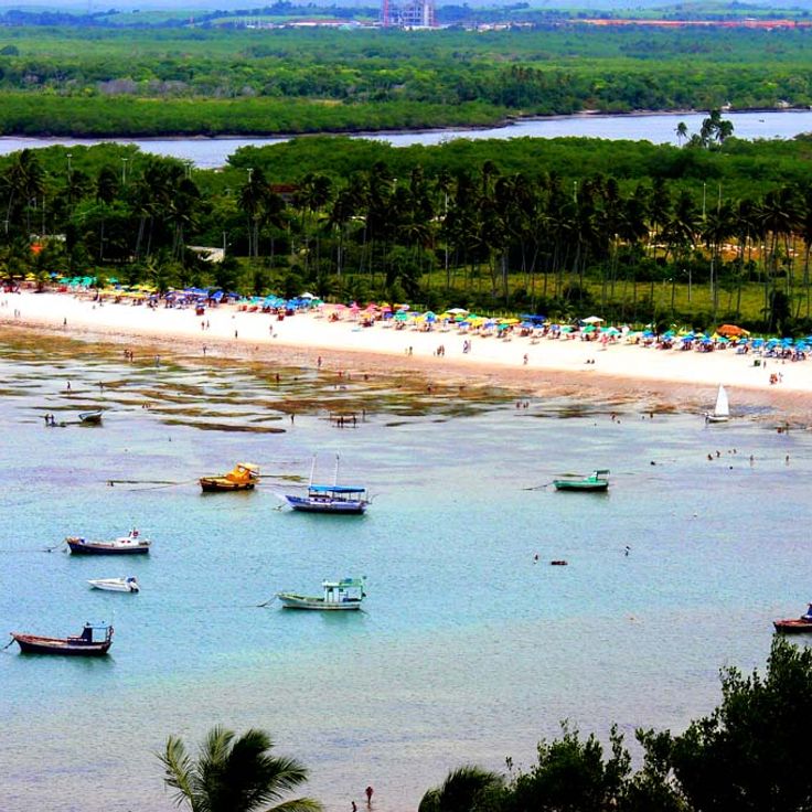
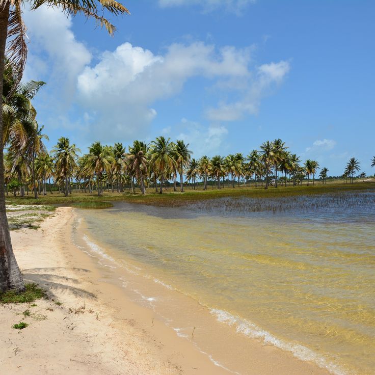
This beach joins mangrove forests to the open ocean, where freshwater from inland rivers meets the Atlantic. Praia Bela sits along a stretch of coastline in northeast Brazil where tidal channels wind through the green of the mangroves. The water shifts from clear and calm in protected areas to livelier at the open sea. Fishermen use the estuary zones, while visitors walk along the shoreline between the two worlds. The landscape shows the interplay of river and sea typical of this region.
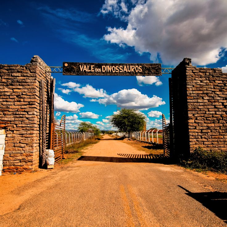
This paleontological site preserves fossilized footprints of various dinosaur species in rock formations from the Cretaceous period. At Vale dos Dinossauros, part of Brazil's coastal region, visitors can observe traces left by theropods, sauropods and other prehistoric reptiles that walked through this area roughly 80 million years ago. The prints are embedded in sedimentary rock and show different sizes and shapes. This site documents a time when the area had a different climate and living conditions. Access is through pathways leading to the well-preserved prints, where information panels provide context about the geological history.
This natural pool sits inside a limestone cave in Pernambuco and belongs to the geological formations of Brazil's northeastern coastal region. The water in this cave is clear enough for swimming, and the rock formations on the walls show the limestone layers created by centuries of erosion. Visitors descend into the cave to swim in the pool, which is lit by natural light filtering through openings above.
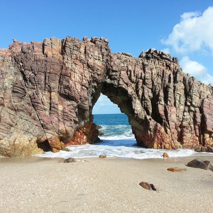
This natural rock arch on the beach formed over centuries through erosion by wind and water. The path crosses sand dunes and offers views of the coast. Many visitors come at sunset, when light passes through the opening in the rock. The formation is part of the coastal landscape of Jericoacoara and belongs to the geological features of Brazil's northeast coast.
This beach lies on the northeastern coast of Rio Grande do Norte, where natural depressions in the rock hold seawater after the tide goes out. Camurupim Beach sits among volcanic formations that shape the coastline and create shallow pools each time the water retreats. Visitors walk between the rocks at low tide to explore these temporary habitats filled with small marine life. The stone formations provide shade and divide the beach into sections. When the tide returns, most of the pools disappear under the waves again.
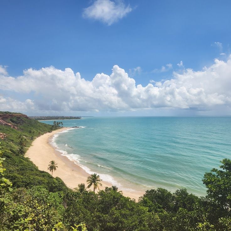
This beach stretches along the coast of Paraíba with red rock walls rising about 130 feet (40 meters). Coconut palms line the light sand along the Atlantic shore. The surroundings belong to the natural coastal areas of Northeast Brazil, where vegetation and geological formations meet. Visitors come here to experience the open beaches and the rock landscape typical of this region.
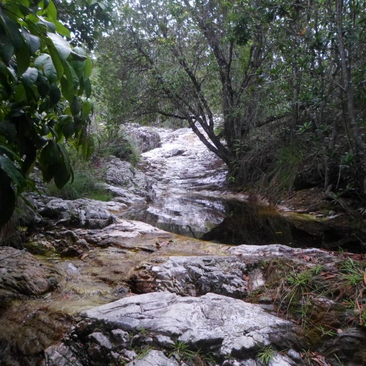
This waterfall drops about 20 meters (65 feet) over rock walls into a natural pool. The water collects at a depth of around three meters (10 feet) and forms a bathing area. The native vegetation of the Atlantic Forest surrounds the site and creates a shaded environment with dense plant growth. Visitors reach the pool along a trail through the forest. The water temperature remains cool year-round and the current is noticeable near the waterfall area. The site is part of the natural locations in Brazil's Northeast and shows the geology and vegetation of this region.
This volcanic archipelago lies 354 kilometers (220 miles) off the Brazilian coast and consists of 21 islands. Fernando de Noronha combines protected marine areas with warm, clear water where dolphins, sea turtles and coral reefs live. The islands are among the natural highlights of Brazil's northeast region, where beaches, rock formations and tropical vegetation come together. Walking trails lead along the coast and to viewpoints above the Atlantic.
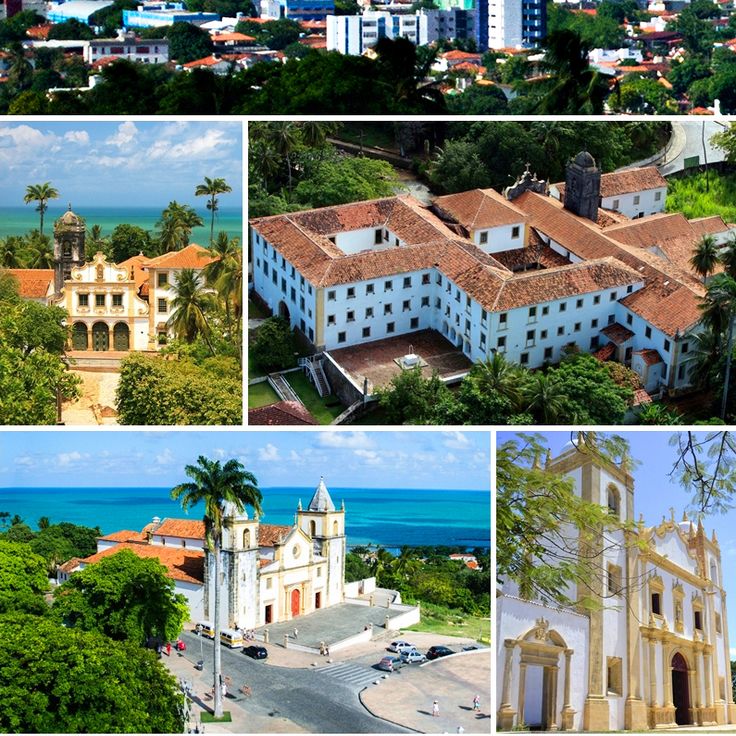
This 16th-century town preserves Portuguese colonial architecture and twenty baroque churches from different eras. Narrow lanes wind through historic quarters past facades painted in pale ochre, blue and rose. Olinda sits on a hillside overlooking the sea and the neighboring city of Recife. Streets are paved with cobblestone, and small squares open up at many corners with trees and benches. Art galleries, studios and cultural centers occupy old houses. During Carnival, the streets fill with music and dance, and the town becomes one large open celebration. Throughout the year, visitors come to walk the quiet lanes, step into the shade of church towers and experience the feeling of another time.
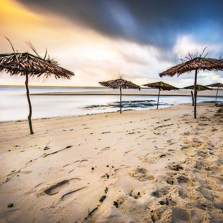
This national park on the coast of Ceará protects sand dunes that reach 30 meters (about 100 feet) and lagoons behind the beach. The former fishing village attracts windsurfers and kitesurfers who use the steady wind from the northeast. The dunes shift with the seasons, and the lagoons collect rainwater between the sandy rises. Palms line some paths, and the beach stretches for several kilometers. Visitors reach the area on unpaved roads that run through the dune landscape.
This national park in Maranhão state covers a large area and shows white sand carried by winds from the Atlantic into the interior. The dunes rise to heights of more than 50 meters (165 feet) and absorb fresh water during the rainy season, forming lagoons between the sand formations. From May through September, the water is most visible when the pools are full and create a contrast with the sand. People visit the park to walk through the dunes and swim in the lagoons, which vary in shape and location each year.
This delta forms where the Parnaíba River meets the Atlantic, creating over seventy islands between mangrove forests and sand banks. The water splits into multiple channels that wind through flat coastal land. At low tide, wide stretches of sand appear, while the mangroves shelter crabs and birds. Fishermen move between the islands in small boats, passing occasional houses built on stilts. The transition zones between fresh and salt water create habitats where land and sea blend daily.
Fernando de Noronha Archipelago consists of 21 volcanic islands in the Atlantic Ocean off the coast of Pernambuco. The area is known for coral reefs, dolphins, sea turtles, and over 230 fish species. The islands form an important marine protected area and represent one of the natural treasures of northeastern Brazil.
This waterfall in Bahia state drops 85 meters into a sandstone gorge where natural pools form at the base. The vertical rock walls frame the water and create a space where light hits the stone and reveals the shape of the canyon. Visitors can hike down to the bottom of the gorge and swim in the clear water of the pools. The trail passes through a landscape typical of the Bahia interior, with dry rock and low vegetation. The site is part of the collection of natural and cultural sites in northeast Brazil and shows the geological formations of the region. The gorge remains cool and shaded even when the sun is high above the plateau. The sound of falling water echoes between the walls.
These cliffs of red and yellow sand shape the coast of Ceará for several kilometers, creating a geological window into the history of northeast Brazil. The formations show layers of different mineral composition, exposed by wind and water. Narrow paths run between the sandstone columns, where visitors observe the color contrasts and ongoing erosion. The sea continues to shape the base of the cliffs, while rain carves the upper sections.
This national park covers 8,850 hectares (about 21,900 acres) of dunes, mangroves and lagoons along the coast. Jericoacoara is part of the natural landscapes in northeast Brazil and provides habitat for various coastal birds. The dunes form tall sand hills that shift with the wind. Between the dunes lie freshwater lagoons that invite swimming. The mangroves grow in sheltered areas near the sea. The park shows the typical coastal forms of this region with wide beaches and shallow lagoons. Birds nest in the mangroves and search for food near the water.
This cape marks the easternmost point of the American continent. A lighthouse stands over the ocean and an observation deck offers views across the Atlantic. The coastline here shows rock formations and beaches, where the water appears in different shades of blue. Visitors often arrive early in the morning to watch the sunrise, or in the afternoon for photographs. The lighthouse still serves navigation, and information panels explain the geographic importance of Ponta do Seixas among the natural and cultural sites of northeast Brazil.
This national park in northeast Brazil covers 160,000 hectares of plateau mountains with rivers and waterfalls. The tablelands display red sandstone formations carved by erosion over time. Visitors can follow trails to natural pools and viewpoints across the terrain. Vegetation shifts between cerrado and wetter zones along watercourses. Chapada das Mesas sits away from major cities and attracts travelers who accept longer journeys to reach the area.
This marine park lies off the coast of Cabedelo and features a natural sandbank that emerges from the water twice daily during low tide. The sand strip extends for about a mile (1.5 kilometers) and is surrounded by coral reefs that become visible when the water recedes, forming a temporary island in the Atlantic.
This historic center preserves 16th-century buildings with baroque churches, government structures and trading houses from the Portuguese colonial period, showing the development of João Pessoa as an early settlement along the northeastern coast of Brazil with broad plazas and facades that line streets from different eras.
This canyon follows the course of the Sao Francisco River, with rock walls that drop up to 560 feet (170 meters) below. The gorge runs for 25 miles (40 kilometers) through the Alagoas landscape, and boat tours move through narrower passages where the water flows quietly between steep cliffs. The rock faces show layers of sediment shaped over centuries by the river.
This 16th-century town stands on a hill above the sea and keeps the original layout of its streets. More than twenty baroque churches rise between colonial houses with colored facades and wooden shutters. Palm trees line the cobbled lanes that lead to squares with fountains and stone crosses. Portuguese tiles decorate the walls while carved doors and ironwork mark the entrances.
This underground lake sits inside a limestone cave in Chapada Diamantina and owes its turquoise color to rainwater filtered through the rock. Between April and September, rays of sunlight enter through an opening in the ceiling and illuminate the water in shades of blue. The cave lies about 200 feet (60 meters) below ground level. The light reaches the bottom of the lake, which is roughly 200 feet (61 meters) deep, making it one of the clearest underground bodies of water in Brazil. Visitors stand on platforms above the water and watch the reflections on the cave walls.
This bay sits between rocks on the Pernambuco coast, surrounded by dense Atlantic forest. The sand is pale and coconut palms line the shore. The water stays calm, sheltered by rock formations that rise on both sides. At low tide, natural pools form among the stones. Access follows narrow paths under tree cover, past roots and low shrub. The beach itself holds little development, just scattered huts. The water shifts from green to turquoise depending on light and depth. Locals come here to swim and fish.
This island sits in Salvador's bay and contains tropical rainforest, sandy beaches and coral reefs. The water is warm and calm, many visitors come for swimming or diving among the corals. Small fishing villages are scattered along the coast. Boats travel regularly from the mainland. Paths run through dense forest, where birds and insects can be heard. Simple restaurants near the beach serve fresh fish.
This national park covers a mountain range with flat-topped peaks, deep valleys and cave systems. Rivers disappear into the rock and emerge elsewhere. Waterfalls drop over cliff edges into natural pools. Trails pass through forests and open highlands where erosion has exposed layers of sandstone. The park sits in Brazil's northeast interior.
This national park displays sandstone walls with historical rock drawings from indigenous peoples. Vale do Catimbau shelters many rare plants and animals and sits in the dry inland of Pernambuco, where erosion has created distinct formations over thousands of years. The rock drawings tell stories of earlier inhabitants who lived in this area.
This national park in the northeast of Brazil preserves thousands of rock paintings from the Stone Age. The drawings show hunting scenes, dances and everyday actions of early inhabitants of the continent. Along with the painted rocks, Serra da Capivara contains excavation sites with skeletons of extinct animals and traces of human settlement that reach back several thousand years.
This national park in northeast Brazil protects rainforest sections and savanna areas across a mountain range that rises to 660 meters (2,165 feet) above sea level. The elevation creates different vegetation zones with forest patches, open grasslands and rock formations. Visitors walk trails through dense green areas and drier landscapes where plants grow lower and more sky becomes visible.
This national park contains red sandstone formations with natural arches and caves. The landscape alternates between grasslands and forested areas. The rocks display shades of red and ochre, shaped by erosion over time. Trails wind through the rock formations, passing rock faces and passages. Vegetation varies with the terrain, where open areas are interrupted by denser forest sections. The park sits in Brazil's Northeast region, which extends from coast to inland with colonial towns and natural areas.
This national park protects 105 documented caves and rock walls within the typical Caatinga vegetation of northeastern Brazil. The underground formations in limestone developed over thousands of years through the slow dissolution of rock. Visitors can explore several caves that shelter bats and other animals adapted to darkness. The dry vegetation at the surface contrasts with the humid, cool interiors of the caves. Walking trails connect different entrances and pass through the dusty landscape of cacti and thorn bushes. Geologists study the cave systems to understand the development of this karst terrain.
This coastal headland lies south of Recife and brings together history and nature. Portuguese fortresses from the 16th century stand on cliffs overlooking the Atlantic. Sandy beaches draw visitors throughout the year. The natural harbor once served the sugar trade. Small fishing communities mark the area. The site forms part of the historical points of Brazil's Northeast and shows colonial traces alongside coastal vegetation.
Xingó Canyon cuts up to 558 feet (170 meters) into the rock along the São Francisco River and runs for 40 miles (65 kilometers) through the border area between Alagoas and Sergipe. Steep walls of reddish and gray stone frame the river as it pushes through a narrow gorge. During a boat ride, you see the height of the walls and the layers in the rock that formed over millions of years. In some places, springs emerge from the walls, while in others, cacti and low bushes grow on the ledges. The river water is calm and greenish because it is regulated by the Sobradinho Dam farther north. This canyon is one of the geological formations in northeastern Brazil and sits far from the larger cities in a dry region.
These natural pools sit along a coastal stretch in Ceará, where rock formations have been shaped by the sea into shallow basins. At low tide, clear seawater collects between the stones, creating small bathing areas. Fish and other marine creatures typical of the northeastern Brazilian coast swim in these pools. The rock underfoot is dark volcanic stone. Visitors come to wade and observe the underwater life. The pools lie close to the beach and can be reached on foot.
This research station works to protect sea turtles along the Brazilian coast. The Tamar Project welcomes visitors who can watch injured or sick animals receiving treatment and learn about breeding programs. Tanks hold turtles of different species being cared for before release back into the ocean. Information panels explain the life cycles of these reptiles and the threats they face in the wild. The beach in front of the station sometimes serves as a natural nesting site, and biologists patrol at night to protect egg clutches. This station is part of a network of facilities across northeast Brazil that has operated since the 1980s. Children can join feeding sessions and learn how fishing nets and gear harm turtles. A small shop sells souvenirs with proceeds supporting conservation work.
This beach joins mangrove forests to the open ocean, where freshwater from inland rivers meets the Atlantic. Praia Bela sits along a stretch of coastline in northeast Brazil where tidal channels wind through the green of the mangroves. The water shifts from clear and calm in protected areas to livelier at the open sea. Fishermen use the estuary zones, while visitors walk along the shoreline between the two worlds. The landscape shows the interplay of river and sea typical of this region.
This paleontological site preserves fossilized footprints of various dinosaur species in rock formations from the Cretaceous period. At Vale dos Dinossauros, part of Brazil's coastal region, visitors can observe traces left by theropods, sauropods and other prehistoric reptiles that walked through this area roughly 80 million years ago. The prints are embedded in sedimentary rock and show different sizes and shapes. This site documents a time when the area had a different climate and living conditions. Access is through pathways leading to the well-preserved prints, where information panels provide context about the geological history.
This natural pool sits inside a limestone cave in Pernambuco and belongs to the geological formations of Brazil's northeastern coastal region. The water in this cave is clear enough for swimming, and the rock formations on the walls show the limestone layers created by centuries of erosion. Visitors descend into the cave to swim in the pool, which is lit by natural light filtering through openings above.
This natural rock arch on the beach formed over centuries through erosion by wind and water. The path crosses sand dunes and offers views of the coast. Many visitors come at sunset, when light passes through the opening in the rock. The formation is part of the coastal landscape of Jericoacoara and belongs to the geological features of Brazil's northeast coast.
This beach lies on the northeastern coast of Rio Grande do Norte, where natural depressions in the rock hold seawater after the tide goes out. Camurupim Beach sits among volcanic formations that shape the coastline and create shallow pools each time the water retreats. Visitors walk between the rocks at low tide to explore these temporary habitats filled with small marine life. The stone formations provide shade and divide the beach into sections. When the tide returns, most of the pools disappear under the waves again.
This beach stretches along the coast of Paraíba with red rock walls rising about 130 feet (40 meters). Coconut palms line the light sand along the Atlantic shore. The surroundings belong to the natural coastal areas of Northeast Brazil, where vegetation and geological formations meet. Visitors come here to experience the open beaches and the rock landscape typical of this region.
This waterfall drops about 20 meters (65 feet) over rock walls into a natural pool. The water collects at a depth of around three meters (10 feet) and forms a bathing area. The native vegetation of the Atlantic Forest surrounds the site and creates a shaded environment with dense plant growth. Visitors reach the pool along a trail through the forest. The water temperature remains cool year-round and the current is noticeable near the waterfall area. The site is part of the natural locations in Brazil's Northeast and shows the geology and vegetation of this region.
This volcanic archipelago lies 354 kilometers (220 miles) off the Brazilian coast and consists of 21 islands. Fernando de Noronha combines protected marine areas with warm, clear water where dolphins, sea turtles and coral reefs live. The islands are among the natural highlights of Brazil's northeast region, where beaches, rock formations and tropical vegetation come together. Walking trails lead along the coast and to viewpoints above the Atlantic.
This 16th-century town preserves Portuguese colonial architecture and twenty baroque churches from different eras. Narrow lanes wind through historic quarters past facades painted in pale ochre, blue and rose. Olinda sits on a hillside overlooking the sea and the neighboring city of Recife. Streets are paved with cobblestone, and small squares open up at many corners with trees and benches. Art galleries, studios and cultural centers occupy old houses. During Carnival, the streets fill with music and dance, and the town becomes one large open celebration. Throughout the year, visitors come to walk the quiet lanes, step into the shade of church towers and experience the feeling of another time.
This national park on the coast of Ceará protects sand dunes that reach 30 meters (about 100 feet) and lagoons behind the beach. The former fishing village attracts windsurfers and kitesurfers who use the steady wind from the northeast. The dunes shift with the seasons, and the lagoons collect rainwater between the sandy rises. Palms line some paths, and the beach stretches for several kilometers. Visitors reach the area on unpaved roads that run through the dune landscape.