See the monuments around you in AROpen chests in the app
Around Us is built for your phone — point your camera at the streets and discover the monuments and places around you in augmented reality.Around Us is built for your phone — chests unlock when you walk, explore and capture nearby places.
Natural landmarks of the Philippines for photography
The Philippines display rice terraces in Ifugao mountains, coral reefs in Tubbataha National Park, and cave systems in Samar. Mayon Volcano shows its geometric shape, while Chocolate Hills of Bohol extend across the landscape. White sand beaches line the coasts of Boracay and Palawan.
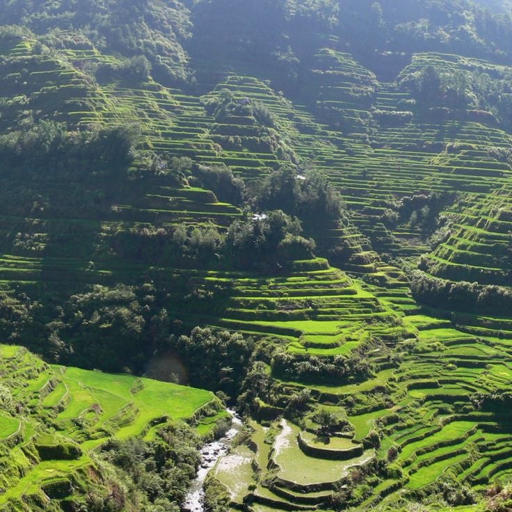
These 2000-year-old rice terraces stretch across 10000 square miles (26000 square kilometers) of Ifugao mountains and remain in use for local rice cultivation. The terraces demonstrate traditional agricultural practices of the region and provide photo opportunities with their tiered levels extending along mountain slopes. Walking paths lead through several terrace sections.
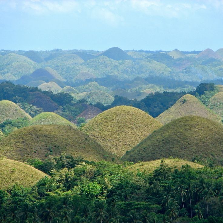
These uniform limestone hills span 50 square kilometers (19 square miles) across Bohol and turn brown during the dry season. Around 1,770 cone-shaped mounds define the landscape and form one of the geological features of the Philippines' natural terrain. The hills reach heights between 100 and 160 feet (30 and 50 meters) and display green vegetation during the rainy season that dries out in the dry months.
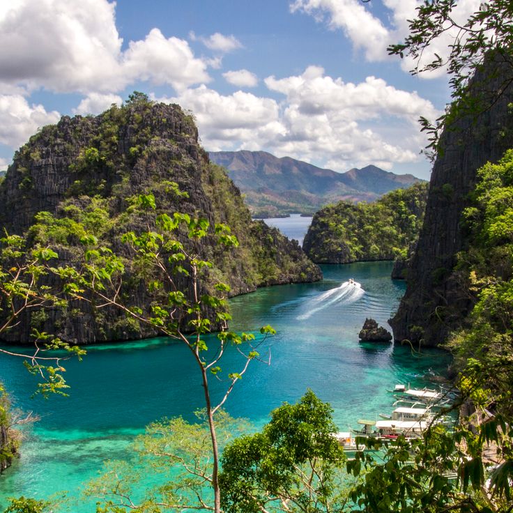
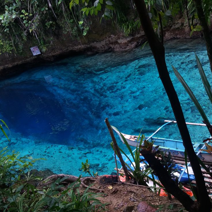
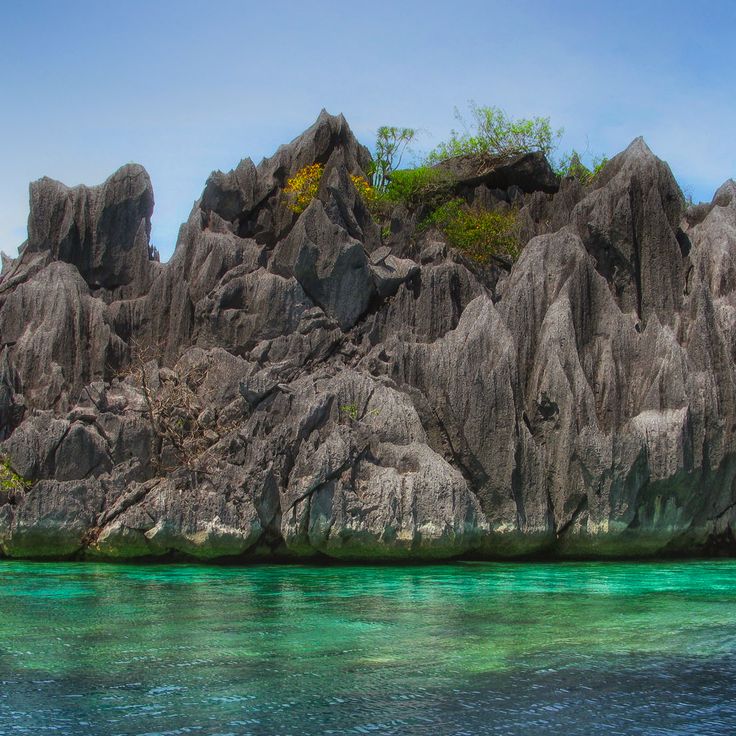
Kayangan Lake sits between steep limestone cliffs on Coron Island and reaches underwater visibility of around 70 percent. The freshwater body is fed by underground springs while the surrounding rock walls rise several hundred feet. Access follows a staircase of roughly 300 steps leading from the coast to the lake basin. Photographers find clear conditions for underwater shots and views of the geological formations that define Palawan's northern landscapes.
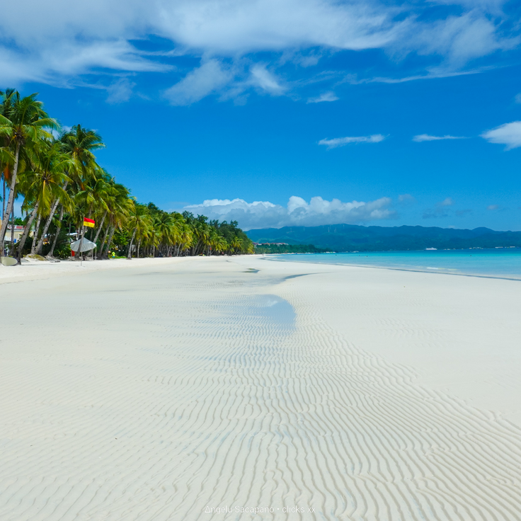
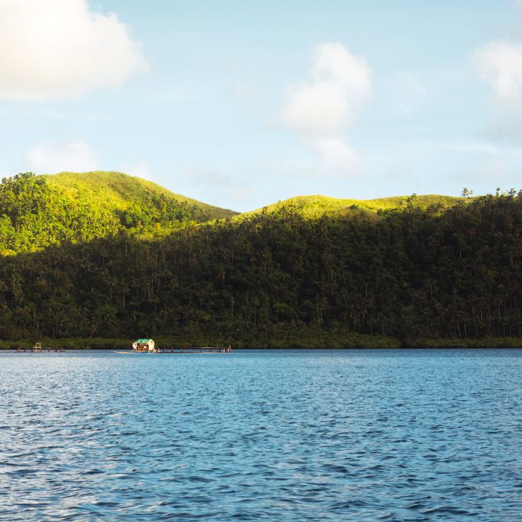
Plage Blanche extends for 2.5 miles (4 kilometers) along the western coast of Boracay, composed of fine white coral sand and lined with coconut palms. This coastal section forms part of the Philippine island landscapes and provides access to the Sulu Sea waters, while the palm groves offer natural shade along the shoreline.
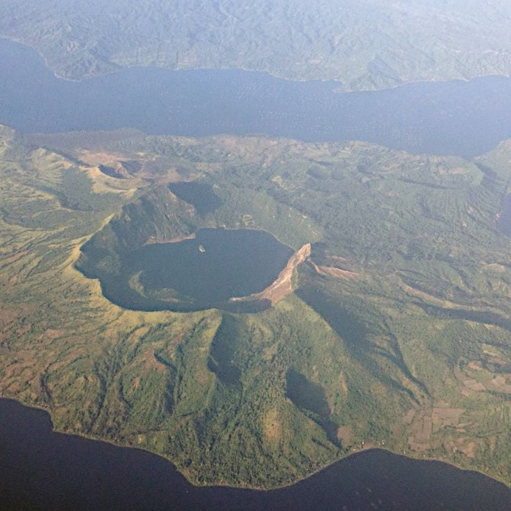
This volcano rises from an island in Taal Lake, about 31 miles (50 kilometers) south of Manila. The island volcano system spans roughly 9 miles (15 kilometers) across and shows clear evidence of eruptions from different periods. The crater lake at the summit sits about 984 feet (300 meters) above the surrounding lake. Black sand beaches along the lake shore result from past volcanic eruptions that have shaped the area over centuries.
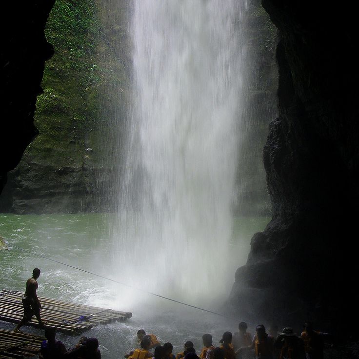
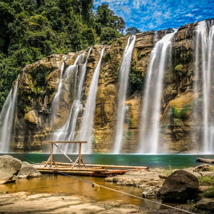
These waterfalls in northern Laguna drop 120 feet (37 meters) into a narrow gorge, creating a natural pool at their base. Visitors reach the Pagsanjan Falls via a two-hour upstream river journey, where local boatmen navigate bamboo rafts through tight passages between rock formations and over rapids. The limestone cliffs lining the riverbanks rise on both sides, forming a forested valley that narrows toward the fall zone, where water meets the basalt layer below.
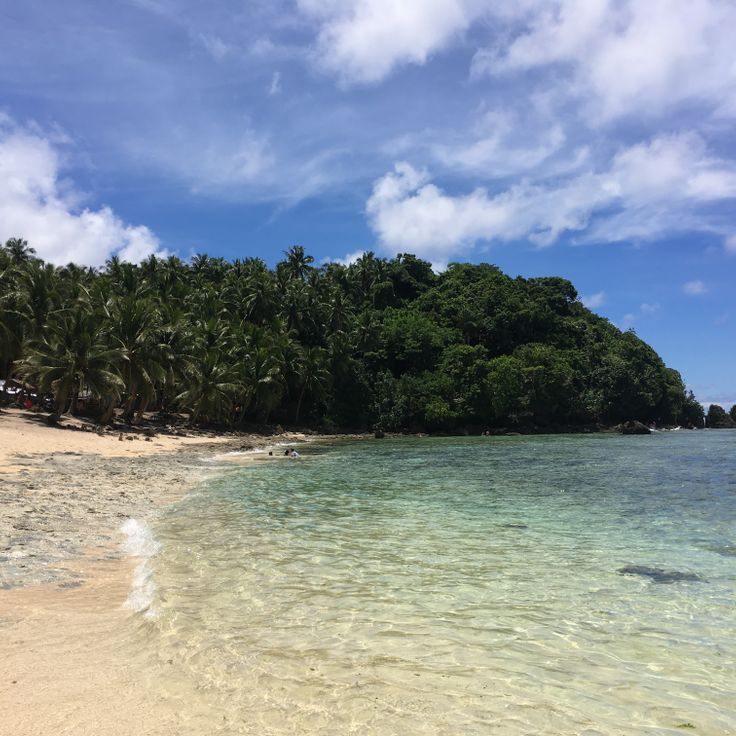
This island off the coast of Mindanao covers 437 square miles and combines surf conditions with mangrove forests and sand beaches. The Cloud 9 surf spot attracts surfers from different countries who find consistent waves of three to ten feet (one to three meters) throughout the year. The mangrove forests along the coast provide habitat for local bird species, while the beaches are lined with palm trees. Boat tours lead to surrounding islands and lagoons where visitors can swim and snorkel.
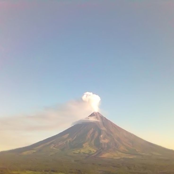
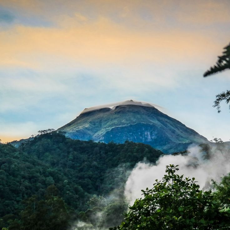
Mayon Volcano rises 8081 feet (2463 meters) above sea level and displays a nearly symmetrical cone shape. This stratovolcano remains active with regular eruptions that have shaped its appearance over centuries. The geometric profile resulted from repeated lava flows distributed evenly around the central vent, making it one of the most active volcanoes in the country.
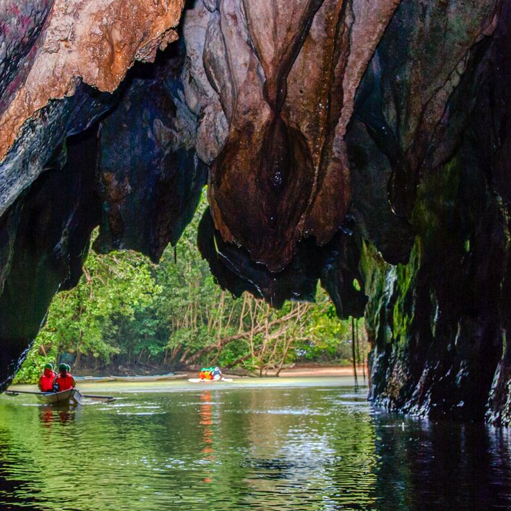
This underground river extends five miles (eight kilometers) through limestone caves with stalactites and stalagmites beneath the surface of Palawan. The cave system shelters colonies of bats and swiftlets. Visitors explore the waterway by boat through the upper sections of the cave, where rock formations have developed over thousands of years. The cave forms part of a larger national park that connects tropical forest with coastal areas.
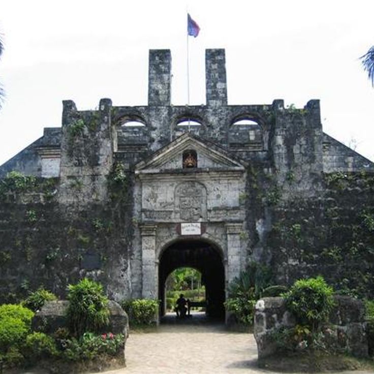
This triangular 16th-century fortress rises with 26-foot (8-meter) coral stone walls along the Cebu waterfront. The Spanish installation features three bastions and fourteen historic cannons positioned along the defensive perimeter. The fort served as a military base during colonial times and documents early Spanish presence in the Philippines, with preserved architecture providing insight into 16th-century fortification methods.
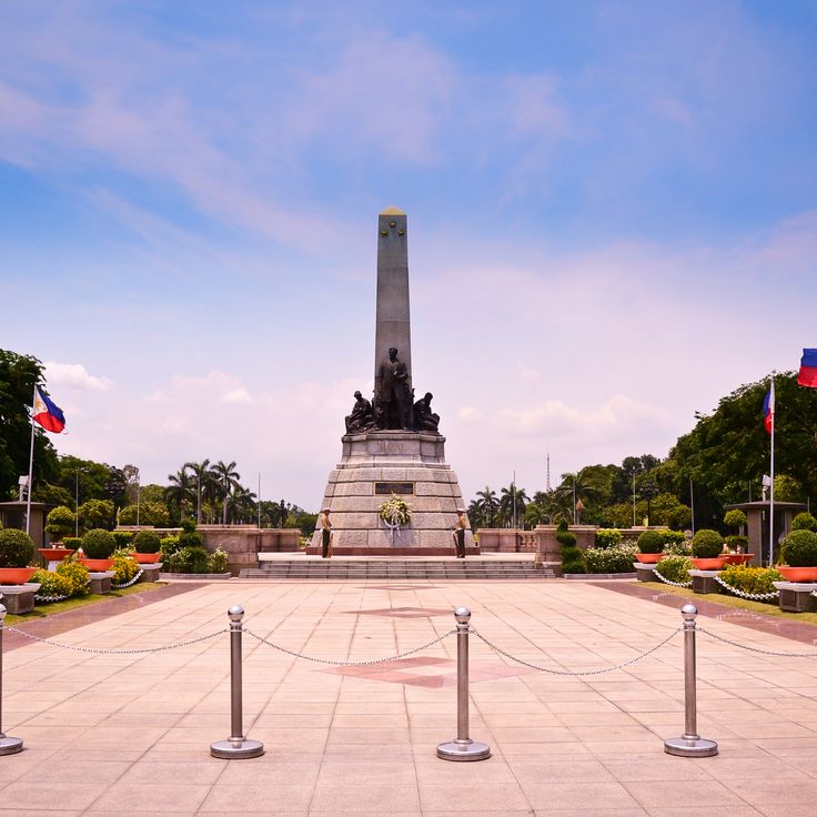
This 143-acre park preserves the site where José Rizal was executed in 1896 and combines gardens, monuments and museums into a space that documents Philippine history and brings together different aspects of national identity in the capital.
The Hinatuan Enchanted River emerges from an underground spring and flows directly into the Philippine Sea. Water depth reaches 260 feet (80 meters) in some sections. The clear water allows visibility to the riverbed at shallower depths. The river sits in Surigao del Sur and draws visitors who photograph the unusual waterway or swim in the upper reaches. The source itself remains largely unexplored.
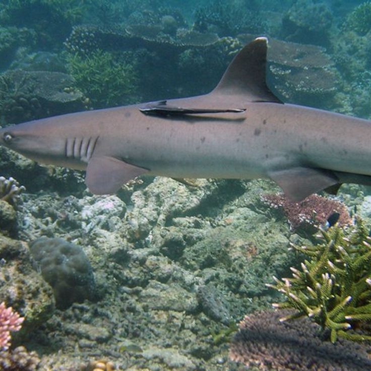
This marine park in the Sulu Sea covers more than 95,000 acres (38,600 hectares) and hosts 360 coral species and 600 fish species. The reefs lie roughly 110 miles (180 kilometers) southeast of Puerto Princesa and remain accessible only during the March to June season by liveaboard diving boats. The park provides nesting grounds for several sea turtle species and attracts sharks, manta rays and dolphins. Underwater visibility often reaches 100 feet (30 meters).
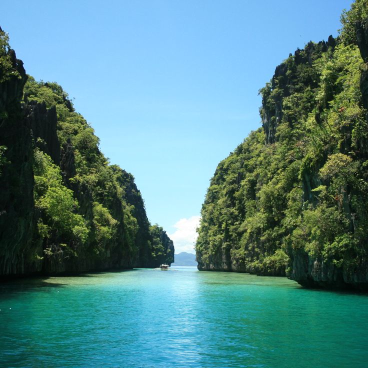
These two natural saltwater lagoons near El Nido sit among limestone formations and offer clear water for snorkeling and kayaking. Big Lagoon is accessed through a narrow channel, while Small Lagoon requires passage through a rock crevice. Both lagoons display the characteristic karst landscape of Bacuit Bay, with steep cliffs and turquoise water in protected coves.
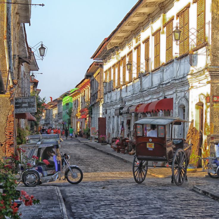
The Village du patrimoine de Vigan displays colonial Spanish architecture from the 16th century with stone houses, antique shops and traditional craft workshops. This historic town in the Philippines preserves its colonial structures along cobblestone streets where artisans still practice local techniques. The architectural consistency and ongoing craft tradition make this site a documentary subject for photographers capturing colonial heritage in Southeast Asia.
Mount Apo rises 9,692 feet (2,954 meters) above sea level, making it the highest peak in the Philippines. This volcano on Mindanao shelters various orchid species in its mountain forests, hot springs along its slopes, and serves as habitat for the Philippine eagle, one of the rarest birds of prey worldwide. The different elevation zones create multiple vegetation belts, from lowland rainforests to moss covered cloud forests near the summit. Hikers traverse sulfurous fumaroles and pass through areas of volcanic activity on their way up, reminders of the geological nature of this mountain.
This coastal zone in Palawan combines turquoise lagoons set between limestone cliffs with dive sites featuring Japanese shipwrecks from World War II. Coron Island offers photographers contrasts between sheltered bodies of water and historical underwater sites where warships rest at depths ranging from 33 to 131 feet (10 to 40 meters), now inhabited by coral formations and marine life.
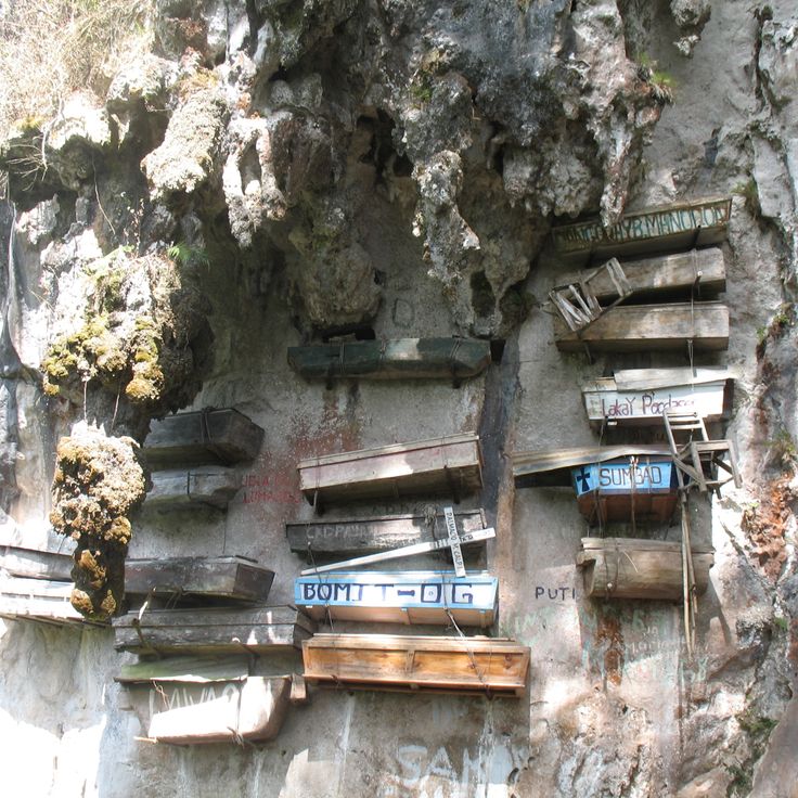
The hanging coffins of Sagada demonstrate a centuries-old burial tradition of the Igorot people. Wooden coffins were attached to limestone cliffs to position the deceased closer to the gods and protect them from flooding. This burial method continues to be practiced in some areas and offers insights into the spiritual beliefs of the Cordillera region's indigenous communities.
The Tinuy-an Falls drop 180 feet (55 meters) across four natural tiers and span roughly 310 feet (95 meters) in width. Located in the tropical rainforest of Surigao del Sur province, this waterfall ranks among the widest cascades in the country. The falling water creates a fine mist at the base, while the surrounding forest maintains dense vegetation of ferns and palm trees.
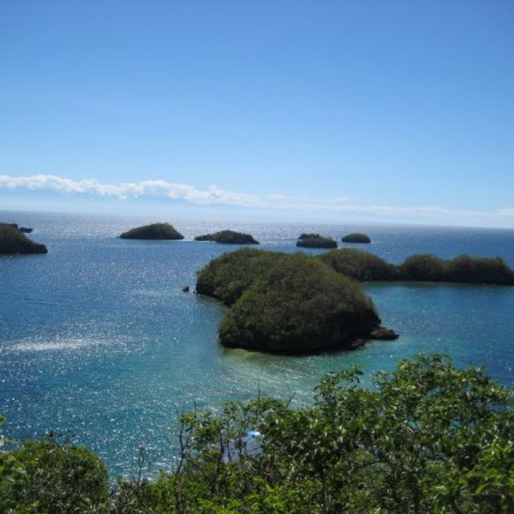
This national park encompasses 124 limestone islands in the Lingayen Gulf, known for their white sand beaches and coral reefs. The islands formed through volcanic activity and subsequent erosion over several millennia. The marine protected area hosts various coral species and tropical fish populations, while the islands themselves provide nesting grounds for seabirds and are covered with mangroves and coastal vegetation.
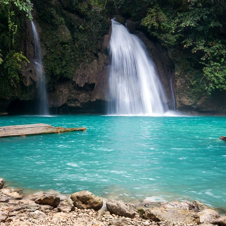
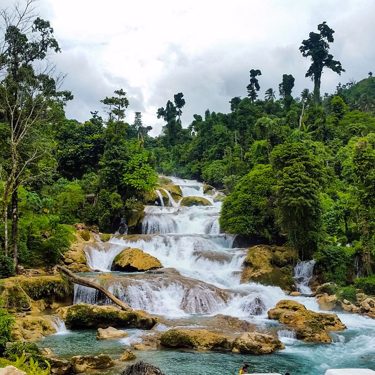
These three-tiered waterfalls in the rainforest feed turquoise pools supplied by underground springs. The river system flows through dense tropical vegetation on Cebu, providing access to multiple swimming areas. The main cascade drops roughly 130 feet (40 meters), creating natural pools suitable for photography. Trails connect the different levels along the river course.
This underwater cemetery off the coast of Camiguin has been submerged since 1871, when a volcanic eruption sank the original burial ground. A large white cross marks the location where graves once stood. The site serves as a diving spot where visitors can swim among sunken tombstones and observe the effects of volcanic activity in the region. The site sits in shallow water near the coast of Bonbon.
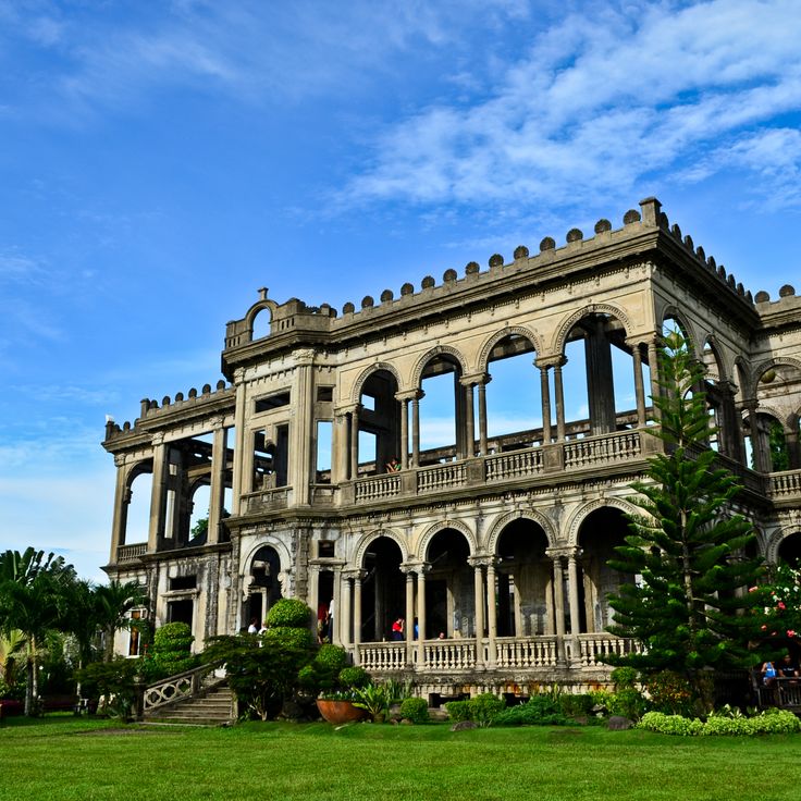
These ruins of an early 20th-century Italian-style mansion stand on the grounds of a former sugar plantation in Negros Occidental. American forces burned the structure in 1942 during World War II to prevent Japanese troops from using it as headquarters. The remaining columns, arches and coral stone walls provide a glimpse into colonial-era architecture and draw photographers who capture the structures against the sky, particularly at sunset.
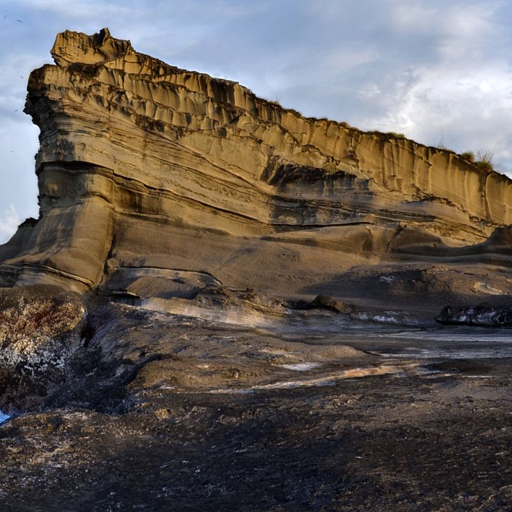
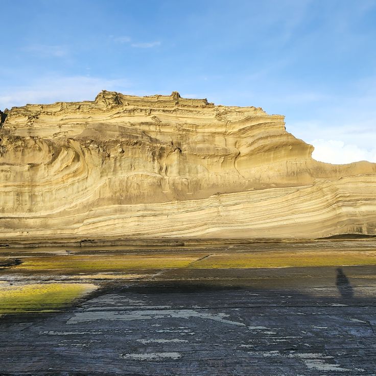
These rock formations rise along the northern coast of Biri Island and reach heights of up to 66 feet (20 meters). Pacific wind and waves have shaped seven distinct structures from the bedrock, spread across several coastal sections. The Magasang formation is considered the largest in the cluster, while Magsapad and Macadlaw face direct Pacific surf. Photographers use the tides for varying perspectives on the eroded surfaces and natural arches.
Bucas Grande sits in the Sigatoka archipelago and is known for its protected Sohoton Cove, where mangrove forests line karst-defined waters. The island hosts several species of non-stinging jellyfish in its brackish lagoons. Boat routes pass through narrow channels between limestone formations. Swimming areas are dictated by tidal cycles. Waters around the island provide access to additional small coves and cave entrances.
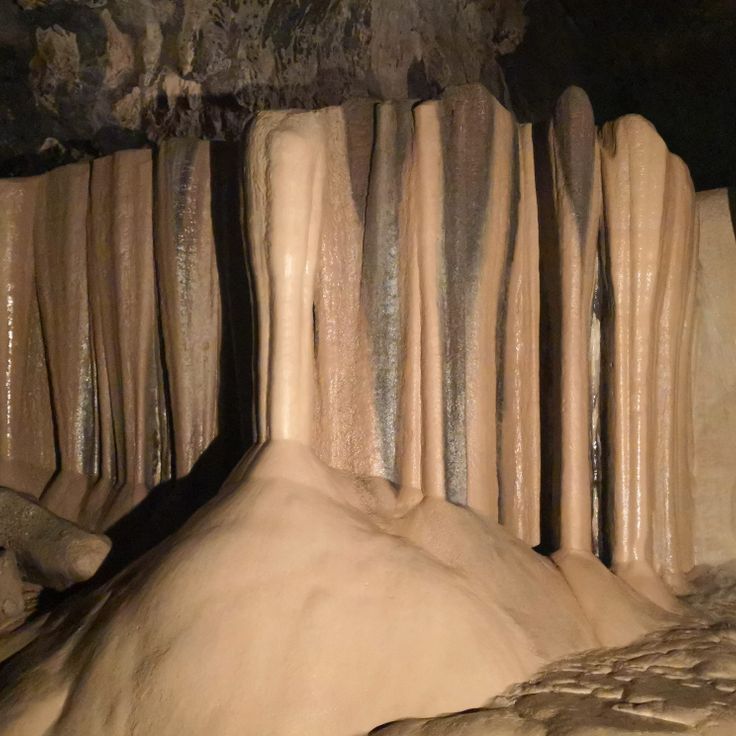
Sumaging Cave extends across 200 feet (60 meters) of vertical relief and forms the most extensive cave system in Sagada. Stalactites and stalagmites shape chambers reaching up to 60 feet (18 meters) in height, while flowstone terraces and drapery formations line the passages. The descent takes roughly two hours through narrow corridors and across smooth rock surfaces. An underground stream flows through the lower gallery, where natural pools have formed among limestone formations. Local guides accompany visitors through the technically demanding sections.
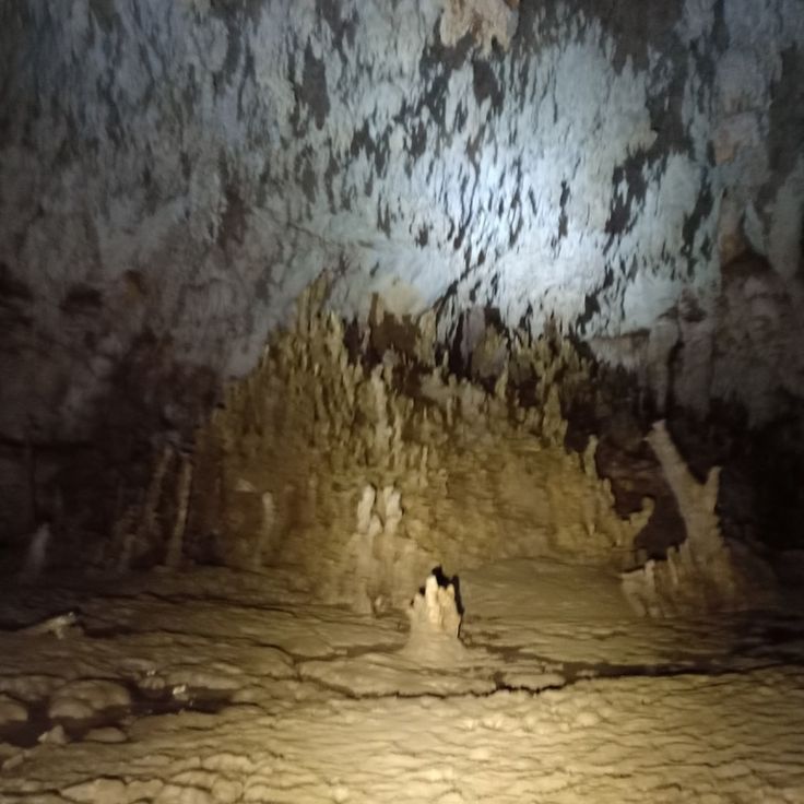
The Langun-Gobingob Caves form an extensive underground network spanning several miles and containing numerous chambers and geological formations. The system requires technical knowledge for exploring deeper sections, while surface-level areas remain accessible to less experienced visitors. These caves contain various mineral deposits and underground waterways that create opportunities for documenting subterranean environments.
The Aliwagwag Falls consist of over 80 cascades extending across a vertical distance of 1,115 feet (340 meters). This system sits in the highlands of Davao Oriental and offers trails through dense forest to various viewing points. Water flow varies between rainy and dry seasons.
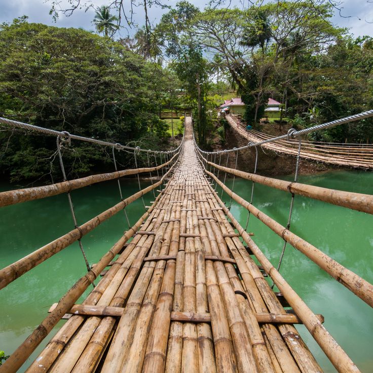
This 130-foot suspension bridge connects two communities across the Sipatan River in Bohol. The structure combines bamboo planks with steel cables. Photographers document the traditional engineering and the natural river landscape of the region. The construction provides perspectives on the forested banks and flowing water below.
The island contains the two-mile (3.2-kilometer) stretch of Mahabang Buhangin Beach, where fine white sand meets clear water. Tinaga sits within the Calaguas group and draws photographers documenting coastal landscapes and the gradual shoreline during daylight hours.
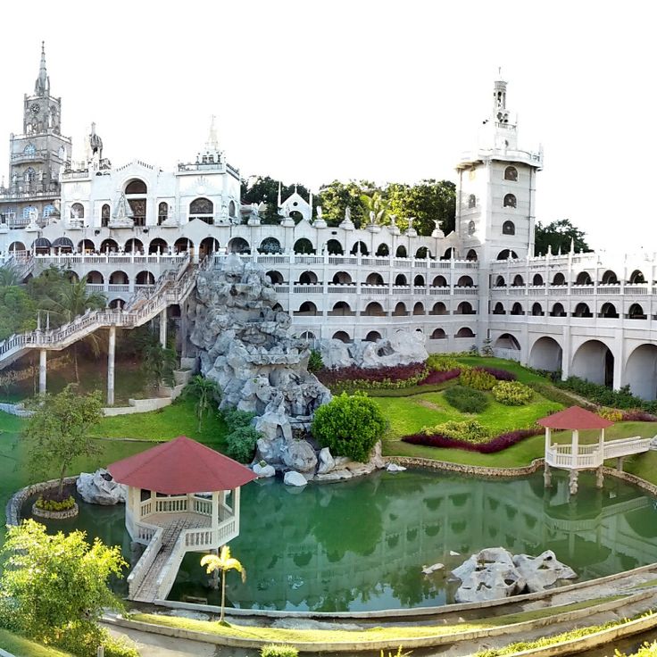
The Simala Sanctuary sits on a hill above Sibonga, built in 2002 with towers and turrets rising above the Cebu landscape. The church draws pilgrims from across the country who come to pray before the statue of the Virgen de Lindogon and light candles in the chapel. Statues of saints line the staircases, while the exterior walls display religious imagery and votive offerings. The complex offers views of the surrounding mountains and Cebu coastline from its upper levels.
This rock formation along Biri's northern coast stretches across the shoreline, where Pacific waves have shaped sandstone into jagged columns and arches over centuries. The structures reach 20 meters (66 feet) in height and display layers of sedimentary rock exposed by coastal erosion. Photographers find the best conditions during low tide, when exposed rock ledges and tidal pools become accessible.
These 2000-year-old rice terraces stretch across 10000 square miles (26000 square kilometers) of Ifugao mountains and remain in use for local rice cultivation. The terraces demonstrate traditional agricultural practices of the region and provide photo opportunities with their tiered levels extending along mountain slopes. Walking paths lead through several terrace sections.
These uniform limestone hills span 50 square kilometers (19 square miles) across Bohol and turn brown during the dry season. Around 1,770 cone-shaped mounds define the landscape and form one of the geological features of the Philippines' natural terrain. The hills reach heights between 100 and 160 feet (30 and 50 meters) and display green vegetation during the rainy season that dries out in the dry months.
Kayangan Lake sits between steep limestone cliffs on Coron Island and reaches underwater visibility of around 70 percent. The freshwater body is fed by underground springs while the surrounding rock walls rise several hundred feet. Access follows a staircase of roughly 300 steps leading from the coast to the lake basin. Photographers find clear conditions for underwater shots and views of the geological formations that define Palawan's northern landscapes.
Plage Blanche extends for 2.5 miles (4 kilometers) along the western coast of Boracay, composed of fine white coral sand and lined with coconut palms. This coastal section forms part of the Philippine island landscapes and provides access to the Sulu Sea waters, while the palm groves offer natural shade along the shoreline.
This volcano rises from an island in Taal Lake, about 31 miles (50 kilometers) south of Manila. The island volcano system spans roughly 9 miles (15 kilometers) across and shows clear evidence of eruptions from different periods. The crater lake at the summit sits about 984 feet (300 meters) above the surrounding lake. Black sand beaches along the lake shore result from past volcanic eruptions that have shaped the area over centuries.
These waterfalls in northern Laguna drop 120 feet (37 meters) into a narrow gorge, creating a natural pool at their base. Visitors reach the Pagsanjan Falls via a two-hour upstream river journey, where local boatmen navigate bamboo rafts through tight passages between rock formations and over rapids. The limestone cliffs lining the riverbanks rise on both sides, forming a forested valley that narrows toward the fall zone, where water meets the basalt layer below.
This island off the coast of Mindanao covers 437 square miles and combines surf conditions with mangrove forests and sand beaches. The Cloud 9 surf spot attracts surfers from different countries who find consistent waves of three to ten feet (one to three meters) throughout the year. The mangrove forests along the coast provide habitat for local bird species, while the beaches are lined with palm trees. Boat tours lead to surrounding islands and lagoons where visitors can swim and snorkel.
Mayon Volcano rises 8081 feet (2463 meters) above sea level and displays a nearly symmetrical cone shape. This stratovolcano remains active with regular eruptions that have shaped its appearance over centuries. The geometric profile resulted from repeated lava flows distributed evenly around the central vent, making it one of the most active volcanoes in the country.
This underground river extends five miles (eight kilometers) through limestone caves with stalactites and stalagmites beneath the surface of Palawan. The cave system shelters colonies of bats and swiftlets. Visitors explore the waterway by boat through the upper sections of the cave, where rock formations have developed over thousands of years. The cave forms part of a larger national park that connects tropical forest with coastal areas.
This triangular 16th-century fortress rises with 26-foot (8-meter) coral stone walls along the Cebu waterfront. The Spanish installation features three bastions and fourteen historic cannons positioned along the defensive perimeter. The fort served as a military base during colonial times and documents early Spanish presence in the Philippines, with preserved architecture providing insight into 16th-century fortification methods.
This 143-acre park preserves the site where José Rizal was executed in 1896 and combines gardens, monuments and museums into a space that documents Philippine history and brings together different aspects of national identity in the capital.
The Hinatuan Enchanted River emerges from an underground spring and flows directly into the Philippine Sea. Water depth reaches 260 feet (80 meters) in some sections. The clear water allows visibility to the riverbed at shallower depths. The river sits in Surigao del Sur and draws visitors who photograph the unusual waterway or swim in the upper reaches. The source itself remains largely unexplored.
This marine park in the Sulu Sea covers more than 95,000 acres (38,600 hectares) and hosts 360 coral species and 600 fish species. The reefs lie roughly 110 miles (180 kilometers) southeast of Puerto Princesa and remain accessible only during the March to June season by liveaboard diving boats. The park provides nesting grounds for several sea turtle species and attracts sharks, manta rays and dolphins. Underwater visibility often reaches 100 feet (30 meters).
These two natural saltwater lagoons near El Nido sit among limestone formations and offer clear water for snorkeling and kayaking. Big Lagoon is accessed through a narrow channel, while Small Lagoon requires passage through a rock crevice. Both lagoons display the characteristic karst landscape of Bacuit Bay, with steep cliffs and turquoise water in protected coves.
The Village du patrimoine de Vigan displays colonial Spanish architecture from the 16th century with stone houses, antique shops and traditional craft workshops. This historic town in the Philippines preserves its colonial structures along cobblestone streets where artisans still practice local techniques. The architectural consistency and ongoing craft tradition make this site a documentary subject for photographers capturing colonial heritage in Southeast Asia.
Mount Apo rises 9,692 feet (2,954 meters) above sea level, making it the highest peak in the Philippines. This volcano on Mindanao shelters various orchid species in its mountain forests, hot springs along its slopes, and serves as habitat for the Philippine eagle, one of the rarest birds of prey worldwide. The different elevation zones create multiple vegetation belts, from lowland rainforests to moss covered cloud forests near the summit. Hikers traverse sulfurous fumaroles and pass through areas of volcanic activity on their way up, reminders of the geological nature of this mountain.
This coastal zone in Palawan combines turquoise lagoons set between limestone cliffs with dive sites featuring Japanese shipwrecks from World War II. Coron Island offers photographers contrasts between sheltered bodies of water and historical underwater sites where warships rest at depths ranging from 33 to 131 feet (10 to 40 meters), now inhabited by coral formations and marine life.
The hanging coffins of Sagada demonstrate a centuries-old burial tradition of the Igorot people. Wooden coffins were attached to limestone cliffs to position the deceased closer to the gods and protect them from flooding. This burial method continues to be practiced in some areas and offers insights into the spiritual beliefs of the Cordillera region's indigenous communities.
The Tinuy-an Falls drop 180 feet (55 meters) across four natural tiers and span roughly 310 feet (95 meters) in width. Located in the tropical rainforest of Surigao del Sur province, this waterfall ranks among the widest cascades in the country. The falling water creates a fine mist at the base, while the surrounding forest maintains dense vegetation of ferns and palm trees.
This national park encompasses 124 limestone islands in the Lingayen Gulf, known for their white sand beaches and coral reefs. The islands formed through volcanic activity and subsequent erosion over several millennia. The marine protected area hosts various coral species and tropical fish populations, while the islands themselves provide nesting grounds for seabirds and are covered with mangroves and coastal vegetation.
These three-tiered waterfalls in the rainforest feed turquoise pools supplied by underground springs. The river system flows through dense tropical vegetation on Cebu, providing access to multiple swimming areas. The main cascade drops roughly 130 feet (40 meters), creating natural pools suitable for photography. Trails connect the different levels along the river course.
This underwater cemetery off the coast of Camiguin has been submerged since 1871, when a volcanic eruption sank the original burial ground. A large white cross marks the location where graves once stood. The site serves as a diving spot where visitors can swim among sunken tombstones and observe the effects of volcanic activity in the region. The site sits in shallow water near the coast of Bonbon.
These ruins of an early 20th-century Italian-style mansion stand on the grounds of a former sugar plantation in Negros Occidental. American forces burned the structure in 1942 during World War II to prevent Japanese troops from using it as headquarters. The remaining columns, arches and coral stone walls provide a glimpse into colonial-era architecture and draw photographers who capture the structures against the sky, particularly at sunset.
These rock formations rise along the northern coast of Biri Island and reach heights of up to 66 feet (20 meters). Pacific wind and waves have shaped seven distinct structures from the bedrock, spread across several coastal sections. The Magasang formation is considered the largest in the cluster, while Magsapad and Macadlaw face direct Pacific surf. Photographers use the tides for varying perspectives on the eroded surfaces and natural arches.
Bucas Grande sits in the Sigatoka archipelago and is known for its protected Sohoton Cove, where mangrove forests line karst-defined waters. The island hosts several species of non-stinging jellyfish in its brackish lagoons. Boat routes pass through narrow channels between limestone formations. Swimming areas are dictated by tidal cycles. Waters around the island provide access to additional small coves and cave entrances.
Sumaging Cave extends across 200 feet (60 meters) of vertical relief and forms the most extensive cave system in Sagada. Stalactites and stalagmites shape chambers reaching up to 60 feet (18 meters) in height, while flowstone terraces and drapery formations line the passages. The descent takes roughly two hours through narrow corridors and across smooth rock surfaces. An underground stream flows through the lower gallery, where natural pools have formed among limestone formations. Local guides accompany visitors through the technically demanding sections.
The Langun-Gobingob Caves form an extensive underground network spanning several miles and containing numerous chambers and geological formations. The system requires technical knowledge for exploring deeper sections, while surface-level areas remain accessible to less experienced visitors. These caves contain various mineral deposits and underground waterways that create opportunities for documenting subterranean environments.
The Aliwagwag Falls consist of over 80 cascades extending across a vertical distance of 1,115 feet (340 meters). This system sits in the highlands of Davao Oriental and offers trails through dense forest to various viewing points. Water flow varies between rainy and dry seasons.
This 130-foot suspension bridge connects two communities across the Sipatan River in Bohol. The structure combines bamboo planks with steel cables. Photographers document the traditional engineering and the natural river landscape of the region. The construction provides perspectives on the forested banks and flowing water below.
The island contains the two-mile (3.2-kilometer) stretch of Mahabang Buhangin Beach, where fine white sand meets clear water. Tinaga sits within the Calaguas group and draws photographers documenting coastal landscapes and the gradual shoreline during daylight hours.
The Simala Sanctuary sits on a hill above Sibonga, built in 2002 with towers and turrets rising above the Cebu landscape. The church draws pilgrims from across the country who come to pray before the statue of the Virgen de Lindogon and light candles in the chapel. Statues of saints line the staircases, while the exterior walls display religious imagery and votive offerings. The complex offers views of the surrounding mountains and Cebu coastline from its upper levels.
This rock formation along Biri's northern coast stretches across the shoreline, where Pacific waves have shaped sandstone into jagged columns and arches over centuries. The structures reach 20 meters (66 feet) in height and display layers of sedimentary rock exposed by coastal erosion. Photographers find the best conditions during low tide, when exposed rock ledges and tidal pools become accessible.