Natural sites of the Alps: lakes, gorges, and peaks to discover
The Alps offer a wide range of natural landscapes. You find mountain lakes with clear waters, like the Eibsee in Bavaria or the Sorapis Lake in the Dolomites, gorges carved by torrents like the Partnach Gorge or the Cirque of Sixt-Fer-à-Cheval, and stunning rocky peaks such as the Tre Cime di Lavaredo or Mont Aiguille in Vercors.
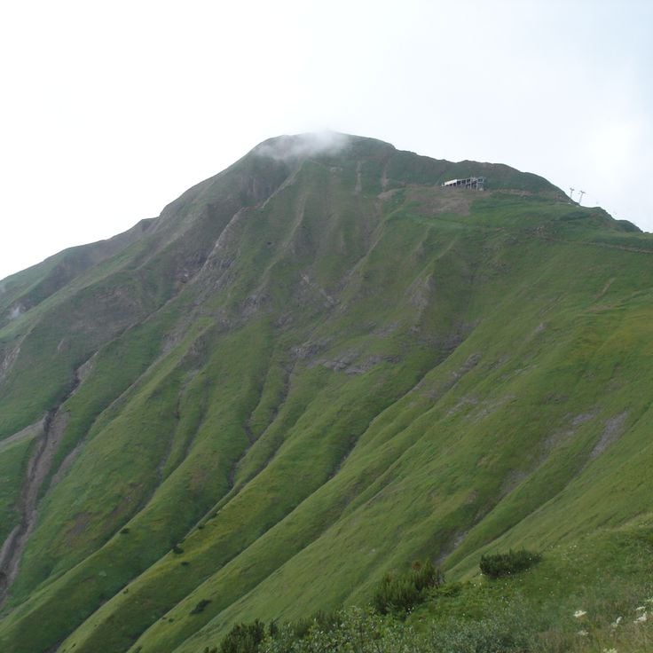
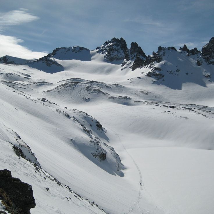
The mountain range also shows remarkable geological formations, like the Désert de Platé with its eroded limestone rocks creating endless striped surfaces, or the steep cliffs that surround the valleys and give each region its character. These sites can be reached by hiking trails, allowing visitors to see the variety of alpine scenery and how water, ice, and weather have shaped these mountains.
Natural sites of the Alps: lakes, gorges, and peaks to discover
The Alps offer a wide range of natural landscapes. You find mountain lakes with clear waters, like the Eibsee in Bavaria or the Sorapis Lake in the Dolomites, gorges carved by torrents like the Partnach Gorge or the Cirque of Sixt-Fer-à-Cheval, and stunning rocky peaks such as the Tre Cime di Lavaredo or Mont Aiguille in Vercors.
The mountain range also shows remarkable geological formations, like the Désert de Platé with its eroded limestone rocks creating endless striped surfaces, or the steep cliffs that surround the valleys and give each region its character. These sites can be reached by hiking trails, allowing visitors to see the variety of alpine scenery and how water, ice, and weather have shaped these mountains.
Lake Eibsee sits at 3192 feet (973 meters) in the Bavarian Alps, surrounded by coniferous forests. The clear water reflects the Zugspitze massif and visitors can walk the shoreline trail to discover different coves. In summer, people swim and sunbathe along the shore, while others boat across the lake or visit the small island. In winter, the lake becomes quiet and the water surface glistens in the light. The lake is accessible from Garmisch-Partenkirchen and the Zugspitze is visible from the shore. The water stays cold and fresh throughout the year.
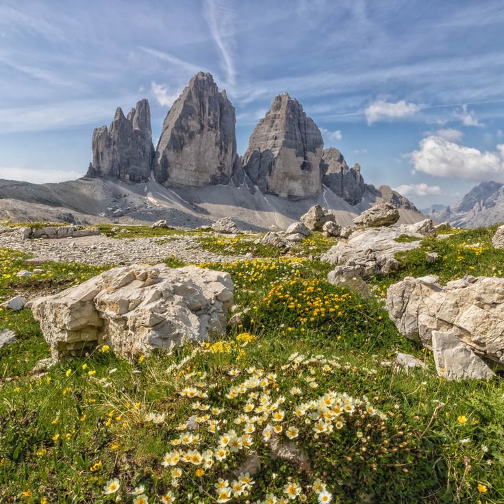
The Tre Cime di Lavaredo are among the most recognizable mountain formations in the Alps, formed by three massive rock towers made of dolomite. The tallest peak reaches a height of roughly 3000 meters (about 9800 feet). These rock faces rise almost vertically and form a natural border between two mountain valleys. Several trails circle the rock massifs and offer views of the steep northern walls. The rock comes from a time when this area was a coral reef under the sea. The three towers usually stand in contrast to the sky, and under certain light conditions the dolomite rock glows in warm tones. Many climbers attempt the steep walls, while others hike on the paths below the summits.
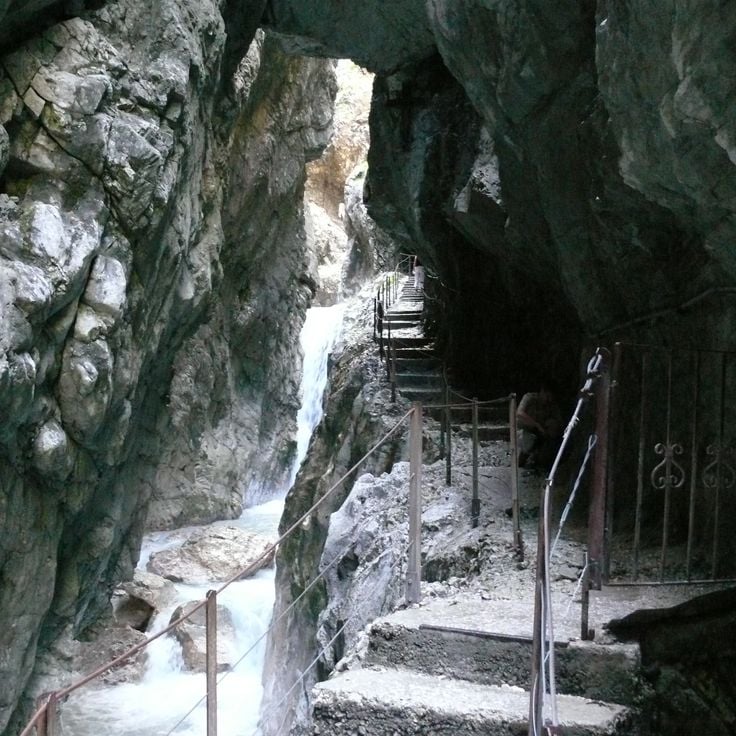
The Höllentalklamm is a narrow gorge in the Bavarian Alps that stretches about 3,300 feet (1 kilometer) between steep rock walls. The Hammersbach stream has carved a deep cut into the stone over thousands of years. Visitors enter the gorge through an entrance near Grainau and follow a secured path with railings, bridges, and short tunnel sections. Below, the mountain water rushes between smooth stones, often gray with rock flour. The rock walls rise almost vertically on both sides, sometimes close together, leaving only a narrow strip of sky visible. In some places, fine water spray drifts through the air, and the atmosphere feels cool. The Höllentalklamm is used by hikers in summer who are heading to the Höllental valley or toward Zugspitze. In winter, the gorge is closed because of ice and rockfall risk. The path through the gorge leads through changing light conditions and offers views of how water shapes rock.
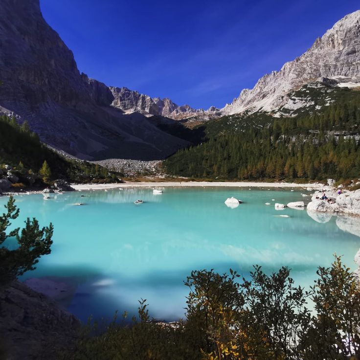
This mountain lake sits at 6,300 feet (1,925 meters) and stands out for its turquoise water, set within the mountain landscape of the Dolomites. A hiking trail leads through conifer forest and open terrain to reach it. The water gets its unusual color from minerals in the rock. From the shore, you can see the steep cliffs of the surrounding peaks.
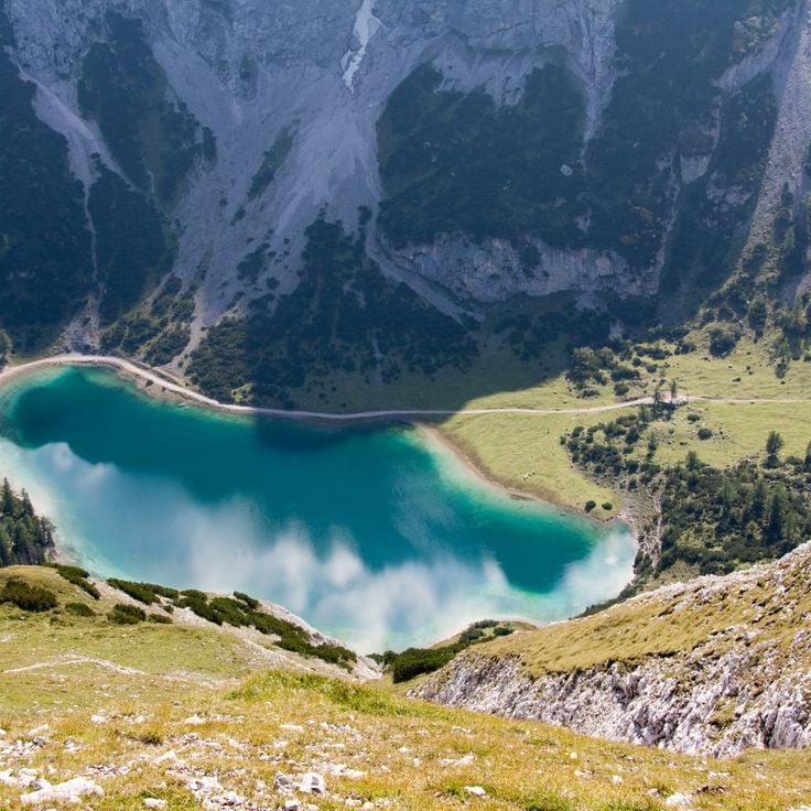
Seebensee sits at 5436 feet (1657 meters) in the Austrian Alps and reflects the rock walls of the Mieming Range. This mountain lake is surrounded by steep peaks and alpine meadows, offering clear and cold water. A trail leads from Ehrwald through forests and meadows to the shore. The reflection of the Mieming chain on the water surface shows the outlines of the surrounding peaks and rock faces, especially in the morning.
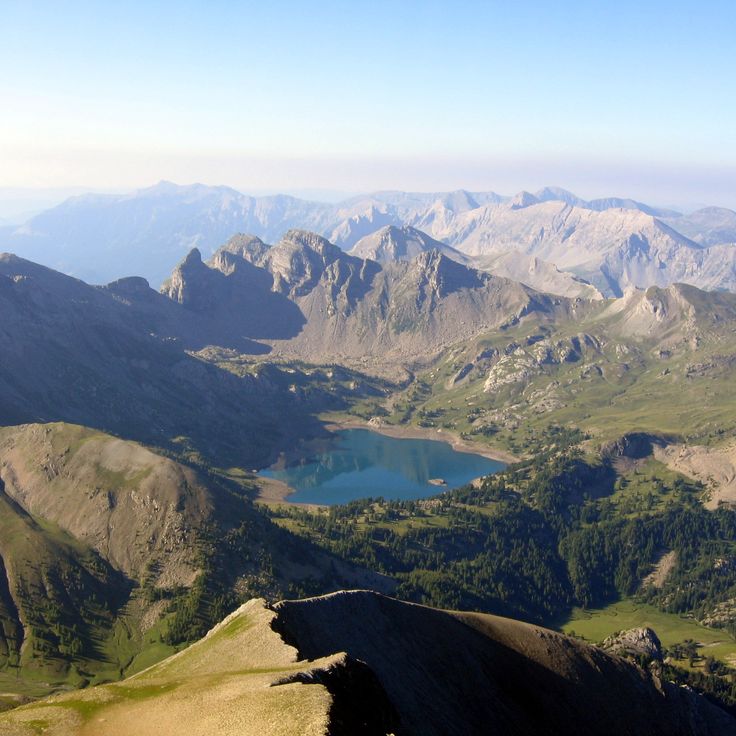
Lac d'Allos sits at 7300 feet (2227 meters) in the heart of Mercantour National Park. Covering almost 150 acres (60 hectares), it is among the largest natural lakes at this altitude in Europe. The water is cold, clear, and surrounded by rocks and grassy slopes. In summer, snow-covered peaks reflect on its surface. You reach it via a trail starting in the high valley and passing through pastures and conifer forests. The shores are often visited by hikers who rest here before heading toward higher peaks. In winter, the lake disappears under a blanket of snow.
The Cirque de Sixt-Fer-à-Cheval is a limestone formation in the Giffre valley, with walls rising between 1,600 and 2,300 feet (500 and 700 meters). Numerous waterfalls cascade down these slopes, their flow varying with the seasons. Trails through the forest lead into the area, offering a view of how erosion and glacial movement shaped alpine valleys over time. The surrounding walls close off the valley to the south and define the setting through their height and the rock, which has been altered by water over the centuries.
The Désert de Platé is a limestone plateau shaped by rainwater dissolving the rock over thousands of years. The surface is carved into parallel grooves that run across the stone, creating a striped pattern visible from a distance. The landscape feels bare and open, with little plant life between the pale gray ridges. Hikers reach this high ground through forest trails and alpine meadows. In summer, sheep sometimes graze among the formations. The wind is often strong, and on clear days the glaciers of Mont Blanc rise to the south. The area feels remote and exposed, with few signs of human presence.
Mont Aiguille rises as a single limestone peak in the Vercors to an elevation of 6850 feet (2087 meters). Its walls drop vertically on all sides for about 980 feet (300 meters). The mountain stands clearly visible at the edge of the massif and differs in shape from the surrounding peaks. Hikers reach the plateau at the top via climbing routes that lead through the steep rock faces.
The Verdon Gorge is a canyon in the southern French Alps, where the Verdon River has carved a passage through limestone over a distance of about 13 miles (21 kilometers). The rock walls rise vertically and reach heights of 820 to 2,300 feet (250 to 700 meters) above the river. The water shows various shades of green and appears turquoise in places due to minerals in the rock. Trails along the rim and staircases near the riverbed lead through this landscape, one of the deepest cuts in French mountain terrain. Narrow passages alternate with wider sections where small sandy beaches and gravel banks appear. The gorge formed through the erosive force of water, which carved out the soft limestone over thousands of years. On sunny days the water reflects light and makes the rock walls appear brighter, while in shade the colors turn darker and cooler.
The Mer de Glace is the longest glacier in France, extending 7 kilometers through the Chamonix valley. The ice flows slowly downward between steep rock walls, forming a landscape of crevasses, moraines, and polished rock. The Montenvers rack railway brings visitors to a viewing platform overlooking the glacier tongue and surrounding peaks. An ice cave is carved anew into the glacier each year, as the ice constantly moves and melts. The retreat of this glacier has been clearly visible for decades and can be traced along markers on the trail.
La Meije consists of three summits in the Écrins massif, with the Grand Pic rising to 12,972 feet (3,983 meters). This mountain group was the last major Alpine peak to be climbed, reached in 1877, and its steep walls continue to draw experienced mountaineers. The north side towers above the village of La Grave and the Romanche valley, displaying rugged ridges and ice fields. Several challenging routes approach the main summit from the south, requiring technical skill and alpine experience. The view from the top extends across the entire Dauphiné region to distant glaciers and valleys.
The Barre des Écrins rises to 13450 feet (4101 meters) and marks the highest point in the French Alps south of Mont Blanc. The summit separates the Vallouise valley to the north from the Vénéon valley to the south and remains covered by a glacier on its north face even in summer. Climbers reach the top through several routes that pass through rock walls and ice fields. On clear days, the view from the massif extends to the Italian peaks to the east and to Provence to the south.
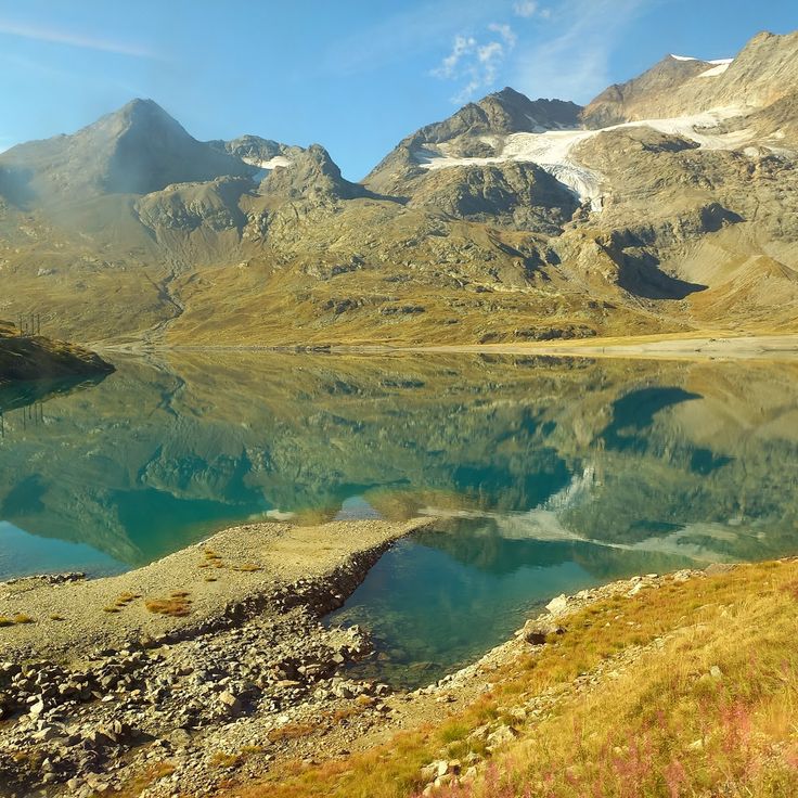
Lac des Béraudes sits in the Cerces massif at 8215 feet (2504 meters) above sea level. The water comes from the Moutet stream, which flows down between the surrounding peaks. Rock faces and scree fields shape the landscape at this elevation. The lake belongs to the high mountain lakes you reach after several hours of hiking through alpine valleys. In summer, the surface reflects the mountains around it, while in autumn the sparse vegetation near the shore changes color.
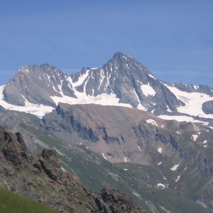
The Monte Rosa massif stretches along the border between Switzerland and Italy, forming a massive mountain range with over a dozen peaks exceeding 13,000 feet (4000 meters). The Dufourspitze rises to 15,203 feet (4634 meters) as the highest point in Switzerland. The massif carries extensive glaciers that flow down steep slopes and broad basins, casting bright light in the sun. The ridges are sharp and the flanks steep, especially on the Italian side, where rock faces drop almost vertically to the valley floor. From Zermatt, you see the glaciated north slopes, while the southern areas are accessible from the Aosta Valley. Mountaineers use various routes that cross ice and rock. The huts sit at around 10,000 feet (3000 meters) and serve as starting points. In summer, the trails draw climbers from many countries. In winter, the area remains quiet and covered in snow.
The Großglockner stands at 12,460 feet (3,798 m) and is the highest mountain in Austria. It rises in the Hohe Tauern range as a sharp rock pyramid above the surrounding peaks. Several glaciers cover its slopes, including the Pasterze, the largest glacier in the Eastern Alps. From the mountain huts in the area, various routes lead to the summit and require experience in high mountains and equipment for ice and rock. The summit of Großglockner offers a view over the valleys of Carinthia and the glaciated mountain chains extending to the south and west.
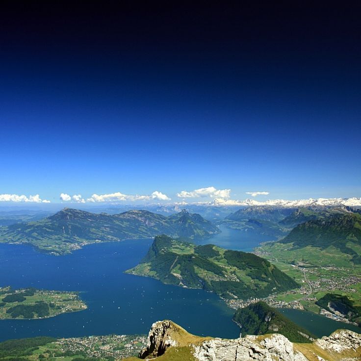
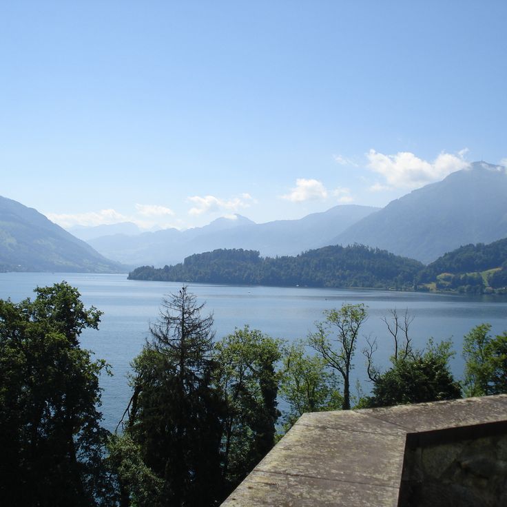
Lake Lucerne is located in central Switzerland and stretches across several cantons. Its narrow arms reach between forested slopes and steep rock faces that drop straight into the water. Small towns with churches, ferry docks, and walking paths stand along the shores. The surrounding mountains are green in summer, often snow-covered in winter. Steamboats and ferries connect the villages with each other. The water is clear and cold, deep in some places. Hiking trails lead from the shores upward, where the view opens over the entire lake. The shape of the lake is irregular, with bays and headlands formed by the surrounding terrain.
Mont Blanc rises to 15,748 feet (4807 meters) as the highest summit of the Alps and Western Europe. Its upper section is covered with glaciers that stretch between steep rocky ridges. On clear days the white dome can be seen from many valleys across the region. Several routes lead to the top, most requiring multiple days and alpine experience. The surrounding valleys offer views of the north face and the ice fields that descend from the summit.
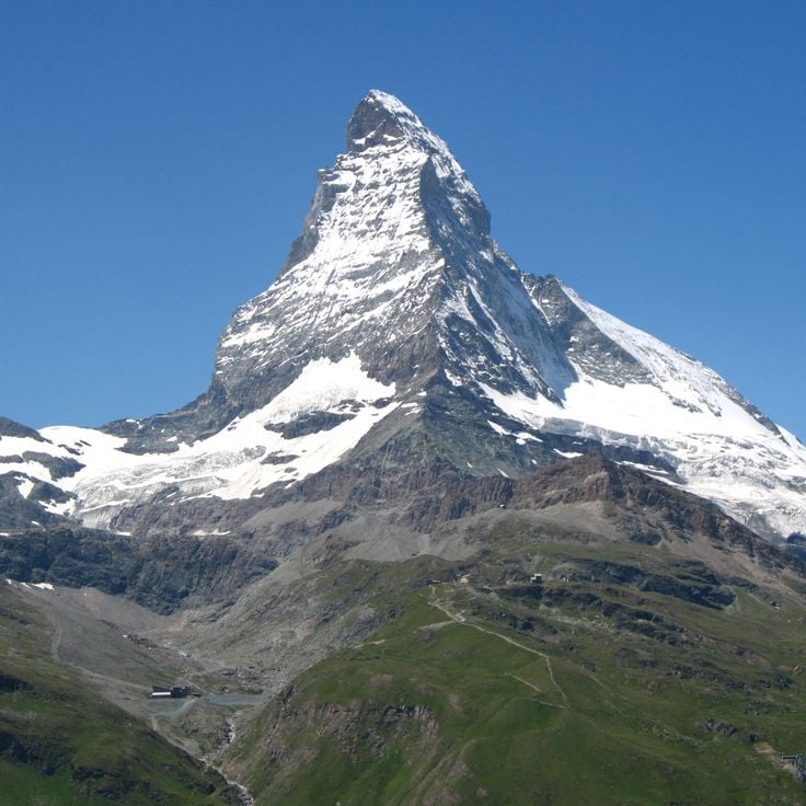
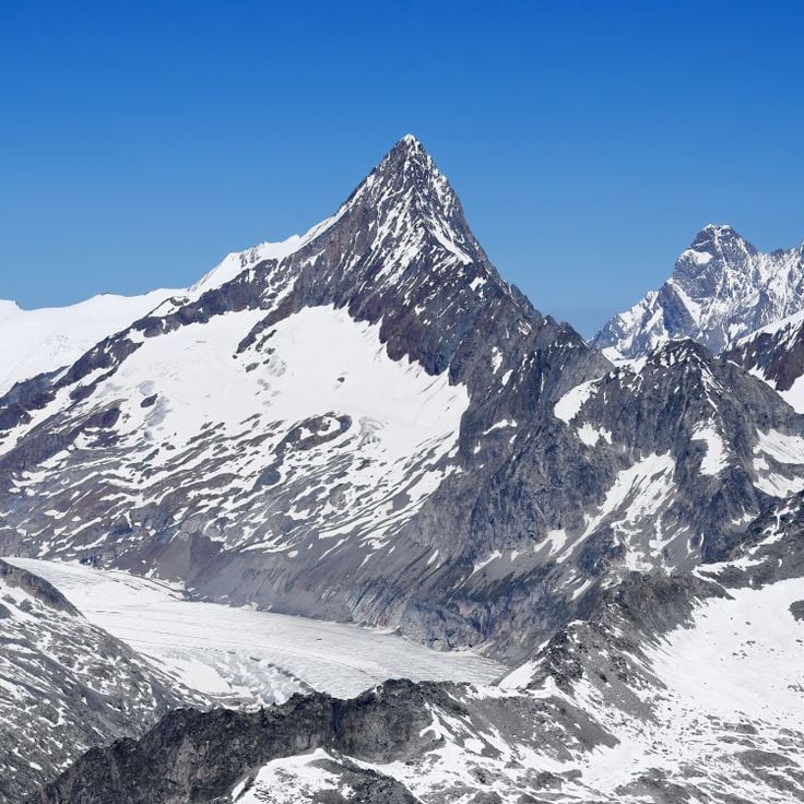
Cervino rises as a pyramid-shaped mountain in the Pennine Alps. At 14,692 feet (4,477 meters), it stands among the distinct peaks of the Alpine range. Its triangular rock faces drop steeply on both sides of the border, shaping the landscape around Zermatt and Breuil-Cervinia. The characteristic form resulted from erosion that has shaped the rock over thousands of years.
The Aletsch Glacier in Valais stretches about 14 miles (23 km) through the Bernese Alps and covers roughly 32 square miles (82 km²). The ice flows from the high peaks of the Jungfrau, Mönch, and Eiger down toward the Rhône valley. Hiking trails run along the moraines and lead to viewpoints where you can see the glacier tongue and the streams of ice. The surface shows crevasses, glacier tables, and bands of debris. In recent years the glacier has been retreating, and the changes are visible on the ground. Mountain huts and marked routes allow you to reach different sections of the glacier and watch the movement of the ice.
Lake Brienz stretches for nine miles (fourteen kilometers) between Interlaken and the small mountain village of Brienz. Its water displays a deep turquoise blue caused by fine sediment from glacial streams. Walking paths run along the shores, passing through forests and small villages, while a railway follows the northern shore between the mountains and the lake. The surrounding slopes rise steeply and merge into the peaks of the Bernese Alps, so the lake is framed by mountain ranges on all sides.
Finsteraarhorn is the highest summit in the Bernese Alps, rising to 14,022 feet (4,274 meters) between the cantons of Bern and Valais. Its name refers to the dark rock walls that define the mountain and give it a distinctive appearance. The peak sits away from major routes and is surrounded by deep glacier valleys, making it a remote destination for experienced mountaineers. The ascent requires glacier equipment and alpine experience, as the route crosses ice and steep rock flanks.
Lake Zug occupies a gentle basin in central Switzerland, surrounded by forested hills and mountains. The water is clear and shifts between green and blue depending on the light. Lakeside promenades connect several towns along the shore. From the water, you can see pre-Alpine peaks rising in the distance against the horizon. In summer, people swim and sail here. On windy days, sailboats cross the lake, while on calm evenings only small waves reach the shore.
The Bernina Glacier sits on Piz Bernina, the highest peak in the Eastern Alps at 13,284 feet (4048 meters). The glacier system spreads across the mountain's north face and feeds several smaller ice streams flowing down into the surrounding valleys. The landscape shows bare ice, crevasses, and snowfields that change with the seasons. From different viewpoints, you can watch how the ice moves slowly downhill, carrying debris and rock fragments along. The glacier is reached by mountain trails and climbing routes that pass through rocky terrain.
Pizol rises at the entrance to the Rhine Valley and reaches 9334 feet (2844 meters) in elevation. From this mountain you can see Lake Constance. Hiking trails pass through different elevations, crossing small mountain lakes and meadows that turn green in summer. In autumn the larches turn yellow. The ascent routes start from Bad Ragaz or Wangs and pass through forests before the terrain becomes more open. Once at the top, eastern Switzerland lies below the summit.
The Grand Muveran is a mountain in the western Swiss Alps where ibexes and chamois can be observed in their natural habitat. The slopes of this peak stretch over steep rock faces and alpine meadows that wildlife visits during summer. Hiking trails lead through this landscape and offer opportunities to encounter alpine fauna. The elevation and remoteness create favorable conditions for these animals, which have adapted to the harsh mountain climate.
The Silberen forms the largest karst plateau in Switzerland and shows the result of thousands of years of erosion. The limestone here is cut by deep grooves that rainwater has carved into the surface over time. The ground is gray and cracked in many places, broken by isolated depressions and small caves where water disappears underground. Those who hike up to the plateau move through a barren landscape where only scattered grasses and low plants grow. The air is often cool and the wind sweeps across the open expanse. The view extends far over the rugged terrain to the surrounding peaks.
The Grand Combin is a mountain group in the Alps that reaches 4,135 meters (13,566 feet). Its upper slopes are covered with glaciers that stretch between the rocky peaks. The massif sits south of the main chain and forms a distinct group visible from the valleys below. The slopes are steep, the ice fields wide, and the shape of the mountain changes depending on where you stand. Trails lead up to the higher areas where you can see the glaciers up close and look out over the surrounding valleys.
Brienzer Rothorn rises to 7700 feet (2350 meters) in the Emmental Alps. From its viewpoints, you look out over Lake Brienz and the surrounding mountain ranges. The summit area can be reached by hiking trails and a historic cogwheel railway that has been running since the late 19th century. Standing here, you see how the Alpine chains layer one behind another and how the lakeshore lies far below in the valley. Vegetation becomes sparse on the way to the top, with rocks and alpine meadows shaping the scene. On clear days, the view extends toward the Jura and the Swiss Plateau. In summer, cows graze on the mountain pastures below the summit. Brienzer Rothorn is one of those places in the Alps where you get a broad sense of the mountain landscape.
Lake Eibsee sits at 3192 feet (973 meters) in the Bavarian Alps, surrounded by coniferous forests. The clear water reflects the Zugspitze massif and visitors can walk the shoreline trail to discover different coves. In summer, people swim and sunbathe along the shore, while others boat across the lake or visit the small island. In winter, the lake becomes quiet and the water surface glistens in the light. The lake is accessible from Garmisch-Partenkirchen and the Zugspitze is visible from the shore. The water stays cold and fresh throughout the year.
The Tre Cime di Lavaredo are among the most recognizable mountain formations in the Alps, formed by three massive rock towers made of dolomite. The tallest peak reaches a height of roughly 3000 meters (about 9800 feet). These rock faces rise almost vertically and form a natural border between two mountain valleys. Several trails circle the rock massifs and offer views of the steep northern walls. The rock comes from a time when this area was a coral reef under the sea. The three towers usually stand in contrast to the sky, and under certain light conditions the dolomite rock glows in warm tones. Many climbers attempt the steep walls, while others hike on the paths below the summits.
The Höllentalklamm is a narrow gorge in the Bavarian Alps that stretches about 3,300 feet (1 kilometer) between steep rock walls. The Hammersbach stream has carved a deep cut into the stone over thousands of years. Visitors enter the gorge through an entrance near Grainau and follow a secured path with railings, bridges, and short tunnel sections. Below, the mountain water rushes between smooth stones, often gray with rock flour. The rock walls rise almost vertically on both sides, sometimes close together, leaving only a narrow strip of sky visible. In some places, fine water spray drifts through the air, and the atmosphere feels cool. The Höllentalklamm is used by hikers in summer who are heading to the Höllental valley or toward Zugspitze. In winter, the gorge is closed because of ice and rockfall risk. The path through the gorge leads through changing light conditions and offers views of how water shapes rock.
This mountain lake sits at 6,300 feet (1,925 meters) and stands out for its turquoise water, set within the mountain landscape of the Dolomites. A hiking trail leads through conifer forest and open terrain to reach it. The water gets its unusual color from minerals in the rock. From the shore, you can see the steep cliffs of the surrounding peaks.
Seebensee sits at 5436 feet (1657 meters) in the Austrian Alps and reflects the rock walls of the Mieming Range. This mountain lake is surrounded by steep peaks and alpine meadows, offering clear and cold water. A trail leads from Ehrwald through forests and meadows to the shore. The reflection of the Mieming chain on the water surface shows the outlines of the surrounding peaks and rock faces, especially in the morning.
Lac d'Allos sits at 7300 feet (2227 meters) in the heart of Mercantour National Park. Covering almost 150 acres (60 hectares), it is among the largest natural lakes at this altitude in Europe. The water is cold, clear, and surrounded by rocks and grassy slopes. In summer, snow-covered peaks reflect on its surface. You reach it via a trail starting in the high valley and passing through pastures and conifer forests. The shores are often visited by hikers who rest here before heading toward higher peaks. In winter, the lake disappears under a blanket of snow.
The Cirque de Sixt-Fer-à-Cheval is a limestone formation in the Giffre valley, with walls rising between 1,600 and 2,300 feet (500 and 700 meters). Numerous waterfalls cascade down these slopes, their flow varying with the seasons. Trails through the forest lead into the area, offering a view of how erosion and glacial movement shaped alpine valleys over time. The surrounding walls close off the valley to the south and define the setting through their height and the rock, which has been altered by water over the centuries.
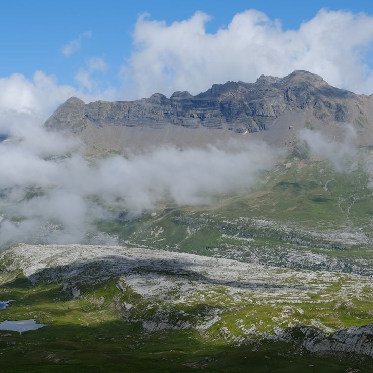
The Désert de Platé is a limestone plateau shaped by rainwater dissolving the rock over thousands of years. The surface is carved into parallel grooves that run across the stone, creating a striped pattern visible from a distance. The landscape feels bare and open, with little plant life between the pale gray ridges. Hikers reach this high ground through forest trails and alpine meadows. In summer, sheep sometimes graze among the formations. The wind is often strong, and on clear days the glaciers of Mont Blanc rise to the south. The area feels remote and exposed, with few signs of human presence.
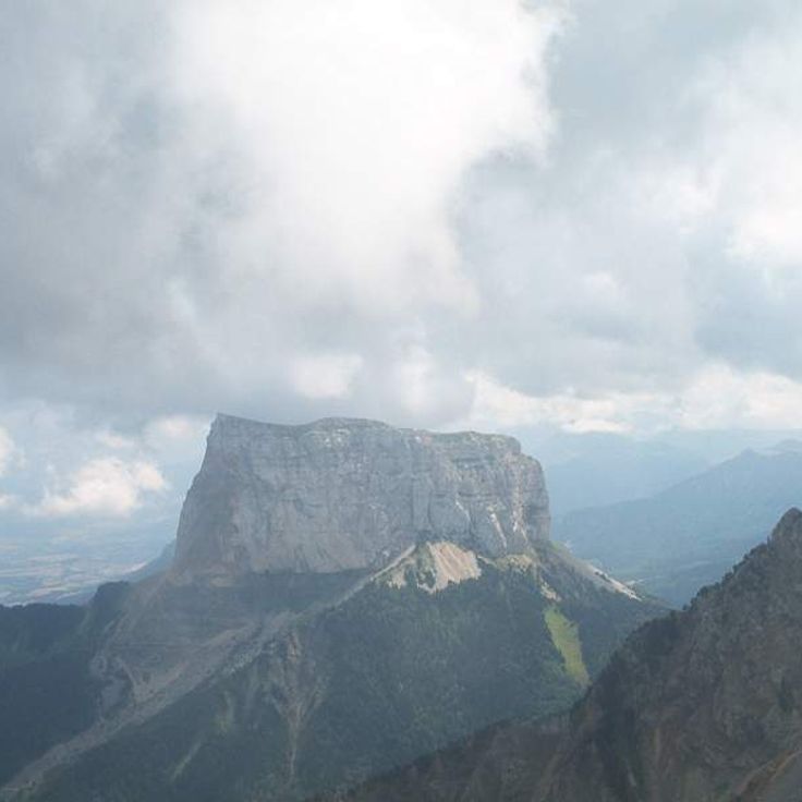
Mont Aiguille rises as a single limestone peak in the Vercors to an elevation of 6850 feet (2087 meters). Its walls drop vertically on all sides for about 980 feet (300 meters). The mountain stands clearly visible at the edge of the massif and differs in shape from the surrounding peaks. Hikers reach the plateau at the top via climbing routes that lead through the steep rock faces.
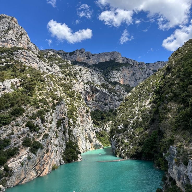
The Verdon Gorge is a canyon in the southern French Alps, where the Verdon River has carved a passage through limestone over a distance of about 13 miles (21 kilometers). The rock walls rise vertically and reach heights of 820 to 2,300 feet (250 to 700 meters) above the river. The water shows various shades of green and appears turquoise in places due to minerals in the rock. Trails along the rim and staircases near the riverbed lead through this landscape, one of the deepest cuts in French mountain terrain. Narrow passages alternate with wider sections where small sandy beaches and gravel banks appear. The gorge formed through the erosive force of water, which carved out the soft limestone over thousands of years. On sunny days the water reflects light and makes the rock walls appear brighter, while in shade the colors turn darker and cooler.
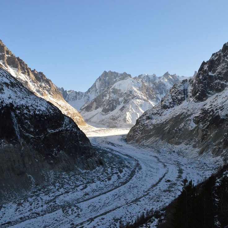
The Mer de Glace is the longest glacier in France, extending 7 kilometers through the Chamonix valley. The ice flows slowly downward between steep rock walls, forming a landscape of crevasses, moraines, and polished rock. The Montenvers rack railway brings visitors to a viewing platform overlooking the glacier tongue and surrounding peaks. An ice cave is carved anew into the glacier each year, as the ice constantly moves and melts. The retreat of this glacier has been clearly visible for decades and can be traced along markers on the trail.
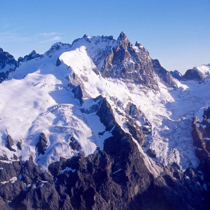
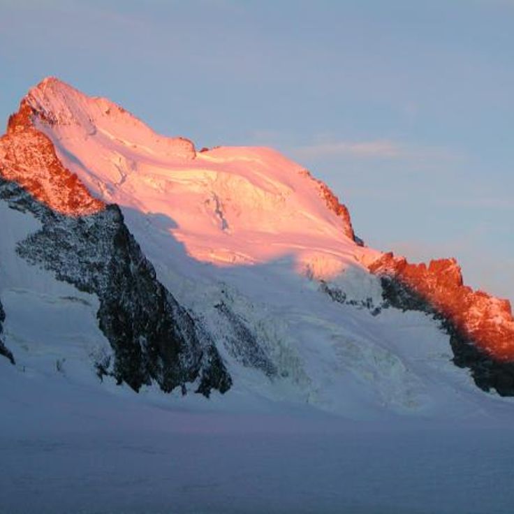
La Meije consists of three summits in the Écrins massif, with the Grand Pic rising to 12,972 feet (3,983 meters). This mountain group was the last major Alpine peak to be climbed, reached in 1877, and its steep walls continue to draw experienced mountaineers. The north side towers above the village of La Grave and the Romanche valley, displaying rugged ridges and ice fields. Several challenging routes approach the main summit from the south, requiring technical skill and alpine experience. The view from the top extends across the entire Dauphiné region to distant glaciers and valleys.
The Barre des Écrins rises to 13450 feet (4101 meters) and marks the highest point in the French Alps south of Mont Blanc. The summit separates the Vallouise valley to the north from the Vénéon valley to the south and remains covered by a glacier on its north face even in summer. Climbers reach the top through several routes that pass through rock walls and ice fields. On clear days, the view from the massif extends to the Italian peaks to the east and to Provence to the south.
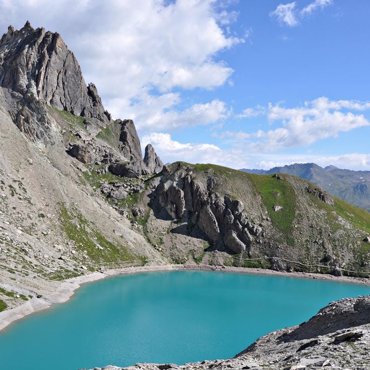
Lac des Béraudes sits in the Cerces massif at 8215 feet (2504 meters) above sea level. The water comes from the Moutet stream, which flows down between the surrounding peaks. Rock faces and scree fields shape the landscape at this elevation. The lake belongs to the high mountain lakes you reach after several hours of hiking through alpine valleys. In summer, the surface reflects the mountains around it, while in autumn the sparse vegetation near the shore changes color.
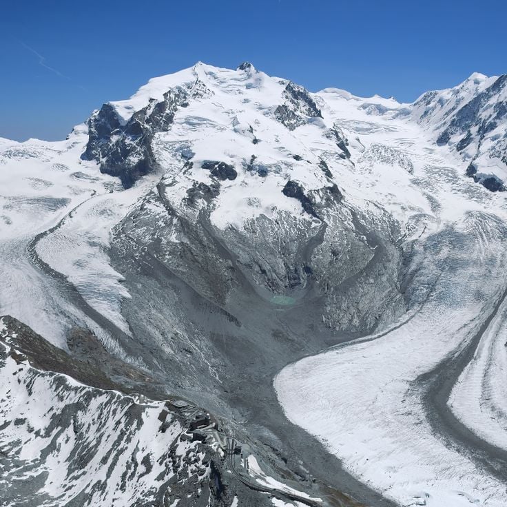
The Monte Rosa massif stretches along the border between Switzerland and Italy, forming a massive mountain range with over a dozen peaks exceeding 13,000 feet (4000 meters). The Dufourspitze rises to 15,203 feet (4634 meters) as the highest point in Switzerland. The massif carries extensive glaciers that flow down steep slopes and broad basins, casting bright light in the sun. The ridges are sharp and the flanks steep, especially on the Italian side, where rock faces drop almost vertically to the valley floor. From Zermatt, you see the glaciated north slopes, while the southern areas are accessible from the Aosta Valley. Mountaineers use various routes that cross ice and rock. The huts sit at around 10,000 feet (3000 meters) and serve as starting points. In summer, the trails draw climbers from many countries. In winter, the area remains quiet and covered in snow.
The Großglockner stands at 12,460 feet (3,798 m) and is the highest mountain in Austria. It rises in the Hohe Tauern range as a sharp rock pyramid above the surrounding peaks. Several glaciers cover its slopes, including the Pasterze, the largest glacier in the Eastern Alps. From the mountain huts in the area, various routes lead to the summit and require experience in high mountains and equipment for ice and rock. The summit of Großglockner offers a view over the valleys of Carinthia and the glaciated mountain chains extending to the south and west.
Lake Lucerne is located in central Switzerland and stretches across several cantons. Its narrow arms reach between forested slopes and steep rock faces that drop straight into the water. Small towns with churches, ferry docks, and walking paths stand along the shores. The surrounding mountains are green in summer, often snow-covered in winter. Steamboats and ferries connect the villages with each other. The water is clear and cold, deep in some places. Hiking trails lead from the shores upward, where the view opens over the entire lake. The shape of the lake is irregular, with bays and headlands formed by the surrounding terrain.
Mont Blanc rises to 15,748 feet (4807 meters) as the highest summit of the Alps and Western Europe. Its upper section is covered with glaciers that stretch between steep rocky ridges. On clear days the white dome can be seen from many valleys across the region. Several routes lead to the top, most requiring multiple days and alpine experience. The surrounding valleys offer views of the north face and the ice fields that descend from the summit.
Cervino rises as a pyramid-shaped mountain in the Pennine Alps. At 14,692 feet (4,477 meters), it stands among the distinct peaks of the Alpine range. Its triangular rock faces drop steeply on both sides of the border, shaping the landscape around Zermatt and Breuil-Cervinia. The characteristic form resulted from erosion that has shaped the rock over thousands of years.
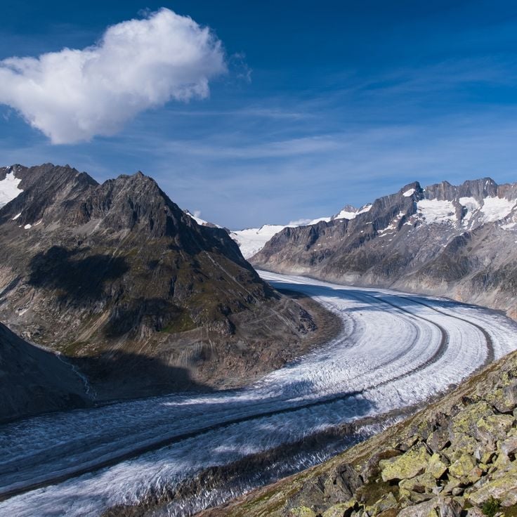
The Aletsch Glacier in Valais stretches about 14 miles (23 km) through the Bernese Alps and covers roughly 32 square miles (82 km²). The ice flows from the high peaks of the Jungfrau, Mönch, and Eiger down toward the Rhône valley. Hiking trails run along the moraines and lead to viewpoints where you can see the glacier tongue and the streams of ice. The surface shows crevasses, glacier tables, and bands of debris. In recent years the glacier has been retreating, and the changes are visible on the ground. Mountain huts and marked routes allow you to reach different sections of the glacier and watch the movement of the ice.
Lake Brienz stretches for nine miles (fourteen kilometers) between Interlaken and the small mountain village of Brienz. Its water displays a deep turquoise blue caused by fine sediment from glacial streams. Walking paths run along the shores, passing through forests and small villages, while a railway follows the northern shore between the mountains and the lake. The surrounding slopes rise steeply and merge into the peaks of the Bernese Alps, so the lake is framed by mountain ranges on all sides.
Finsteraarhorn is the highest summit in the Bernese Alps, rising to 14,022 feet (4,274 meters) between the cantons of Bern and Valais. Its name refers to the dark rock walls that define the mountain and give it a distinctive appearance. The peak sits away from major routes and is surrounded by deep glacier valleys, making it a remote destination for experienced mountaineers. The ascent requires glacier equipment and alpine experience, as the route crosses ice and steep rock flanks.
Lake Zug occupies a gentle basin in central Switzerland, surrounded by forested hills and mountains. The water is clear and shifts between green and blue depending on the light. Lakeside promenades connect several towns along the shore. From the water, you can see pre-Alpine peaks rising in the distance against the horizon. In summer, people swim and sail here. On windy days, sailboats cross the lake, while on calm evenings only small waves reach the shore.
The Bernina Glacier sits on Piz Bernina, the highest peak in the Eastern Alps at 13,284 feet (4048 meters). The glacier system spreads across the mountain's north face and feeds several smaller ice streams flowing down into the surrounding valleys. The landscape shows bare ice, crevasses, and snowfields that change with the seasons. From different viewpoints, you can watch how the ice moves slowly downhill, carrying debris and rock fragments along. The glacier is reached by mountain trails and climbing routes that pass through rocky terrain.
Pizol rises at the entrance to the Rhine Valley and reaches 9334 feet (2844 meters) in elevation. From this mountain you can see Lake Constance. Hiking trails pass through different elevations, crossing small mountain lakes and meadows that turn green in summer. In autumn the larches turn yellow. The ascent routes start from Bad Ragaz or Wangs and pass through forests before the terrain becomes more open. Once at the top, eastern Switzerland lies below the summit.
The Grand Muveran is a mountain in the western Swiss Alps where ibexes and chamois can be observed in their natural habitat. The slopes of this peak stretch over steep rock faces and alpine meadows that wildlife visits during summer. Hiking trails lead through this landscape and offer opportunities to encounter alpine fauna. The elevation and remoteness create favorable conditions for these animals, which have adapted to the harsh mountain climate.
The Silberen forms the largest karst plateau in Switzerland and shows the result of thousands of years of erosion. The limestone here is cut by deep grooves that rainwater has carved into the surface over time. The ground is gray and cracked in many places, broken by isolated depressions and small caves where water disappears underground. Those who hike up to the plateau move through a barren landscape where only scattered grasses and low plants grow. The air is often cool and the wind sweeps across the open expanse. The view extends far over the rugged terrain to the surrounding peaks.
The Grand Combin is a mountain group in the Alps that reaches 4,135 meters (13,566 feet). Its upper slopes are covered with glaciers that stretch between the rocky peaks. The massif sits south of the main chain and forms a distinct group visible from the valleys below. The slopes are steep, the ice fields wide, and the shape of the mountain changes depending on where you stand. Trails lead up to the higher areas where you can see the glaciers up close and look out over the surrounding valleys.
Brienzer Rothorn rises to 7700 feet (2350 meters) in the Emmental Alps. From its viewpoints, you look out over Lake Brienz and the surrounding mountain ranges. The summit area can be reached by hiking trails and a historic cogwheel railway that has been running since the late 19th century. Standing here, you see how the Alpine chains layer one behind another and how the lakeshore lies far below in the valley. Vegetation becomes sparse on the way to the top, with rocks and alpine meadows shaping the scene. On clear days, the view extends toward the Jura and the Swiss Plateau. In summer, cows graze on the mountain pastures below the summit. Brienzer Rothorn is one of those places in the Alps where you get a broad sense of the mountain landscape.
Lake Eibsee sits at 3192 feet (973 meters) in the Bavarian Alps, surrounded by coniferous forests. The clear water reflects the Zugspitze massif and visitors can walk the shoreline trail to discover different coves. In summer, people swim and sunbathe along the shore, while others boat across the lake or visit the small island. In winter, the lake becomes quiet and the water surface glistens in the light. The lake is accessible from Garmisch-Partenkirchen and the Zugspitze is visible from the shore. The water stays cold and fresh throughout the year.
The Tre Cime di Lavaredo are among the most recognizable mountain formations in the Alps, formed by three massive rock towers made of dolomite. The tallest peak reaches a height of roughly 3000 meters (about 9800 feet). These rock faces rise almost vertically and form a natural border between two mountain valleys. Several trails circle the rock massifs and offer views of the steep northern walls. The rock comes from a time when this area was a coral reef under the sea. The three towers usually stand in contrast to the sky, and under certain light conditions the dolomite rock glows in warm tones. Many climbers attempt the steep walls, while others hike on the paths below the summits.
The Höllentalklamm is a narrow gorge in the Bavarian Alps that stretches about 3,300 feet (1 kilometer) between steep rock walls. The Hammersbach stream has carved a deep cut into the stone over thousands of years. Visitors enter the gorge through an entrance near Grainau and follow a secured path with railings, bridges, and short tunnel sections. Below, the mountain water rushes between smooth stones, often gray with rock flour. The rock walls rise almost vertically on both sides, sometimes close together, leaving only a narrow strip of sky visible. In some places, fine water spray drifts through the air, and the atmosphere feels cool. The Höllentalklamm is used by hikers in summer who are heading to the Höllental valley or toward Zugspitze. In winter, the gorge is closed because of ice and rockfall risk. The path through the gorge leads through changing light conditions and offers views of how water shapes rock.
This mountain lake sits at 6,300 feet (1,925 meters) and stands out for its turquoise water, set within the mountain landscape of the Dolomites. A hiking trail leads through conifer forest and open terrain to reach it. The water gets its unusual color from minerals in the rock. From the shore, you can see the steep cliffs of the surrounding peaks.
Seebensee sits at 5436 feet (1657 meters) in the Austrian Alps and reflects the rock walls of the Mieming Range. This mountain lake is surrounded by steep peaks and alpine meadows, offering clear and cold water. A trail leads from Ehrwald through forests and meadows to the shore. The reflection of the Mieming chain on the water surface shows the outlines of the surrounding peaks and rock faces, especially in the morning.
Lac d'Allos sits at 7300 feet (2227 meters) in the heart of Mercantour National Park. Covering almost 150 acres (60 hectares), it is among the largest natural lakes at this altitude in Europe. The water is cold, clear, and surrounded by rocks and grassy slopes. In summer, snow-covered peaks reflect on its surface. You reach it via a trail starting in the high valley and passing through pastures and conifer forests. The shores are often visited by hikers who rest here before heading toward higher peaks. In winter, the lake disappears under a blanket of snow.
The Cirque de Sixt-Fer-à-Cheval is a limestone formation in the Giffre valley, with walls rising between 1,600 and 2,300 feet (500 and 700 meters). Numerous waterfalls cascade down these slopes, their flow varying with the seasons. Trails through the forest lead into the area, offering a view of how erosion and glacial movement shaped alpine valleys over time. The surrounding walls close off the valley to the south and define the setting through their height and the rock, which has been altered by water over the centuries.
The Désert de Platé is a limestone plateau shaped by rainwater dissolving the rock over thousands of years. The surface is carved into parallel grooves that run across the stone, creating a striped pattern visible from a distance. The landscape feels bare and open, with little plant life between the pale gray ridges. Hikers reach this high ground through forest trails and alpine meadows. In summer, sheep sometimes graze among the formations. The wind is often strong, and on clear days the glaciers of Mont Blanc rise to the south. The area feels remote and exposed, with few signs of human presence.
Mont Aiguille rises as a single limestone peak in the Vercors to an elevation of 6850 feet (2087 meters). Its walls drop vertically on all sides for about 980 feet (300 meters). The mountain stands clearly visible at the edge of the massif and differs in shape from the surrounding peaks. Hikers reach the plateau at the top via climbing routes that lead through the steep rock faces.
The Verdon Gorge is a canyon in the southern French Alps, where the Verdon River has carved a passage through limestone over a distance of about 13 miles (21 kilometers). The rock walls rise vertically and reach heights of 820 to 2,300 feet (250 to 700 meters) above the river. The water shows various shades of green and appears turquoise in places due to minerals in the rock. Trails along the rim and staircases near the riverbed lead through this landscape, one of the deepest cuts in French mountain terrain. Narrow passages alternate with wider sections where small sandy beaches and gravel banks appear. The gorge formed through the erosive force of water, which carved out the soft limestone over thousands of years. On sunny days the water reflects light and makes the rock walls appear brighter, while in shade the colors turn darker and cooler.
The Mer de Glace is the longest glacier in France, extending 7 kilometers through the Chamonix valley. The ice flows slowly downward between steep rock walls, forming a landscape of crevasses, moraines, and polished rock. The Montenvers rack railway brings visitors to a viewing platform overlooking the glacier tongue and surrounding peaks. An ice cave is carved anew into the glacier each year, as the ice constantly moves and melts. The retreat of this glacier has been clearly visible for decades and can be traced along markers on the trail.
La Meije consists of three summits in the Écrins massif, with the Grand Pic rising to 12,972 feet (3,983 meters). This mountain group was the last major Alpine peak to be climbed, reached in 1877, and its steep walls continue to draw experienced mountaineers. The north side towers above the village of La Grave and the Romanche valley, displaying rugged ridges and ice fields. Several challenging routes approach the main summit from the south, requiring technical skill and alpine experience. The view from the top extends across the entire Dauphiné region to distant glaciers and valleys.
The Barre des Écrins rises to 13450 feet (4101 meters) and marks the highest point in the French Alps south of Mont Blanc. The summit separates the Vallouise valley to the north from the Vénéon valley to the south and remains covered by a glacier on its north face even in summer. Climbers reach the top through several routes that pass through rock walls and ice fields. On clear days, the view from the massif extends to the Italian peaks to the east and to Provence to the south.
Lac des Béraudes sits in the Cerces massif at 8215 feet (2504 meters) above sea level. The water comes from the Moutet stream, which flows down between the surrounding peaks. Rock faces and scree fields shape the landscape at this elevation. The lake belongs to the high mountain lakes you reach after several hours of hiking through alpine valleys. In summer, the surface reflects the mountains around it, while in autumn the sparse vegetation near the shore changes color.
The Monte Rosa massif stretches along the border between Switzerland and Italy, forming a massive mountain range with over a dozen peaks exceeding 13,000 feet (4000 meters). The Dufourspitze rises to 15,203 feet (4634 meters) as the highest point in Switzerland. The massif carries extensive glaciers that flow down steep slopes and broad basins, casting bright light in the sun. The ridges are sharp and the flanks steep, especially on the Italian side, where rock faces drop almost vertically to the valley floor. From Zermatt, you see the glaciated north slopes, while the southern areas are accessible from the Aosta Valley. Mountaineers use various routes that cross ice and rock. The huts sit at around 10,000 feet (3000 meters) and serve as starting points. In summer, the trails draw climbers from many countries. In winter, the area remains quiet and covered in snow.
The Großglockner stands at 12,460 feet (3,798 m) and is the highest mountain in Austria. It rises in the Hohe Tauern range as a sharp rock pyramid above the surrounding peaks. Several glaciers cover its slopes, including the Pasterze, the largest glacier in the Eastern Alps. From the mountain huts in the area, various routes lead to the summit and require experience in high mountains and equipment for ice and rock. The summit of Großglockner offers a view over the valleys of Carinthia and the glaciated mountain chains extending to the south and west.
Lake Lucerne is located in central Switzerland and stretches across several cantons. Its narrow arms reach between forested slopes and steep rock faces that drop straight into the water. Small towns with churches, ferry docks, and walking paths stand along the shores. The surrounding mountains are green in summer, often snow-covered in winter. Steamboats and ferries connect the villages with each other. The water is clear and cold, deep in some places. Hiking trails lead from the shores upward, where the view opens over the entire lake. The shape of the lake is irregular, with bays and headlands formed by the surrounding terrain.
Mont Blanc rises to 15,748 feet (4807 meters) as the highest summit of the Alps and Western Europe. Its upper section is covered with glaciers that stretch between steep rocky ridges. On clear days the white dome can be seen from many valleys across the region. Several routes lead to the top, most requiring multiple days and alpine experience. The surrounding valleys offer views of the north face and the ice fields that descend from the summit.
Cervino rises as a pyramid-shaped mountain in the Pennine Alps. At 14,692 feet (4,477 meters), it stands among the distinct peaks of the Alpine range. Its triangular rock faces drop steeply on both sides of the border, shaping the landscape around Zermatt and Breuil-Cervinia. The characteristic form resulted from erosion that has shaped the rock over thousands of years.
The Aletsch Glacier in Valais stretches about 14 miles (23 km) through the Bernese Alps and covers roughly 32 square miles (82 km²). The ice flows from the high peaks of the Jungfrau, Mönch, and Eiger down toward the Rhône valley. Hiking trails run along the moraines and lead to viewpoints where you can see the glacier tongue and the streams of ice. The surface shows crevasses, glacier tables, and bands of debris. In recent years the glacier has been retreating, and the changes are visible on the ground. Mountain huts and marked routes allow you to reach different sections of the glacier and watch the movement of the ice.
Lake Brienz stretches for nine miles (fourteen kilometers) between Interlaken and the small mountain village of Brienz. Its water displays a deep turquoise blue caused by fine sediment from glacial streams. Walking paths run along the shores, passing through forests and small villages, while a railway follows the northern shore between the mountains and the lake. The surrounding slopes rise steeply and merge into the peaks of the Bernese Alps, so the lake is framed by mountain ranges on all sides.
Finsteraarhorn is the highest summit in the Bernese Alps, rising to 14,022 feet (4,274 meters) between the cantons of Bern and Valais. Its name refers to the dark rock walls that define the mountain and give it a distinctive appearance. The peak sits away from major routes and is surrounded by deep glacier valleys, making it a remote destination for experienced mountaineers. The ascent requires glacier equipment and alpine experience, as the route crosses ice and steep rock flanks.
Lake Zug occupies a gentle basin in central Switzerland, surrounded by forested hills and mountains. The water is clear and shifts between green and blue depending on the light. Lakeside promenades connect several towns along the shore. From the water, you can see pre-Alpine peaks rising in the distance against the horizon. In summer, people swim and sail here. On windy days, sailboats cross the lake, while on calm evenings only small waves reach the shore.
The Bernina Glacier sits on Piz Bernina, the highest peak in the Eastern Alps at 13,284 feet (4048 meters). The glacier system spreads across the mountain's north face and feeds several smaller ice streams flowing down into the surrounding valleys. The landscape shows bare ice, crevasses, and snowfields that change with the seasons. From different viewpoints, you can watch how the ice moves slowly downhill, carrying debris and rock fragments along. The glacier is reached by mountain trails and climbing routes that pass through rocky terrain.
Pizol rises at the entrance to the Rhine Valley and reaches 9334 feet (2844 meters) in elevation. From this mountain you can see Lake Constance. Hiking trails pass through different elevations, crossing small mountain lakes and meadows that turn green in summer. In autumn the larches turn yellow. The ascent routes start from Bad Ragaz or Wangs and pass through forests before the terrain becomes more open. Once at the top, eastern Switzerland lies below the summit.
The Grand Muveran is a mountain in the western Swiss Alps where ibexes and chamois can be observed in their natural habitat. The slopes of this peak stretch over steep rock faces and alpine meadows that wildlife visits during summer. Hiking trails lead through this landscape and offer opportunities to encounter alpine fauna. The elevation and remoteness create favorable conditions for these animals, which have adapted to the harsh mountain climate.
The Silberen forms the largest karst plateau in Switzerland and shows the result of thousands of years of erosion. The limestone here is cut by deep grooves that rainwater has carved into the surface over time. The ground is gray and cracked in many places, broken by isolated depressions and small caves where water disappears underground. Those who hike up to the plateau move through a barren landscape where only scattered grasses and low plants grow. The air is often cool and the wind sweeps across the open expanse. The view extends far over the rugged terrain to the surrounding peaks.
The Grand Combin is a mountain group in the Alps that reaches 4,135 meters (13,566 feet). Its upper slopes are covered with glaciers that stretch between the rocky peaks. The massif sits south of the main chain and forms a distinct group visible from the valleys below. The slopes are steep, the ice fields wide, and the shape of the mountain changes depending on where you stand. Trails lead up to the higher areas where you can see the glaciers up close and look out over the surrounding valleys.
Brienzer Rothorn rises to 7700 feet (2350 meters) in the Emmental Alps. From its viewpoints, you look out over Lake Brienz and the surrounding mountain ranges. The summit area can be reached by hiking trails and a historic cogwheel railway that has been running since the late 19th century. Standing here, you see how the Alpine chains layer one behind another and how the lakeshore lies far below in the valley. Vegetation becomes sparse on the way to the top, with rocks and alpine meadows shaping the scene. On clear days, the view extends toward the Jura and the Swiss Plateau. In summer, cows graze on the mountain pastures below the summit. Brienzer Rothorn is one of those places in the Alps where you get a broad sense of the mountain landscape.