Enable Location

We need your location to show you interesting places around you

Discover nearby places

Find interesting locations and hidden gems around you

Precise directions

Get accurate directions and distances to places

Your location is never shared with other users. It's only used when you tap the location button.

Aleutians East

Log in to your account

Start exploring — it's free

Trusted by 61,889 travelers worldwide

Continue with Google
Continue with Apple
or

We will send you a code to connect

By continuing, you accept our Terms and Conditions and our Privacy Policy

Check your inbox

We've sent a pincode in your inbox. Please enter the code below.

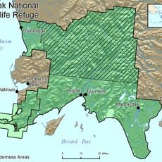
Aleutians East, Administrative division in southwestern Alaska, United States.

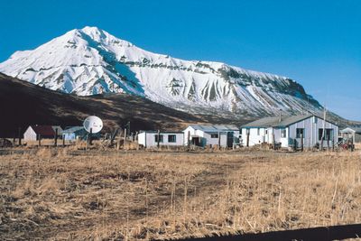
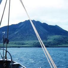
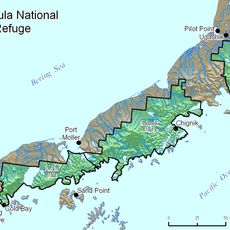
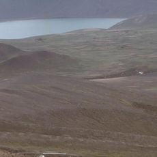
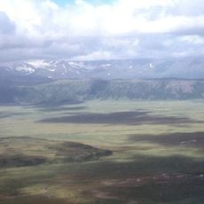
Aleutians East is an administrative division in southwestern Alaska extending from the Alaska Peninsula to the eastern Aleutian Islands. The region spans both mainland and island territories with a rugged coastline and several communities that depend primarily on fishing.

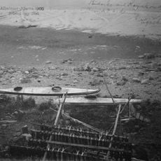
Russian fur traders first made contact with indigenous populations while hunting sea otters in the 1700s. European and Scandinavian fishermen arrived in the early 1900s and shaped the region's commercial fishing development.

The region maintains strong connections to Unangan heritage, with residents continuing fishing practices passed down through generations. This way of life shapes daily rhythms and shows how deeply local identity is tied to the sea.

Sand Point serves as the administrative hub where main services and the fishing fleet are based. Travel between communities relies mainly on boats and planes since roads do not connect the settlements.

The region experiences extreme weather conditions with long dark winters and brief summers that fundamentally shape daily life. This stark seasonality has led to distinctive ways of living and adapting that visitors notice right away.

The community of curious travelers

AroundUs brings together thousands of curated places, local tips, and hidden gems, enriched daily by 60,000 contributors worldwide.

Start exploring
GPS coordinates
55.05124,-162.89169
Latest update
December 7, 2025 19:24
Around this place
Mount Shishaldin
United States of America

Mount Shishaldin

76.4 km
Mount Pavlof
United States of America

Mount Pavlof

75.3 km
Mount Okmok
United States of America

Mount Okmok

389.4 km
Dutch Harbor Naval Operating Base and Fort Mears, U.S. Army
United States of America

Dutch Harbor Naval Operating Base and Fort Mears, U.S. Army

267.9 km
Mount Aniakchak
United States of America

Mount Aniakchak

357.2 km
Aniakchak National Monument and Preserve
United States of America

Aniakchak National Monument and Preserve

362.2 km
Mount Veniaminof
United States of America

Mount Veniaminof

254.3 km
Mount Akutan
United States of America

Mount Akutan

224.2 km
Makushin Volcano
United States of America

Makushin Volcano

290.9 km
SS Northwestern
United States of America

SS Northwestern

276.4 km
Izembek National Wildlife Refuge
United States of America

Izembek National Wildlife Refuge

23.9 km
Amak Volcano
United States of America

Amak Volcano

44 km
Mount Chiginagak
United States of America

Mount Chiginagak

433.4 km
Alaska Peninsula National Wildlife Refuge
United States of America

Alaska Peninsula National Wildlife Refuge

266.9 km
Cape Field at Fort Glenn
United States of America

Cape Field at Fort Glenn

374.8 km
Togiak National Wildlife Refuge
United States of America

Togiak National Wildlife Refuge

502.5 km
Fisher Caldera
United States of America

Fisher Caldera

104.7 km
Cape Sarichef Light
United States of America

Cape Sarichef Light

140 km
Pavlof Sister
United States of America

Pavlof Sister

79.9 km
Mount Dutton
United States of America

Mount Dutton

41.5 km
Cold Bay Volcano
United States of America

Cold Bay Volcano

4 km
Mount Emmons
United States of America

Mount Emmons

61.2 km
Mount Dana
United States of America

Mount Dana

124.5 km
Bogoslof Wilderness
United States of America

Bogoslof Wilderness

355.1 km
Mount Gilbert
United States of America

Mount Gilbert

199.3 km
Izembek Wilderness
United States of America

Izembek Wilderness

30.6 km
Ugashik River
United States of America

Ugashik River

448.2 km
Frosty Volcano
United States of America

Frosty Volcano

6 km
Show the full map
« Aleutians East - Administrative division in southwestern Alaska, United States » is provided by Around Us (aroundus.com). Images and texts are derived from Wikimedia project under a Creative Commons license. You are allowed to copy, distribute, and modify copies of this page, under the conditions set by the license, as long as this note is clearly visible.

Discover hidden gems everywhere you go!

From secret cafés to breathtaking viewpoints, skip the crowded tourist spots and find places that match your style. Our app makes it easy with voice search, smart filtering, route optimization, and insider tips from travelers worldwide. Download now for the complete mobile experience.

Around Us App Screenshot

A unique approach to discovering new places

Le Figaro

All the places worth exploring

France Info

A tailor-made excursion in just a few clicks

20 Minutes

Around Us
Travel Guide & Maps
Download

Send to your phone

QR Code
1

Open the camera app on your mobile.

2

Point at the QR code with your camera. A notification will appear.

3

Tap the notification to open the link.