See the monuments around you in AROpen chests in the app
Around Us is built for your phone — point your camera at the streets and discover the monuments and places around you in augmented reality.Around Us is built for your phone — chests unlock when you walk, explore and capture nearby places.
Visiting Bolivia: natural landscapes, archaeological sites, and colonial heritage
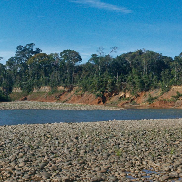
Bolivia sits in the central Andes, linking mountain ranges, high plateau lands, and lowland rainforests in a landlocked country. The changes in altitude create different climate zones and landscapes, from snow-covered peaks to tropical vegetation. Many visitors start in La Paz, a city that clings to a canyon and where a cable car system moves traffic between neighborhoods. The colonial capital of Sucre preserves its white facades and courtyards from the 1600s, while Potosí sits at the foot of Cerro Rico, a mountain that saw centuries of silver mining.
The natural sites range from Lake Titicaca on the Peruvian border to the Salar de Uyuni, an expansive salt flat that turns into a shallow mirror during the rainy season. Madidi National Park protects rainforest in the north, while the Eduardo Avaroa Reserve in the south shows colored lagoons and desert formations. The Tiwanaku archaeological site holds evidence of pre-Columbian civilizations, and the Jesuit Missions of Chiquitos are wooden churches that survive in remote towns. The Valley of the Moon near La Paz forms eroded rocks that resemble lunar landscapes, and Torotoro National Park contains fossils and dinosaur tracks. The journey from La Paz to Coroico passes along the Death Road, a narrow mountain route that descends into the Yungas lowlands.
Visiting Bolivia: natural landscapes, archaeological sites, and colonial heritage
Bolivia sits in the central Andes, linking mountain ranges, high plateau lands, and lowland rainforests in a landlocked country. The changes in altitude create different climate zones and landscapes, from snow-covered peaks to tropical vegetation. Many visitors start in La Paz, a city that clings to a canyon and where a cable car system moves traffic between neighborhoods. The colonial capital of Sucre preserves its white facades and courtyards from the 1600s, while Potosí sits at the foot of Cerro Rico, a mountain that saw centuries of silver mining.
The natural sites range from Lake Titicaca on the Peruvian border to the Salar de Uyuni, an expansive salt flat that turns into a shallow mirror during the rainy season. Madidi National Park protects rainforest in the north, while the Eduardo Avaroa Reserve in the south shows colored lagoons and desert formations. The Tiwanaku archaeological site holds evidence of pre-Columbian civilizations, and the Jesuit Missions of Chiquitos are wooden churches that survive in remote towns. The Valley of the Moon near La Paz forms eroded rocks that resemble lunar landscapes, and Torotoro National Park contains fossils and dinosaur tracks. The journey from La Paz to Coroico passes along the Death Road, a narrow mountain route that descends into the Yungas lowlands.
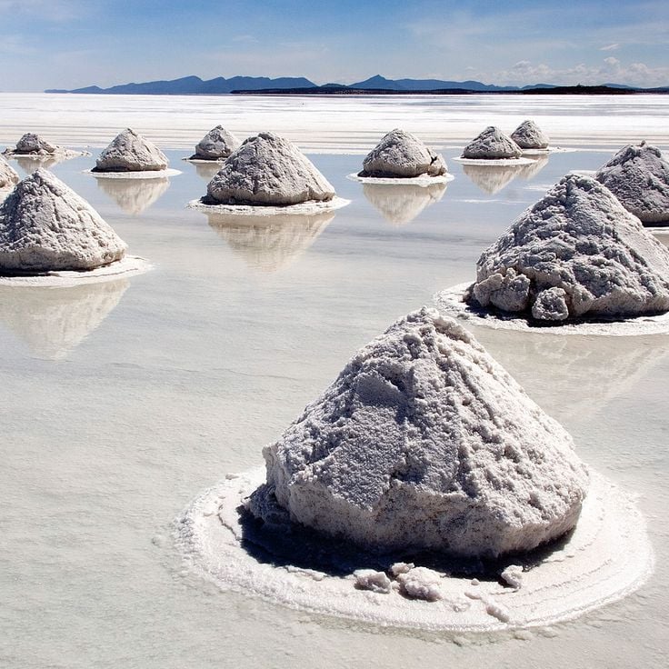
The Salar de Uyuni sits on the Bolivian Altiplano at an altitude of over 12,000 feet (3,600 meters). This salt desert formed through the evaporation of a prehistoric lake and now constitutes the largest salt flat on Earth. The salt crust reaches a thickness of 33 feet (10 meters) in some areas. During the rainy season, the Salar transforms into a vast mirror that reflects the sky. The region contains significant lithium deposits and serves as a breeding ground for several flamingo species. This site combines the geological history of Bolivia with its extraordinary natural landscapes.
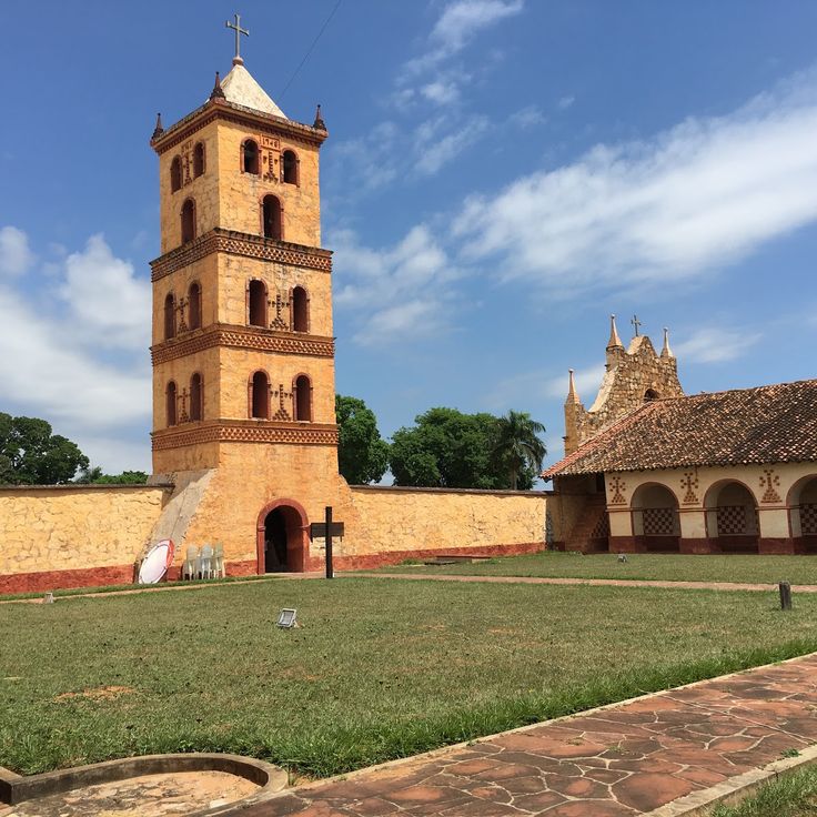
These reductions in the lowlands east of Santa Cruz were built between the late 1600s and mid-1700s, when Jesuits worked with Chiquitano communities. The church complexes combine European building techniques with local materials and methods. You find wooden structures, painted interiors, and carved columns. Musical practices from the Jesuit period are still maintained in the communities. The six sites of San Xavier, Concepción, Santa Ana, San Miguel, San Rafael, and San José were declared a UNESCO World Heritage Site in 1990 and attract visitors interested in religious architecture and cultural continuity.
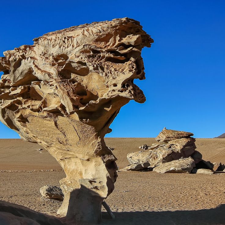
This high-altitude desert sits at 15,420 feet (4,700 meters) in the Andes. The Siloli Desert shows rock formations shaped by wind and sharp temperature changes. Mineral-rich rocks define the terrain. Only a few plant species can survive under these extreme conditions. Erosion has created structures that spread across wide areas.
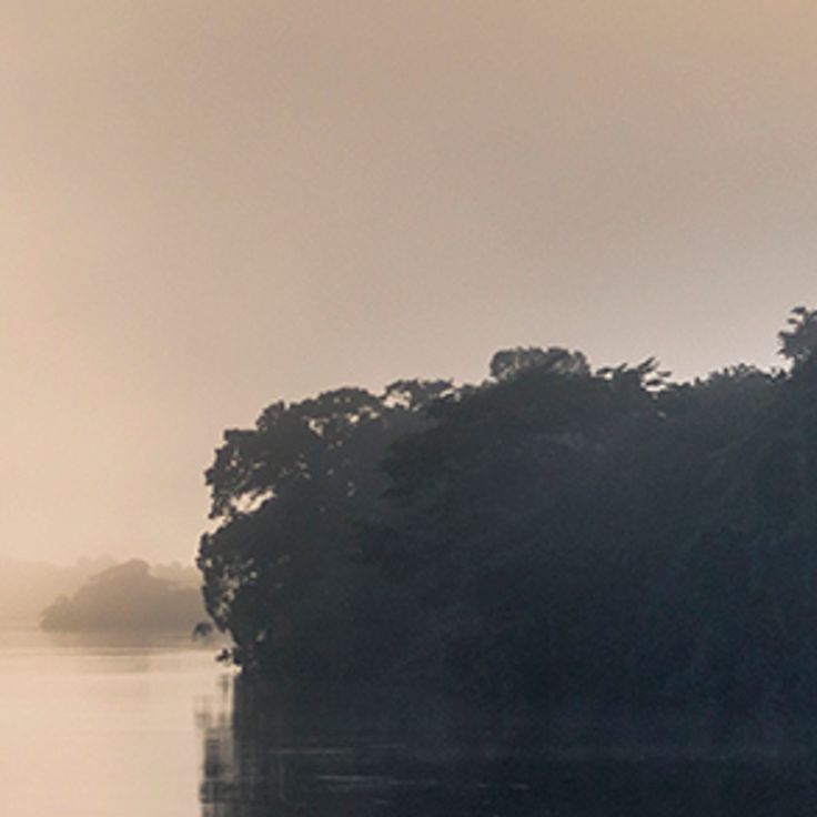
This national park protects one of the more intact parts of the Amazon basin, where table mountains, rainforest, savannas, and waterfalls meet. Jaguars, pumas, tapirs, and several monkey species live here among a diversity of plants and birds. The waterfalls, including Arco Iris at about 88 meters (289 feet) high, drop over rock walls that trace back to Precambrian times. The place is remote and usually reached by air or river.
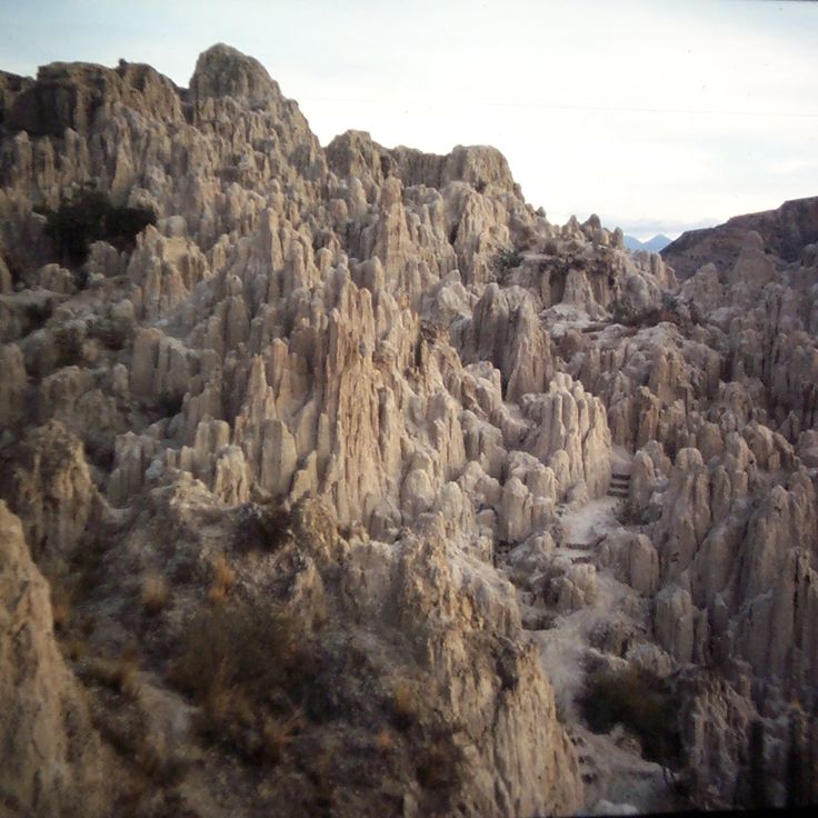
This valley extends across the southern part of La Paz and shows terrain shaped over millennia by erosion acting on clay and sandstone deposits. Water erosion has created an unusual landscape with tower-shaped rock formations, deep ravines and labyrinth-like structures. The eroded surfaces of these geological formations resemble lunar topography and offer insights into layers of geological history.
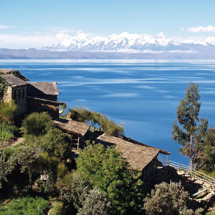
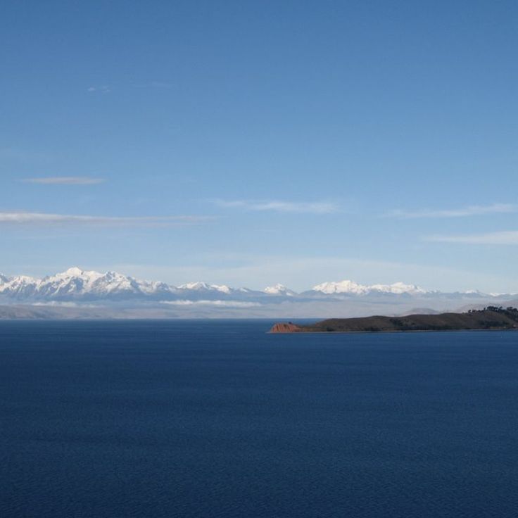
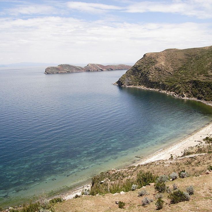
This lake sits at 12,500 feet (3,812 meters) altitude and is the largest navigable lake in South America. It stretches across the border between Peru and Bolivia, and its islands preserve archaeological remains from the Inca period, including temples and ceremonial sites. Aymara and Quechua communities live along the shores and on the islands, maintaining traditional agriculture, fishing, and textile crafts. Isla del Sol holds sacred status in Inca mythology and shows ruins of religious complexes. The deep blue water contrasts with the surrounding Andean ranges.
This reserve protects a volcanic landscape at over 13,000 feet (4,000 meters) near the Chilean and Argentine borders. Visitors find hot springs, active geysers, and several salt lakes colored by minerals—white, green, and red. Three flamingo species live in these waters, feeding on algae and microorganisms. The terrain stretches across a barren, windy plateau where the air is thin and temperatures drop sharply at night.
This archaeological site was the religious and administrative center of a pre-Hispanic civilization that flourished between 300 and 1000 AD. Tiwanaku sits in the Andean highlands at about 12,800 feet (3,900 meters) above sea level and displays with the Gateway of the Sun, the Akapana pyramid, and the Kalasasaya platform the technical and artistic abilities of this culture. The monumental stone sculptures and structures document the ritual importance of this place to the people of the region.
This national park covers about 1.9 million hectares and protects different habitats that reach from the tropical lowland forests of the Amazon basin to the glaciated peaks of the Andes. The area is home to more than 1000 bird species, around 200 mammal species, and several thousand plant species. The landscape shifts from dense rainforest with tall trees and lianas through cloud forests at middle elevations to bare rock and snowfields in the high mountains. Visitors move through different climate zones and vegetation types within a relatively compact space.
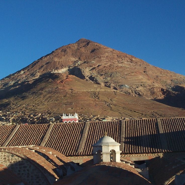
Cerro Rico Mountain rises above the city of Potosí at an elevation of 4800 meters. This mountain stands as a central symbol of Bolivian colonial heritage, as silver ore has been mined from its tunnels since the 16th century. The mining operations continue to this day, even though working conditions inside remain very difficult. Visitors can take guided tours through some of the tunnels to learn about the history and current extraction methods used here.
This national park covers a dry region with high plateaus and a deep canyon. The area was once covered by sea, and sedimentary rocks preserve fossils of marine animals and tracks left by dinosaurs. Torotoro also protects cave systems that extend through the limestone and several waterfalls that flow during the rainy season.
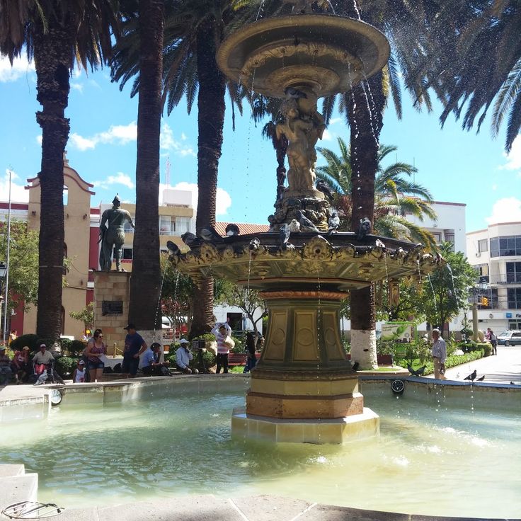
Sucre is the constitutional capital of Bolivia and shows colonial heritage from the Spanish period through churches, monasteries and administrative buildings. This city preserves the architectural development from the 16th to the 18th century in its historic center. The Casa de la Libertad is the place where the declaration of independence was signed in 1825. The Cathedral of Sucre dates from the 16th century and houses religious artworks. The streets are lined with white buildings that gave Sucre its nickname of the white city.
The Royal Cordillera stretches northeast of La Paz for about 125 kilometers, forming part of the Bolivian Andes. Six peaks in this mountain range rise above 6000 meters (19,700 feet), including Illimani and Illampu. Historic Inca trade routes cross through the mountains, connecting the highlands with the eastern lowlands. Glaciers cover the higher elevations, while rivers flow through the valleys, contributing to the water supply of surrounding communities.
Amboró National Park sits where the Amazon rainforest meets the foothills of the Andes. This protected area is home to over 830 bird species, making it one of the regions with the highest bird density in South America. The park's position between different ecosystems explains this exceptional variety of life, which also includes many mammals, reptiles and amphibians.
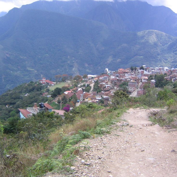
Coroico sits in the yungas region at 5,577 feet (1,700 meters), where residents grow coffee and citrus fruits on mountain slopes. This town serves as a starting point for hikes into the surrounding tropical valleys and offers a temperature contrast with the highlands near La Paz. The road from La Paz to Coroico passes through different climate zones and vegetation levels, connecting the high plateau with the slopes where the climate becomes warmer and more humid.
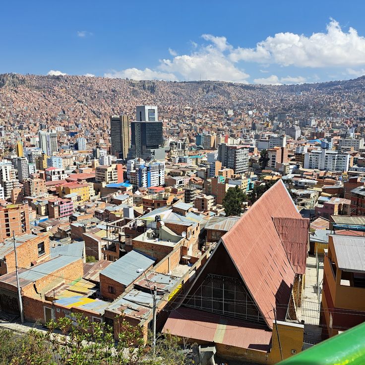
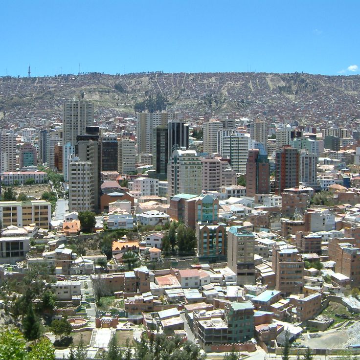
La Paz sits in an Andean valley at 3,650 meters (about 12,000 feet) elevation and serves as Bolivia's governmental seat. This city extends between the peaks of the Cordillera Real and houses the executive and legislative branches of the country. Streets climb steep slopes while the center combines busy markets with colonial buildings. The Teleférico cable car network connects different neighborhoods and offers views of the surrounding mountains. La Paz serves as a starting point for trips to Lake Titicaca and the Yungas valleys.
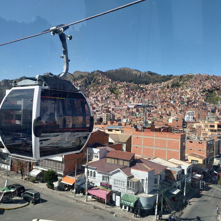
Mi Teleférico is a network of eleven cable car lines connecting La Paz with El Alto across an altitude difference of about 2,800 feet (850 meters). This transport system carries several hundred thousand passengers daily who travel between the two Bolivian cities for work, school, or daily errands. The cabins glide above neighborhoods, markets, and steep hillsides, offering views of the Andes and the dense construction of both urban areas. The first line opened in 2014, with others added in the following years.
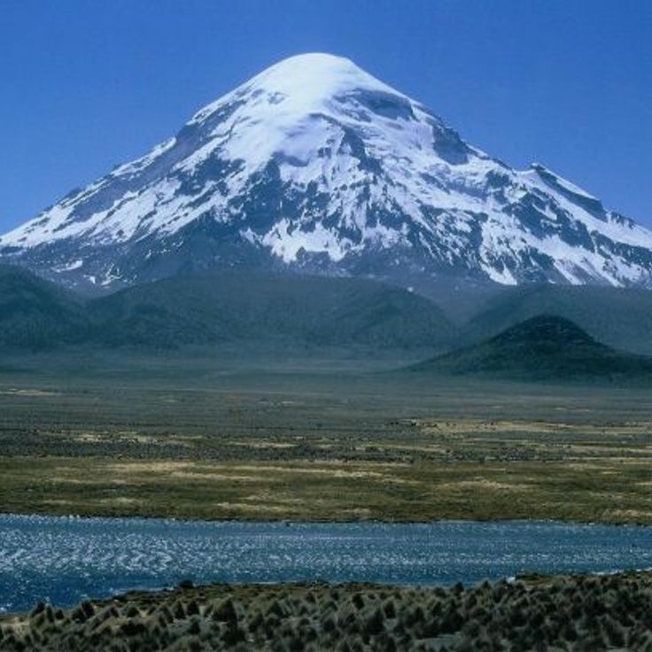
Sajama National Park stretches around the volcano of the same name, which at 21,460 feet (6,542 meters) forms the highest peak in Bolivia. This protected area includes wide high plateaus above 13,100 feet (4,000 meters) and numerous geothermal zones with active geysers and hot springs. The landscape shows queñua forests, among the highest tree formations in the world.
Tarija is a 16th-century city that has become a trade center and Bolivia's main wine region. Wine has been grown here since colonial times, and many bodegas produce different varieties that have given the region its reputation as a wine country. The mild climate and altitude of 6070 feet (1850 meters) support cultivation.
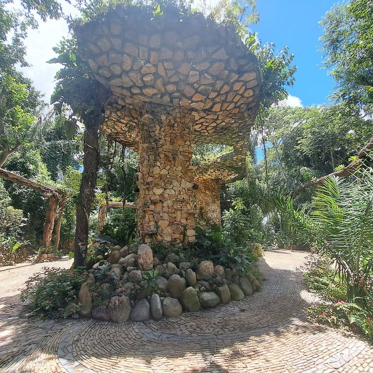
This ecological garden lies in the lowlands near Santa Cruz and focuses on the conservation of tropical plant life. The Biocentro Güembé is home to orchids, butterflies, and palms native to this warm region. Visitors can walk along landscaped paths through the grounds and observe various plant species from the Bolivian lowlands. There are also pools for swimming and shaded areas for resting.
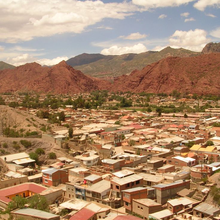
Tupiza developed as a mining center within a landscape of red sandstone carved by canyons and unusual rock formations. The town's residents cultivate the surrounding valleys, growing agricultural products on fertile soils. This region served as a historical refuge for Butch Cassidy and the Sundance Kid, connecting Bolivian history with tales of the American West.
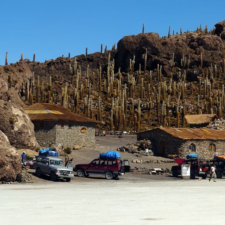
Incahuasi Island rises as a limestone formation from the center of the Uyuni salt flat. On this rocky outcrop grow several hundred columnar cacti belonging to the Echinopsis genus, which can live for several hundred years. Some of these cacti exceed 33 feet (10 meters) in height. From the highest point of the island, the white expanse of Salar de Uyuni extends in all directions to the horizon.
This market takes place every Sunday and brings together residents from surrounding villages who offer agricultural products, woven goods and handicrafts. The communities wear their traditional dress, including embroidered hats and woven ponchos. Tarabuco serves as a commercial center and a social gathering point for the indigenous groups of the region, preserving traditions in the Bolivian highlands.
This island is the largest in Lake Titicaca and holds many traces of Inca culture. Agricultural terraces from pre-Hispanic times spread across the surface, along with several temple ruins and a network of paths linking small villages where residents still follow traditional ways of life. Walking across the island you meet herders tending sheep and fields of corn and quinoa. The air is thin at almost 13,000 feet (4,000 meters) above sea level, and the lake spreads in all directions toward distant Andean peaks.
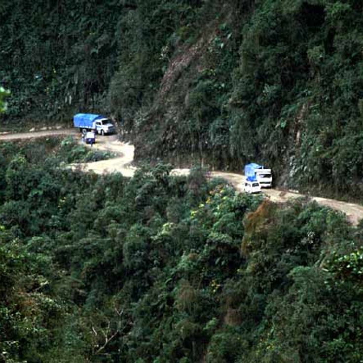
This mountain road links La Paz to Coroico and winds through cloud forest and rock faces. The route passes through a valley with narrow sections, steep curves, and cliff walls on one side. Many cyclists now ride the stretch that was once a main transport route. Views extend over canyons and vegetation that shifts with elevation.
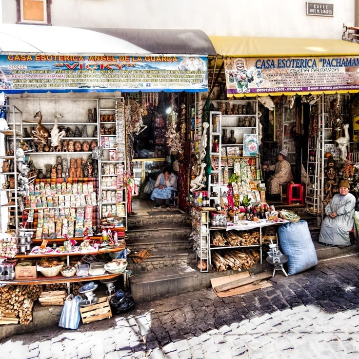
This market sits on Melchor Jiménez Street and forms a commercial district for traditional medicine. It sells medicinal plants, amulets and ritual objects from Andean culture used in local cultural practices. Vendors offer dried frogs, llama fetuses and various herbs employed in Aymara folk medicine. This market serves both local residents and shamans who purchase materials for traditional ceremonies here.
Laguna Colorada sits on the Bolivian Altiplano at over 14,000 feet (4,300 meters). The water in this salt lake appears red, caused by iron sediments and pigmented algae. Large colonies of Andean flamingos live here and feed on microorganisms in the water. The color of the water changes with the light, ranging from deep red to orange. This lagoon is one of the natural highlights of Bolivia and shows the unusual landscape of the high plateau.
This cathedral was built between 1915 and 1925 and shows an architecture that reflects the religious heritage of Bolivia. The building has a central nave with ceilings made from local wood and colored glass windows that define the interior. The Santa Cruz Cathedral stands in the heart of the city and serves as a place for services and religious celebrations. Visitors can experience the atmosphere of the space, where light passes through the windows and the wooden ceiling shows the connection to regional craft tradition.
This fort is an archaeological site dating from around 300 BC. At this site there is a carved sandstone formation roughly 250 meters (820 feet) long. Geometric patterns and animal figures have been carved into the stone by peoples who lived here before the Spanish arrived. The fort served religious and ceremonial purposes. The Inca later expanded it.
This religious monument, built in 1994, stands on San Pedro hill overlooking the city and valley of Cochabamba. The Christ of Concord rises 40 meters (130 feet) tall, with arms spanning about 34 meters (112 feet) at the base. The sculpture depicts Jesus Christ with open arms in a gesture of embrace. Visitors can reach the statue via a long outdoor staircase of 2000 steps or by taking a cable car, and from the top they can enjoy views over the entire valley.
This museum displays a collection of silver minerals and valuable objects extracted from the Cerro Rico mines. The exhibits are housed in an 18th-century colonial building that documents the historical significance of silver mining in Potosí. Visitors can view various silver ores, coins, and liturgical objects that illustrate the wealth of the region during the Spanish colonial period.
The National Museum of Ethnography in La Paz displays textiles, masks, ceramics and ritual objects from the indigenous communities of Bolivia. This museum presents artifacts spanning from pre-Columbian times to the present day, documenting the daily life, ceremonies and artistic traditions of these peoples. The exhibition allows visitors to understand the cultural continuity of the country's indigenous groups.
This church was built in the 16th century and shows a baroque facade carved from stone. Inside there are gilded altars and murals that combine Catholic symbols with motifs from indigenous cultures. The church is part of the colonial heritage of La Paz and tells the story of the religious history of the region, where European traditions met local beliefs.
This viewpoint sits at 3600 meters (11,811 feet) altitude and opens up the view over La Paz, with its densely built slopes, the surrounding Andean peaks, and the 6438-meter (21,122 feet) Mount Illimani rising over the city. From here you can see the valley where Bolivia's administrative capital extends, and observe the steep residential neighborhoods climbing from the basin up toward the Altiplano.
The Salar de Uyuni sits on the Bolivian Altiplano at an altitude of over 12,000 feet (3,600 meters). This salt desert formed through the evaporation of a prehistoric lake and now constitutes the largest salt flat on Earth. The salt crust reaches a thickness of 33 feet (10 meters) in some areas. During the rainy season, the Salar transforms into a vast mirror that reflects the sky. The region contains significant lithium deposits and serves as a breeding ground for several flamingo species. This site combines the geological history of Bolivia with its extraordinary natural landscapes.
These reductions in the lowlands east of Santa Cruz were built between the late 1600s and mid-1700s, when Jesuits worked with Chiquitano communities. The church complexes combine European building techniques with local materials and methods. You find wooden structures, painted interiors, and carved columns. Musical practices from the Jesuit period are still maintained in the communities. The six sites of San Xavier, Concepción, Santa Ana, San Miguel, San Rafael, and San José were declared a UNESCO World Heritage Site in 1990 and attract visitors interested in religious architecture and cultural continuity.
This high-altitude desert sits at 15,420 feet (4,700 meters) in the Andes. The Siloli Desert shows rock formations shaped by wind and sharp temperature changes. Mineral-rich rocks define the terrain. Only a few plant species can survive under these extreme conditions. Erosion has created structures that spread across wide areas.
This national park protects one of the more intact parts of the Amazon basin, where table mountains, rainforest, savannas, and waterfalls meet. Jaguars, pumas, tapirs, and several monkey species live here among a diversity of plants and birds. The waterfalls, including Arco Iris at about 88 meters (289 feet) high, drop over rock walls that trace back to Precambrian times. The place is remote and usually reached by air or river.
This valley extends across the southern part of La Paz and shows terrain shaped over millennia by erosion acting on clay and sandstone deposits. Water erosion has created an unusual landscape with tower-shaped rock formations, deep ravines and labyrinth-like structures. The eroded surfaces of these geological formations resemble lunar topography and offer insights into layers of geological history.
This lake sits at 12,500 feet (3,812 meters) altitude and is the largest navigable lake in South America. It stretches across the border between Peru and Bolivia, and its islands preserve archaeological remains from the Inca period, including temples and ceremonial sites. Aymara and Quechua communities live along the shores and on the islands, maintaining traditional agriculture, fishing, and textile crafts. Isla del Sol holds sacred status in Inca mythology and shows ruins of religious complexes. The deep blue water contrasts with the surrounding Andean ranges.
This reserve protects a volcanic landscape at over 13,000 feet (4,000 meters) near the Chilean and Argentine borders. Visitors find hot springs, active geysers, and several salt lakes colored by minerals—white, green, and red. Three flamingo species live in these waters, feeding on algae and microorganisms. The terrain stretches across a barren, windy plateau where the air is thin and temperatures drop sharply at night.
This archaeological site was the religious and administrative center of a pre-Hispanic civilization that flourished between 300 and 1000 AD. Tiwanaku sits in the Andean highlands at about 12,800 feet (3,900 meters) above sea level and displays with the Gateway of the Sun, the Akapana pyramid, and the Kalasasaya platform the technical and artistic abilities of this culture. The monumental stone sculptures and structures document the ritual importance of this place to the people of the region.
This national park covers about 1.9 million hectares and protects different habitats that reach from the tropical lowland forests of the Amazon basin to the glaciated peaks of the Andes. The area is home to more than 1000 bird species, around 200 mammal species, and several thousand plant species. The landscape shifts from dense rainforest with tall trees and lianas through cloud forests at middle elevations to bare rock and snowfields in the high mountains. Visitors move through different climate zones and vegetation types within a relatively compact space.
Cerro Rico Mountain rises above the city of Potosí at an elevation of 4800 meters. This mountain stands as a central symbol of Bolivian colonial heritage, as silver ore has been mined from its tunnels since the 16th century. The mining operations continue to this day, even though working conditions inside remain very difficult. Visitors can take guided tours through some of the tunnels to learn about the history and current extraction methods used here.
This national park covers a dry region with high plateaus and a deep canyon. The area was once covered by sea, and sedimentary rocks preserve fossils of marine animals and tracks left by dinosaurs. Torotoro also protects cave systems that extend through the limestone and several waterfalls that flow during the rainy season.
Sucre is the constitutional capital of Bolivia and shows colonial heritage from the Spanish period through churches, monasteries and administrative buildings. This city preserves the architectural development from the 16th to the 18th century in its historic center. The Casa de la Libertad is the place where the declaration of independence was signed in 1825. The Cathedral of Sucre dates from the 16th century and houses religious artworks. The streets are lined with white buildings that gave Sucre its nickname of the white city.
The Royal Cordillera stretches northeast of La Paz for about 125 kilometers, forming part of the Bolivian Andes. Six peaks in this mountain range rise above 6000 meters (19,700 feet), including Illimani and Illampu. Historic Inca trade routes cross through the mountains, connecting the highlands with the eastern lowlands. Glaciers cover the higher elevations, while rivers flow through the valleys, contributing to the water supply of surrounding communities.
Amboró National Park sits where the Amazon rainforest meets the foothills of the Andes. This protected area is home to over 830 bird species, making it one of the regions with the highest bird density in South America. The park's position between different ecosystems explains this exceptional variety of life, which also includes many mammals, reptiles and amphibians.
Coroico sits in the yungas region at 5,577 feet (1,700 meters), where residents grow coffee and citrus fruits on mountain slopes. This town serves as a starting point for hikes into the surrounding tropical valleys and offers a temperature contrast with the highlands near La Paz. The road from La Paz to Coroico passes through different climate zones and vegetation levels, connecting the high plateau with the slopes where the climate becomes warmer and more humid.
La Paz sits in an Andean valley at 3,650 meters (about 12,000 feet) elevation and serves as Bolivia's governmental seat. This city extends between the peaks of the Cordillera Real and houses the executive and legislative branches of the country. Streets climb steep slopes while the center combines busy markets with colonial buildings. The Teleférico cable car network connects different neighborhoods and offers views of the surrounding mountains. La Paz serves as a starting point for trips to Lake Titicaca and the Yungas valleys.
Mi Teleférico is a network of eleven cable car lines connecting La Paz with El Alto across an altitude difference of about 2,800 feet (850 meters). This transport system carries several hundred thousand passengers daily who travel between the two Bolivian cities for work, school, or daily errands. The cabins glide above neighborhoods, markets, and steep hillsides, offering views of the Andes and the dense construction of both urban areas. The first line opened in 2014, with others added in the following years.
Sajama National Park stretches around the volcano of the same name, which at 21,460 feet (6,542 meters) forms the highest peak in Bolivia. This protected area includes wide high plateaus above 13,100 feet (4,000 meters) and numerous geothermal zones with active geysers and hot springs. The landscape shows queñua forests, among the highest tree formations in the world.
Tarija is a 16th-century city that has become a trade center and Bolivia's main wine region. Wine has been grown here since colonial times, and many bodegas produce different varieties that have given the region its reputation as a wine country. The mild climate and altitude of 6070 feet (1850 meters) support cultivation.
This ecological garden lies in the lowlands near Santa Cruz and focuses on the conservation of tropical plant life. The Biocentro Güembé is home to orchids, butterflies, and palms native to this warm region. Visitors can walk along landscaped paths through the grounds and observe various plant species from the Bolivian lowlands. There are also pools for swimming and shaded areas for resting.
Tupiza developed as a mining center within a landscape of red sandstone carved by canyons and unusual rock formations. The town's residents cultivate the surrounding valleys, growing agricultural products on fertile soils. This region served as a historical refuge for Butch Cassidy and the Sundance Kid, connecting Bolivian history with tales of the American West.
Incahuasi Island rises as a limestone formation from the center of the Uyuni salt flat. On this rocky outcrop grow several hundred columnar cacti belonging to the Echinopsis genus, which can live for several hundred years. Some of these cacti exceed 33 feet (10 meters) in height. From the highest point of the island, the white expanse of Salar de Uyuni extends in all directions to the horizon.
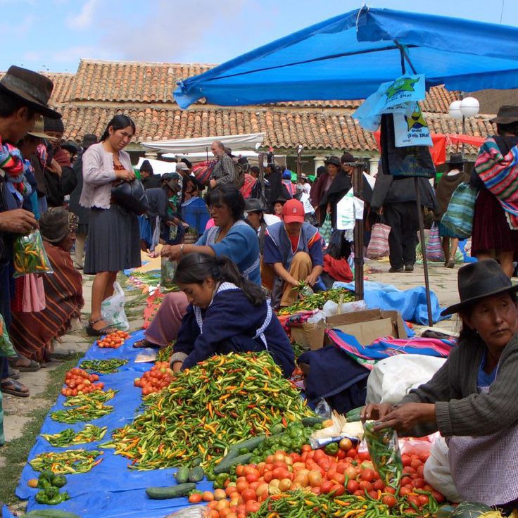
This market takes place every Sunday and brings together residents from surrounding villages who offer agricultural products, woven goods and handicrafts. The communities wear their traditional dress, including embroidered hats and woven ponchos. Tarabuco serves as a commercial center and a social gathering point for the indigenous groups of the region, preserving traditions in the Bolivian highlands.
This island is the largest in Lake Titicaca and holds many traces of Inca culture. Agricultural terraces from pre-Hispanic times spread across the surface, along with several temple ruins and a network of paths linking small villages where residents still follow traditional ways of life. Walking across the island you meet herders tending sheep and fields of corn and quinoa. The air is thin at almost 13,000 feet (4,000 meters) above sea level, and the lake spreads in all directions toward distant Andean peaks.
This mountain road links La Paz to Coroico and winds through cloud forest and rock faces. The route passes through a valley with narrow sections, steep curves, and cliff walls on one side. Many cyclists now ride the stretch that was once a main transport route. Views extend over canyons and vegetation that shifts with elevation.
This market sits on Melchor Jiménez Street and forms a commercial district for traditional medicine. It sells medicinal plants, amulets and ritual objects from Andean culture used in local cultural practices. Vendors offer dried frogs, llama fetuses and various herbs employed in Aymara folk medicine. This market serves both local residents and shamans who purchase materials for traditional ceremonies here.
Laguna Colorada sits on the Bolivian Altiplano at over 14,000 feet (4,300 meters). The water in this salt lake appears red, caused by iron sediments and pigmented algae. Large colonies of Andean flamingos live here and feed on microorganisms in the water. The color of the water changes with the light, ranging from deep red to orange. This lagoon is one of the natural highlights of Bolivia and shows the unusual landscape of the high plateau.
This cathedral was built between 1915 and 1925 and shows an architecture that reflects the religious heritage of Bolivia. The building has a central nave with ceilings made from local wood and colored glass windows that define the interior. The Santa Cruz Cathedral stands in the heart of the city and serves as a place for services and religious celebrations. Visitors can experience the atmosphere of the space, where light passes through the windows and the wooden ceiling shows the connection to regional craft tradition.
This fort is an archaeological site dating from around 300 BC. At this site there is a carved sandstone formation roughly 250 meters (820 feet) long. Geometric patterns and animal figures have been carved into the stone by peoples who lived here before the Spanish arrived. The fort served religious and ceremonial purposes. The Inca later expanded it.
This religious monument, built in 1994, stands on San Pedro hill overlooking the city and valley of Cochabamba. The Christ of Concord rises 40 meters (130 feet) tall, with arms spanning about 34 meters (112 feet) at the base. The sculpture depicts Jesus Christ with open arms in a gesture of embrace. Visitors can reach the statue via a long outdoor staircase of 2000 steps or by taking a cable car, and from the top they can enjoy views over the entire valley.
This museum displays a collection of silver minerals and valuable objects extracted from the Cerro Rico mines. The exhibits are housed in an 18th-century colonial building that documents the historical significance of silver mining in Potosí. Visitors can view various silver ores, coins, and liturgical objects that illustrate the wealth of the region during the Spanish colonial period.
The National Museum of Ethnography in La Paz displays textiles, masks, ceramics and ritual objects from the indigenous communities of Bolivia. This museum presents artifacts spanning from pre-Columbian times to the present day, documenting the daily life, ceremonies and artistic traditions of these peoples. The exhibition allows visitors to understand the cultural continuity of the country's indigenous groups.
This church was built in the 16th century and shows a baroque facade carved from stone. Inside there are gilded altars and murals that combine Catholic symbols with motifs from indigenous cultures. The church is part of the colonial heritage of La Paz and tells the story of the religious history of the region, where European traditions met local beliefs.
This viewpoint sits at 3600 meters (11,811 feet) altitude and opens up the view over La Paz, with its densely built slopes, the surrounding Andean peaks, and the 6438-meter (21,122 feet) Mount Illimani rising over the city. From here you can see the valley where Bolivia's administrative capital extends, and observe the steep residential neighborhoods climbing from the basin up toward the Altiplano.
The Salar de Uyuni sits on the Bolivian Altiplano at an altitude of over 12,000 feet (3,600 meters). This salt desert formed through the evaporation of a prehistoric lake and now constitutes the largest salt flat on Earth. The salt crust reaches a thickness of 33 feet (10 meters) in some areas. During the rainy season, the Salar transforms into a vast mirror that reflects the sky. The region contains significant lithium deposits and serves as a breeding ground for several flamingo species. This site combines the geological history of Bolivia with its extraordinary natural landscapes.
These reductions in the lowlands east of Santa Cruz were built between the late 1600s and mid-1700s, when Jesuits worked with Chiquitano communities. The church complexes combine European building techniques with local materials and methods. You find wooden structures, painted interiors, and carved columns. Musical practices from the Jesuit period are still maintained in the communities. The six sites of San Xavier, Concepción, Santa Ana, San Miguel, San Rafael, and San José were declared a UNESCO World Heritage Site in 1990 and attract visitors interested in religious architecture and cultural continuity.
This high-altitude desert sits at 15,420 feet (4,700 meters) in the Andes. The Siloli Desert shows rock formations shaped by wind and sharp temperature changes. Mineral-rich rocks define the terrain. Only a few plant species can survive under these extreme conditions. Erosion has created structures that spread across wide areas.
This national park protects one of the more intact parts of the Amazon basin, where table mountains, rainforest, savannas, and waterfalls meet. Jaguars, pumas, tapirs, and several monkey species live here among a diversity of plants and birds. The waterfalls, including Arco Iris at about 88 meters (289 feet) high, drop over rock walls that trace back to Precambrian times. The place is remote and usually reached by air or river.
This valley extends across the southern part of La Paz and shows terrain shaped over millennia by erosion acting on clay and sandstone deposits. Water erosion has created an unusual landscape with tower-shaped rock formations, deep ravines and labyrinth-like structures. The eroded surfaces of these geological formations resemble lunar topography and offer insights into layers of geological history.
This lake sits at 12,500 feet (3,812 meters) altitude and is the largest navigable lake in South America. It stretches across the border between Peru and Bolivia, and its islands preserve archaeological remains from the Inca period, including temples and ceremonial sites. Aymara and Quechua communities live along the shores and on the islands, maintaining traditional agriculture, fishing, and textile crafts. Isla del Sol holds sacred status in Inca mythology and shows ruins of religious complexes. The deep blue water contrasts with the surrounding Andean ranges.
This reserve protects a volcanic landscape at over 13,000 feet (4,000 meters) near the Chilean and Argentine borders. Visitors find hot springs, active geysers, and several salt lakes colored by minerals—white, green, and red. Three flamingo species live in these waters, feeding on algae and microorganisms. The terrain stretches across a barren, windy plateau where the air is thin and temperatures drop sharply at night.
This archaeological site was the religious and administrative center of a pre-Hispanic civilization that flourished between 300 and 1000 AD. Tiwanaku sits in the Andean highlands at about 12,800 feet (3,900 meters) above sea level and displays with the Gateway of the Sun, the Akapana pyramid, and the Kalasasaya platform the technical and artistic abilities of this culture. The monumental stone sculptures and structures document the ritual importance of this place to the people of the region.
This national park covers about 1.9 million hectares and protects different habitats that reach from the tropical lowland forests of the Amazon basin to the glaciated peaks of the Andes. The area is home to more than 1000 bird species, around 200 mammal species, and several thousand plant species. The landscape shifts from dense rainforest with tall trees and lianas through cloud forests at middle elevations to bare rock and snowfields in the high mountains. Visitors move through different climate zones and vegetation types within a relatively compact space.
Cerro Rico Mountain rises above the city of Potosí at an elevation of 4800 meters. This mountain stands as a central symbol of Bolivian colonial heritage, as silver ore has been mined from its tunnels since the 16th century. The mining operations continue to this day, even though working conditions inside remain very difficult. Visitors can take guided tours through some of the tunnels to learn about the history and current extraction methods used here.
This national park covers a dry region with high plateaus and a deep canyon. The area was once covered by sea, and sedimentary rocks preserve fossils of marine animals and tracks left by dinosaurs. Torotoro also protects cave systems that extend through the limestone and several waterfalls that flow during the rainy season.
Sucre is the constitutional capital of Bolivia and shows colonial heritage from the Spanish period through churches, monasteries and administrative buildings. This city preserves the architectural development from the 16th to the 18th century in its historic center. The Casa de la Libertad is the place where the declaration of independence was signed in 1825. The Cathedral of Sucre dates from the 16th century and houses religious artworks. The streets are lined with white buildings that gave Sucre its nickname of the white city.
The Royal Cordillera stretches northeast of La Paz for about 125 kilometers, forming part of the Bolivian Andes. Six peaks in this mountain range rise above 6000 meters (19,700 feet), including Illimani and Illampu. Historic Inca trade routes cross through the mountains, connecting the highlands with the eastern lowlands. Glaciers cover the higher elevations, while rivers flow through the valleys, contributing to the water supply of surrounding communities.
Amboró National Park sits where the Amazon rainforest meets the foothills of the Andes. This protected area is home to over 830 bird species, making it one of the regions with the highest bird density in South America. The park's position between different ecosystems explains this exceptional variety of life, which also includes many mammals, reptiles and amphibians.
Coroico sits in the yungas region at 5,577 feet (1,700 meters), where residents grow coffee and citrus fruits on mountain slopes. This town serves as a starting point for hikes into the surrounding tropical valleys and offers a temperature contrast with the highlands near La Paz. The road from La Paz to Coroico passes through different climate zones and vegetation levels, connecting the high plateau with the slopes where the climate becomes warmer and more humid.
La Paz sits in an Andean valley at 3,650 meters (about 12,000 feet) elevation and serves as Bolivia's governmental seat. This city extends between the peaks of the Cordillera Real and houses the executive and legislative branches of the country. Streets climb steep slopes while the center combines busy markets with colonial buildings. The Teleférico cable car network connects different neighborhoods and offers views of the surrounding mountains. La Paz serves as a starting point for trips to Lake Titicaca and the Yungas valleys.
Mi Teleférico is a network of eleven cable car lines connecting La Paz with El Alto across an altitude difference of about 2,800 feet (850 meters). This transport system carries several hundred thousand passengers daily who travel between the two Bolivian cities for work, school, or daily errands. The cabins glide above neighborhoods, markets, and steep hillsides, offering views of the Andes and the dense construction of both urban areas. The first line opened in 2014, with others added in the following years.
Sajama National Park stretches around the volcano of the same name, which at 21,460 feet (6,542 meters) forms the highest peak in Bolivia. This protected area includes wide high plateaus above 13,100 feet (4,000 meters) and numerous geothermal zones with active geysers and hot springs. The landscape shows queñua forests, among the highest tree formations in the world.
Tarija is a 16th-century city that has become a trade center and Bolivia's main wine region. Wine has been grown here since colonial times, and many bodegas produce different varieties that have given the region its reputation as a wine country. The mild climate and altitude of 6070 feet (1850 meters) support cultivation.
This ecological garden lies in the lowlands near Santa Cruz and focuses on the conservation of tropical plant life. The Biocentro Güembé is home to orchids, butterflies, and palms native to this warm region. Visitors can walk along landscaped paths through the grounds and observe various plant species from the Bolivian lowlands. There are also pools for swimming and shaded areas for resting.
Tupiza developed as a mining center within a landscape of red sandstone carved by canyons and unusual rock formations. The town's residents cultivate the surrounding valleys, growing agricultural products on fertile soils. This region served as a historical refuge for Butch Cassidy and the Sundance Kid, connecting Bolivian history with tales of the American West.
Incahuasi Island rises as a limestone formation from the center of the Uyuni salt flat. On this rocky outcrop grow several hundred columnar cacti belonging to the Echinopsis genus, which can live for several hundred years. Some of these cacti exceed 33 feet (10 meters) in height. From the highest point of the island, the white expanse of Salar de Uyuni extends in all directions to the horizon.
This market takes place every Sunday and brings together residents from surrounding villages who offer agricultural products, woven goods and handicrafts. The communities wear their traditional dress, including embroidered hats and woven ponchos. Tarabuco serves as a commercial center and a social gathering point for the indigenous groups of the region, preserving traditions in the Bolivian highlands.
This island is the largest in Lake Titicaca and holds many traces of Inca culture. Agricultural terraces from pre-Hispanic times spread across the surface, along with several temple ruins and a network of paths linking small villages where residents still follow traditional ways of life. Walking across the island you meet herders tending sheep and fields of corn and quinoa. The air is thin at almost 13,000 feet (4,000 meters) above sea level, and the lake spreads in all directions toward distant Andean peaks.
This mountain road links La Paz to Coroico and winds through cloud forest and rock faces. The route passes through a valley with narrow sections, steep curves, and cliff walls on one side. Many cyclists now ride the stretch that was once a main transport route. Views extend over canyons and vegetation that shifts with elevation.
This market sits on Melchor Jiménez Street and forms a commercial district for traditional medicine. It sells medicinal plants, amulets and ritual objects from Andean culture used in local cultural practices. Vendors offer dried frogs, llama fetuses and various herbs employed in Aymara folk medicine. This market serves both local residents and shamans who purchase materials for traditional ceremonies here.
Laguna Colorada sits on the Bolivian Altiplano at over 14,000 feet (4,300 meters). The water in this salt lake appears red, caused by iron sediments and pigmented algae. Large colonies of Andean flamingos live here and feed on microorganisms in the water. The color of the water changes with the light, ranging from deep red to orange. This lagoon is one of the natural highlights of Bolivia and shows the unusual landscape of the high plateau.
This cathedral was built between 1915 and 1925 and shows an architecture that reflects the religious heritage of Bolivia. The building has a central nave with ceilings made from local wood and colored glass windows that define the interior. The Santa Cruz Cathedral stands in the heart of the city and serves as a place for services and religious celebrations. Visitors can experience the atmosphere of the space, where light passes through the windows and the wooden ceiling shows the connection to regional craft tradition.
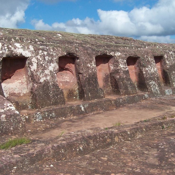
This fort is an archaeological site dating from around 300 BC. At this site there is a carved sandstone formation roughly 250 meters (820 feet) long. Geometric patterns and animal figures have been carved into the stone by peoples who lived here before the Spanish arrived. The fort served religious and ceremonial purposes. The Inca later expanded it.
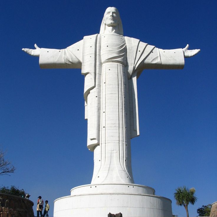
This religious monument, built in 1994, stands on San Pedro hill overlooking the city and valley of Cochabamba. The Christ of Concord rises 40 meters (130 feet) tall, with arms spanning about 34 meters (112 feet) at the base. The sculpture depicts Jesus Christ with open arms in a gesture of embrace. Visitors can reach the statue via a long outdoor staircase of 2000 steps or by taking a cable car, and from the top they can enjoy views over the entire valley.
This museum displays a collection of silver minerals and valuable objects extracted from the Cerro Rico mines. The exhibits are housed in an 18th-century colonial building that documents the historical significance of silver mining in Potosí. Visitors can view various silver ores, coins, and liturgical objects that illustrate the wealth of the region during the Spanish colonial period.
The National Museum of Ethnography in La Paz displays textiles, masks, ceramics and ritual objects from the indigenous communities of Bolivia. This museum presents artifacts spanning from pre-Columbian times to the present day, documenting the daily life, ceremonies and artistic traditions of these peoples. The exhibition allows visitors to understand the cultural continuity of the country's indigenous groups.
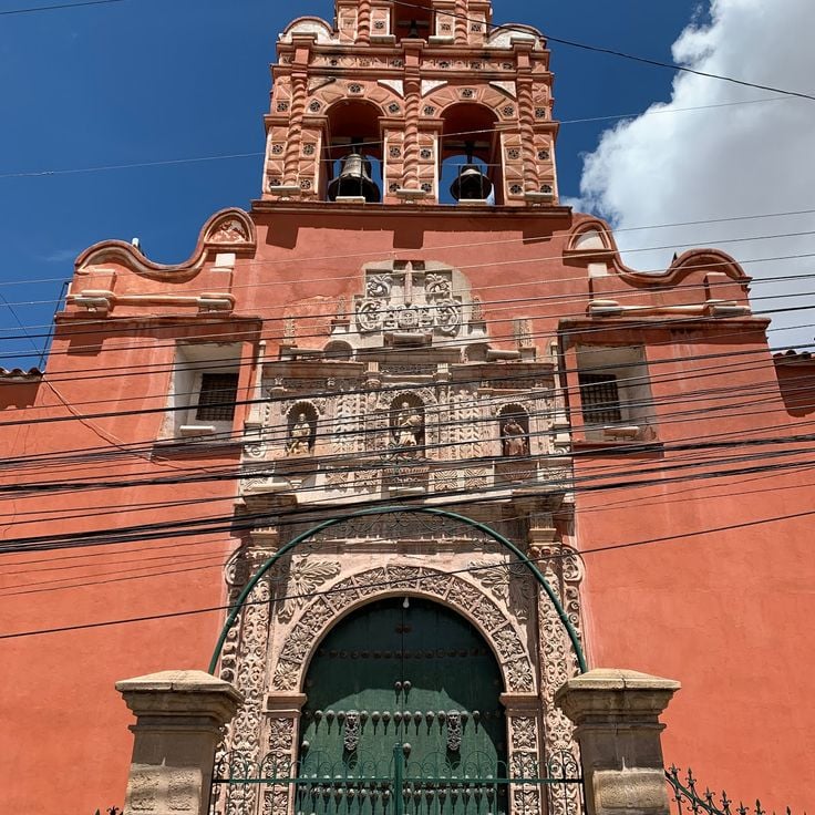
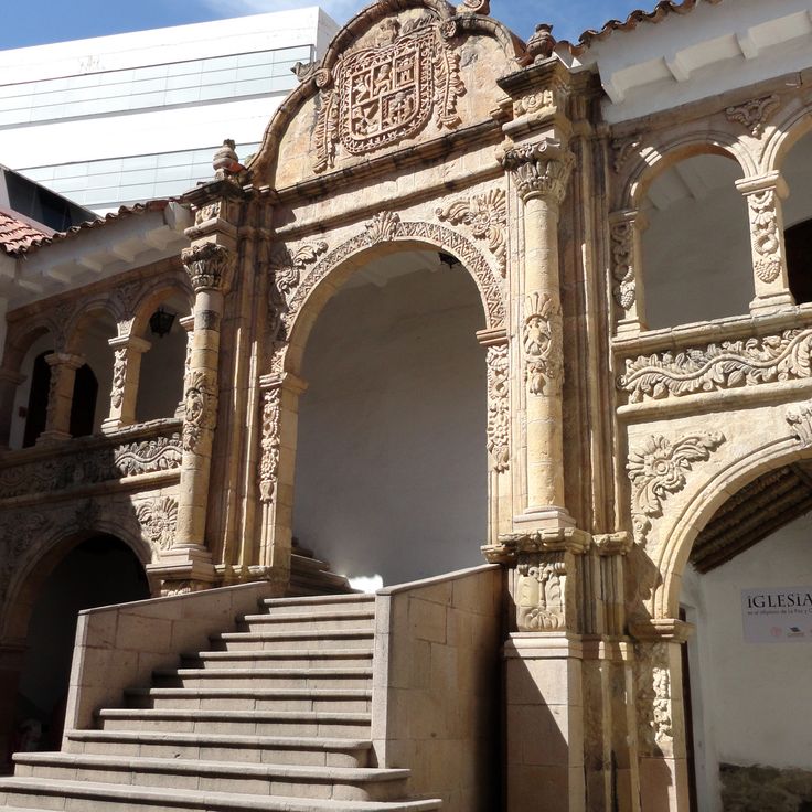
This church was built in the 16th century and shows a baroque facade carved from stone. Inside there are gilded altars and murals that combine Catholic symbols with motifs from indigenous cultures. The church is part of the colonial heritage of La Paz and tells the story of the religious history of the region, where European traditions met local beliefs.
This viewpoint sits at 3600 meters (11,811 feet) altitude and opens up the view over La Paz, with its densely built slopes, the surrounding Andean peaks, and the 6438-meter (21,122 feet) Mount Illimani rising over the city. From here you can see the valley where Bolivia's administrative capital extends, and observe the steep residential neighborhoods climbing from the basin up toward the Altiplano.