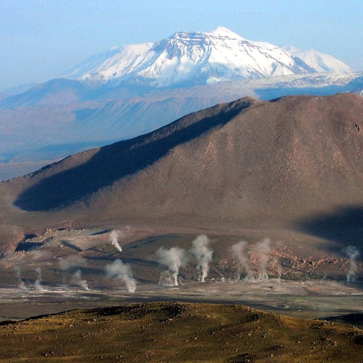
Chile stretches over 2,670 miles (4,300 kilometers) from north to south, crossing some of South America's most varied landscapes. The north features the Atacama Desert with its salt flats, geysers at El Tatio, and astronomical observatories such as Paranal. The coastal city of Valparaíso displays colonial architecture on steep hillsides, while the abandoned nitrate mining towns of Humberstone and Sewell recall the country's industrial past. The Andean region includes active volcanoes like Villarrica and Osorno, and Lauca National Park with Lake Chungará at over 14,760 feet (4,500 meters) elevation.
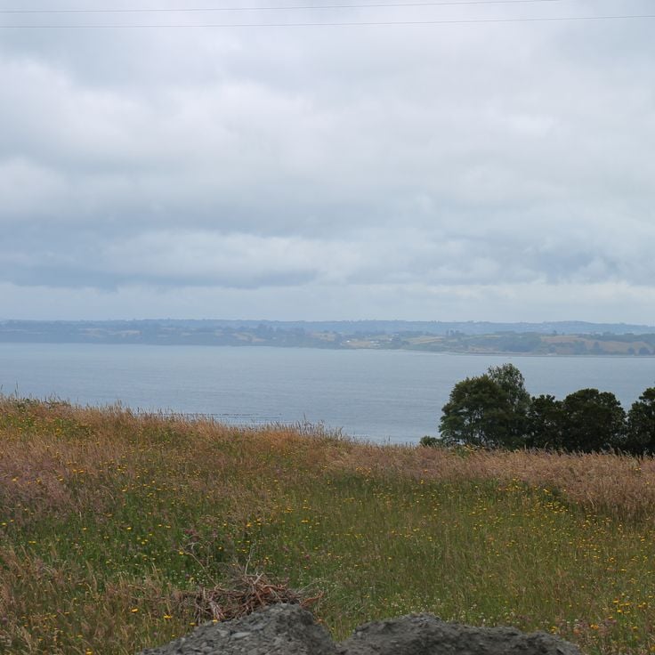
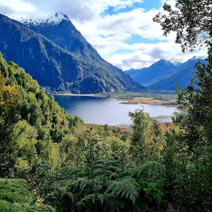
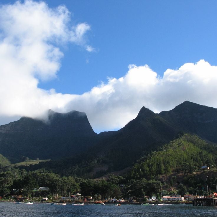
The Lake District and Patagonia offer extensive forests, glaciers, and fjords. Torres del Paine National Park attracts hikers with its granite peaks and Grey Glacier. Lake General Carrera on the Argentine border shows turquoise waters, while Queulat and Bernardo O'Higgins national parks preserve remote wilderness. Chiloé Island is known for its wooden churches and traditional architecture. Further south, Puerto Williams on Navarino Island marks one of the world's southernmost settlements.
Easter Island sits 2,300 miles (3,700 kilometers) west of the coast in the Pacific, displaying over 900 moai statues from its Polynesian past. The Juan Fernández Archipelago, also in the Pacific, offers endemic flora and fauna. In central Chile, ski resorts like Valle Nevado provide winter sports in the Andes, while the Elqui Valley is recognized for pisco production and clear night skies. Santiago, the capital, sits in an Andean valley and serves as a starting point for trips to surrounding national parks such as La Campana.
Chile stretches over 2,670 miles (4,300 kilometers) from north to south, crossing some of South America's most varied landscapes. The north features the Atacama Desert with its salt flats, geysers at El Tatio, and astronomical observatories such as Paranal. The coastal city of Valparaíso displays colonial architecture on steep hillsides, while the abandoned nitrate mining towns of Humberstone and Sewell recall the country's industrial past. The Andean region includes active volcanoes like Villarrica and Osorno, and Lauca National Park with Lake Chungará at over 14,760 feet (4,500 meters) elevation.
The Lake District and Patagonia offer extensive forests, glaciers, and fjords. Torres del Paine National Park attracts hikers with its granite peaks and Grey Glacier. Lake General Carrera on the Argentine border shows turquoise waters, while Queulat and Bernardo O'Higgins national parks preserve remote wilderness. Chiloé Island is known for its wooden churches and traditional architecture. Further south, Puerto Williams on Navarino Island marks one of the world's southernmost settlements.
Easter Island sits 2,300 miles (3,700 kilometers) west of the coast in the Pacific, displaying over 900 moai statues from its Polynesian past. The Juan Fernández Archipelago, also in the Pacific, offers endemic flora and fauna. In central Chile, ski resorts like Valle Nevado provide winter sports in the Andes, while the Elqui Valley is recognized for pisco production and clear night skies. Santiago, the capital, sits in an Andean valley and serves as a starting point for trips to surrounding national parks such as La Campana.
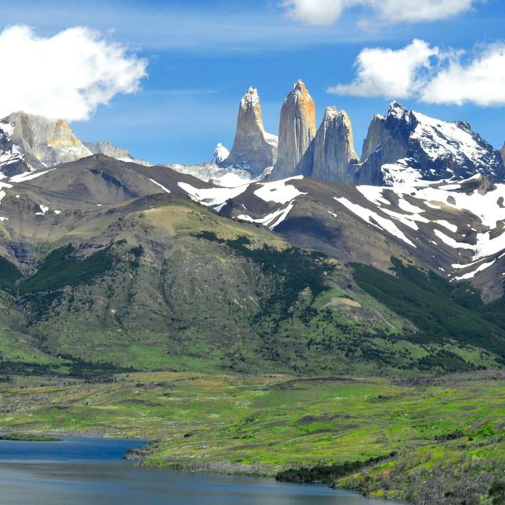
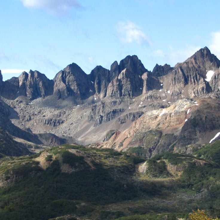
Torres del Paine National Park covers 227,298 hectares (561,500 acres) in the Chilean Andes, displaying vertical granite formations, glaciers and lakes. The protected area provides habitat for guanacos and condors along with other species of the Patagonian ecosystem. The three distinctive granite towers rise over 8,200 feet (2,500 meters) and define the park's landscape. Trails connect different geographic zones from steppes to glaciated mountain ranges.
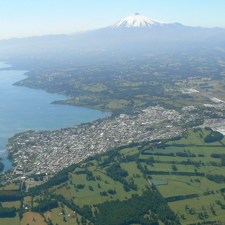
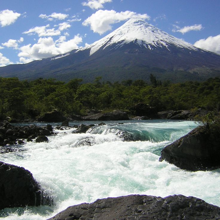
Osorno rises to 8,700 feet (2,652 meters) in the Los Lagos region, its nearly perfect conical form marking the boundary between Lago Llanquihue and Lago Todos los Santos. The volcano's year-round snow-capped summit serves as a landmark for hikers and skiers who use the mountain station at 4,070 feet (1,240 meters). Its last documented eruption occurred in 1835, and it has remained dormant since then, though it remains geologically active.
Lauca National Park sits at 14,800 feet (4,500 meters) elevation and protects a high-altitude landscape of salt lakes, wetlands and volcanoes. The reserve provides habitat for flamingos and vicuñas in one of Chile's highest regions.
The Paranal Observatory is an astronomical center located at 8,645 feet (2,635 meters) in the Atacama Desert. It operates four main telescopes with 27-foot (8.2-meter) diameters used for space observation. The facility belongs to the European Southern Observatory and takes advantage of the region's exceptional atmospheric conditions for scientific research. Visitors can join organized tours to view the telescopes and technical installations.
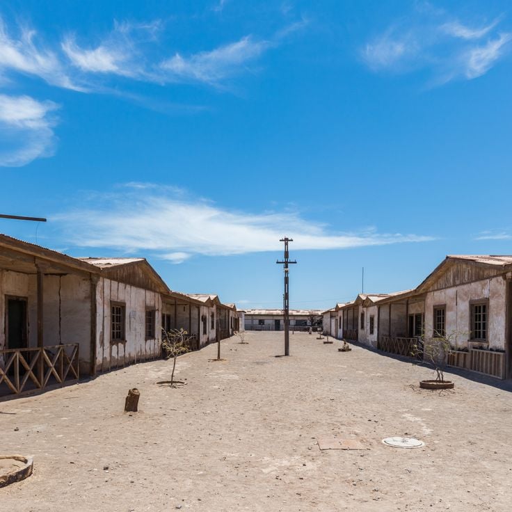
This abandoned 19th-century industrial complex in northern Chile preserves the history of saltpeter mining in the Atacama Desert. The remaining structures include worker housing, a theater, a hospital and processing facilities that show the working and living conditions during the economic boom of the nitrate industry through the 1930s. The site lies in the desert landscape near Iquique and holds UNESCO World Heritage status.
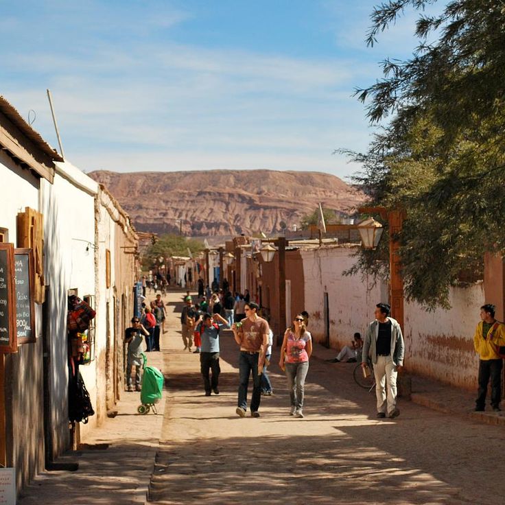
San Pedro de Atacama served as a pre-Hispanic agricultural center in the Atacama Desert. The village preserves a 17th-century colonial church and functions today as a base for exploring the salt flats, geysers and archaeological sites of the region.
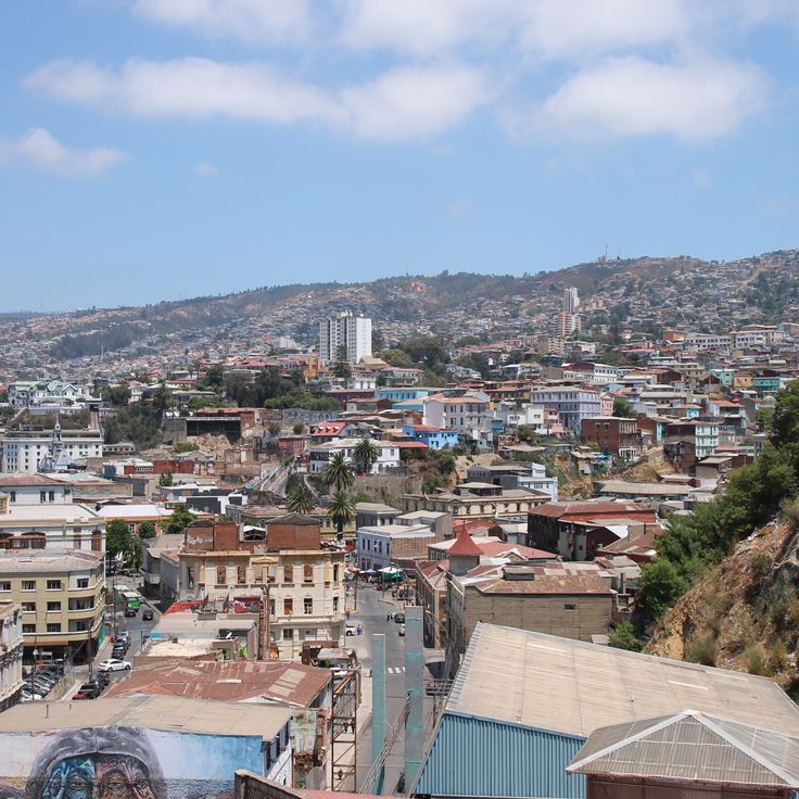
This maritime port was founded in 1536 and became the country's primary commercial harbor. The city spreads across 42 hills, connected by a network of funicular railways that have operated since the late 19th century. Residential areas display dense construction with painted wooden and corrugated metal houses built on steep slopes. The historic quarter received UNESCO World Heritage status in 2003, documenting the development of a major Pacific port city in South America.
The Elqui Valley stretches 56 miles (90 kilometers) between the Andes and the Atacama Desert in the Coquimbo Region. Vineyards along the Elqui River produce grapes for Chilean pisco distillation. The valley ranges from 2,100 to 6,900 feet (650 to 2,100 meters) in elevation and hosts several pisco distilleries, including Capel and Pisco Elqui. The clear night skies attract astronomers to several international observatories in the area.
This national park features a notable geological formation: seven natural basins carved by waterfalls into volcanic rock. The cascades of the Claro River tumble through a narrow gorge and have shaped these pools over thousands of years. Trails wind through southern beech forests and along the waterfalls, though access to certain areas may be restricted depending on weather conditions.
Chiloé Island is among Chile's UNESCO sites with sixteen wooden churches from the 18th century built in traditional Chilote architectural style. These churches combine European mission tradition with local craftsmanship and materials including native larch wood and alerce cypress shingles. The island sits in the southern Región de los Lagos and extends 190 kilometers (118 miles) in length, with fishing villages, temperate rainforests and a Pacific coastline. The Chiloé archipelago comprises more than thirty inhabited islands, with the main island being South America's second largest. The churches stand in communities such as Castro, Achao and Dalcahue, accessible by ferry or via the Pan-American Highway.
This nature reserve extends across 990,000 acres (400,000 hectares) of Valdivian rainforest, protecting centuries-old cypress trees, waterfalls and a network of hiking trails. Parc Pumalín preserves one of the last intact temperate rainforest landscapes in the southern hemisphere and provides access to alerce trees that rank among the oldest living organisms on Earth.
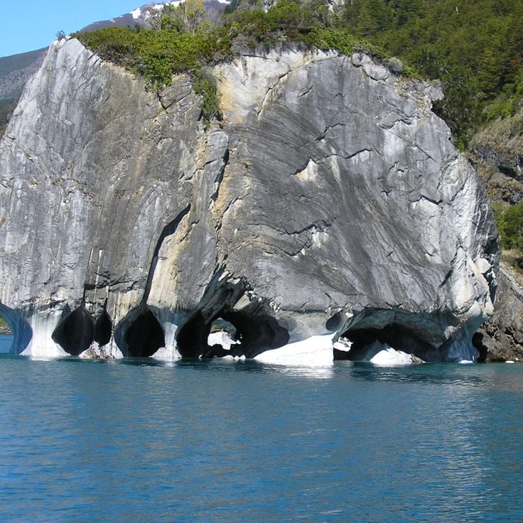
Lago General Carrera is a binational body of water covering 718 square miles (1,850 square kilometers), recognized for its karst formations and marble breccias. The lake stretches across the Chilean-Argentine border and contains geological structures whose walls have been polished by water action over thousands of years. The mineral-rich rock displays hues ranging from white to pink and turquoise, visible at sites such as the Catedrales de Mármol. Water levels fluctuate seasonally, affecting access to the caverns.
Parque Nacional Bernardo O'Higgins covers 13,615 square miles (35,259 km²), ranking among Chile's largest protected areas. The landscape combines deep fjords, branching marine channels, extensive ice fields and peaks of the Andean cordillera. Located in the remote wilderness of Patagonia, the terrain features glaciers that descend to sea level and steep mountain walls rising directly from the water. Access is by boat or aircraft only, with no roads penetrating the park. Wildlife includes sea lions, cormorants and Andean condors. Several glaciers flow into the fjords, creating natural displays of calving ice throughout the year.
Navarino Island extends south of the Beagle Channel and encompasses forested mountain slopes, fjords and valleys. Puerto Williams serves as the administrative center with about 2,000 residents and provides access to trails through subantarctic forests. The mountain ranges in the island's interior rise above 4,000 feet (1,200 meters), while the coastal landscape features sheltered bays and waterways.
This geothermal field in the Atacama Desert sits at 14,170 feet (4,320 meters) and contains over 80 active geysers that shoot water and steam into the air at sunrise. El Tatio ranks among the world's highest geyser fields and demonstrates ongoing volcanic activity through boiling mud pots, fumaroles and hot springs. The site lies 55 miles (90 kilometers) north of San Pedro de Atacama and shows peak activity in early morning hours, when cold air amplifies the steam columns. Visitors need time to adjust to the elevation.
Magdalena Island supports a colony of more than 120,000 Magellanic penguins within the Strait of Magellan. The nature reserve sits about an hour by boat from Punta Arenas and allows visitors to observe these flightless seabirds in their natural habitat during the breeding season from November through February. A marked trail leads from the landing point to the historic lighthouse and permits close encounters with the animals.
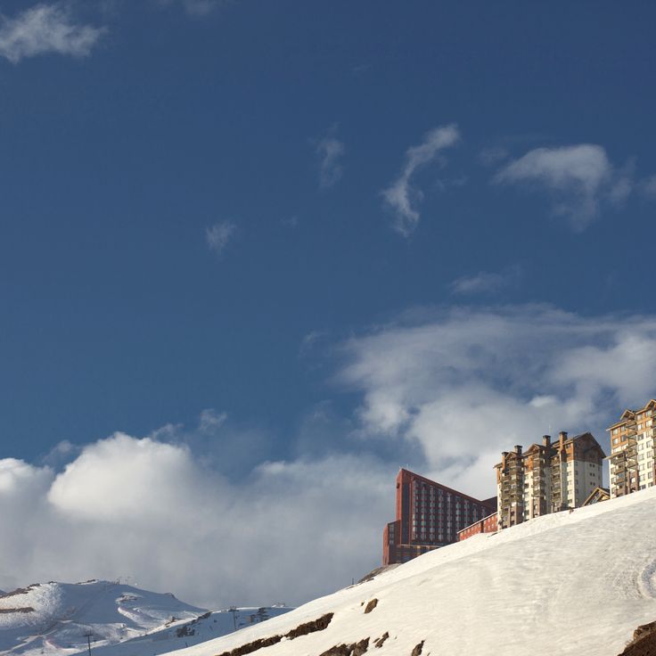
Valle Nevado sits at 10,000 feet (3,025 meters) in the Andes, about 30 miles (50 kilometers) east of Santiago. The resort opened in 1988 and offers 23 miles (37 kilometers) of runs spread across three interconnected mountains. Terrain ranges from beginner slopes to steep descents for advanced skiers. The season runs from June through October, with the best snow conditions typically between July and September. Multiple lifts serve the area, including chairlifts and surface lifts. Infrastructure includes hotels, restaurants and equipment rental facilities at the base. Views from the upper sections take in surrounding Andean peaks and the Maipo Valley below.
Easter Island in the southern Pacific preserves more than 900 moai statues carved between 1100 and 1680 by the Rapa Nui civilization. This Polynesian territory encompasses three extinct volcanoes, ceremonial platforms called ahu, and petroglyph sites that document a complex society that flourished on this 63-square-mile (163-square-kilometer) island before ecological collapse in the 17th century.
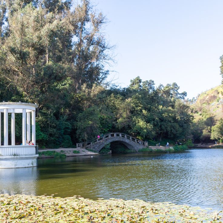
This Chilean capital spreads between the Andes and the Coastal Range, bringing together government institutions, museums and historic plazas. The La Moneda government palace, the Plaza de Armas with its cathedral and central post office, and Cerro San Cristóbal with its funicular station and city views form key reference points. The Museo Nacional de Bellas Artes, the Museo de la Memoria y los Derechos Humanos and the Museo Chileno de Arte Precolombino document art, history and the country's pre-Columbian cultures.
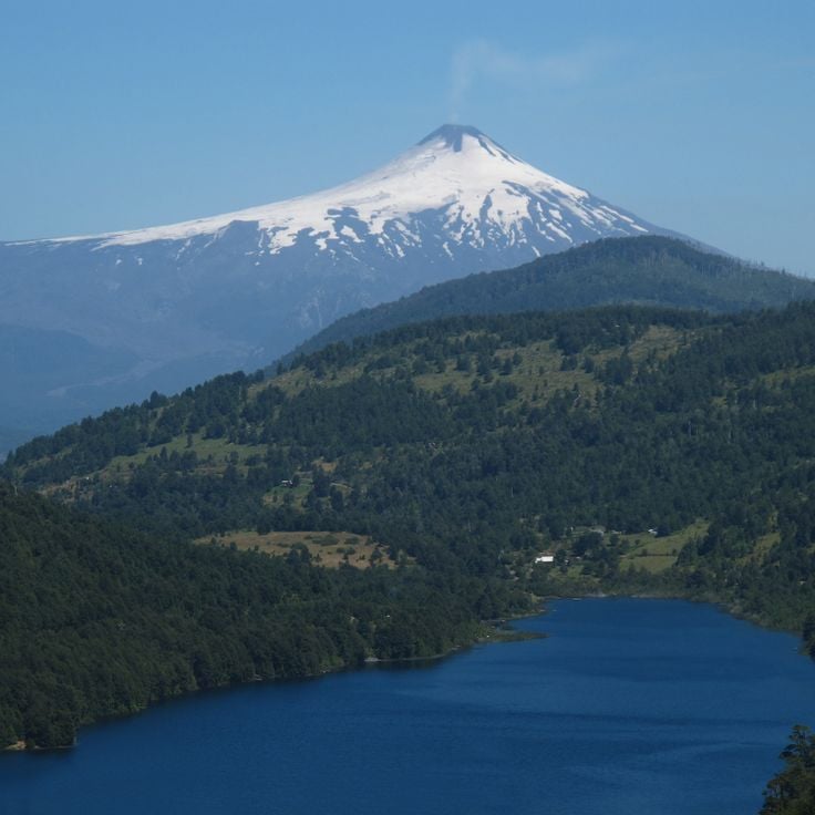
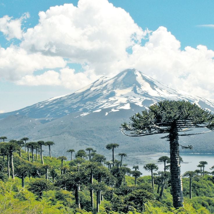
Villarrica rises to 9,380 feet (2,860 meters) above the Lake District and ranks among South America's most active volcanoes. The crater regularly displays glowing magma, while glaciers cover the slopes down to mid-elevations. Lava caves in the lower sections formed during previous eruptions and can be explored with guided tours. The ascent takes approximately six hours and requires crampons and experience on ice.
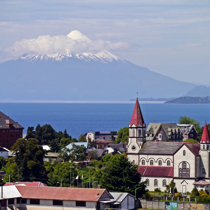
This lakeside town along Llanquihue was founded by German settlers and preserves 19th-century European architecture. Puerto Varas sits at the base of Osorno and Calbuco volcanoes and serves as a gateway to the Chilean Lake District and nearby Vicente Pérez Rosales National Park. Colonial-era wooden houses and churches define the townscape, while the lake offers watersports and boat excursions.
Punta Arenas serves as the main port on the Strait of Magellan and functions as a logistical hub for Antarctic expeditions. The city maintains a maritime terminal, shipyards, and facilities for oil and cargo shipping, forming a crucial node for southern Chilean maritime traffic.
The village of Futaleufú sits in an Andean valley within the Los Lagos Region and is known for its namesake river, one of the world's most demanding whitewater runs. The turquoise river draws rafters and kayakers from around the globe seeking Class IV and V rapids through narrow canyons and boulder fields. The surrounding area offers trails through nothofagus forests and access to remote valleys with glacier views. The village itself serves as a staging point for multi-day river expeditions and has lodging ranging from campgrounds to lodges.
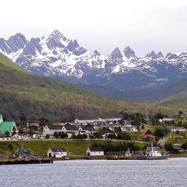
This naval base and Chile's southernmost town sits on the Beagle Channel on Isla Navarino, surrounded by the peaks of the Darwin Range. Puerto Williams serves as a departure point for expeditions to the sub-Antarctic regions and Cape Horn, with access to hiking trails through peat bogs and Nothofagus forests. The settlement houses an ethnographic museum dedicated to the Yaghan people and provides supply facilities for sailors and researchers.
The Valle de la Luna sits within the Salar de Atacama and displays mineral formations shaped by wind and temperature fluctuations. The rocks and salt crystals form natural structures in various shapes and color tones. The area is part of the Los Flamencos National Reserve and extends across several miles in the world's driest desert. Visitors follow marked trails through the geological formations that resemble a lunar landscape.
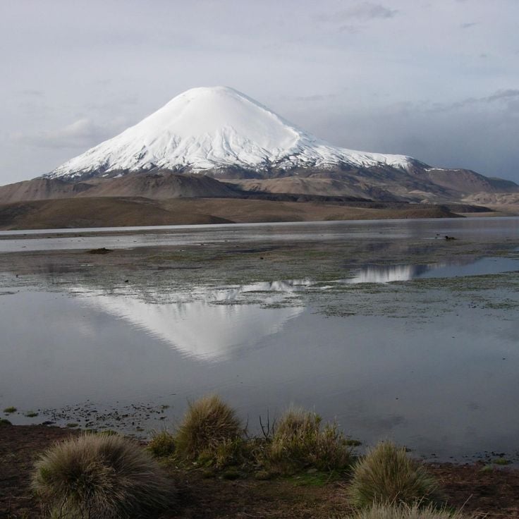
Chungará Lake sits at 14,800 feet (4,500 meters) in the Chilean altiplano, formed by glacial activity. The Parinacota and Pomerape volcanoes frame this high-altitude body of water within Lauca National Park, where the clear surface reflects the surrounding peaks.
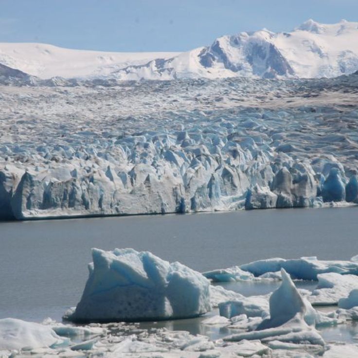
Glacier Grey extends 6 miles across and terminates in a 100-foot-high (30 m) ice wall at the lake of the same name. The Patagonian ice field feeds this glacier tongue, which impresses through its sheer mass and the characteristic blue tones of compressed ice. Boat trips approach the calving edge while hiking trails on the opposite shore provide viewing points. Temperature shifts regularly cause ice chunks to break off and crash into the lake.
Libertador General Bernardo O'Higgins Region, Chile
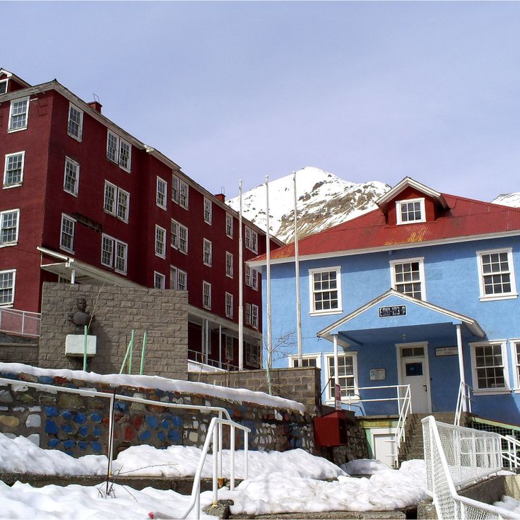
This mining camp was built in 1905 by the Braden Copper Company at 7,200 feet (2,200 meters) to house workers from the El Teniente copper mine. The site grew into a functional town of over 15,000 residents, with residential buildings, schools, hospitals, stores and recreational facilities. The architecture adapted to the steep terrain through terraced structures and covered wooden staircases connecting different levels. Following nationalization of the mine in 1971 and increasing modernization efforts, the last residents left Sewell in 1977. UNESCO recognized the exceptional preservation of this industrial town in 2006.
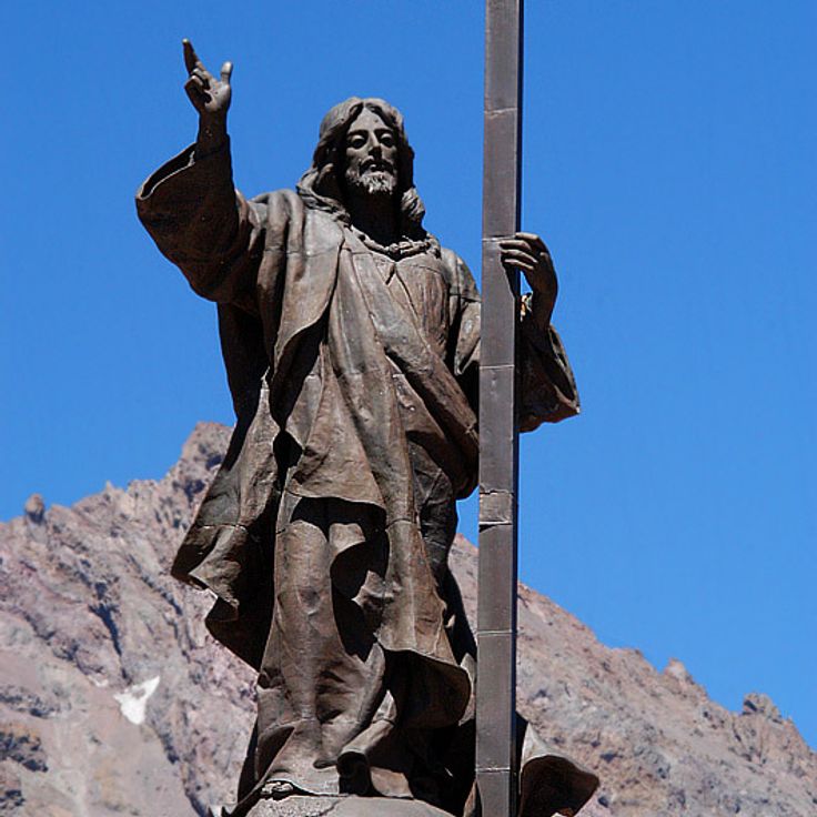
This 13-foot bronze statue at Col de Bermejo has marked the border between Chile and Argentina since 1904, honoring the peaceful resolution of territorial disputes between both countries. The figure stands at 12,644 feet in the Andes and carries an inscription commemorating the peace treaty that ended years of military tensions. Views from here extend across surrounding peaks and valleys on both sides of the border.
This 12,400-acre national park in the Chilean Andes protects araucaria forests, several alpine lakes and an extensive network of trails ranging from 2,360 to 6,560 feet in elevation. The protected araucarias are among the oldest tree species on Earth and define the park's landscape. Visitors can hike marked trails to lagoons including Laguna Verde, Laguna Chico and Laguna Toro, which sit between forested slopes. The park lies approximately 22 miles northeast of Pucón and is most accessible between November and April. Trails pass through dense southern beech and araucaria forests, past waterfalls and viewpoints overlooking the surrounding volcanoes.
Pan de Azúcar National Park protects a coastal strip in the Atacama Desert with sand beaches, rock cliffs and offshore islands that serve as habitat for Humboldt penguins, sea lions and seabirds. The park covers approximately 42 square miles (110 square kilometers) and combines desert landscapes with the cold Pacific, whose nutrient-rich currents support marine life. Visitors can use coastal trails leading to viewpoints above the sea and take boats to Isla Pan de Azúcar, where larger penguin colonies breed.
Conguillío National Park surrounds the active Llaima volcano and protects extensive stands of centuries-old araucaria trees, glacial lakes and solidified lava fields. Trails cross forests of southern beech and offer views of volcanic landscapes. The reserve sits in the Cordillera de los Andes and supports wildlife including Andean condors and Darwin's rheas. Laguna Arcoíris and the Sierra Nevada form distinctive natural features within the park.
La Campana National Park protects one of the last intact populations of the Chilean wine palm, an endemic species that once covered much of central Chile. The reserve spans three sectors with different ecosystems, from Mediterranean dry forests to more humid mountain regions. The main summit reaches 1,880 feet (1,880 meters) in elevation and offers views across the coastal region and the Andes on a demanding day hike. Charles Darwin climbed this mountain during his 1834 Chile expedition and documented the already threatened palm vegetation. The best visiting period falls between April and November, when temperatures are more moderate and vegetation greens after winter rains.
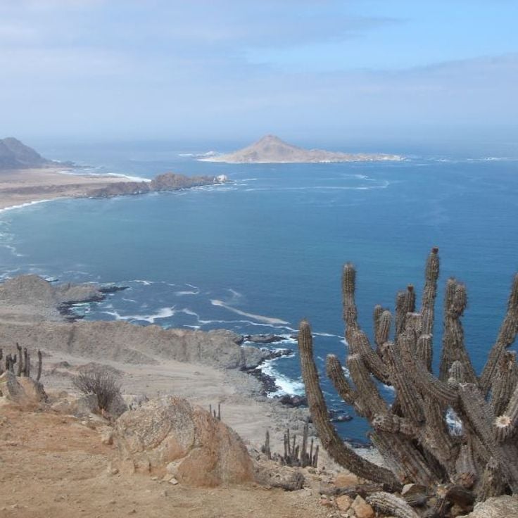
This volcanic archipelago in the Pacific harbors around 900 plant species, with 60 percent found nowhere else on Earth. The three islands support fur seal colonies and hold UNESCO World Heritage status for their biological diversity. Located roughly 415 miles (670 kilometers) off the Chilean coast, the islands formed through volcanic activity. Their isolation has shaped an ecosystem that includes plants and animals adapted to conditions unique to this remote setting.
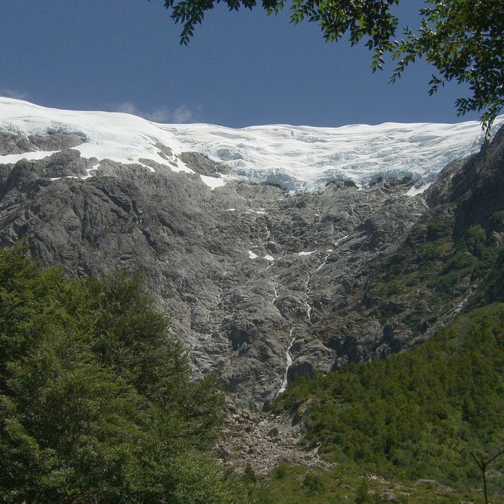
This national park was established in 1926 and sits in the Región de los Lagos. The landscape centers on Osorno Volcano, whose peak rises above Lago Todos los Santos. The Petrohué waterfalls cascade over volcanic rock, while Valdivian rainforests cover the slopes. The lake's green waters reflect the surrounding mountains and provide access to hiking trails and boat connections.
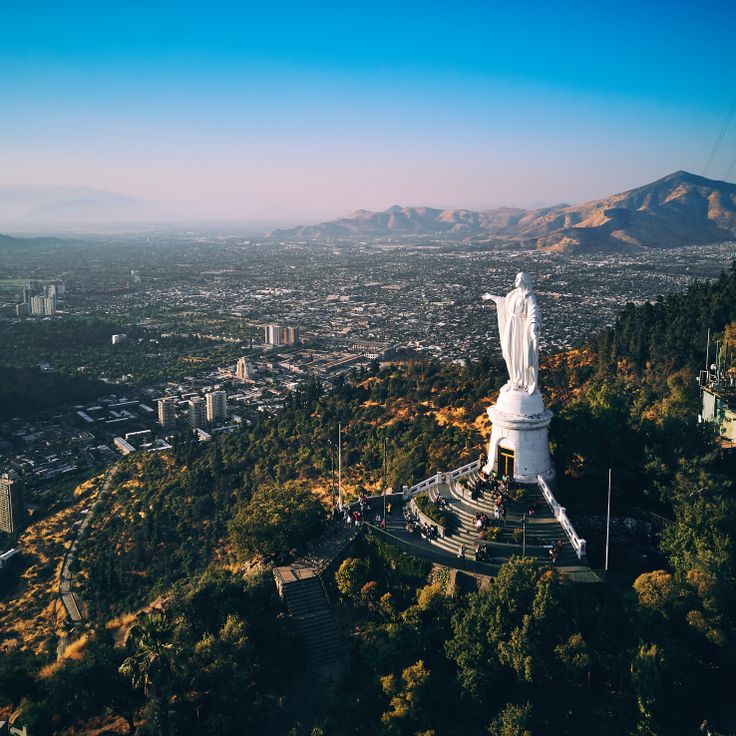
Cerro San Cristóbal rises 2,887 feet (880 meters) above sea level and provides an overlook of Santiago. A funicular railway carries visitors to the summit, where a 72-foot (22-meter) statue of the Virgin Mary stands. The hill forms the centerpiece of Parque Metropolitano, Chile's largest urban park, which includes botanical gardens, hiking trails and recreational areas. Visitors can also reach the summit via a winding road or stairs from the Bellavista neighborhood.
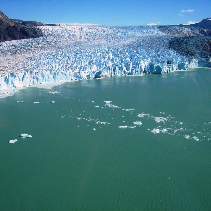
This protected natural area in Región Aysén contains ice fields, glaciers, fjords and marine channels. The San Rafael Glacier descends to sea level, forming one of Patagonia's most accessible glacier fronts. The lagoon regularly receives calving ice blocks that drift through the water. Boat excursions allow visits to the glacier front, while surrounding channels provide access to additional glaciers and fjord landscapes.
This national park in Chilean Patagonia protects the Queulat Hanging Glacier, which drops over a rock face and terminates in a lagoon. The area encompasses temperate rainforests with alerce trees and southern beech, several fjords, and hiking trails that provide access to viewpoints overlooking the glacier. The region receives approximately 100 inches (2,500 millimeters) of precipitation annually and supports pudus, Andean condors, and other Patagonian species.
This 395-acre botanical garden established in 1931 displays collections of native Chilean plants and cacti within a landscaped park north of Viña del Mar, featuring greenhouses, walking trails and themed gardens that represent the country's native and exotic flora.
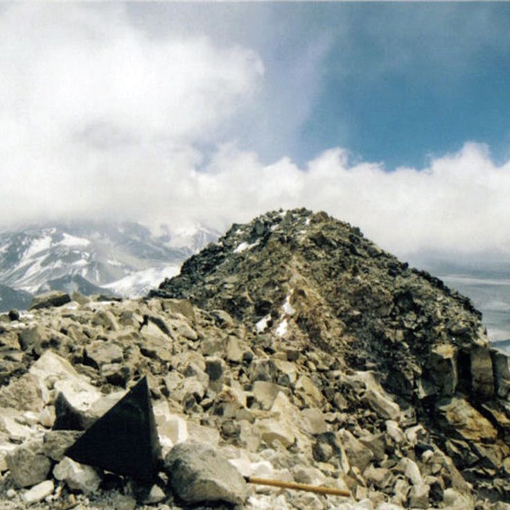
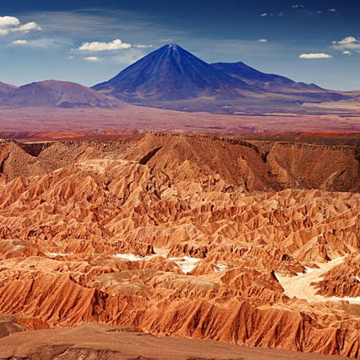
Ojos del Salado rises to 22,615 feet (6,893 meters) above sea level and ranks as the highest active volcano on Earth. This mountain sits on the border between Chile and Argentina in the Atacama Desert, where extreme dryness and thin air make the ascent a demanding undertaking. A small crater lake near its summit is considered one of the highest bodies of water in the world. The route passes through barren landscapes of scree fields and volcanic ash, with several high camps along the way.
Torres del Paine National Park covers 227,298 hectares (561,500 acres) in the Chilean Andes, displaying vertical granite formations, glaciers and lakes. The protected area provides habitat for guanacos and condors along with other species of the Patagonian ecosystem. The three distinctive granite towers rise over 8,200 feet (2,500 meters) and define the park's landscape. Trails connect different geographic zones from steppes to glaciated mountain ranges.
Osorno rises to 8,700 feet (2,652 meters) in the Los Lagos region, its nearly perfect conical form marking the boundary between Lago Llanquihue and Lago Todos los Santos. The volcano's year-round snow-capped summit serves as a landmark for hikers and skiers who use the mountain station at 4,070 feet (1,240 meters). Its last documented eruption occurred in 1835, and it has remained dormant since then, though it remains geologically active.
Lauca National Park sits at 14,800 feet (4,500 meters) elevation and protects a high-altitude landscape of salt lakes, wetlands and volcanoes. The reserve provides habitat for flamingos and vicuñas in one of Chile's highest regions.
The Paranal Observatory is an astronomical center located at 8,645 feet (2,635 meters) in the Atacama Desert. It operates four main telescopes with 27-foot (8.2-meter) diameters used for space observation. The facility belongs to the European Southern Observatory and takes advantage of the region's exceptional atmospheric conditions for scientific research. Visitors can join organized tours to view the telescopes and technical installations.
This abandoned 19th-century industrial complex in northern Chile preserves the history of saltpeter mining in the Atacama Desert. The remaining structures include worker housing, a theater, a hospital and processing facilities that show the working and living conditions during the economic boom of the nitrate industry through the 1930s. The site lies in the desert landscape near Iquique and holds UNESCO World Heritage status.
San Pedro de Atacama served as a pre-Hispanic agricultural center in the Atacama Desert. The village preserves a 17th-century colonial church and functions today as a base for exploring the salt flats, geysers and archaeological sites of the region.
This maritime port was founded in 1536 and became the country's primary commercial harbor. The city spreads across 42 hills, connected by a network of funicular railways that have operated since the late 19th century. Residential areas display dense construction with painted wooden and corrugated metal houses built on steep slopes. The historic quarter received UNESCO World Heritage status in 2003, documenting the development of a major Pacific port city in South America.
The Elqui Valley stretches 56 miles (90 kilometers) between the Andes and the Atacama Desert in the Coquimbo Region. Vineyards along the Elqui River produce grapes for Chilean pisco distillation. The valley ranges from 2,100 to 6,900 feet (650 to 2,100 meters) in elevation and hosts several pisco distilleries, including Capel and Pisco Elqui. The clear night skies attract astronomers to several international observatories in the area.
This national park features a notable geological formation: seven natural basins carved by waterfalls into volcanic rock. The cascades of the Claro River tumble through a narrow gorge and have shaped these pools over thousands of years. Trails wind through southern beech forests and along the waterfalls, though access to certain areas may be restricted depending on weather conditions.
Chiloé Island is among Chile's UNESCO sites with sixteen wooden churches from the 18th century built in traditional Chilote architectural style. These churches combine European mission tradition with local craftsmanship and materials including native larch wood and alerce cypress shingles. The island sits in the southern Región de los Lagos and extends 190 kilometers (118 miles) in length, with fishing villages, temperate rainforests and a Pacific coastline. The Chiloé archipelago comprises more than thirty inhabited islands, with the main island being South America's second largest. The churches stand in communities such as Castro, Achao and Dalcahue, accessible by ferry or via the Pan-American Highway.
This nature reserve extends across 990,000 acres (400,000 hectares) of Valdivian rainforest, protecting centuries-old cypress trees, waterfalls and a network of hiking trails. Parc Pumalín preserves one of the last intact temperate rainforest landscapes in the southern hemisphere and provides access to alerce trees that rank among the oldest living organisms on Earth.
Lago General Carrera is a binational body of water covering 718 square miles (1,850 square kilometers), recognized for its karst formations and marble breccias. The lake stretches across the Chilean-Argentine border and contains geological structures whose walls have been polished by water action over thousands of years. The mineral-rich rock displays hues ranging from white to pink and turquoise, visible at sites such as the Catedrales de Mármol. Water levels fluctuate seasonally, affecting access to the caverns.
Parque Nacional Bernardo O'Higgins covers 13,615 square miles (35,259 km²), ranking among Chile's largest protected areas. The landscape combines deep fjords, branching marine channels, extensive ice fields and peaks of the Andean cordillera. Located in the remote wilderness of Patagonia, the terrain features glaciers that descend to sea level and steep mountain walls rising directly from the water. Access is by boat or aircraft only, with no roads penetrating the park. Wildlife includes sea lions, cormorants and Andean condors. Several glaciers flow into the fjords, creating natural displays of calving ice throughout the year.
Navarino Island extends south of the Beagle Channel and encompasses forested mountain slopes, fjords and valleys. Puerto Williams serves as the administrative center with about 2,000 residents and provides access to trails through subantarctic forests. The mountain ranges in the island's interior rise above 4,000 feet (1,200 meters), while the coastal landscape features sheltered bays and waterways.
This geothermal field in the Atacama Desert sits at 14,170 feet (4,320 meters) and contains over 80 active geysers that shoot water and steam into the air at sunrise. El Tatio ranks among the world's highest geyser fields and demonstrates ongoing volcanic activity through boiling mud pots, fumaroles and hot springs. The site lies 55 miles (90 kilometers) north of San Pedro de Atacama and shows peak activity in early morning hours, when cold air amplifies the steam columns. Visitors need time to adjust to the elevation.
Magdalena Island supports a colony of more than 120,000 Magellanic penguins within the Strait of Magellan. The nature reserve sits about an hour by boat from Punta Arenas and allows visitors to observe these flightless seabirds in their natural habitat during the breeding season from November through February. A marked trail leads from the landing point to the historic lighthouse and permits close encounters with the animals.
Valle Nevado sits at 10,000 feet (3,025 meters) in the Andes, about 30 miles (50 kilometers) east of Santiago. The resort opened in 1988 and offers 23 miles (37 kilometers) of runs spread across three interconnected mountains. Terrain ranges from beginner slopes to steep descents for advanced skiers. The season runs from June through October, with the best snow conditions typically between July and September. Multiple lifts serve the area, including chairlifts and surface lifts. Infrastructure includes hotels, restaurants and equipment rental facilities at the base. Views from the upper sections take in surrounding Andean peaks and the Maipo Valley below.
Easter Island in the southern Pacific preserves more than 900 moai statues carved between 1100 and 1680 by the Rapa Nui civilization. This Polynesian territory encompasses three extinct volcanoes, ceremonial platforms called ahu, and petroglyph sites that document a complex society that flourished on this 63-square-mile (163-square-kilometer) island before ecological collapse in the 17th century.
This Chilean capital spreads between the Andes and the Coastal Range, bringing together government institutions, museums and historic plazas. The La Moneda government palace, the Plaza de Armas with its cathedral and central post office, and Cerro San Cristóbal with its funicular station and city views form key reference points. The Museo Nacional de Bellas Artes, the Museo de la Memoria y los Derechos Humanos and the Museo Chileno de Arte Precolombino document art, history and the country's pre-Columbian cultures.
Villarrica rises to 9,380 feet (2,860 meters) above the Lake District and ranks among South America's most active volcanoes. The crater regularly displays glowing magma, while glaciers cover the slopes down to mid-elevations. Lava caves in the lower sections formed during previous eruptions and can be explored with guided tours. The ascent takes approximately six hours and requires crampons and experience on ice.
This lakeside town along Llanquihue was founded by German settlers and preserves 19th-century European architecture. Puerto Varas sits at the base of Osorno and Calbuco volcanoes and serves as a gateway to the Chilean Lake District and nearby Vicente Pérez Rosales National Park. Colonial-era wooden houses and churches define the townscape, while the lake offers watersports and boat excursions.
Punta Arenas serves as the main port on the Strait of Magellan and functions as a logistical hub for Antarctic expeditions. The city maintains a maritime terminal, shipyards, and facilities for oil and cargo shipping, forming a crucial node for southern Chilean maritime traffic.
The village of Futaleufú sits in an Andean valley within the Los Lagos Region and is known for its namesake river, one of the world's most demanding whitewater runs. The turquoise river draws rafters and kayakers from around the globe seeking Class IV and V rapids through narrow canyons and boulder fields. The surrounding area offers trails through nothofagus forests and access to remote valleys with glacier views. The village itself serves as a staging point for multi-day river expeditions and has lodging ranging from campgrounds to lodges.
This naval base and Chile's southernmost town sits on the Beagle Channel on Isla Navarino, surrounded by the peaks of the Darwin Range. Puerto Williams serves as a departure point for expeditions to the sub-Antarctic regions and Cape Horn, with access to hiking trails through peat bogs and Nothofagus forests. The settlement houses an ethnographic museum dedicated to the Yaghan people and provides supply facilities for sailors and researchers.
The Valle de la Luna sits within the Salar de Atacama and displays mineral formations shaped by wind and temperature fluctuations. The rocks and salt crystals form natural structures in various shapes and color tones. The area is part of the Los Flamencos National Reserve and extends across several miles in the world's driest desert. Visitors follow marked trails through the geological formations that resemble a lunar landscape.
Chungará Lake sits at 14,800 feet (4,500 meters) in the Chilean altiplano, formed by glacial activity. The Parinacota and Pomerape volcanoes frame this high-altitude body of water within Lauca National Park, where the clear surface reflects the surrounding peaks.
Glacier Grey extends 6 miles across and terminates in a 100-foot-high (30 m) ice wall at the lake of the same name. The Patagonian ice field feeds this glacier tongue, which impresses through its sheer mass and the characteristic blue tones of compressed ice. Boat trips approach the calving edge while hiking trails on the opposite shore provide viewing points. Temperature shifts regularly cause ice chunks to break off and crash into the lake.
Libertador General Bernardo O'Higgins Region, Chile
This mining camp was built in 1905 by the Braden Copper Company at 7,200 feet (2,200 meters) to house workers from the El Teniente copper mine. The site grew into a functional town of over 15,000 residents, with residential buildings, schools, hospitals, stores and recreational facilities. The architecture adapted to the steep terrain through terraced structures and covered wooden staircases connecting different levels. Following nationalization of the mine in 1971 and increasing modernization efforts, the last residents left Sewell in 1977. UNESCO recognized the exceptional preservation of this industrial town in 2006.
This 13-foot bronze statue at Col de Bermejo has marked the border between Chile and Argentina since 1904, honoring the peaceful resolution of territorial disputes between both countries. The figure stands at 12,644 feet in the Andes and carries an inscription commemorating the peace treaty that ended years of military tensions. Views from here extend across surrounding peaks and valleys on both sides of the border.
This 12,400-acre national park in the Chilean Andes protects araucaria forests, several alpine lakes and an extensive network of trails ranging from 2,360 to 6,560 feet in elevation. The protected araucarias are among the oldest tree species on Earth and define the park's landscape. Visitors can hike marked trails to lagoons including Laguna Verde, Laguna Chico and Laguna Toro, which sit between forested slopes. The park lies approximately 22 miles northeast of Pucón and is most accessible between November and April. Trails pass through dense southern beech and araucaria forests, past waterfalls and viewpoints overlooking the surrounding volcanoes.
Pan de Azúcar National Park protects a coastal strip in the Atacama Desert with sand beaches, rock cliffs and offshore islands that serve as habitat for Humboldt penguins, sea lions and seabirds. The park covers approximately 42 square miles (110 square kilometers) and combines desert landscapes with the cold Pacific, whose nutrient-rich currents support marine life. Visitors can use coastal trails leading to viewpoints above the sea and take boats to Isla Pan de Azúcar, where larger penguin colonies breed.
Conguillío National Park surrounds the active Llaima volcano and protects extensive stands of centuries-old araucaria trees, glacial lakes and solidified lava fields. Trails cross forests of southern beech and offer views of volcanic landscapes. The reserve sits in the Cordillera de los Andes and supports wildlife including Andean condors and Darwin's rheas. Laguna Arcoíris and the Sierra Nevada form distinctive natural features within the park.
La Campana National Park protects one of the last intact populations of the Chilean wine palm, an endemic species that once covered much of central Chile. The reserve spans three sectors with different ecosystems, from Mediterranean dry forests to more humid mountain regions. The main summit reaches 1,880 feet (1,880 meters) in elevation and offers views across the coastal region and the Andes on a demanding day hike. Charles Darwin climbed this mountain during his 1834 Chile expedition and documented the already threatened palm vegetation. The best visiting period falls between April and November, when temperatures are more moderate and vegetation greens after winter rains.
This volcanic archipelago in the Pacific harbors around 900 plant species, with 60 percent found nowhere else on Earth. The three islands support fur seal colonies and hold UNESCO World Heritage status for their biological diversity. Located roughly 415 miles (670 kilometers) off the Chilean coast, the islands formed through volcanic activity. Their isolation has shaped an ecosystem that includes plants and animals adapted to conditions unique to this remote setting.
This national park was established in 1926 and sits in the Región de los Lagos. The landscape centers on Osorno Volcano, whose peak rises above Lago Todos los Santos. The Petrohué waterfalls cascade over volcanic rock, while Valdivian rainforests cover the slopes. The lake's green waters reflect the surrounding mountains and provide access to hiking trails and boat connections.
Cerro San Cristóbal rises 2,887 feet (880 meters) above sea level and provides an overlook of Santiago. A funicular railway carries visitors to the summit, where a 72-foot (22-meter) statue of the Virgin Mary stands. The hill forms the centerpiece of Parque Metropolitano, Chile's largest urban park, which includes botanical gardens, hiking trails and recreational areas. Visitors can also reach the summit via a winding road or stairs from the Bellavista neighborhood.
This protected natural area in Región Aysén contains ice fields, glaciers, fjords and marine channels. The San Rafael Glacier descends to sea level, forming one of Patagonia's most accessible glacier fronts. The lagoon regularly receives calving ice blocks that drift through the water. Boat excursions allow visits to the glacier front, while surrounding channels provide access to additional glaciers and fjord landscapes.
This national park in Chilean Patagonia protects the Queulat Hanging Glacier, which drops over a rock face and terminates in a lagoon. The area encompasses temperate rainforests with alerce trees and southern beech, several fjords, and hiking trails that provide access to viewpoints overlooking the glacier. The region receives approximately 100 inches (2,500 millimeters) of precipitation annually and supports pudus, Andean condors, and other Patagonian species.
This 395-acre botanical garden established in 1931 displays collections of native Chilean plants and cacti within a landscaped park north of Viña del Mar, featuring greenhouses, walking trails and themed gardens that represent the country's native and exotic flora.
Ojos del Salado rises to 22,615 feet (6,893 meters) above sea level and ranks as the highest active volcano on Earth. This mountain sits on the border between Chile and Argentina in the Atacama Desert, where extreme dryness and thin air make the ascent a demanding undertaking. A small crater lake near its summit is considered one of the highest bodies of water in the world. The route passes through barren landscapes of scree fields and volcanic ash, with several high camps along the way.