See the monuments around you in AROpen chests in the app
Around Us is built for your phone — point your camera at the streets and discover the monuments and places around you in augmented reality.Around Us is built for your phone — chests unlock when you walk, explore and capture nearby places.
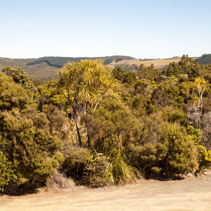
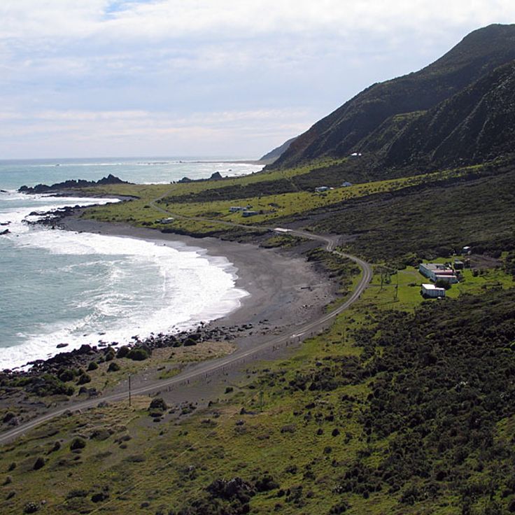
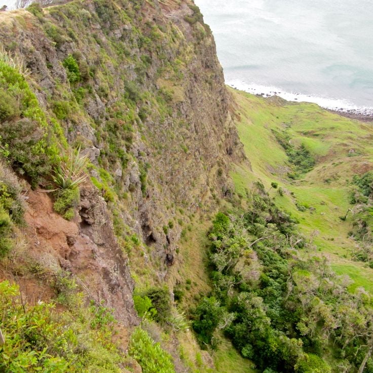
New Zealand shows its wild and beautiful views to those who seek them. From snow-capped mountains to deep fjords.
New Zealand offers many photo subjects: its landscape includes hot springs in Rotorua, glaciers like Franz Josef and Tasman, and fjords in Fiordland. Mount Cook stands above the mountains, while the Coromandel Peninsula has beaches such as Hot Water Beach and Cathedral Cove. The Tongariro Alpine Crossing goes through volcanic land, and Mount Taranaki rises over Taranaki. Coastal shapes like the Moeraki Boulders, Split Apple Rock and Nugget Point show different rocks. Natural waterfalls like Purakaunui Falls and Whangarei Falls are in native forests.
Cultural sites add to the landscape. Hobbiton Movie Set near Matamata is where the Lord of the Rings movies were filmed. Larnach Castle near Dunedin is colonial style. Te Puia and Wai-O-Tapu show geothermal activity with geysers and colored pools. Waitomo Caves have glowworm caves. Lake Tekapo has clear night skies for star watching. Viewpoints like Roy's Peak near Wanaka and Queenstown Hill look over lakes. Remote areas like Cape Reinga at the north end and Cape Palliser in Wairarapa show different coastlines. The Forgotten World Highway crosses mountains on the North Island.
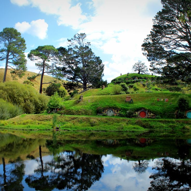
This permanent film location covers 5.7 hectares (14 acres) of farmland in the Matamata-Piako District and was built for the Hobbit and Lord of the Rings films. Hobbiton Movie Set contains 44 hobbit holes with different sizes of round doors set into hillsides. The site features detailed gardens, a working vegetable garden, the Green Dragon Inn and the Mill pond. The hobbit holes range from large versions for Gandalf scenes to smaller ones that represent the size differences between characters. Visitors follow guided tours through the Shire set, which remained after filming as a permanent attraction.
This freshwater lake in the New Zealand Alps sits at an elevation of 2,300 feet (700 meters) and displays its turquoise color from finely ground glacial rock suspended in the mineral-rich water. Lake Tekapo draws its waters from surrounding glaciers and ranks among New Zealand's most photographed locations. The setting provides clear views of the Southern Alps and lies within one of the world's darkest sky reserves, making the lake particularly suitable for night photography. The lake stretches roughly 17 miles (27 kilometers) through the Mackenzie District and attracts photographers for its color contrasts between water, mountains and sky.
This fjord stretches 16 kilometers inland, with vertical rocky walls that drop up to 265 meters into the water. Milford Sound has steady waterfalls that flow down from the surrounding peaks, including Mitre Peak, which stands 1692 meters tall. Regular rain creates temporary waterfalls along the cliffs, while the dark water is tinted by the tannins from the nearby rainforest. Boat and kayak trips follow the sides of the fjord, where seals rest on rocks and dolphins sometimes appear.
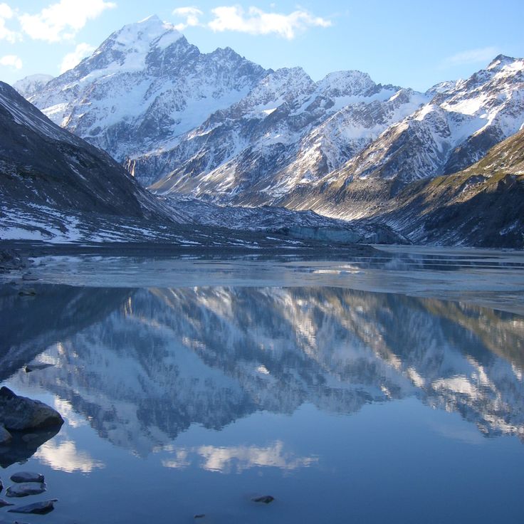
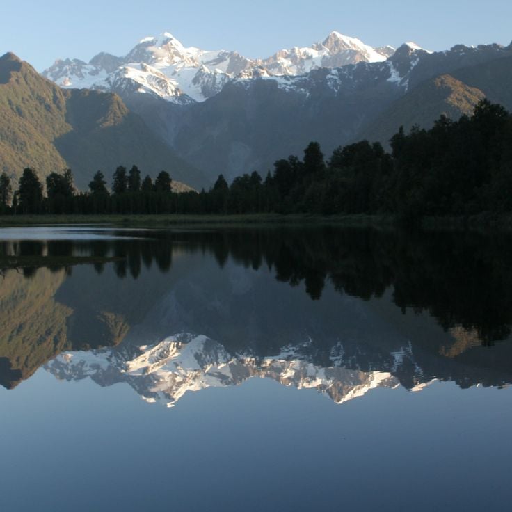
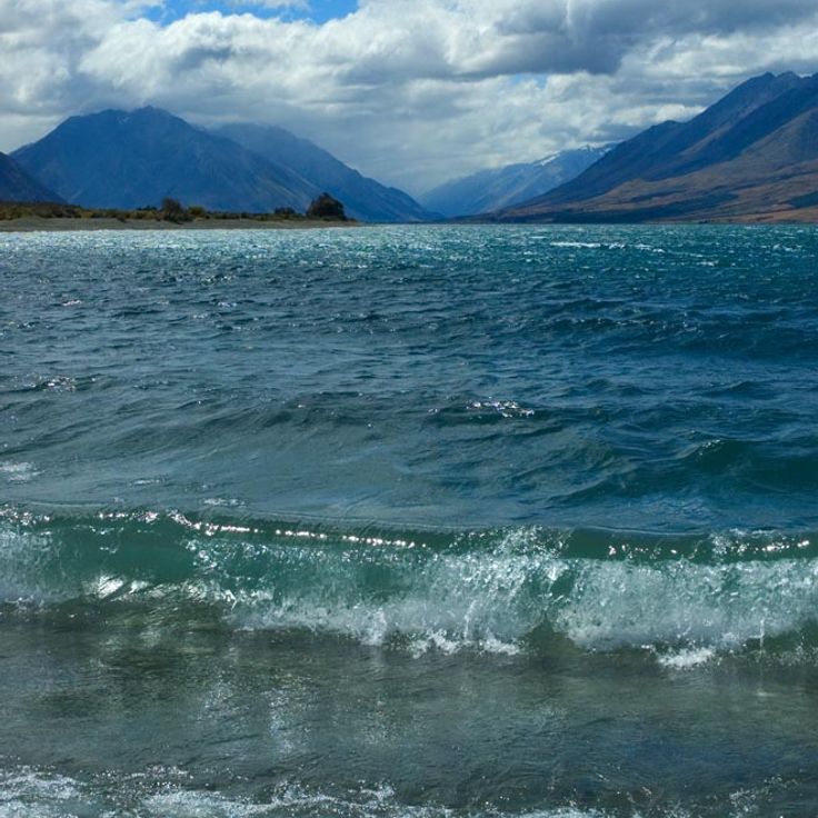
Mount Cook National Park covers 70696 hectares in the Canterbury region and contains 23 peaks above 3000 meters as well as 72 named glaciers. The park includes Aoraki/Mount Cook, the tallest mountain in New Zealand at 3724 meters, and shows alpine terrain from glacier valleys to mountain lakes. The land here is among the most photographed in New Zealand, with mountain formations stretching through the Southern Alps and glaciers like the Tasman Glacier, the longest in the country. Trails lead to viewpoints over the Hooker Valley and places where snow, rocks, and alpine plants can be seen together.
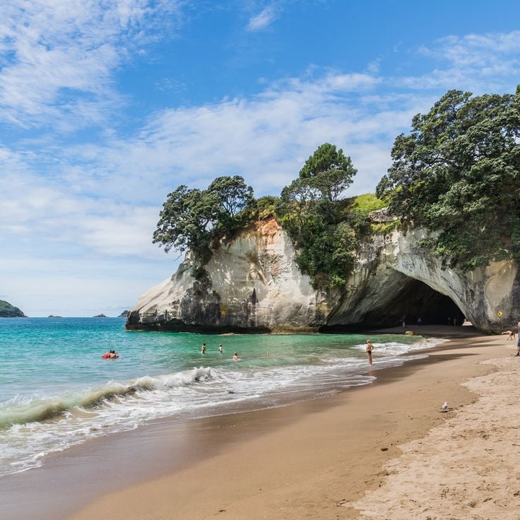
This natural cove on the Coromandel Peninsula features an 82-foot (25-meter) limestone arch rising over white sand. Cathedral Cove is accessible only by foot, kayak or boat. The turquoise water and pale rock formations attract photographers documenting New Zealand's coastal landscape. The beach is part of a marine reserve. A walking track from the Hahei car park leads to the beach in roughly 30 minutes, passing through native bush with views across the Pacific.
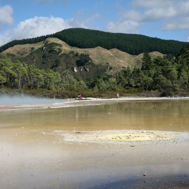
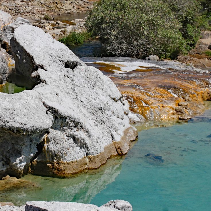
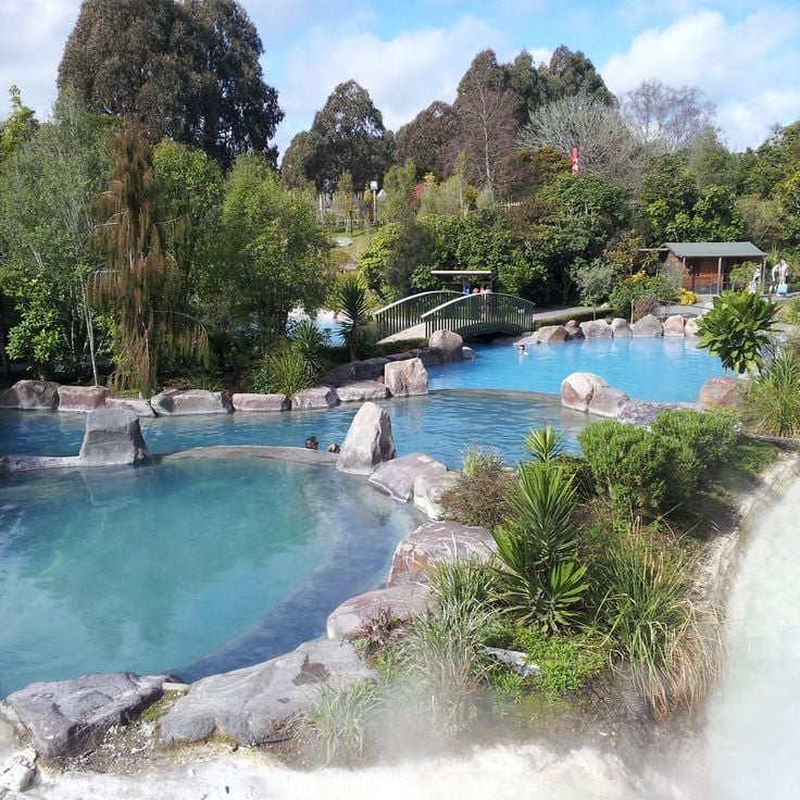
This geothermal reserve near Rotorua presents a landscape of mineral pools created by volcanic activity. The pools contain various chemical compounds that produce colors ranging from orange to green. Visitors follow walking tracks along steaming craters and past silica terraces. The Champagne Pool, named for rising gas bubbles, reaches temperatures around 165°F (75°C). The Lady Knox Geyser erupts daily at a set time, reaching heights up to 65 feet (20 meters). Wai-O-Tapu Thermal Wonderland makes accessible the geothermal activity that defines this region of New Zealand.
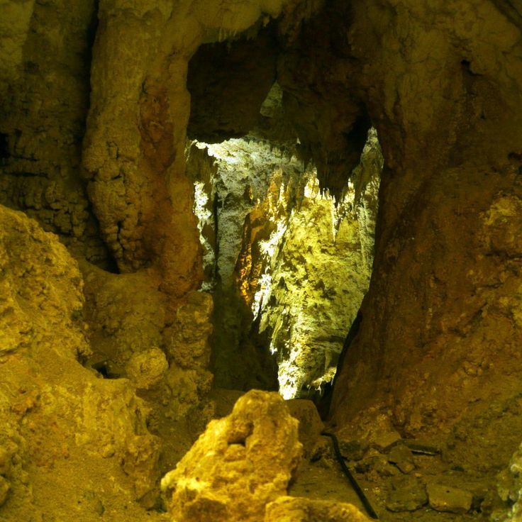
The Waitomo Caves are an underground cave system in Waitomo District where thousands of New Zealand glowworm larvae illuminate the ceilings. These caves rank among the most photogenic locations in New Zealand, offering visitors the opportunity to photograph the luminous larvae of Arachnocampa luminosa during boat rides through the dark chambers. The bioluminescent larvae create a natural light display resembling a starlit sky. The cave system extends across multiple levels and includes both dry and flooded sections formed by underground rivers.
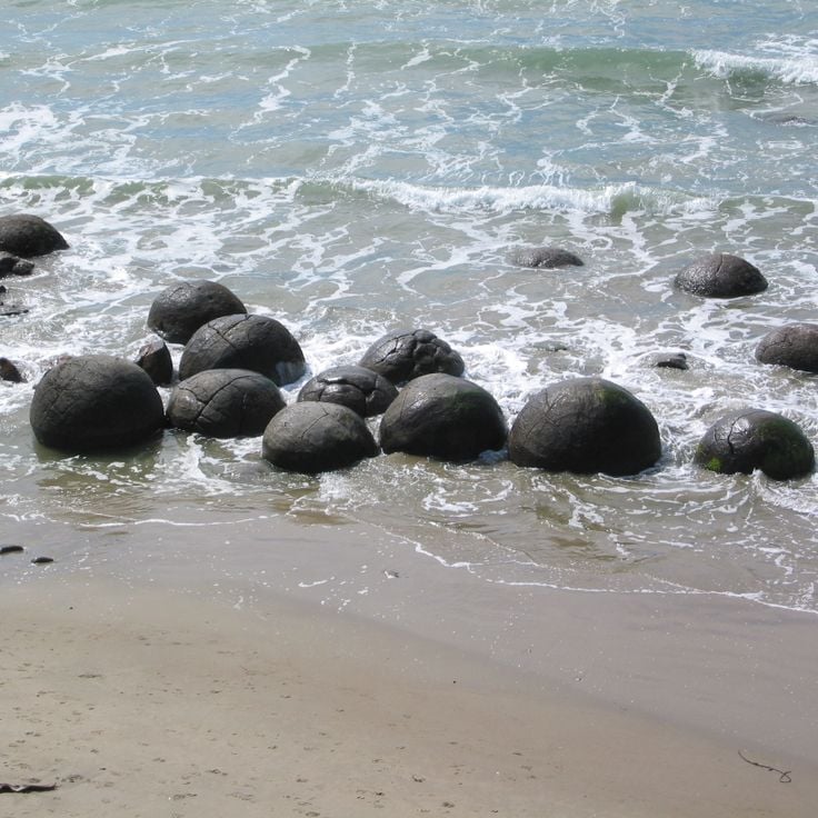
These distinctive spherical boulders of calcium carbonate lie scattered across Koekohe Beach and formed through sedimentation and erosion over approximately 60 million years. The Moeraki Boulders reach diameters up to 7 feet (2 meters) and weigh several tons. Geologists have determined that the boulders grew through crystallization of minerals around an organic core while the surrounding mudstone gradually eroded away by the sea. Maori associate the formation with legends of a sunken canoe. Visitors reach the boulders via a short path from the car park on State Highway 1, approximately 25 miles (40 kilometers) south of Oamaru.
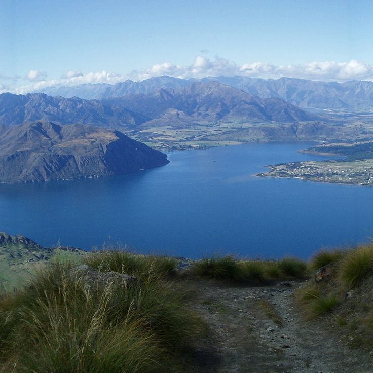
This 1578-meter high summit offers a wide view of Lake Wānaka, the nearby peaks of the Southern Alps, and the valley of Matukituki in the Otago region. The steep trail climbs through pastures and rocky terrain for about 16 kilometers round trip, with the final sections being especially exposed. From the top, you can see as far as Mount Aspiring to the west, the deep blue lake below, and the mountain ranges stretching to the horizon. Roy's Peak has become one of the most photographed spots in New Zealand, mainly because of the view of the lake and mountains from a high position, especially clear in good weather.
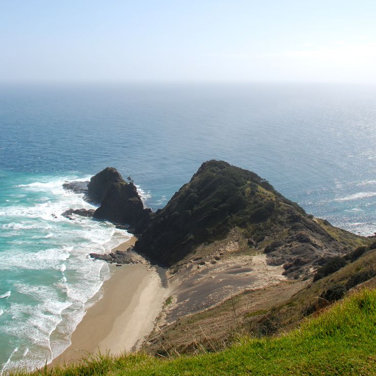
This northernmost point of mainland New Zealand marks where the Pacific Ocean and Tasman Sea meet in often turbulent waters. An old pohutukawa tree stands at this cape, which holds significance in Maori culture as the place where spirits depart for their ancestral homeland. Cape Reinga offers views across the converging seas and rocky coastline. A lighthouse built in 1941 marks the exposed position at the tip of the Aupouri Peninsula, making it a photographic location that captures both natural geography and cultural meaning.
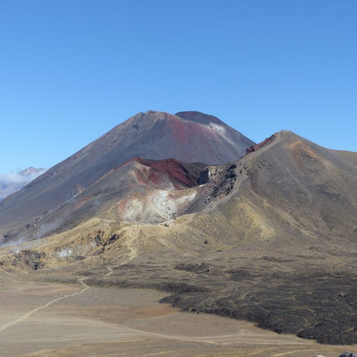
This trail extends 19 kilometers (12 miles) across Tongariro National Park, connecting active volcanic cones with crater lakes and alpine vegetation. The route crosses lava tongues and ash plateaus between Mount Ngauruhoe and Mount Tongariro, where turquoise lakes have formed in volcanic craters. The path climbs to approximately 6,200 feet (1,900 meters) and provides views across the central volcanic plateau of the North Island. Hikers traverse different geological zones that document the volcanic history of the region.
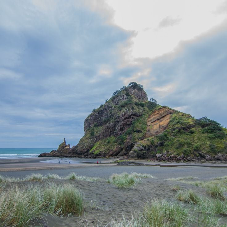
Piha Beach extends along the coast with black volcanic sand and ranks among the most recognized surf beaches near Auckland. The waves reach substantial heights and draw surfers from across New Zealand and beyond. Lion Rock, a prominent formation, rises approximately 330 feet (100 m) from the water and serves as a landmark. The beach sits 28 miles (45 km) west of the city and connects via a winding road through dense rainforest. The powerful surf and unpredictable currents require caution when swimming.
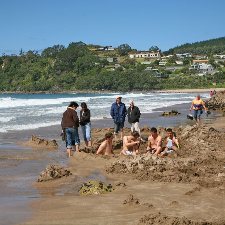
This beach on the Coromandel Peninsula offers an unusual geological phenomenon where hot springs emerge through the sand, allowing visitors to dig their own warm pools at low tide. Hot Water Beach represents one of New Zealand's photogenic locations where geothermal activity meets coastal landscape. The best time to visit falls within two hours either side of low tide, when the sand is accessible and thermal water reaches the surface.
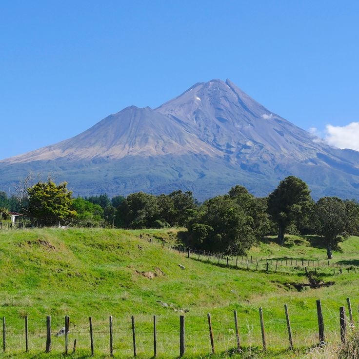
This volcano stands at 2518 meters above sea level and is among the most symmetrical volcanic cones in the world. Mount Taranaki offers several hiking trails, from climbs to the summit to day walks through the park’s vegetation areas. The geological formation is about 120000 years old and last erupted in the 18th century. Photographers find subjects ranging from mountain landscapes to dense tropical forests covering the lower parts of the mountain.
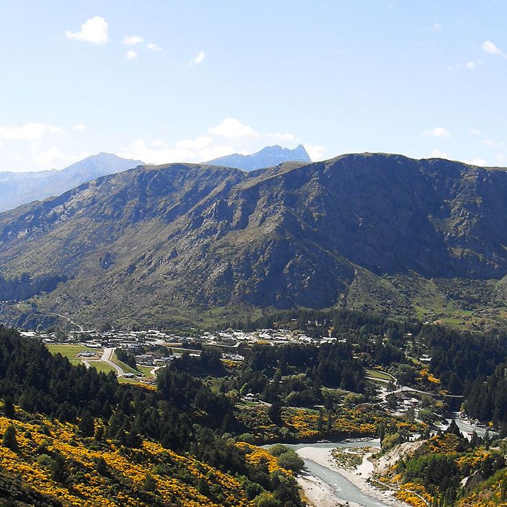
This viewpoint at 1,640 feet (500 meters) elevation offers hiking trails through the mountains above Queenstown. From the summit, visitors see the town, Lake Wakatipu and the Remarkables range. The ascent takes roughly two hours and passes through forest sections with native trees. The viewing platform suits photographers capturing the Wakatipu Basin and surrounding peaks. The track begins at the edge of town and climbs steadily, with several rest points providing opportunities to observe the changing perspective over the lake and mountain terrain.
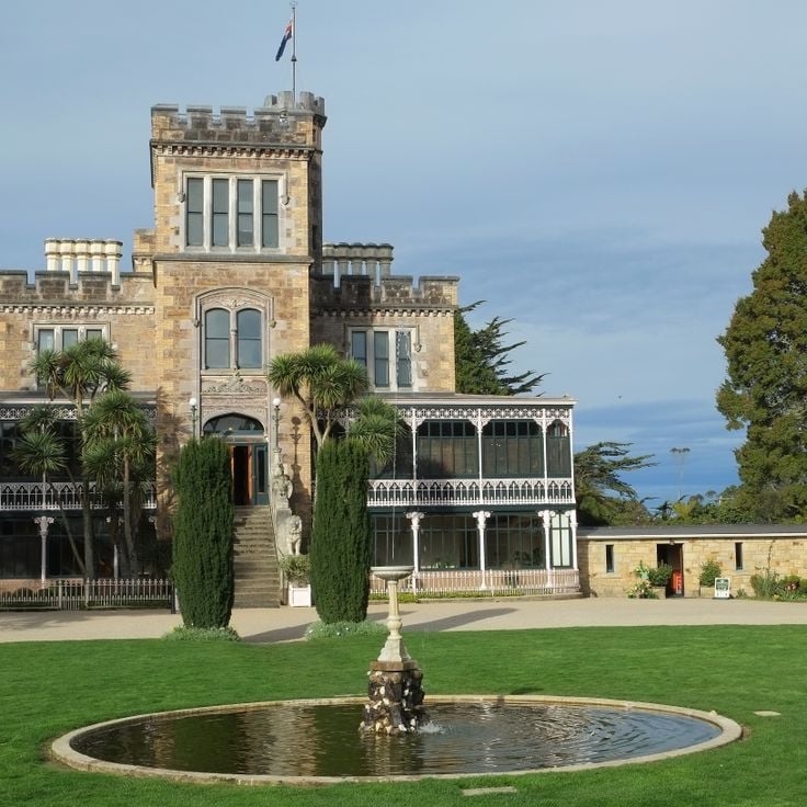
This castle, built in 1871 for banker William Larnach, combines Scottish architectural elements with New Zealand craftsmanship on the Otago Peninsula. The interior features period furnishings from the Victorian era, including Italian marble work and carved wood paneling sourced from native timbers. The gardens include formal layouts, a rockery, and themed sections restored since the 1990s. Visitors can walk through the various rooms furnished with Larnach family items and view the coastline and Dunedin harbor. The estate documents the history of 19th-century New Zealand upper-class residences and represents the photographic diversity that New Zealand offers between historic structures and natural landscapes.
This geothermal park in Rotorua anchors the collection of photogenic locations across New Zealand through its complex of over 500 thermal springs, mud pools and the Pohutu Geyser. The valley demonstrates ongoing volcanic activity with steam clouds, boiling water and mineral deposits. The Pohutu Geyser reaches heights of up to 100 feet (30 meters) and erupts multiple times daily. Visitors also encounter a Māori cultural center featuring carving workshops and traditional meeting houses. The thermal fields produce characteristic colors ranging from white to yellow to orange through different mineral deposits.
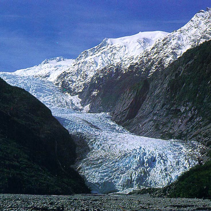
This glacier descends from the Southern Alps through temperate rainforest to an elevation of 980 feet (300 meters) above sea level. Franz Josef Glacier ranks among the most photographed sites on New Zealand's South Island, offering visitors access to ice formations that extend into densely vegetated valleys. Guided walks traverse the glacier surface, while helicopter tours provide views of the ice flows and surrounding peaks. The area demonstrates the interaction between glacial and subtropical climate zones within a compact geographic area.
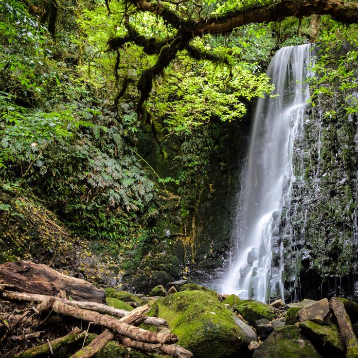
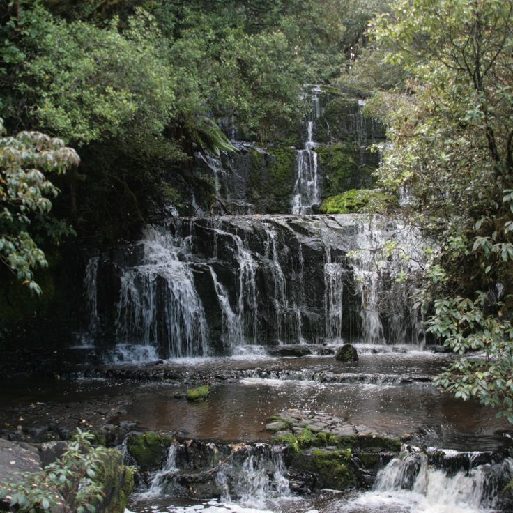
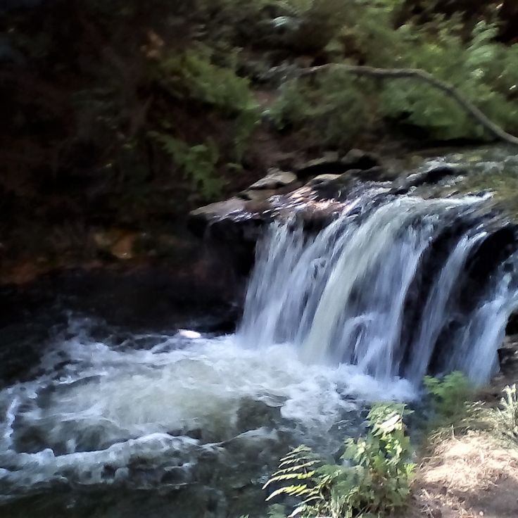
This waterfall descends in three distinct tiers across a combined drop of 65 feet (20 meters) through native podocarp forest. Water flows over broad rock faces surrounded by dense ferns and tree canopy. The falls lie within Catlins Forest Park and rank among the most photographed natural attractions in New Zealand. A short walk of approximately 10 minutes leads from the parking area to the viewing platform, which provides clear views of all three cascades. The site works particularly well for photography during early morning hours or under overcast conditions when light distributes evenly across the scene.
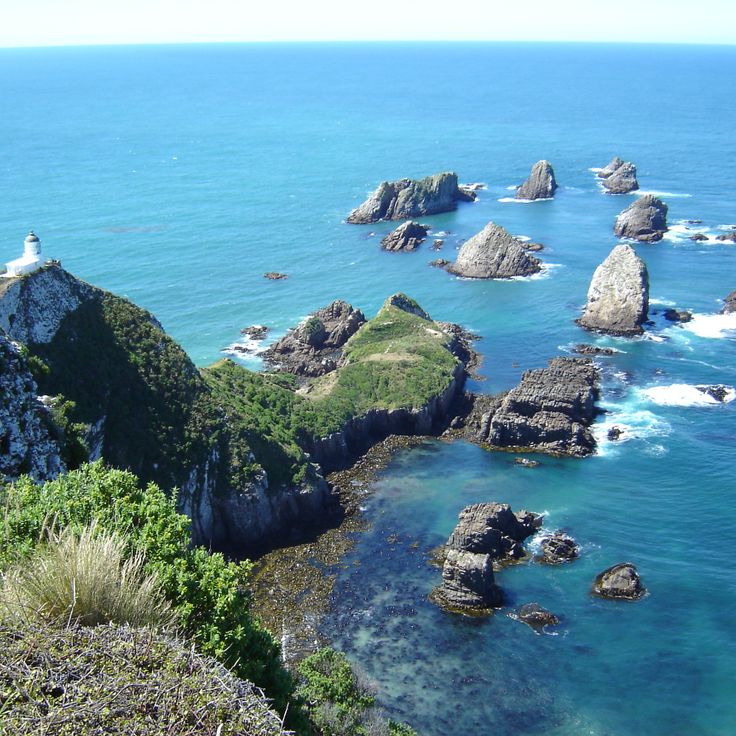
This 1870 lighthouse stands on a rocky headland along the South Island's southeastern coast and provides photo opportunities with offshore rock formations that resemble gold nuggets. Nugget Point ranks among New Zealand's accessible coastal locations where visitors observe sea lions, fur seals and yellow-eyed penguins. The platform at the lighthouse enables wide-angle shots of the rugged coastline and South Pacific. A walking track of approximately 10 minutes connects the car park to the lighthouse. The exposed position creates changing light conditions for landscape photography throughout the day and at sunset.
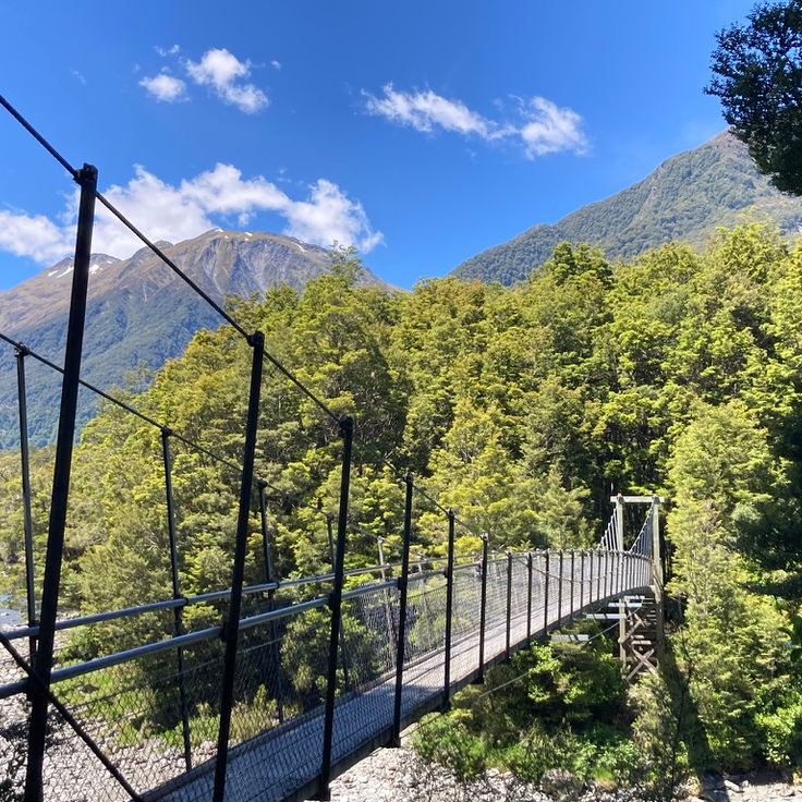
These suspension bridges crossing the turquoise Makarora River provide views of the clear pools in Mount Aspiring National Park. A forest trail of about 0.9 miles (1.5 kilometers) through beech woodland leads from the roadside to the pools. The intense coloration results from suspended glacial particles in the water. Photographers find good lighting conditions here particularly in the morning when the sun reaches the water surface. The track is generally well maintained, though it can become slippery after rain. The pools rank among the most accessible photographic subjects along State Highway 6 between Wanaka and Haast.
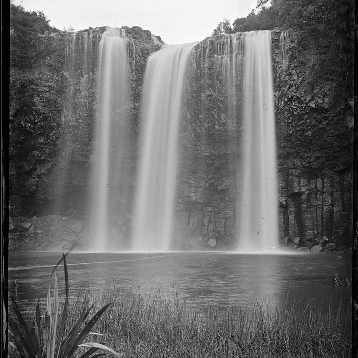
Whangarei Falls is a 85-foot (26-meter) waterfall over basalt columns in Northland that provides multiple viewpoints for photographers. A loop track leads to three platforms at the upper and lower sections of the falls. Water drops over volcanic rock formations into a pool below, creating different perspectives depending on position. Surrounding vegetation of native ferns and trees frames shots from each platform. The platforms allow compositions from various angles and elevations. This waterfall is among the photographic locations across New Zealand that range from mountains and beaches to urban centers.
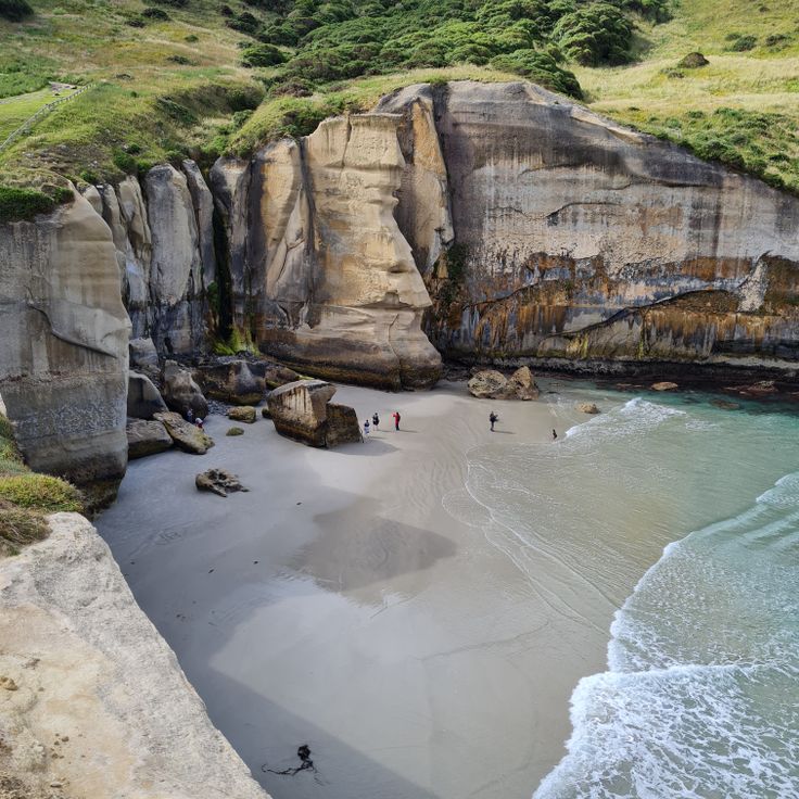
Tunnel Beach lies south of Dunedin and takes its name from a hand carved tunnel cut through rock in the 1870s to provide access to the shore. The limestone cliffs along the coastline contain visible fossils and display geological formations shaped over millions of years. The beach itself sits in a sheltered cove surrounded by steep rock walls. Walking tracks run along the clifftops and provide views across the South Pacific. The area attracts photographers for its unusual rock formations and the tunnel entrance, making it one of the most photogenic locations across New Zealand.
This lake formed 14,000 years ago from a retreating glacier and provides reflections of the Southern Alps in its dark waters during calm conditions. Lake Matheson sits near Fox Glacier and is accessed via a 1.6-mile (2.6-kilometer) walking track that takes around 90 minutes to complete. The best reflections appear during early morning hours when Aoraki Mount Cook and Mount Tasman are visible in the water. The dark color comes from organic matter leached from surrounding vegetation.
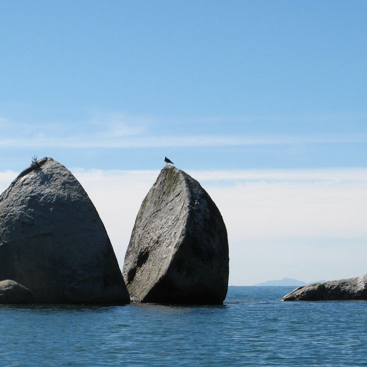
This granite boulder stands 18 meters (59 feet) tall off the coast of Tasman Bay. Split Apple Rock consists of two halves separated by geological forces over thousands of years. The formation is visible from shore and accessible on foot during low tide. Clear water and the symmetrical split of the rock create unusual photographic perspectives that make this natural landmark a popular subject for travelers documenting New Zealand's geological diversity.
Rangitoto Island emerged about 600 years ago and forms the youngest volcanic island in the Hauraki Gulf near Auckland. The island consists of black lava formations covered with pohutukawa trees. The summit reaches 850 feet (260 meters) above sea level and provides views across Auckland and Waitemata Harbour. Several walking tracks cross through cooled lava fields and dormant craters. This volcanic island ranks among New Zealand's photographed natural formations.
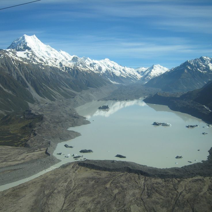
This glacier stretches 14 miles (23 kilometers) through the New Zealand Alps and terminates in a lake where broken ice fragments gather. Tasman Glacier has been retreating since the 1970s, creating an expanding glacial lake in the process. Boat tours navigate between the floating icebergs and provide close views of the glacial formations. Access is via walking tracks and organized excursions departing from Mount Cook Village.
The Waipoua Forest in Northland protects Tane Mahuta, an approximately 2000-year-old kauri tree with a trunk girth measuring 45 feet (13.7 meters). This forest represents one of the most significant remaining kauri forest areas in New Zealand and offers photographers opportunities to document massive tree specimens in their natural habitat. Walking tracks lead to several ancient kauri trees that rank among the country's most photogenic natural subjects due to their extraordinary size and age. The protected status of this forest underscores its ecological importance.
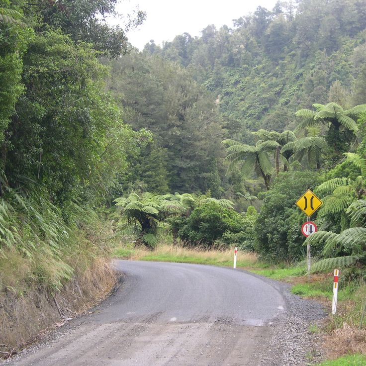
This route extends 96 miles (155 kilometers) through the inland region of the North Island, passing through four tunnels and more than 200 tight curves. The Forgotten World Highway connects Stratford to Taumarunui through thinly populated farmland and native bush. Travelers pass historic bridges, abandoned settlements and occasional sheep herds grazing on surrounding hills. The road follows old Māori trails and later settler routes through territory that remained isolated for decades. Photographers document the winding course, rural structures and distant views across forested valleys.
Kerosene Creek flows through native forest south of Rotorua, carrying water heated to about 86 degrees Fahrenheit (30 degrees Celsius) by geothermal activity. The thermal water forms several natural bathing pools along the stream, accessed by a short walk through dense bush. The combination of warm mineral water and forest setting draws photographers and visitors seeking an outdoor bathing experience. Access is free and the site is used by both locals and travelers. The creek's temperature remains consistent year round, fed by underground hot springs.
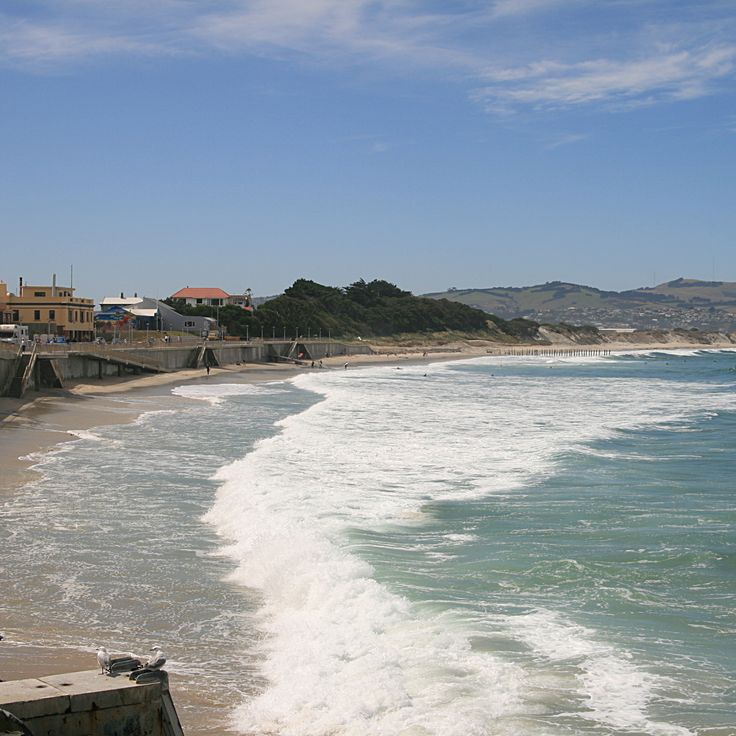
This 1.2-mile (3.5-kilometer) sandy beach on the southern edge of Dunedin attracts surfers who appreciate consistent waves and offers a heated saltwater pool at its southern end. St Clair Beach sits along the Otago Peninsula and features a paved coastal walk suitable for jogging and cycling. The esplanade leads to cafes and restaurants overlooking the Pacific Ocean, while lifeguards patrol sections of the beach during summer months.
This lighthouse from 1897 stands at the southernmost point of the North Island and provides colorful contrast with its red paint against the rocks and the Tasman Sea. The 253 steps lead up to the platform and allow shots of the coastline and fur seal colonies along the cliffs. Wind can be strong here, which challenges photography but also brings dramatic movement to images. Cape Palliser works well for landscape photography with its rugged formations and ocean expanse.
This peninsula extends into the Pacific Ocean and provides observation points for marine mammals including sperm whales, fur seals and dolphins. The waters off the coast reach depths exceeding 3,300 feet (1,000 meters) close to shore, attracting large whale species. Colonies of New Zealand fur seals inhabit the rocky coastal sections, while dolphins appear regularly in the bay. Walking trails along the peninsula allow for land-based viewing, and several boat operators offer whale watching tours.
Cable Bay displays turquoise water and a pebble beach along Tasman Bay. This location in the Nelson region offers views of D'Urville Island and suits photographers documenting New Zealand's coastal landscapes. The bay combines calm waters with rocky shoreline zones and sits about 12 miles northeast of Nelson. Swimmers and beachgoers use this area during warmer months, while the water color appears most intense in sunlight.
Waioeka Gorge is a forested canyon east of Opotiki, where the Waioeka River cuts through native bush. The highway between Bay of Plenty and Gisborne runs through this landscape, covered by indigenous podocarp forest. Several marked trails lead to viewpoints above the river, where visitors photograph the steep slopes and waterfalls. The gorge extends for roughly 30 miles (50 kilometers) and offers numerous pullouts along the route, displaying geological formations and dense vegetation.
This mountain reaches an elevation of 9,951 feet (3,033 meters) in Southland's national park and offers trails through alpine terrain with glaciers. Mount Aspiring is a popular location for landscape photographers in New Zealand and displays the striking mountain panorama of the Southern Alps. The area surrounding the mountain includes valleys, rivers and glaciated slopes that provide different perspectives for photography. Hikers access viewpoints on marked trails of varying difficulty throughout the park.
This gorge near Raglan cuts through volcanic terrain to the sea, offering views of black sand and the Tasman Sea. The formation extends from the uplands to the coastline, creating a contrast between rock formations and waves. Visitors find a perspective on New Zealand's west coast, where volcanic activity shaped the shoreline. The gorge connects the interior to the ocean, showing the geological history of the Waikato region.
These geothermal silica terraces formed through mineral-rich water from underground springs and demonstrate the volcanic activity of the Taupō region. The terraces reach temperatures up to 95°F (35°C) and are fed by water carrying dissolved silica, which has deposited over decades to create the characteristic formations. Wairakei Terraces provides visitors access to several pools at varying temperatures, surrounded by steaming formations of white and ochre-colored sinter. The site sits within a geothermal zone where hot springs and geysers shape the landscape.
This lake sits in the Canterbury Region between peaks of the Southern Alps at an elevation of 1,710 feet (520 m) and covers 21 square miles (54 km²). Lake Ohau provides views across glaciated mountain ranges and forms a photographic setting with clear water reflecting the surrounding mountain slopes. The shores are lined with tussock grassland while snow-capped peaks rise in the background. The lake works for shots in varying light conditions, from early morning reflections to sunsets over the alpine ridges. Access roads allow for several vantage points along the shoreline, offering different perspectives of the mountain landscape.
This 33-foot (10-meter) waterfall in the Catlins sits within a forested area of native trees and large ferns. A short walking track leads to the viewing platform where visitors can photograph the cascade. Matai Falls represents one of New Zealand's natural photographic subjects, showcasing the forested backcountry of the southeastern coastal region. The waterfall is part of a landscape of rainforest vegetation and offers opportunities for nature photography. Access is via a walking track that passes through native vegetation. The Catlins region contains several waterfalls and forested areas for visitors seeking to photograph locations away from main travel routes.
This permanent film location covers 5.7 hectares (14 acres) of farmland in the Matamata-Piako District and was built for the Hobbit and Lord of the Rings films. Hobbiton Movie Set contains 44 hobbit holes with different sizes of round doors set into hillsides. The site features detailed gardens, a working vegetable garden, the Green Dragon Inn and the Mill pond. The hobbit holes range from large versions for Gandalf scenes to smaller ones that represent the size differences between characters. Visitors follow guided tours through the Shire set, which remained after filming as a permanent attraction.
This freshwater lake in the New Zealand Alps sits at an elevation of 2,300 feet (700 meters) and displays its turquoise color from finely ground glacial rock suspended in the mineral-rich water. Lake Tekapo draws its waters from surrounding glaciers and ranks among New Zealand's most photographed locations. The setting provides clear views of the Southern Alps and lies within one of the world's darkest sky reserves, making the lake particularly suitable for night photography. The lake stretches roughly 17 miles (27 kilometers) through the Mackenzie District and attracts photographers for its color contrasts between water, mountains and sky.
This fjord stretches 16 kilometers inland, with vertical rocky walls that drop up to 265 meters into the water. Milford Sound has steady waterfalls that flow down from the surrounding peaks, including Mitre Peak, which stands 1692 meters tall. Regular rain creates temporary waterfalls along the cliffs, while the dark water is tinted by the tannins from the nearby rainforest. Boat and kayak trips follow the sides of the fjord, where seals rest on rocks and dolphins sometimes appear.
Mount Cook National Park covers 70696 hectares in the Canterbury region and contains 23 peaks above 3000 meters as well as 72 named glaciers. The park includes Aoraki/Mount Cook, the tallest mountain in New Zealand at 3724 meters, and shows alpine terrain from glacier valleys to mountain lakes. The land here is among the most photographed in New Zealand, with mountain formations stretching through the Southern Alps and glaciers like the Tasman Glacier, the longest in the country. Trails lead to viewpoints over the Hooker Valley and places where snow, rocks, and alpine plants can be seen together.
This natural cove on the Coromandel Peninsula features an 82-foot (25-meter) limestone arch rising over white sand. Cathedral Cove is accessible only by foot, kayak or boat. The turquoise water and pale rock formations attract photographers documenting New Zealand's coastal landscape. The beach is part of a marine reserve. A walking track from the Hahei car park leads to the beach in roughly 30 minutes, passing through native bush with views across the Pacific.
This geothermal reserve near Rotorua presents a landscape of mineral pools created by volcanic activity. The pools contain various chemical compounds that produce colors ranging from orange to green. Visitors follow walking tracks along steaming craters and past silica terraces. The Champagne Pool, named for rising gas bubbles, reaches temperatures around 165°F (75°C). The Lady Knox Geyser erupts daily at a set time, reaching heights up to 65 feet (20 meters). Wai-O-Tapu Thermal Wonderland makes accessible the geothermal activity that defines this region of New Zealand.
The Waitomo Caves are an underground cave system in Waitomo District where thousands of New Zealand glowworm larvae illuminate the ceilings. These caves rank among the most photogenic locations in New Zealand, offering visitors the opportunity to photograph the luminous larvae of Arachnocampa luminosa during boat rides through the dark chambers. The bioluminescent larvae create a natural light display resembling a starlit sky. The cave system extends across multiple levels and includes both dry and flooded sections formed by underground rivers.
These distinctive spherical boulders of calcium carbonate lie scattered across Koekohe Beach and formed through sedimentation and erosion over approximately 60 million years. The Moeraki Boulders reach diameters up to 7 feet (2 meters) and weigh several tons. Geologists have determined that the boulders grew through crystallization of minerals around an organic core while the surrounding mudstone gradually eroded away by the sea. Maori associate the formation with legends of a sunken canoe. Visitors reach the boulders via a short path from the car park on State Highway 1, approximately 25 miles (40 kilometers) south of Oamaru.
This 1578-meter high summit offers a wide view of Lake Wānaka, the nearby peaks of the Southern Alps, and the valley of Matukituki in the Otago region. The steep trail climbs through pastures and rocky terrain for about 16 kilometers round trip, with the final sections being especially exposed. From the top, you can see as far as Mount Aspiring to the west, the deep blue lake below, and the mountain ranges stretching to the horizon. Roy's Peak has become one of the most photographed spots in New Zealand, mainly because of the view of the lake and mountains from a high position, especially clear in good weather.
This northernmost point of mainland New Zealand marks where the Pacific Ocean and Tasman Sea meet in often turbulent waters. An old pohutukawa tree stands at this cape, which holds significance in Maori culture as the place where spirits depart for their ancestral homeland. Cape Reinga offers views across the converging seas and rocky coastline. A lighthouse built in 1941 marks the exposed position at the tip of the Aupouri Peninsula, making it a photographic location that captures both natural geography and cultural meaning.
This trail extends 19 kilometers (12 miles) across Tongariro National Park, connecting active volcanic cones with crater lakes and alpine vegetation. The route crosses lava tongues and ash plateaus between Mount Ngauruhoe and Mount Tongariro, where turquoise lakes have formed in volcanic craters. The path climbs to approximately 6,200 feet (1,900 meters) and provides views across the central volcanic plateau of the North Island. Hikers traverse different geological zones that document the volcanic history of the region.
Piha Beach extends along the coast with black volcanic sand and ranks among the most recognized surf beaches near Auckland. The waves reach substantial heights and draw surfers from across New Zealand and beyond. Lion Rock, a prominent formation, rises approximately 330 feet (100 m) from the water and serves as a landmark. The beach sits 28 miles (45 km) west of the city and connects via a winding road through dense rainforest. The powerful surf and unpredictable currents require caution when swimming.
This beach on the Coromandel Peninsula offers an unusual geological phenomenon where hot springs emerge through the sand, allowing visitors to dig their own warm pools at low tide. Hot Water Beach represents one of New Zealand's photogenic locations where geothermal activity meets coastal landscape. The best time to visit falls within two hours either side of low tide, when the sand is accessible and thermal water reaches the surface.
This volcano stands at 2518 meters above sea level and is among the most symmetrical volcanic cones in the world. Mount Taranaki offers several hiking trails, from climbs to the summit to day walks through the park’s vegetation areas. The geological formation is about 120000 years old and last erupted in the 18th century. Photographers find subjects ranging from mountain landscapes to dense tropical forests covering the lower parts of the mountain.
This viewpoint at 1,640 feet (500 meters) elevation offers hiking trails through the mountains above Queenstown. From the summit, visitors see the town, Lake Wakatipu and the Remarkables range. The ascent takes roughly two hours and passes through forest sections with native trees. The viewing platform suits photographers capturing the Wakatipu Basin and surrounding peaks. The track begins at the edge of town and climbs steadily, with several rest points providing opportunities to observe the changing perspective over the lake and mountain terrain.
This castle, built in 1871 for banker William Larnach, combines Scottish architectural elements with New Zealand craftsmanship on the Otago Peninsula. The interior features period furnishings from the Victorian era, including Italian marble work and carved wood paneling sourced from native timbers. The gardens include formal layouts, a rockery, and themed sections restored since the 1990s. Visitors can walk through the various rooms furnished with Larnach family items and view the coastline and Dunedin harbor. The estate documents the history of 19th-century New Zealand upper-class residences and represents the photographic diversity that New Zealand offers between historic structures and natural landscapes.
This geothermal park in Rotorua anchors the collection of photogenic locations across New Zealand through its complex of over 500 thermal springs, mud pools and the Pohutu Geyser. The valley demonstrates ongoing volcanic activity with steam clouds, boiling water and mineral deposits. The Pohutu Geyser reaches heights of up to 100 feet (30 meters) and erupts multiple times daily. Visitors also encounter a Māori cultural center featuring carving workshops and traditional meeting houses. The thermal fields produce characteristic colors ranging from white to yellow to orange through different mineral deposits.
This glacier descends from the Southern Alps through temperate rainforest to an elevation of 980 feet (300 meters) above sea level. Franz Josef Glacier ranks among the most photographed sites on New Zealand's South Island, offering visitors access to ice formations that extend into densely vegetated valleys. Guided walks traverse the glacier surface, while helicopter tours provide views of the ice flows and surrounding peaks. The area demonstrates the interaction between glacial and subtropical climate zones within a compact geographic area.
This waterfall descends in three distinct tiers across a combined drop of 65 feet (20 meters) through native podocarp forest. Water flows over broad rock faces surrounded by dense ferns and tree canopy. The falls lie within Catlins Forest Park and rank among the most photographed natural attractions in New Zealand. A short walk of approximately 10 minutes leads from the parking area to the viewing platform, which provides clear views of all three cascades. The site works particularly well for photography during early morning hours or under overcast conditions when light distributes evenly across the scene.
This 1870 lighthouse stands on a rocky headland along the South Island's southeastern coast and provides photo opportunities with offshore rock formations that resemble gold nuggets. Nugget Point ranks among New Zealand's accessible coastal locations where visitors observe sea lions, fur seals and yellow-eyed penguins. The platform at the lighthouse enables wide-angle shots of the rugged coastline and South Pacific. A walking track of approximately 10 minutes connects the car park to the lighthouse. The exposed position creates changing light conditions for landscape photography throughout the day and at sunset.
These suspension bridges crossing the turquoise Makarora River provide views of the clear pools in Mount Aspiring National Park. A forest trail of about 0.9 miles (1.5 kilometers) through beech woodland leads from the roadside to the pools. The intense coloration results from suspended glacial particles in the water. Photographers find good lighting conditions here particularly in the morning when the sun reaches the water surface. The track is generally well maintained, though it can become slippery after rain. The pools rank among the most accessible photographic subjects along State Highway 6 between Wanaka and Haast.
Whangarei Falls is a 85-foot (26-meter) waterfall over basalt columns in Northland that provides multiple viewpoints for photographers. A loop track leads to three platforms at the upper and lower sections of the falls. Water drops over volcanic rock formations into a pool below, creating different perspectives depending on position. Surrounding vegetation of native ferns and trees frames shots from each platform. The platforms allow compositions from various angles and elevations. This waterfall is among the photographic locations across New Zealand that range from mountains and beaches to urban centers.
Tunnel Beach lies south of Dunedin and takes its name from a hand carved tunnel cut through rock in the 1870s to provide access to the shore. The limestone cliffs along the coastline contain visible fossils and display geological formations shaped over millions of years. The beach itself sits in a sheltered cove surrounded by steep rock walls. Walking tracks run along the clifftops and provide views across the South Pacific. The area attracts photographers for its unusual rock formations and the tunnel entrance, making it one of the most photogenic locations across New Zealand.
This lake formed 14,000 years ago from a retreating glacier and provides reflections of the Southern Alps in its dark waters during calm conditions. Lake Matheson sits near Fox Glacier and is accessed via a 1.6-mile (2.6-kilometer) walking track that takes around 90 minutes to complete. The best reflections appear during early morning hours when Aoraki Mount Cook and Mount Tasman are visible in the water. The dark color comes from organic matter leached from surrounding vegetation.
This granite boulder stands 18 meters (59 feet) tall off the coast of Tasman Bay. Split Apple Rock consists of two halves separated by geological forces over thousands of years. The formation is visible from shore and accessible on foot during low tide. Clear water and the symmetrical split of the rock create unusual photographic perspectives that make this natural landmark a popular subject for travelers documenting New Zealand's geological diversity.
Rangitoto Island emerged about 600 years ago and forms the youngest volcanic island in the Hauraki Gulf near Auckland. The island consists of black lava formations covered with pohutukawa trees. The summit reaches 850 feet (260 meters) above sea level and provides views across Auckland and Waitemata Harbour. Several walking tracks cross through cooled lava fields and dormant craters. This volcanic island ranks among New Zealand's photographed natural formations.
This glacier stretches 14 miles (23 kilometers) through the New Zealand Alps and terminates in a lake where broken ice fragments gather. Tasman Glacier has been retreating since the 1970s, creating an expanding glacial lake in the process. Boat tours navigate between the floating icebergs and provide close views of the glacial formations. Access is via walking tracks and organized excursions departing from Mount Cook Village.
The Waipoua Forest in Northland protects Tane Mahuta, an approximately 2000-year-old kauri tree with a trunk girth measuring 45 feet (13.7 meters). This forest represents one of the most significant remaining kauri forest areas in New Zealand and offers photographers opportunities to document massive tree specimens in their natural habitat. Walking tracks lead to several ancient kauri trees that rank among the country's most photogenic natural subjects due to their extraordinary size and age. The protected status of this forest underscores its ecological importance.
This route extends 96 miles (155 kilometers) through the inland region of the North Island, passing through four tunnels and more than 200 tight curves. The Forgotten World Highway connects Stratford to Taumarunui through thinly populated farmland and native bush. Travelers pass historic bridges, abandoned settlements and occasional sheep herds grazing on surrounding hills. The road follows old Māori trails and later settler routes through territory that remained isolated for decades. Photographers document the winding course, rural structures and distant views across forested valleys.
Kerosene Creek flows through native forest south of Rotorua, carrying water heated to about 86 degrees Fahrenheit (30 degrees Celsius) by geothermal activity. The thermal water forms several natural bathing pools along the stream, accessed by a short walk through dense bush. The combination of warm mineral water and forest setting draws photographers and visitors seeking an outdoor bathing experience. Access is free and the site is used by both locals and travelers. The creek's temperature remains consistent year round, fed by underground hot springs.
This 1.2-mile (3.5-kilometer) sandy beach on the southern edge of Dunedin attracts surfers who appreciate consistent waves and offers a heated saltwater pool at its southern end. St Clair Beach sits along the Otago Peninsula and features a paved coastal walk suitable for jogging and cycling. The esplanade leads to cafes and restaurants overlooking the Pacific Ocean, while lifeguards patrol sections of the beach during summer months.
This lighthouse from 1897 stands at the southernmost point of the North Island and provides colorful contrast with its red paint against the rocks and the Tasman Sea. The 253 steps lead up to the platform and allow shots of the coastline and fur seal colonies along the cliffs. Wind can be strong here, which challenges photography but also brings dramatic movement to images. Cape Palliser works well for landscape photography with its rugged formations and ocean expanse.
This peninsula extends into the Pacific Ocean and provides observation points for marine mammals including sperm whales, fur seals and dolphins. The waters off the coast reach depths exceeding 3,300 feet (1,000 meters) close to shore, attracting large whale species. Colonies of New Zealand fur seals inhabit the rocky coastal sections, while dolphins appear regularly in the bay. Walking trails along the peninsula allow for land-based viewing, and several boat operators offer whale watching tours.
Cable Bay displays turquoise water and a pebble beach along Tasman Bay. This location in the Nelson region offers views of D'Urville Island and suits photographers documenting New Zealand's coastal landscapes. The bay combines calm waters with rocky shoreline zones and sits about 12 miles northeast of Nelson. Swimmers and beachgoers use this area during warmer months, while the water color appears most intense in sunlight.
Waioeka Gorge is a forested canyon east of Opotiki, where the Waioeka River cuts through native bush. The highway between Bay of Plenty and Gisborne runs through this landscape, covered by indigenous podocarp forest. Several marked trails lead to viewpoints above the river, where visitors photograph the steep slopes and waterfalls. The gorge extends for roughly 30 miles (50 kilometers) and offers numerous pullouts along the route, displaying geological formations and dense vegetation.
This mountain reaches an elevation of 9,951 feet (3,033 meters) in Southland's national park and offers trails through alpine terrain with glaciers. Mount Aspiring is a popular location for landscape photographers in New Zealand and displays the striking mountain panorama of the Southern Alps. The area surrounding the mountain includes valleys, rivers and glaciated slopes that provide different perspectives for photography. Hikers access viewpoints on marked trails of varying difficulty throughout the park.
This gorge near Raglan cuts through volcanic terrain to the sea, offering views of black sand and the Tasman Sea. The formation extends from the uplands to the coastline, creating a contrast between rock formations and waves. Visitors find a perspective on New Zealand's west coast, where volcanic activity shaped the shoreline. The gorge connects the interior to the ocean, showing the geological history of the Waikato region.
These geothermal silica terraces formed through mineral-rich water from underground springs and demonstrate the volcanic activity of the Taupō region. The terraces reach temperatures up to 95°F (35°C) and are fed by water carrying dissolved silica, which has deposited over decades to create the characteristic formations. Wairakei Terraces provides visitors access to several pools at varying temperatures, surrounded by steaming formations of white and ochre-colored sinter. The site sits within a geothermal zone where hot springs and geysers shape the landscape.
This lake sits in the Canterbury Region between peaks of the Southern Alps at an elevation of 1,710 feet (520 m) and covers 21 square miles (54 km²). Lake Ohau provides views across glaciated mountain ranges and forms a photographic setting with clear water reflecting the surrounding mountain slopes. The shores are lined with tussock grassland while snow-capped peaks rise in the background. The lake works for shots in varying light conditions, from early morning reflections to sunsets over the alpine ridges. Access roads allow for several vantage points along the shoreline, offering different perspectives of the mountain landscape.
This 33-foot (10-meter) waterfall in the Catlins sits within a forested area of native trees and large ferns. A short walking track leads to the viewing platform where visitors can photograph the cascade. Matai Falls represents one of New Zealand's natural photographic subjects, showcasing the forested backcountry of the southeastern coastal region. The waterfall is part of a landscape of rainforest vegetation and offers opportunities for nature photography. Access is via a walking track that passes through native vegetation. The Catlins region contains several waterfalls and forested areas for visitors seeking to photograph locations away from main travel routes.
Visiting New Zealand means knowing that each turn offers something new. Plan more time than you think. You will want to stop often to take photos. Weather changes quickly in the mountains, so check the forecasts before trips. Bring clothes for all weather, even in summer.